
Minnesota Administrative Rules
CHAPTER 7050, WATERS OF THE STATE
MINNESOTA POLLUTION CONTROL AGENCY
| Part | Title |
|---|---|
| 7050.0100 | [Repealed, 9 SR 913] |
| WATER QUALITY STANDARDS FOR PROTECTION OF WATERS OF THE STATE |
|
| 7050.0110 | SCOPE. |
| 7050.0120 | [Repealed, 9 SR 913] |
| 7050.0130 | GENERAL DEFINITIONS. |
| 7050.0140 | USE CLASSIFICATIONS FOR WATERS OF THE STATE. |
| 7050.0150 | DETERMINATION OF WATER QUALITY, BIOLOGICAL AND PHYSICAL CONDITIONS, AND COMPLIANCE WITH STANDARDS. |
| 7050.0160 | [Repealed, 9 SR 913] |
| 7050.0170 | NATURAL WATER QUALITY. |
| 7050.0180 | NONDEGRADATION FOR OUTSTANDING RESOURCE VALUE WATERS. |
| 7050.0185 | NONDEGRADATION FOR ALL WATERS. |
| 7050.0186 | WETLAND STANDARDS AND MITIGATION. |
| 7050.0190 | VARIANCE FROM STANDARDS. |
| 7050.0200 | [Repealed, 32 SR 1699] |
| 7050.0210 | GENERAL STANDARDS FOR WATERS OF THE STATE. |
| 7050.0211 | [Repealed, 32 SR 1699] |
| 7050.0212 | [Repealed, 32 SR 1699] |
| 7050.0213 | [Repealed, 32 SR 1699] |
| 7050.0214 | [Repealed, 32 SR 1699] |
| 7050.0215 | [Repealed, 32 SR 1699] |
| 7050.0216 | [Repealed, 32 SR 1699] |
| 7050.0217 | OBJECTIVES FOR PROTECTION OF SURFACE WATERS FROM TOXIC POLLUTANTS. |
| 7050.0218 | FOR TOXIC POLLUTANTS: DEFINITIONS AND METHODS FOR DETERMINATION OF HUMAN HEALTH-BASED NUMERIC STANDARDS AND SITE-SPECIFIC NUMERIC CRITERIA FOR AQUATIC LIFE, HUMAN HEALTH, AND FISH-EATING WILDLIFE. |
| 7050.0219 | HUMAN HEALTH-BASED CRITERIA AND STANDARDS. |
| 7050.0220 | SPECIFIC WATER QUALITY STANDARDS BY ASSOCIATED USE CLASSES. |
| 7050.0221 | SPECIFIC WATER QUALITY STANDARDS FOR CLASS 1 WATERS OF THE STATE; DOMESTIC CONSUMPTION. |
| 7050.0222 | SPECIFIC WATER QUALITY STANDARDS FOR CLASS 2 WATERS OF THE STATE; AQUATIC LIFE AND RECREATION. |
| 7050.0223 | SPECIFIC WATER QUALITY STANDARDS FOR CLASS 3 WATERS OF THE STATE; INDUSTRIAL CONSUMPTION. |
| 7050.0224 | SPECIFIC WATER QUALITY STANDARDS FOR CLASS 4 WATERS OF THE STATE; AGRICULTURE AND WILDLIFE. |
| 7050.0225 | SPECIFIC WATER QUALITY STANDARDS FOR CLASS 5 WATERS OF THE STATE; AESTHETIC ENJOYMENT AND NAVIGATION. |
| 7050.0226 | SPECIFIC WATER QUALITY STANDARDS FOR CLASS 6 WATERS OF THE STATE; OTHER USES. |
| 7050.0227 | SPECIFIC WATER QUALITY STANDARDS FOR CLASS 7 WATERS OF THE STATE; LIMITED RESOURCE VALUE WATERS. |
| 7050.0300 | [Repealed, 9 SR 913] |
| 7050.0310 | [Repealed, 9 SR 913] |
| 7050.0320 | [Repealed, 9 SR 913] |
| 7050.0330 | [Repealed, 9 SR 913] |
| 7050.0340 | [Repealed, 9 SR 913] |
| 7050.0350 | [Repealed, 9 SR 913] |
| 7050.0360 | [Repealed, 9 SR 913] |
| 7050.0370 | [Repealed, 9 SR 913] |
| 7050.0380 | [Repealed, 9 SR 913] |
| CLASSIFICATIONS | |
| 7050.0400 | BENEFICIAL USE CLASSIFICATIONS FOR SURFACE WATERS; SCOPE. |
| 7050.0405 | PETITION BY OUTSIDE PARTY TO CONSIDER ATTAINABILITY OF USE. |
| 7050.0410 | LISTED WATERS. |
| 7050.0420 | TROUT WATERS. |
| 7050.0425 | UNLISTED WETLANDS. |
| 7050.0430 | UNLISTED WATERS. |
| 7050.0440 | OTHER CLASSIFICATIONS SUPERSEDED. |
| 7050.0450 | MULTICLASSIFICATIONS. |
| 7050.0460 | WATERS SPECIFICALLY CLASSIFIED; EXPLANATION OF LISTINGS IN PART 7050.0470. |
| 7050.0465 | [Repealed, 18 SR 2195] |
| 7050.0466 | MAP: MAJOR SURFACE WATER DRAINAGE BASINS. |
| 7050.0467 | [Repealed, 39 SR 154] |
| 7050.0468 | MAP: MINNESOTA ECOREGIONS. |
| 7050.0470 | CLASSIFICATIONS FOR SURFACE WATERS IN MAJOR DRAINAGE BASINS. |
| 7050.0480 | [Renumbered 7050.0465] |
7050.0100
[Repealed, 9 SR 913]
Published Electronically:
April 1, 2008
WATER QUALITY STANDARDS FOR PROTECTION OF
WATERS OF THE STATE
7050.0110 SCOPE.
Parts 7050.0130 to 7050.0227 apply to all waters of the state, both surface and underground. This chapter includes a classification system of beneficial uses applicable to waters of the state, narrative and numeric water quality standards that protect specific beneficial uses, nondegradation provisions, and other provisions to protect the physical, chemical, and biological integrity of waters of the state. Parts 7050.0400 to 7050.0470 classify all surface waters within or bordering Minnesota and designate the beneficial uses for which these waters are protected. This chapter applies to point source and nonpoint source discharges and to the physical alterations of wetlands. Other water quality rules of general or specific application that include any more stringent water quality standards or prohibitions are preserved.
Effluent limits and treatment requirements for discharges of sewage, industrial wastes, and other wastes are located in chapter 7053.
History:
9 SR 913; 12 SR 1810; 18 SR 2195; 32 SR 1699
Published Electronically:
April 1, 2008
7050.0120
[Repealed, 9 SR 913]
Published Electronically:
April 1, 2008
7050.0130 GENERAL DEFINITIONS.
Subp. 2.
Terms defined in statute.
The terms "waters of the state," "groundwater," "water pollution," and "toxic pollutants," as well as any other terms for which definitions are given in the pollution control statutes, as used herein have the meanings given to them in Minnesota Statutes, sections 115.01 and 115.41, with the exception that disposal systems or treatment works operated under permit or certificate of compliance of the agency are not "waters of the state."
Subp. 3.
Seven-day ten-year low flow or 7Q10.
A.
"Seven-day ten-year low flow" or "7Q10 " means the lowest average seven-day flow with a once in ten-year recurrence interval. A 7Q10 is derived by identifying the lowest average flow for a seven-consecutive-day period from daily flow records for each year of record, from a continuous flow gauging station. The seven-day average low flow values for each year are arrayed in order of magnitude and fitted to a probability distribution. The 7Q10 is the stream or river flow that is equal to or exceeded by 90 percent of the values in the distribution.
B.
The period of record for determining the specific flow for the stated recurrence interval, where records are available, shall include at least the most recent ten years of record, including flow records obtained after establishment of flow regulation devices, if any. Where stream flow records are not available, the flow may be estimated on the basis of available information on the watershed characteristics, precipitation, runoff, and other relevant data. The calculations shall not be applied to lakes and their embayments which have no comparable flow recurrence interval.
Subp. 4.
Commissioner.
"Commissioner" means the commissioner of the Minnesota Pollution Control Agency or the commissioner's designee.
Subp. 5.
Nonpoint source.
"Nonpoint source" means a land management or land use activity that contributes or may contribute to ground and surface water pollution as a result of runoff, seepage, or percolation and that is not defined as a point source under Minnesota Statutes, section 115.01, subdivision 11.
Subp. 6.
Surface waters.
"Surface waters" means waters of the state excluding groundwater as defined in Minnesota Statutes, section 115.01, subdivision 6.
Subp. 7.
Other terms.
Other terms and abbreviations used in this chapter are defined in the part in which they are used. Terms and abbreviations used in this chapter that are not specifically defined in applicable federal or state law shall be construed in conformance with the context, and in relation to the applicable section of the statutes pertaining to the matter, and current professional usage.
History:
9 SR 913; 12 SR 1810; 15 SR 1057; 18 SR 2195; 32 SR 1699
Published Electronically:
April 1, 2008
7050.0140 USE CLASSIFICATIONS FOR WATERS OF THE STATE.
Subpart 1.
Introduction.
Based on considerations of best usage and the need for water quality protection in the interest of the public, and in conformance with the requirements of Minnesota Statutes, section 115.44, the waters of the state are grouped into one or more of the classes in subparts 2 to 8. The classifications are listed in parts 7050.0400 to 7050.0470. The classifications should not be construed to be in order of priority, nor considered to be exclusive or prohibitory of other beneficial uses.
Subp. 2.
Class 1 waters, domestic consumption.
Domestic consumption includes all waters of the state that are or may be used as a source of supply for drinking, culinary or food processing use, or other domestic purposes and for which quality control is or may be necessary to protect the public health, safety, or welfare.
Subp. 3.
Class 2 waters, aquatic life and recreation.
Aquatic life and recreation includes all waters of the state that support or may support fish, other aquatic life, bathing, boating, or other recreational purposes and for which quality control is or may be necessary to protect aquatic or terrestrial life or their habitats or the public health, safety, or welfare.
Subp. 4.
Class 3 waters, industrial consumption.
Industrial consumption includes all waters of the state that are or may be used as a source of supply for industrial process or cooling water, or any other industrial or commercial purposes, and for which quality control is or may be necessary to protect the public health, safety, or welfare.
Subp. 5.
Class 4 waters, agriculture and wildlife.
Agriculture and wildlife includes all waters of the state that are or may be used for any agricultural purposes, including stock watering and irrigation, or by waterfowl or other wildlife and for which quality control is or may be necessary to protect terrestrial life and its habitat or the public health, safety, or welfare.
Subp. 6.
Class 5 waters, aesthetic enjoyment and navigation.
Aesthetic enjoyment and navigation includes all waters of the state that are or may be used for any form of water transportation or navigation or fire prevention and for which quality control is or may be necessary to protect the public health, safety, or welfare.
Subp. 7.
Class 6 waters, other uses and protection of border waters.
Other uses includes all waters of the state that serve or may serve the uses in subparts 2 to 6 or any other beneficial uses not listed in this part, including without limitation any such uses in this or any other state, province, or nation of any waters flowing through or originating in this state, and for which quality control is or may be necessary for the declared purposes in this part, to conform with the requirements of the legally constituted state or national agencies having jurisdiction over such waters, or for any other considerations the agency may deem proper.
Subp. 8.
Class 7 waters, limited resource value waters.
Limited resource value waters include surface waters of the state that have been subject to a use attainability analysis and have been found to have limited value as a water resource. Water quantities in these waters are intermittent or less than one cubic foot per second at the 7Q10 flow as defined in part 7050.0130, subpart 3. These waters shall be protected so as to allow secondary body contact use, to preserve the groundwater for use as a potable water supply, and to protect aesthetic qualities of the water. It is the intent of the agency that very few waters be classified as limited resource value waters. The use attainability analysis must take into consideration those factors listed in Minnesota Statutes, section 115.44, subdivisions 2 and 3. The agency, in cooperation and agreement with the Department of Natural Resources with respect to determination of fisheries values and potential, shall use this information to determine the extent to which the waters of the state demonstrate that:
A.
the existing and potential faunal and floral communities are severely limited by natural conditions as exhibited by poor water quality characteristics, lack of habitat, or lack of water;
B.
the quality of the resource has been significantly altered by human activity and the effect is essentially irreversible; or
C.
there are limited recreational opportunities, such as fishing, swimming, wading, or boating, in and on the water resource.
The conditions in items A and C or B and C must be established by the use attainability analysis before the waters can be classified as limited resource value waters.
History:
9 SR 913; 32 SR 1699
Published Electronically:
April 1, 2008
7050.0150 DETERMINATION OF WATER QUALITY, BIOLOGICAL AND PHYSICAL CONDITIONS, AND COMPLIANCE WITH STANDARDS.
Subpart 1.
Policy and scope.
The intent of the state is to protect and maintain surface waters in a condition which allows for the maintenance of all existing beneficial uses. The condition of a surface water body is determined by its physical, chemical, and biological qualities. The agency shall determine an exceedance of water quality standards or an impaired condition based on pollution of the waters of the state from point and nonpoint sources that has resulted in degradation of the physical, chemical, or biological qualities of the water body to the extent that attainable or previously existing beneficial uses are actually or potentially lost.
The narrative water quality standards in subpart 3 prescribe the qualities or properties of surface waters that are necessary for the protection of designated public uses and benefits. If the narrative standards in this part are exceeded, it is considered indicative of a polluted condition which is actually or potentially deleterious, harmful, detrimental, or injurious with respect to the designated uses of the waters of the state.
Subparts 5 to 7 list factors the commissioner will use to determine if surface waters are in compliance with applicable narrative standards in subpart 3. Determination of compliance with the narrative standards will be made for individual water bodies on a case-by-case basis.
Subp. 2.
Other standards preserved.
The requirements of this part are in addition to the application of other narrative or numeric water quality standards in this chapter. If the requirements of this part conflict with any other narrative or numeric standard in this chapter, the more stringent standard applies.
Subp. 3.
Narrative standards.
For all Class 2 waters, the aquatic habitat, which includes the waters of the state and stream bed, shall not be degraded in any material manner, there shall be no material increase in undesirable slime growths or aquatic plants, including algae, nor shall there be any significant increase in harmful pesticide or other residues in the waters, sediments, and aquatic flora and fauna; the normal fishery and lower aquatic biota upon which it is dependent and the use thereof shall not be seriously impaired or endangered, the species composition shall not be altered materially, and the propagation or migration of the fish and other biota normally present shall not be prevented or hindered by the discharge of any sewage, industrial waste, or other wastes to the waters.
Subp. 4.
Definitions.
For the purposes of this chapter and chapter 7053, the following terms have the meanings given them.
A.
"122-day ten-year low flow" or "122Q10" means the lowest average 122-day flow with a once in ten-year recurrence interval. A 122Q10 is derived using the same methods used to derive a 7Q10, and the guidelines regarding period of record for flow data and estimating a 7Q10 apply equally to determining a 122Q10, as described in part 7050.0130, subpart 3.
B.
"Altered materially," "material increase," "material manner," "seriously impaired," and "significant increase," as used in subparts 3, 5, and 6, mean that pollution of the waters of the state has resulted in degradation of the physical, chemical, or biological qualities of the water body to the extent that attainable or previously existing beneficial uses are actually or potentially lost.
C.
"BOD5" or "five-day biochemical oxygen demand" means the amount of dissolved oxygen needed by aerobic biological organisms to break down organic material present in a given water sample at a certain temperature over a five-day period.
D.
"Chlorophyll-a" means a pigment in green plants including algae. The concentration of chlorophyll-a, expressed in weight per unit volume of water, is a measurement of the abundance of algae.
E.
"Diel flux" means the daily change in a constituent, such as dissolved oxygen or pH, when there is a distinct daily cycle in the measurement. Diel dissolved oxygen flux means the difference between the maximum daily dissolved oxygen concentration and the minimum daily dissolved oxygen concentration.
F.
"Ecoregion" means an area of relative homogeneity in ecological systems based on similar soils, land use, land surface form, and potential natural vegetation. Minnesota ecoregions are shown on the map in part 7050.0468.
G.
"Eutrophication" means the increased productivity of the biological community in water bodies in response to increased nutrient loading. Eutrophication is characterized by increased growth and abundance of algae and other aquatic plants, reduced water transparency, reduction or loss of dissolved oxygen, and other chemical and biological changes. The acceleration of eutrophication due to excess nutrient loading from human sources and activities, called cultural eutrophication, causes a degradation of water quality and possible loss of beneficial uses.
H.
"Eutrophication standard" means the combination of indicators of enrichment and indicators of response as described in subpart 5. The indicators upon which the eutrophication standard for specific water bodies are based are as provided under subparts 5a to 5c.
I.
"Fish and other biota" and "lower aquatic biota" mean the aquatic community including, but not limited to, game and nongame fish, minnows and other small fish, mollusks, insects, crustaceans and other invertebrates, submerged or emergent rooted vegetation, suspended or floating algae, substrate-attached algae, and microscopic organisms. "Other biota" includes aquatic or semiaquatic organisms that depend on aquatic systems for food or habitat such as amphibians and certain wildlife species.
J.
"Hydraulic residence time" means the time water resides in a basin or, alternately, the time it would take to fill the basin if it were empty.
K.
"Impaired water" or "impaired condition" means a water body that does not meet applicable water quality standards or fully support applicable beneficial uses, due in whole or in part to water pollution from point or nonpoint sources, or any combination thereof.
L.
"Index of biological integrity" or "IBI" means an index developed by measuring attributes of an aquatic community that change in quantifiable and predictable ways in response to human disturbance, representing the health of that community.
M.
"Lake" means an enclosed basin filled or partially filled with standing fresh water with a maximum depth greater than 15 feet. Lakes may have no inlet or outlet, an inlet or outlet, or both an inlet and outlet.
N.
"Lake morphometry" means the physical characteristics of the lake basin that are reasonably necessary to determine the shape of a lake, such as maximum length and width, maximum and mean depth, area, volume, and shoreline configuration.
O.
"Mixing status" means the frequency of complete mixing of the lake water from surface to bottom, which is determined by whether temperature gradients are established and maintained in the water column during the summer season.
P.
"Measurable increase" or "measurable impact" means a change in trophic status that can be discerned above the normal variability in water quality data using a weight of evidence approach. The change in trophic status does not require a demonstration of statistical significance to be considered measurable. Mathematical models may be used as a tool in the data analysis to help predict changes in trophic status.
Q.
"Natural causes" means the multiplicity of factors that determine the physical, chemical, or biological conditions that would exist in a water body in the absence of measurable impacts from human activity or influence.
R.
"Normal fishery" and "normally present" mean the fishery and other aquatic biota expected to be present in the water body in the absence of pollution of the water, consistent with any variability due to natural hydrological, substrate, habitat, or other physical and chemical characteristics. Expected presence is based on comparing the aquatic community in the water body of interest to the aquatic community in representative reference water bodies.
S.
"Nuisance algae bloom" means an excessive population of algae that is characterized by obvious green or blue-green pigmentation in the water, floating mats of algae, reduced light transparency, aesthetic degradation, loss of recreational use, possible harm to the aquatic community, or possible toxicity to animals and humans. Algae blooms are measured through tests for chlorophyll-a, observations of Secchi disk transparency, and observations of impaired recreational and aesthetic conditions by the users of the water body, or any other reliable data that identifies the population of algae in an aquatic community.
T.
"Periphyton" means algae on the bottom of a water body. In rivers or streams, these forms are typically found attached to logs, rocks, or other substrates, but when dislodged the algae will become part of the seston.
U.
"Readily available and reliable data and information" means chemical, biological, and physical data and information determined by the commissioner to meet the quality assurance and quality control requirements in subpart 8, that are not more than ten years old from the time they are used for the assessment. A subset of data in the ten-year period, or data more than ten years old can be used if credible scientific evidence shows that these data are representative of current conditions.
V.
"Reference water body" means a water body least impacted by point or nonpoint sources of pollution that is representative of water bodies in the same ecoregion or watershed. Reference water bodies are used as a base for comparing the quality of similar water bodies in the same ecoregion or watershed.
W.
"Reservoir" means a body of water in a natural or artificial basin or watercourse where the outlet or flow is artificially controlled by a structure such as a dam. Reservoirs are distinguished from river systems by having a hydraulic residence time of at least 14 days. For purposes of this item, residence time is determined using a flow equal to the 122Q10 for the months of June through September.
X.
"River nutrient region" means the geographic basis for regionalizing the river eutrophication criteria as described in Heiskary, S. and K. Parson, Regionalization of Minnesota's Rivers for Application of River Nutrient Criteria, Minnesota Pollution Control Agency (2013), which is incorporated by reference. The document is not subject to frequent change and is available through the Minitex interlibrary loan system.
Y.
"Secchi disk" means a tool that is used to measure the transparency of lake water. A Secchi disk is an eight-inch weighted disk on a calibrated rope, either white or with quadrants of black and white. To measure water transparency with a Secchi disk, the disk is viewed from the shaded side of a boat. The depth of the water at the point where the disk reappears upon raising it after it has been lowered beyond visibility is recorded.
Z.
"Secchi disk transparency" means the transparency of water as measured by either a Secchi disk, a Secchi tube, or a transparency tube.
AA.
"Secchi tube" means a tool that is used to measure the transparency of stream or river water. A Secchi tube is a clear plastic tube, one meter in length and 1-3/4 inch in diameter, with a mini-Secchi disk on a string. To measure water transparency, the tube is filled with water collected from a stream or river and, looking into the tube from the top, the weighted Secchi disk is lowered into the tube by a string until it disappears and then raised until it reappears, allowing the user to raise and lower the disk within the same water sample numerous times. The depth of the water at the midpoint between disappearance and reappearance of the disk is recorded in centimeters, which are marked on the side of the tube. If the Secchi disk is visible when it is lowered to the bottom of the tube, the transparency reading is recorded as "greater than 100 centimeters."
BB.
"Seston" means particulate matter suspended in water bodies and includes plankton and organic and inorganic matter.
CC.
"Shallow lake" means an enclosed basin filled or partially filled with standing fresh water with a maximum depth of 15 feet or less or with 80 percent or more of the lake area shallow enough to support emergent and submerged rooted aquatic plants (the littoral zone). It is uncommon for shallow lakes to thermally stratify during the summer. The quality of shallow lakes will permit the propagation and maintenance of a healthy indigenous aquatic community and they will be suitable for boating and other forms of aquatic recreation for which they may be usable. Shallow lakes are differentiated from wetlands and lakes on a case-by-case basis. Wetlands are defined in part 7050.0186, subpart 1a.
DD.
"Summer-average" means a representative average of concentrations or measurements of nutrient enrichment factors, taken over one summer season.
FF.
"Transparency tube" means a tool that is used to measure the transparency of stream or river water. A transparency tube is a graduated clear plastic tube, 24 inches or more in length by 1-1/2 inches in diameter, with a stopper at the bottom end. The inside surface of the stopper is painted black and white. To measure water transparency, the tube is filled with water from a surface water; the water is released through a valve at the bottom end until the painted surface of the stopper is just visible through the water column when viewed from the top of the tube. The depth, in centimeters, is noted. More water is released until the screw in the middle of the painted symbol on the stopper is clearly visible; this depth is noted. The two observed depths are averaged to obtain a transparency measurement.
GG.
"Trophic status or condition" means the productivity of a lake as measured by the phosphorus content, algae abundance, and depth of light penetration.
HH.
"Water body" means a lake, reservoir, wetland, or a geographically defined portion of a river or stream.
Subp. 5.
Impairment of waters due to excess algae or plant growth.
In evaluating whether the narrative standards in subpart 3, which prohibit any material increase in undesirable slime growths or aquatic plants including algae, are being met, the commissioner will use all readily available and reliable data and information for the following factors of use impairment:
A.
representative summer-average concentrations of total phosphorus and total nitrogen measured in the water body;
B.
representative summer-average concentrations of chlorophyll-a seston measured in the water body;
D.
representative summer-average concentrations of five-day biochemical oxygen demand measured in rivers and streams;
E.
representative diel dissolved oxygen flux measurements in rivers and streams as averaged over a minimum of four consecutive days during the summer season;
G.
representative measurements of chlorophyll-a (periphyton) on substrates on the beds of rivers and streams during the summer season; and
Subp. 5a.
Impaired condition; lakes, shallow lakes, and reservoirs.
A.
For lakes, shallow lakes, and reservoirs, a finding of an impaired condition must be supported by data showing:
(2)
at least one factor showing impaired conditions resulting from nutrient overenrichment under subpart 5, items B and C.
B.
The trophic status data described in subpart 5, items A to C and H, must be assessed in light of the magnitude, duration, and frequency of nuisance algae blooms in the water body; and documented impaired recreational and aesthetic conditions observed by the users of the water body due to excess algae or plant growth, reduced transparency, or other deleterious conditions caused by nutrient overenrichment.
C.
Assessment of trophic status and the response of a given water body to nutrient enrichment will take into account the trophic status of reference water bodies; and all relevant factors that affect the trophic status of the given water body appropriate for its geographic region, such as the temperature, morphometry, hydraulic residence time, mixing status, watershed size, and location.
Subp. 5b.
Impaired condition; rivers and streams.
For rivers and streams, a finding of an impaired condition must be supported by data showing:
A.
elevated levels of nutrients under subpart 5, item A, and at least one factor showing impaired conditions resulting from nutrient overenrichment under subpart 5, item B, D, E, F, or H; or
Subp. 5c.
Impaired condition; navigational pools.
For navigational pools, a finding of impaired condition must be supported by data showing:
Subp. 6.
Impairment of biological community and aquatic habitat.
In evaluating whether the narrative standards in subpart 3, which prohibit serious impairment of the normal fisheries and lower aquatic biota upon which they are dependent and the use thereof, material alteration of the species composition, material degradation of stream beds, and the prevention or hindrance of the propagation and migration of fish and other biota normally present, are being met, the commissioner will consider all readily available and reliable data and information for the following factors of use impairment:
A.
an index of biological integrity calculated from measurements of attributes of the resident fish community, including measurements of:
B.
an index of biological integrity calculated from measurements of attributes of the resident aquatic invertebrate community, including measurements of:
C.
an index of biological integrity calculated from measurements of attributes of the resident aquatic plant community, including measurements of:
D.
a quantitative or qualitative assessment of habitat quality, determined by an assessment of:
(1)
stream morphological features that provide spawning, nursery, and refuge areas for fish and invertebrates;
E.
any other scientifically objective, credible, and supportable factors.
A finding of an impaired condition must be supported by data for the factors listed in at least one of items A to C. The biological quality of any given surface water body will be assessed by comparison to the biological conditions determined for a set of reference water bodies which best represents the most natural condition for that surface water body type within a geographic region.
Subp. 7.
Impairment of waters relating to fish for human consumption.
A.
In evaluating whether the narrative standards in subpart 3, which prevent harmful pesticide or other toxic pollutant residues in aquatic flora or fauna, are being met, the commissioner must use the methods in:
B.
If CSft has not been established for a pollutant with chronic standards (CS) applicable in water (CSdfr, CSdev, or CSfr, as defined in parts 7050.0218, subpart 3, item Q, and 7050.0219, subpart 13, item B), the residue levels in fish muscle tissue established by the Minnesota Department of Health must be used to identify surface waters supporting fish for which the Minnesota Department of Health recommends a reduced frequency of fish consumption for the protection of public health. A water body will be considered impaired when the recommended consumption frequency is less than one meal per week, such as one meal per month, for any member of the population. That is, a water body will not be considered impaired if the recommended consumption frequency is one meal per week, or any less restrictive recommendation such as two meals per week, for all members of the population. The impaired condition must be supported with measured data on the contaminant levels in the resident fish.
C.
When making impairment determinations in an individual water body for a pollutant with both a fish tissue-based CCft or CSft and a CS applicable in water, comparison of fish tissue data to the CCft or CSft must be the basis for the final impairment determination.
Subp. 8.
Determination of compliance.
In making tests or analyses of the waters of the state, sewage, industrial wastes, or other wastes to determine compliance with the standards and water quality condition, samples shall be collected in a manner and place, and of such type, number, and frequency as may be considered necessary by the agency from the viewpoint of adequately reflecting the condition of the waters, the composition of the effluents, and the effects of the pollutants upon the specified uses. The samples shall be collected, preserved, and analyzed following accepted quality control and quality assurance methods, and according to the procedures in Code of Federal Regulations, title 40, part 136. The agency may accept or may develop other methods, procedures, guidelines, or criteria for collecting and analyzing samples and measuring water quality characteristics. The commissioner will retain a record of all impairment decisions using the factors in this part, including all supporting data, for a minimum of eight years.
History:
9 SR 913; 15 SR 1057; 18 SR 2195; 27 SR 1217; 31 SR 1168; 32 SR 1699; 39 SR 154; 39 SR 1344
Published Electronically:
March 24, 2015
7050.0160
[Repealed, 9 SR 913]
Published Electronically:
April 1, 2008
7050.0170 NATURAL WATER QUALITY.
The waters of the state may, in a natural condition, have water quality characteristics or chemical concentrations approaching or exceeding the water quality standards. Natural conditions exist where there is no discernible impact from point or nonpoint source pollutants attributable to human activity or from a physical alteration of wetlands. Natural background levels are defined by water quality monitoring. Where water quality monitoring data are not available, background levels can be predicted based on data from a watershed with similar characteristics.
Where natural background levels do not exceed applicable standards, the addition of pollutants from human activity and resulting point or nonpoint source discharges shall be limited such that, in total, the natural background levels and the additions from human activity shall not exceed the standards. When reasonable justification exists to preserve the higher natural quality of a water resource, the commissioner may use the natural background levels that are lower than the applicable site-specific standards to control the addition of the same pollutants from human activity. The reasonable justification must meet the requirements under parts 7050.0180 and 7050.0185.
Where background levels exceed applicable standards, the background levels may be used as the standards for controlling the addition of the same pollutants from point or nonpoint source discharges in place of the standards.
In the adoption of standards for individual waters of the state, the agency will be guided by the standards herein but may make reasonable modifications of the same on the basis of evidence brought forth at a public hearing if it is shown to be desirable and in the public interest to do so in order to encourage the best use of the waters of the state or the lands bordering such waters.
History:
9 SR 913; 12 SR 1810; 18 SR 2195
Published Electronically:
April 1, 2008
7050.0180 NONDEGRADATION FOR OUTSTANDING RESOURCE VALUE WATERS.
Subpart 1.
Policy.
The agency recognizes that the maintenance of existing high quality in some waters of outstanding resource value to the state is essential to their function as exceptional recreational, cultural, aesthetic, or scientific resources. To preserve the value of these special waters, the agency will prohibit or stringently control new or expanded discharges from either point or nonpoint sources to outstanding resource value waters.
Subp. 2.
Definitions.
For the purpose of this part, the following terms have the meanings given them:
A.
"Outstanding resource value waters" are waters within the Boundary Waters Canoe Area Wilderness, Voyageur's National Park, and Department of Natural Resources designated scientific and natural areas, wild, scenic, and recreational river segments, Lake Superior, those portions of the Mississippi River from Lake Itasca to the southerly boundary of Morrison County that are included in the Mississippi Headwaters Board comprehensive plan dated February 12, 1981, and other waters of the state with high water quality, wilderness characteristics, unique scientific or ecological significance, exceptional recreational value, or other special qualities which warrant stringent protection from pollution.
B.
"New discharge" means a discharge that was not in existence on the effective date the outstanding resource value water was designated as described in parts 7050.0460 and 7050.0470.
C.
"Expanded discharge" means, except as noted in this item, a discharge that changes in volume, quality, location, or any other manner after the effective date the outstanding resource value water was designated as described in parts 7050.0460 and 7050.0470, such that an increased loading of one or more pollutants results. In determining whether an increased loading of one or more pollutants would result from the proposed change in the discharge, the agency shall compare the loading that would result from the proposed discharge with the loading allowed by the agency as of the effective date of outstanding resource value water designation. This definition does not apply to the discharge of bioaccumulative chemicals of concern, as defined in part 7052.0010, subpart 4, to outstanding resource value waters in the Lake Superior Basin. For purposes of part 7050.0180, an expanded discharge of a bioaccumulative chemical of concern to an outstanding resource value water in the Lake Superior Basin is defined in part 7052.0010, subpart 18.
Subp. 3.
Prohibited discharges.
No person may cause or allow a new or expanded discharge of any sewage, industrial waste, or other waste to waters within the Boundary Waters Canoe Area Wilderness; those portions of Lake Superior north of latitude 47 degrees, 57 minutes, 13 seconds, east of Hat Point, south of the Minnesota-Ontario boundary, and west of the Minnesota-Michigan boundary; Voyageur's National Park; or Department of Natural Resources designated scientific and natural areas; or to federal or state wild river segments.
Subp. 4.
DNR designated scientific and natural areas.
Department of Natural Resources designated scientific and natural areas include but are not limited to:
Subp. 5.
State designated wild river segments.
State designated wild river segments include but are not limited to:
A.
Kettle River from the site of the former dam at Sandstone to its confluence with the Saint Croix River;
Subp. 6.
Restricted discharges.
No person may cause or allow a new or expanded discharge of any sewage, industrial waste, or other waste to any of the following waters unless there is not a prudent and feasible alternative to the discharge:
B.
those portions of the Mississippi River from Lake Itasca to the southerly boundary of Morrison County that are included in the Mississippi Headwaters Board comprehensive plan dated February 12, 1981;
C.
lake trout lakes, both existing and potential, as determined by the agency in conjunction with the Minnesota Department of Natural Resources, outside the boundaries of the Boundary Waters Canoe Area Wilderness and Voyageurs National Park and identified in parts 7050.0460 to 7050.0470;
E.
calcareous fens identified in subpart 6b.
If a new or expanded discharge to these waters is permitted, the agency shall restrict the discharge to the extent necessary to preserve the existing high quality, or to preserve the wilderness, scientific, recreational, or other special characteristics that make the water an outstanding resource value water.
Subp. 6a.
Federal or state designated scenic or recreational river segments.
Waters with a federal or state scenic or recreational designation include but are not limited to:
B.
Cannon River from northern city limits of Faribault to its confluence with the Mississippi River;
F.
Mississippi River from County State-Aid Highway 7 bridge in Saint Cloud to northwestern city limits of Anoka; and
Subp. 6b.
Calcareous fens.
The following calcareous fens are designated outstanding resource value waters:
J.
Lincoln County: Hole-in-the-Mountain Prairie fen, 6; Pipestone (T.108, R.46, S.1; T.109, R.45, S.31);
Subp. 7.
Unlisted outstanding resource value waters.
The agency shall prohibit or stringently control new or expanded discharges to outstanding resource value waters not specified in subparts 3 to 6b to the extent that this stringent protection is necessary to preserve the existing high quality, or to preserve the wilderness, scientific, recreational, or other special characteristics that make the water an outstanding resource value water.
Subp. 8.
Public hearing.
The agency shall provide an opportunity for a hearing before identifying and establishing additional outstanding resource value waters, before determining the existence or lack of prudent and feasible alternatives under subpart 6, and before prohibiting or restricting new or expanded discharges to outstanding resource value waters under subparts 3, 6, 6a, 6b, and 7.
Subp. 9.
Impact from upstream discharges.
The agency shall require new or expanded discharges to waters that flow into outstanding resource value waters be controlled so as to assure no deterioration in the quality of the downstream outstanding resource value water.
Subp. 10.
Thermal discharges.
If a thermal discharge causes potential water quality impairment, the agency shall implement the nondegradation policy consistent with section 316 of the Clean Water Act, United States Code, title 33, section 1326.
History:
9 SR 913; 12 SR 1810; 15 SR 1057; 18 SR 2195; 22 SR 1466
Published Electronically:
April 1, 2008
7050.0185 NONDEGRADATION FOR ALL WATERS.
Subpart 1.
Policy.
The beneficial uses inherent in water resources are valuable public resources. It is the policy of the state to protect all waters from significant degradation from point and nonpoint sources and wetland alterations and to maintain existing water uses and aquatic and wetland habitats. Existing beneficial uses and the water quality necessary to protect the existing uses must be maintained and protected from point and nonpoint sources of pollution.
It is the policy of the agency that water quality conditions that are better than applicable water quality standards and are better than levels necessary to support existing beneficial uses must be maintained and protected unless the commissioner finds that, after full satisfaction of this part, a lowering of water quality is acceptable. In allowing a lowering of water quality, the existing beneficial uses must be fully maintained and protected and the provisions in subpart 3 must be applied.
Subp. 2.
Definitions.
For the purpose of this part, the following terms have the meanings given them:
B.
"Expanded discharge" means a discharge that changes in volume, quality, location, or any other manner after January 1, 1988, such that an increased loading of one or more pollutants results. In determining whether an increased loading of one or more pollutants would result from the proposed change in discharge, the agency shall compare the loading that would result from the proposed discharge with the loading allowed by the agency on January 1, 1988.
E.
"Economic or social development" means the jobs, taxes, recreational opportunities, and other impacts on the public at large that will result from a new or expanded discharge.
F.
"Toxic pollutant" means a pollutant listed as toxic under section 307(a)(1) of the Clean Water Act, United States Code, title 33, section 1317(a)(1), or as defined by Minnesota Statutes, section 115.01, subdivision 20.
G.
"Significant discharge" means:
(1)
a new discharge of sewage, industrial, or other wastes greater than 200,000 gallons per day to any water other than a class 7, limited resource value water; or
(2)
an expanded discharge of sewage, industrial, or other wastes that expands by more than 200,000 gallons per day and that discharges to any water other than a class 7, limited resource value water; or
(3)
a new or expanded discharge containing any toxic pollutant at a mass loading rate likely to increase the concentration of the toxicant in the receiving water by greater than one percent over the baseline quality. This determination shall be made using:
(a)
data collected from the receiving water or from a water representative of the receiving water;
Subp. 3.
Minimum treatment.
Any person authorized to maintain a new or expanded discharge of sewage, industrial waste, or other waste, whether or not the discharge is significant, shall comply with applicable water quality standards of this chapter and effluent limits in chapter 7053 and other applicable federal and state point source treatment requirements. Nonpoint sources of pollution shall be controlled as required by this chapter, chapters 7020 and 7080, and any other applicable federal or state requirements. All existing beneficial uses shall be maintained in the receiving waters.
Subp. 4.
Additional requirements for significant discharges.
If a person proposes a new or expanded significant discharge from either a point or nonpoint source, the agency shall determine whether additional control measures beyond those required by subpart 3 can reasonably be taken to minimize the impact of the discharge on the receiving water. In making the decision, the agency shall consider the importance of economic and social development impacts of the project, the impact of the discharge on the quality of the receiving water, the characteristics of the receiving water, the cumulative impacts of all new or expanded discharges on the receiving water, the costs of additional treatment beyond what is required in subpart 3, and other matters as shall be brought to the agency's attention.
Subp. 5.
Determination of significance.
A person proposing a new or expanded discharge of sewage, industrial waste, or other wastes shall submit to the commissioner the information required to determine whether the discharge is significant under subpart 2. If the discharge is sewage, the flow rate used to determine significance under this part is the design average wet weather flow for the wettest 30-day period. For discharges of industrial and other wastes, the flow rate to be used is the design maximum daily flow rate. In determining the significance of a discharge to a lake or other nonflowing receiving water, a mixing zone may be established under the guidelines of part 7050.0210, subpart 5.
Subp. 6.
Baseline quality.
If an existing discharge to a water of the state is eliminated or significantly reduced, baseline quality for purposes of this part shall be adjusted to account for the water quality impact associated with that particular discharge.
If no data are available to determine baseline quality or the data collected after January 1, 1988, are of better quality, then the commissioner shall authorize the use of data collected after January 1, 1988. If no data are available, the person proposing the discharge may collect new data in accordance with agency protocols.
Subp. 7.
Incremental expansions.
If a new or expanded discharge is proposed in increments, the increments must be added together to determine whether the discharge is a significant discharge. Once the criteria for a significant discharge are satisfied by adding together the increments, the requirements of this part shall apply to the discharge.
Subp. 8.
Determination of reasonable control measures for significant discharges.
The person proposing a new or expanded significant discharge of sewage, industrial waste, or other wastes shall submit to the commissioner information pertinent to those factors specified in subpart 4 for determining whether and what additional control measures are reasonable.
The commissioner shall provide notice and an opportunity for a public hearing in accordance with the permit requirements in chapter 7001 before establishing reasonable control requirements for a new or expanded significant discharge.
Subp. 9.
Physical alterations of wetlands.
The permit or certification applicant shall comply with part 7050.0186 if there is a proposed physical alteration that has the potential for a significant adverse impact to a designated use of a wetland and that is associated with a project that requires a national pollutant discharge elimination system (NPDES) permit, a 401 certification under parts 7001.1400 to 7001.1470, or a state disposal system permit.
History:
12 SR 1810; 15 SR 1057; 18 SR 614; 18 SR 2195; 22 SR 1466; 24 SR 1105; 32 SR 1699
Published Electronically:
April 1, 2008
7050.0186 WETLAND STANDARDS AND MITIGATION.
Subpart 1.
Policy and wetland beneficial uses.
It is the policy of the state to protect wetlands and prevent significant adverse impacts on wetland beneficial uses caused by chemical, physical, biological, or radiological changes. The quality of wetlands shall be maintained to permit the propagation and maintenance of a healthy community of aquatic and terrestrial species indigenous to wetlands, preserve wildlife habitat, and support biological diversity of the landscape. In addition, these waters shall be suitable for boating and other forms of aquatic recreation as specified in part 7050.0222, subpart 6; general industrial use as specified in part 7050.0223, subpart 5; irrigation, use by wildlife and livestock, erosion control, groundwater recharge, low flow augmentation, storm water retention, and stream sedimentation as specified in part 7050.0224, subpart 4; and aesthetic enjoyment as specified in part 7050.0225, subpart 2.
Subp. 1a.
Definitions.
A.
"Physical alteration" means the dredging, filling, draining, or permanent inundating of a wetland. Restoring a degraded wetland by reestablishing its hydrology is not a physical alteration.
B.
"Wetlands" are those areas that are inundated or saturated by surface water or groundwater at a frequency and duration sufficient to support, and that under normal circumstances do support, a prevalence of vegetation typically adapted for life in saturated soil conditions. Wetlands generally include swamps, marshes, bogs, and similar areas. Constructed wetlands designed for wastewater treatment are not waters of the state. Wetlands must have the following attributes:
(2)
inundated or saturated by surface water or groundwater at a frequency and duration sufficient to support a prevalence of hydrophytic vegetation typically adapted for life in a saturated soil condition; and
Subp. 1b.
Wetland pollution prohibited.
Wetland conditions shall be protected from chemical, physical, biological, or radiological changes to prevent significant adverse impacts to the designated beneficial uses listed in subpart 1. The nondegradation provisions in this chapter are applicable to wetlands.
Subp. 2.
Wetland mitigation principles.
The wetland mitigative sequence incorporates the principles in items A to C in descending order of priority. Wetland mitigation maintains nondegradation of wetland designated uses:
B.
minimize the impact by limiting the degree or magnitude of the action and its implementation, and by taking affirmative actions to rectify the impact and reduce or eliminate the impact over time; and
Subp. 3.
Determination of wetland dependency.
A project is wetland dependent if wetland designated uses are essential to fulfill the basic purpose of the project. A wetland dependent project is exempt from subpart 4, but will follow the remainder of the mitigation sequence. Where the proposed project is not wetland dependent, the wetland mitigation sequence in subpart 2 must be followed.
Subp. 4.
Impact avoidance.
No person may cause or allow a physical alteration which has the potential for a significant adverse impact on one or more designated uses of a wetland, unless there is not a prudent and feasible alternative that would avoid impacts to the designated uses of the wetland.
A.
Prudent and feasible alternatives that do not involve wetlands are presumed to be available unless clearly demonstrated otherwise by the permit or certification applicant.
B.
If no prudent and feasible alternative is available for avoidance, potential significant adverse impacts to the designated uses of the wetland shall be minimized in compliance with subpart 5.
Subp. 5.
Impact minimization.
A.
The permit or certification applicant shall implement actions to minimize potential significant adverse impacts of the physical alteration.
B.
In evaluating the applicant's actions to minimize impacts, the agency shall consider:
(2)
the location of existing structural or natural features that may dictate the placement or configuration of the project;
(3)
the purpose of the project and how the purpose relates to placement, configuration, or density;
(4)
the sensitivity of the site design to the natural features of the site, including topography, hydrology, and existing vegetation;
(7)
the applicable minimization activities identified in Code of Federal Regulations, title 40, part 230, subpart H, as amended.
C.
If the potential for significant adverse impacts on designated uses remains after all actions to minimize the impacts have been incorporated into the proposed project, unavoidable impacts shall be compensated for in compliance with subpart 6.
Subp. 6.
Impact compensation.
The permit or certification applicant shall provide compensatory mitigation for unavoidable impacts on the designated uses of the wetland in accordance with this subpart.
A.
Compensatory mitigation must be sufficient to ensure replacement of the diminished or lost designated uses of the wetland that was physically altered.
B.
Compensatory mitigation shall be accomplished in the following descending order of priority of replacement:
C.
If compensatory mitigation is accomplished by restoration or creation, the replacement wetland shall be of the same type and in the same watershed as the impacted wetland, to the extent prudent and feasible.
D.
Compensatory mitigation shall be completed before or concurrent with the actual physical alteration of the wetland affected by the proposed project to the extent prudent and feasible.
History:
18 SR 2195; 32 SR 1699
Published Electronically:
April 1, 2008
7050.0190 VARIANCE FROM STANDARDS.
Subpart 1.
Variance.
In any case where, upon application of the responsible person or persons, the agency finds that by reason of exceptional circumstances the strict enforcement of any provision of these standards would cause undue hardship, that disposal of the sewage, industrial waste, or other waste is necessary for the public health, safety, or welfare; and that strict conformity with the standards would be unreasonable, impractical, or not feasible under the circumstances; the agency in its discretion may grant a variance therefrom upon such conditions as it may prescribe for prevention, control, or abatement of pollution in harmony with the general purposes of these classifications and standards and the intent of the applicable state and federal laws. The United States Environmental Protection Agency shall be advised of any variances that may be issued under this part together with information as to the need therefor.
Subp. 2.
Listing.
By October 1 each year, the commissioner shall prepare a list of the variances in effect granted by the agency under this part. The list must be available for public inspection and must be provided to the United States Environmental Protection Agency. The list must identify the person granted the variance, the rule from which the variance was granted, the water affected, the year granted, and any restrictions that apply in lieu of the rule requirement.
Subp. 3.
Review.
Variances from water quality standards granted by the agency under this part shall be subject to agency and public review at least every three years. Variances from discharge effluent limits and treatment requirements are granted by the agency under parts 7000.7000 and 7053.0195. Variances may be modified or suspended under the procedures in part 7000.7000.
History:
9 SR 913; 12 SR 1810; 19 SR 1310; 32 SR 1699
Published Electronically:
April 1, 2008
7050.0200
[Repealed, 32 SR 1699]
Published Electronically:
April 1, 2008
7050.0210 GENERAL STANDARDS FOR WATERS OF THE STATE.
Subp. 2.
Nuisance conditions prohibited.
No sewage, industrial waste, or other wastes shall be discharged from either point or nonpoint sources into any waters of the state so as to cause any nuisance conditions, such as the presence of significant amounts of floating solids, scum, visible oil film, excessive suspended solids, material discoloration, obnoxious odors, gas ebullition, deleterious sludge deposits, undesirable slimes or fungus growths, aquatic habitat degradation, excessive growths of aquatic plants, or other offensive or harmful effects.
Subp. 4.
Highest levels of water quality.
The highest levels of water quality, including, but not limited to, dissolved oxygen, that are attainable in the waters of the state by continuous operation at the maximum capability of all primary and secondary units of treatment works or their equivalent, discharging effluents into the waters of the state, must be maintained in order to enhance conditions for the specified uses.
Subp. 5.
Mixing zones.
Reasonable allowance will be made for dilution of the effluents, which are in compliance with this chapter and chapter 7053, as applicable, following discharge into waters of the state. The agency, by allowing dilution, will consider the effect on all uses of the waters of the state into which the effluents are discharged. The extent of dilution allowed regarding any specific discharge as specified in part 7053.0205, subpart 7, shall not violate the applicable water quality standards in this chapter and chapter 7052, including the nondegradation requirements contained in those chapters. This subpart also applies in cases where a Class 7 water is tributary to a Class 2 water.
Mixing zones must be established by the agency on an individual basis, with primary consideration being given to the following guidelines:
B.
the total mixing zone or zones at any transect of the stream should contain no more than 25 percent of the cross sectional area and/or volume of flow of the stream, and should not extend over more than 50 percent of the width;
D.
for contaminants other than heat, the FAV, as defined in part 7050.0218, subpart 3, item Z, for toxic pollutants should not be exceeded as a one-day mean concentration at any point in the mixing zone;
E.
mixing zones should be as small as possible, and not intersect spawning or nursery areas, migratory routes, water intakes, nor mouths of rivers; and
F.
overlapping of mixing zones should be minimized and measures taken to prevent adverse synergistic effects.
Subp. 6c.
Other requirements preserved.
The requirements of this chapter are in addition to any requirement imposed by the Clean Water Act, United States Code, title 33, sections 1251 et seq., and its implementing regulations. In the case of a conflict between the requirements of this chapter and the requirements of the Clean Water Act or its implementing regulations, the more stringent requirement controls.
Subp. 7.
Minimum stream flow.
Point and nonpoint sources of water pollution shall be controlled so that the water quality standards will be maintained at all stream flows that are equal to or greater than the 7Q10 for the critical month or months, unless another flow condition is specifically stated as applicable in this chapter.
Subp. 13.
Pollution prohibited.
No sewage, industrial waste, or other wastes shall be discharged from either a point or a nonpoint source into the waters of the state in such quantity or in such manner alone or in combination with other substances as to cause pollution as defined by law. In any case where the waters of the state into which sewage, industrial waste, or other waste effluents discharge are assigned different standards than the waters of the state into which the receiving waters flow, the standards applicable to the waters into which the sewage, industrial waste, or other wastes discharged shall be supplemented by the following:
The quality of any waters of the state receiving sewage, industrial waste, or other waste effluents shall be such that no violation of the standards of any waters of the state in any other class shall occur by reason of the discharge of the sewage, industrial waste, or other waste effluents.
History:
9 SR 913; 9 SR 2756; L 1987 c 186 s 15; 12 SR 1810; 15 SR 1057; 18 SR 614; 18 SR 2195; 22 SR 1466; 24 SR 1105; 27 SR 1217; 32 SR 1699
Published Electronically:
March 24, 2015
7050.0211
[Repealed, 32 SR 1699]
Published Electronically:
April 1, 2008
7050.0212
[Repealed, 32 SR 1699]
Published Electronically:
April 1, 2008
7050.0213
[Repealed, 32 SR 1699]
Published Electronically:
April 1, 2008
7050.0214
[Repealed, 32 SR 1699]
Published Electronically:
April 1, 2008
7050.0215
[Repealed, 32 SR 1699]
Published Electronically:
April 1, 2008
7050.0216
[Repealed, 32 SR 1699]
Published Electronically:
April 1, 2008
7050.0217 OBJECTIVES FOR PROTECTION OF SURFACE WATERS FROM TOXIC POLLUTANTS.
Subpart 1.
Purpose and applicability.
The purpose of this part is to establish the objectives for developing numeric water quality standards listed in parts 7050.0220, 7050.0222, 7050.0227, and 7052.0100 and site-specific water quality criteria for toxic pollutants or chemicals developed in the absence of numeric standards. The listed numeric standards for toxics and site-specific numeric criteria established by methods in parts 7050.0218 and 7050.0219 protect Class 2 waters for the propagation and maintenance of fish and aquatic life, the consumption of fish and edible aquatic life by humans, the use of surface waters for public and private domestic consumption where applicable, and the consumption of aquatic organisms by wildlife. These criteria also protect the uses assigned to Class 7, limited resource value, waters as described in parts 7050.0140 and 7050.0227.
Subp. 2.
Objectives.
A.
Protection of the aquatic community from the toxic effects of pollutants means the protection of no less than 95 percent of all the species in any aquatic community. Greater protection may be applied to a community if economically, recreationally, or ecologically important species are very sensitive.
B.
Protection of human consumers of fish, other edible aquatic organisms, and water for drinking from surface waters means that exposure from noncarcinogenic chemicals, including nonlinear carcinogens (NLC), singly or in mixtures, must be below levels expected to produce known adverse effects; the combined risk from mixtures of noncarcinogens and NLC must not exceed the common health risk index endpoints or health endpoints described in part 7050.0222, subpart 7, item D; and the incremental cancer risk from exposure to carcinogenic chemicals, singly or in mixtures, must not exceed one in 100,000. The combined risk from mixtures of linear carcinogens (C) will be determined as described in part 7050.0222, subpart 7, item E.
C.
Protection of wildlife that eat aquatic organisms means the protection of the most sensitive wildlife species or populations. Greater protection may be applied if the exposed animals include endangered or threatened wildlife species listed in chapter 6134, or in Code of Federal Regulations, title 50, part 17, under the Endangered Species Act of 1973, United States Code, title 16, sections 1531 to 1543.
History:
15 SR 1057; 18 SR 2195; 32 SR 1699; 39 SR 1344
Published Electronically:
March 24, 2015
7050.0218 FOR TOXIC POLLUTANTS: DEFINITIONS AND METHODS FOR DETERMINATION OF HUMAN HEALTH-BASED NUMERIC STANDARDS AND SITE-SPECIFIC NUMERIC CRITERIA FOR AQUATIC LIFE, HUMAN HEALTH, AND FISH-EATING WILDLIFE.
Subpart 1.
Purpose.
The methods in this part and part 7050.0219 meet the objectives in part 7050.0217 and provide the basis for developing human health-based numeric chronic standards and site-specific numeric criteria for aquatic toxicity, human health, and fish-eating wildlife. The agency may also adopt new standards according to Minnesota Statutes, chapter 14, to replace those listed in parts 7050.0220 to 7050.0227 and 7052.0100 that are more stringent or less stringent if new scientific evidence shows that a change in the standard is justified.
Subp. 2.
Site-specific criteria.
The Class 2 and Class 7 numeric water quality standards for toxic pollutants in parts 7050.0220, 7050.0222, 7050.0227, and 7052.0100 do not address all pollutants that may be discharged to surface waters and cause toxic effects. Therefore, methods are established in this part and part 7050.0219 to address on a site-specific basis the discharge into surface waters of toxic pollutants not listed in parts 7050.0220, 7050.0222, 7050.0227, 7052.0100. Class 2 and Class 7 site-specific numeric criteria for toxic pollutants shall be derived by the commissioner using the procedures in this part.
A.
A site-specific criterion so derived is specific to the point source being addressed. Any effluent limitation derived from a site-specific criterion under this subpart shall only be required after the discharger has been given notice of the specific proposed effluent limitations and an opportunity to request a hearing as provided in part 7000.1800.
B.
A site-specific criterion so derived for remedial action cleanup activities is specific to the affected surface water body.
Subp. 3.
Definitions.
For the purposes of parts 7050.0217 to 7050.0227, the following terms have the meanings given them.
A.
"Acute-chronic ratio" or "ACR" means the ratio of the acute toxicity, expressed as a LC50 or EC50, of a toxicant to its chronic toxicity expressed as the chronic value. The ACR is used as a factor for estimating chronic toxicity on the basis of acute toxicity.
B.
"Acute toxicity" means a stimulus severe enough to rapidly induce a response. In toxicity tests, a response is normally observed in 96 hours or less. Acute effects are often measured in terms of mortality or other debilitating effects, represented as LC50s or EC50s, and expressed as concentrations of mass per unit volume, percent effluent, or toxic units.
C.
"Adjustment factor, lifetime" or "AFlifetime" means the numeric multiplier used to modify the adult-based cancer slope factor for lifetime (70 years standard in risk characterization) exposure based on chemical-specific data.
D.
"Adverse effect" means a biochemical change, functional impairment, or pathologic lesion that affects the performance of the whole organism or reduces an organism's ability to respond to an additional environmental challenge.
E.
"Age-dependent adjustment factor" or "ADAF" means the default numeric modifiers to the cancer slope factor that account for the increased susceptibility to cancer from early-life exposures to linear carcinogens in the absence of chemical-specific data. For default use, there are three ADAF:
F.
"Available and reliable scientific data" means information derived from scientific literature including: published literature in peer reviewed scientific journals, USEPA ambient water quality criteria documents, and other reports or documents published by the USEPA or other governmental agencies.
G.
"Bioaccumulation factor" or "BAF" means the concentration of a pollutant in one or more tissues of an aquatic organism, exposed from any source of the pollutant but primarily from the water column, diet, and bottom sediments, divided by the average concentration in the solution in which the organism had been living, under steady state conditions.
H.
"Bioaccumulative chemical of concern" or "BCC" has the meaning given in part 7052.0010, subpart 4.
I.
"Bioconcentration factor" or "BCF" means the concentration of a pollutant in one or more tissues of an aquatic organism, exposed only to the water as the source of the pollutant, divided by the average concentration in the solution in which the organism had been living, under steady state conditions.
J.
"Biomagnification" means the increase in tissue concentration of a pollutant in aquatic organisms at successive trophic levels through a series of predator-prey associations, primarily occurring through dietary accumulation. The expression used to quantify this increase is the biomagnification factor or "BMF." For a given water body, the BMF is calculated as:
(1)
the ratio of the tissue concentration of a pollutant in a predator at a particular trophic level to the tissue concentration in its prey at the next lower trophic level; or
K.
"Biota-sediment accumulation factor" or "BSAF" means the ratio (in kilogram of organic carbon/kilogram of lipid) of a pollutant's lipid-normalized concentration in tissue of an aquatic organism to its organic carbon-normalized concentration in surface sediment, where:
(3)
the surface sediment is representative of average surface sediment in the vicinity of the organism.
L.
"Cancer potency slope factor" or "CSF" means a factor indicative of a chemical's human cancer causing potential and an upper-bound estimate of cancer risk per increment of dose that can be used to estimate cancer risk probabilities for different exposure levels. CSF is expressed in units of cancer incidence per milligram of pollutant per kilogram of body weight-day (mg/kg-day)-1.
M.
"Cancer risk level" or "CR" means the probability that daily exposure to a carcinogen over a lifetime may induce cancer. CR refers to an incremental or additional excess cancer risk equal to 1 x 10⁻⁵ (1 in 100,000) and is applied with the cancer potency slope factor for single chemicals and for mixtures.
N.
"Carcinogen, linear" or "C" means a chemical agent for which, either by a known mode of action or a conservative assumption, the associated cancer risk varies in direct proportion to the extent of exposure and for which there is no risk-free level of exposure. The toxicological value for a C is the cancer potency slope factor. Seventy years is the standard lifetime duration used by United States Environmental Protection Agency in the characterization of lifetime cancer risk.
O.
"Carcinogen, nonlinear" or "NLC" means a chemical agent for which, particularly at low doses, the associated cancer risk does not rise in direct proportion to the extent of exposure and for which a threshold level of exposure exists below which there is no cancer risk. For NLC, the reference dose is the toxicological value used as the threshold for cancer risk.
P.
"Chronic toxicity" means a stimulus that lingers or continues for a long period of time, often one-tenth the life span or more. A chronic effect can be mortality, reduced growth, reproduction impairment, harmful changes in behavior, and other nonlethal effects.
Q.
"Chronic criterion" or "CC" and "chronic standard" or "CS" mean the highest water concentration or fish tissue concentration of a toxicant or effluent to which aquatic life, humans, or wildlife can be exposed indefinitely without causing chronic toxicity. CC represents a site-specific chronic criterion developed under this part and part 7050.0219 or part 7052.0110. CS represents a chronic standard listed in parts 7050.0220 and 7050.0222 or in part 7052.0100. CC and CS are further distinguished by the organisms they are developed to protect and medium in which they apply:
(1)
CCtox or CStox represent values applied in surface water developed to protect aquatic life from chronic toxicity;
(2)
CCdfr or CSdfr represent values applied in surface water based on protecting humans from exposure to the pollutant from drinking water, eating fish, and aquatic recreation;
(3)
CCfr or CSfr represent values applied in surface water based on protecting humans from exposure to the pollutant from eating fish and aquatic recreation;
(4)
CCft or CSft represent values applied in fish tissue based on protecting humans from exposure to the pollutant from eating fish; and
(5)
CCw represents values applied in surface water based on protecting wildlife from exposure to the pollutant from eating aquatic organisms.
R.
"Chronic value" means the geometric mean of the highest tested concentration that did not cause an unacceptable adverse effect and the lowest tested concentration that did cause an unacceptable adverse effect, and in which all higher test values cause an effect, in an approved chronic test.
S.
"Cold water fisheries" means a community of fish including species of trout and salmon from the Salmonidae family that inhabit trout waters as defined in part 7050.0420.
T.
"Criterion" means a number or numbers established for a pollutant derived under this part or part 7050.0219 or 7052.0110, or issued by the USEPA, to protect aquatic life, humans, or wildlife.
U.
"Developmental health endpoint" or "developmental toxicity" means an adverse effect on the developing organism that may result from parental exposure prior to conception, maternal exposure during prenatal development, or direct exposure postnatally until the time of sexual maturation. Developmental toxicity may be detected at any point in the lifespan of the organism. The major manifestations of developmental toxicity include:
V.
"Duration" means the time over which the instream concentration of a pollutant is averaged for comparison with the standard or criterion.
W.
"Durations for human health-based algorithms" or "D" means the length of the exposure period under consideration for noncancer and linear cancer algorithms.
(1)
The four default D used in developing reference doses and corresponding intake rates are:
(c)
subchronic: a period of more than 30 days, up to eight years based on application of the less than ten percent standard life expectancy of 70 years for humans; or
(2)
The default durations for use in the linear cancer algorithms with age dependent adjustment factors are:
(c)
54 years for the 16- up to 70-year age group.
For any algorithm, use of chemical-specific data to define durations for noncancer or linear cancer algorithms are preferred when acceptable data are available.
X.
"Effect concentration" or "EC50" means the toxicant concentration that causes equilibrium loss, immobilization, mortality, or other debilitating effects in 50 percent of the exposed organisms during a specific time of observation.
Y.
"Endocrine" or "E" means a change in circulating hormone levels or interactions with hormone receptors, regardless of the organ or organ system affected. Health endpoints with or without the E designation are deemed equivalent, for example, thyroid (E) = thyroid, and must be included in the same health risk index equation.
Z.
"Final acute value" or "FAV" means an estimate of the concentration of a pollutant corresponding to the cumulative probability of 0.05 in the distribution of all the acute toxicity values for the genera or species from the acceptable acute toxicity tests conducted on a pollutant. The FAV is the acute toxicity limitation applied to mixing zones in part 7050.0210, subpart 5; and to dischargers in parts 7053.0215, subpart 1; 7053.0225, subpart 6; and 7053.0245, subpart 1.
AA.
"Food chain multiplier" or "FCM" means the ratio of a bioaccumulation factor by trophic level to an appropriate bioconcentration factor. FCM refers to values developed using USEPA models or from available and reliable field studies.
BB.
"Frequency" means the number of times a standard can be exceeded in a specified period of time without causing acute or chronic toxic effects on the aquatic community, human health, or fish-eating wildlife.
CC.
"Genus mean acute value" or "GMAV" means the geometric mean of the SMAVs available for the genus.
DD.
"Health risk index" means the sum of the quotients calculated by identifying all chemicals that share a common health endpoint or are based on linear carcinogenicity and dividing the water or fish tissue concentration for each chemical (measured or statistically derived) by its applicable chronic standard or chronic criterion. To meet the objectives in part 7050.0217, the health risk index must not exceed a value of one. The equations for the risk indices are found in part 7050.0222, subpart 7, items D and E.
EE.
"Health risk index endpoint" or "health endpoint" means the general description of toxic effects used to group chemicals for the purpose of calculating a health risk index.
FF.
"Intake rate" or "IR" means rate of ingestion, inhalation, or dermal contact, depending on the route of exposure, expressed as the amount of a media taken in, on a per body weight and daily basis, for a specified duration.
GG.
"Lethal concentration" or "LC50" means the toxicant concentration killing 50 percent of the exposed organisms in a specific time of observation.
HH.
"Lowest observable adverse effect level" or "LOAEL" means the lowest exposure level that caused a statistically or biologically significant increase in the frequency or severity of adverse effects observed between the exposed population and its appropriate control group.
II.
"Magnitude" means the acceptable amount of a toxic pollutant in water or fish tissue expressed as a concentration.
JJ.
"Maximum criterion" or "MC" means the highest concentration of a toxicant in water to which aquatic organisms can be exposed for a brief time with zero to slight mortality. The MC equals the FAV divided by two.
KK.
"Maximum standard" or "MS" means the highest concentration of a toxicant in water to which aquatic organisms can be exposed for a brief time with zero to slight mortality. The MS equals the FAV divided by two. Maximum standards are listed in part 7050.0222.
MM.
"Mode of action" or "MOA" means the sequence of key events following pollutant or chemical exposure upon which the toxic outcome depends.
NN.
"National methods" means the methods the USEPA uses to develop aquatic life criteria as described in Stephan, C.E., D.J. Mount, D.J. Hansen, J.H. Gentile, G.A. Chapman, and W.A. Brungs, 1985, "Guidelines for Deriving Numerical National Water Quality Criteria for the Protection of Aquatic Organisms and Their Uses," USEPA, Office of Research and Development, Environmental Research Laboratories, Duluth MN; Narragansett, RI, Corvallis, OR. 98 p; available through the National Technical Information Service, Springfield, VA. (Publication PB85-227049)
OO.
"No observable adverse effect level" or "NOAEL" means the highest exposure level at which there is no statistically or biologically significant increase in the frequency or severity of adverse effects between the exposed population and its appropriate control group.
PP.
"Octanol to water partition coefficient" or "Kow" means the ratio of the concentration of a chemical in the octanol phase to its concentration in the aqueous phase of a two-phase octanol to water system after equilibrium of the chemical between the two phases has been achieved. The base 10 logarithm of the Kow or log Kow is used in the calculation of bioaccumulation factors. The log Kow has been shown to be proportional to the bioconcentration potential of lipophilic organic chemicals.
QQ.
"Percent effluent" means the representation of acute or chronic toxicity of an effluent as a percent of whole effluent mixed in dilution water, where acute toxicity is expressed by LC50s or EC50s and chronic toxicity is expressed by NOAEL.
RR.
"Reference dose" or "RfD" means an estimate of a dose for a given duration to the human population, including susceptible subgroups such as infants, that is likely to be without an appreciable risk of adverse effects during a lifetime. It is derived from a suitable dose level at which there are few or no statistically or biologically significant increases in the frequency or severity of an adverse effect between the dosed population and its associated control group. The RfD includes one or more divisors, applied to the suitable dose level, accounting for:
(3)
uncertainty in extrapolating from effects observed in a short-term study to effects of long-term exposure;
(5)
uncertainty associated with deficiencies in the available data.
The product of the divisors is not to exceed 3,000 in an RfD used for a chronic standard. The RfD is expressed in units of daily dose as milligrams of chemical per kilogram of body weight-day or mg/kg-day.
SS.
"Relative source contribution factor" or "RSC" means the percentage or apportioned amount (subtraction method) of the reference dose for a pollutant allocated to surface water exposures from drinking or incidental water ingestion and fish consumption. In the absence of sufficient data to establish a pollutant- or chemical-specific RSC value, the default RSC is 0.2 or 0.5 as described in part 7050.0219, subpart 5.
TT.
"Species mean acute value" or "SMAV" means the geometric mean of all the available and acceptable acute values for a species.
UU.
"Standard" means a number or numbers established for a pollutant or water quality characteristic to protect a specified beneficial use as listed in parts 7050.0221 to 7050.0227. The standard for a toxic pollutant includes the CS, MS, and FAV. Some pollutants do not have an MS or an FAV due to insufficient data. For these pollutants, the CS alone is the standard.
VV.
"Toxic effect" means an observable or measurable adverse biological event in an organ, tissue, or system. The designation of health endpoints does not exclude other possible observable or measurable biological events. For the purpose of grouping chemicals and creating a health risk index when multiple chemicals are present, toxic effects may be ascribed to more general health risk index endpoints or health endpoints.
WW.
"Toxic pollutant" has the meaning given it in part 7050.0185, subpart 2, item F. Toxic pollutant is used interchangeably in this part and parts 7050.0217, 7050.0219, and 7050.0222, subpart 7, items B to G, with the terms "pollutant" and "chemical."
XX.
"Toxic unit" means a measure of acute or chronic toxicity in an effluent. One acute toxic unit (TUa) is the reciprocal of the effluent concentration that causes 50 percent effect or mortality to organisms for acute exposures (100/LC50); one chronic toxic unit (TUc) is the reciprocal of the effluent concentration that causes no observable adverse effect level on test organisms for chronic exposures (100/NOAEL).
YY.
"Trophic level" or "TL" means the food web level in an ecosystem that is occupied by an organism or group of organisms because of what they eat and how they are related to the rest of the food web. For example, trophic level 3 in an aquatic ecosystem consists of small fish such as bluegills, crappies, and smelt and trophic level 4 consists of larger carnivorous fish such as walleye, northern pike, and most trout species.
AAA.
"Water quality characteristic" means a characteristic of natural waters, such as total hardness or pH. Some water quality characteristics can affect the toxicity of pollutants to aquatic organisms.
BBB.
"Whole effluent toxicity test" means the aggregate toxic effect of an effluent measured directly by a toxicity test. Effects on tested organisms are measured and expressed as toxic units or percent effluent for both acute and chronic whole effluent toxicity tests.
Subp. 4.
Adoption of USEPA national criteria.
The USEPA establishes aquatic life and human health-based criteria under section 304(a)(1) of the Clean Water Act, United States Code, title 33, section 1314. The USEPA criteria, subject to modification as described in this subpart, are applicable to Class 2 waters of the state. The USEPA has described the national methods for developing aquatic life criteria in "Guidelines for Deriving Numerical National Water Quality Criteria for the Protection of Aquatic Organisms and Their Uses."
USEPA criteria that vary with an ambient water quality characteristic such as total hardness or pH will be established for specific waters or reaches using data available to the commissioner. Central values such as the means or medians for the characteristic will be used unless there is evidence to support using different values. Values for water quality characteristics can be estimated for specific waters or reaches that have no data by using data from a nearby watershed with similar chemical properties.
A.
The USEPA aquatic life criteria are adopted unchanged by the agency, unless modified under item C, as the criteria applicable to designated Class 2A waters in parts 7050.0420 and 7050.0470.
B.
The USEPA criteria are adopted, subject to modification as described in this item or item C, for application to cool and warm water fisheries habitats and wetlands. Cool and warm water fisheries (Class 2Bd, 2B, and 2C) waters are defined in part 7050.0430 or listed in part 7050.0470. Wetlands (Class 2D) waters are defined in part 7050.0425 or listed in part 7050.0470.
(1)
Acute data, in the form of the ranked genus mean acute values used by the USEPA to determine the national criteria, are the data used to determine the Class 2Bd, 2B, 2C, and 2D criteria.
(2)
GMAVs for fish in the family Salmonidae are deleted from the lowest of the ranked GMAVs so that all of the lowest four GMAVs in the USEPA data set are for nonsalmonid species. Following these deletions, no other salmonid GMAVs are deleted. If none of the lowest four GMAVs in the USEPA data set are for salmonid species, no GMAVs are deleted. The minimum of eight GMAVs specified in the national methods must be met, except that nonsalmonid fish can take the place of the salmonid requirement if the prescribed deletions eliminate all salmonids from the national data set.
(3)
The number of GMAVs in the USEPA criteria data set is reduced by the number of salmonid GMAVs deleted.
(4)
The FAV is determined according to the national methods as follows:
(a)
for each species for which one or more acute value is available, a SMAV is calculated as the geometric mean of all the acceptable acute values;
(b)
for each genus for which one or more SMAV is available, a GMAV is calculated as the geometric mean of all the SMAVs;
(d)
a rank is assigned to the GMAVs from "1" for the lowest to "N" for the highest, and if two or more GMAVs are identical, successive ranks are arbitrarily assigned;
(f)
the four GMAVs that have cumulative probabilities closest to 0.05 are selected, and if there are less than 59 GMAVs, these will always be the lowest four GMAVs; and
(g)
using the selected GMAVs and their respective cumulative probabilities, calculate:
| Σ((ln GMAV)2)-((Σ(ln GMAV))2/4) |
| S2 = ___________________________________ |
| Σ(P)-((Σ(square root of P))2/4) |
| Σ(ln GMAV)-S(Σ(square root of P)) |
| L = ___________________________________ |
| 4 |
| A = S(square root of 0.05) + L |
| FAV = eA |
| where: | FAV = final acute value |
| N = number of GMAVs | |
| P = rank/N+1 | |
| ln = natural logarithm to base e S,L, and A are intermediate steps |
(5)
If, as a result of the recalculation of the USEPA criterion for application to Class 2Bd, 2B, 2C, and 2D waters, the FAV for these water classes is lower than the FAV for Class 2A waters, the Class 2Bd, 2B, 2C, or 2D FAV will be changed to equal the Class 2A FAV, unless the lower Class 2Bd, 2B, 2C, or 2D FAV is justified based on the available toxicological data.
(7)
The CC is determined using the national methods. If sufficient chronic data is available to determine the CC directly from chronic values, salmonid chronic values will be deleted from the national data set following the same procedures used for acute data in this item. If sufficient chronic data is not available, the USEPA ACR, subject to modification under item C, is divided into the FAV to determine the CC.
C.
If the commissioner finds that the information that supports a USEPA criterion is no longer current or complete for reasons including, but not limited to, changes to the relationship between a water quality characteristic and toxicity; the ACR; the weight given to toxicity data for a commercially or recreationally important species; or the human health-based methods; then the commissioner shall evaluate all available information and modify the criterion according to the information and with the objectives in part 7050.0217 and the methods in this part and part 7050.0219. Any effluent limitation determined to be necessary based on site-specific criteria derived under this item shall only be required after the discharger has been given notice to the specific proposed effluent limitations and an opportunity to request a hearing as provided in part 7000.1800.
Subp. 5.
Toxicity-based criteria.
Toxicity-based aquatic life criteria shall be determined using the methods in this subpart when no USEPA criterion is available.
A.
Criteria shall be determined using the USEPA national method if the minimum data required in this item and item B are met. Data for saltwater organisms can be used for nonionizable organic chemicals. Data for saltwater organisms cannot be used for ionizable organic or inorganic chemicals. Data for all North American species can be used. A minimum of eight GMAVs representing the following groups must be available:
B.
The additional acute data requirements in subitems (1) and (2) apply when developing criteria for pesticides.
(1)
If the chemical is an insecticide, one of the eight GMAVs required in item A, subitem (5), must be for an insect.
(2)
If the chemical is a herbicide, the eight GMAVs required in item A must be supplemented with acute data for two plant species, one of which is an algal species.
C.
The FAV is calculated as described in subpart 4, item B, subitem (4). No more than two of the lowest four GMAVs may be for a saltwater species.
E.
The CCtox is the FAV divided by an ACR. Available chronic data are used to determine ACRs as described in item F and measured chronic values are compared to the CCtox. If an approved chronic value for a commercially, recreationally, or ecologically important freshwater species is lower than the CCtox, the CCtox will be set to equal that chronic value.
F.
The ACR is determined according to subitems (1) to (3).
(1)
A measured ACR is determined by dividing the acute value by the chronic value for the same species from tests that meet the requirements for determining ACRs in the national method. If more than one ACR is available for a species, a species mean ACR is calculated as the geometric mean of the available ACRs.
(2)
A minimum of three measured ACRs, each for a different species, must be available to determine a final measured ACR. The final measured ACR is the geometric mean of all the available species mean ACRs.
(3)
If no measured ACRs are available, the following default ACRs shall be used:
(a)
an ACR of 20 is used with nonpesticide, nonbioaccumulative organic chemicals with log Kow values of three or less; and
(b)
an ACR of 55 is used with pesticides, inorganic chemicals, or bioaccumulative organic chemicals with log Kow values greater than three.
(4)
If two or fewer measured ACRs are available, the default ACRs in subitem (3) are incorporated into the calculation of the final ACR as follows:
(a)
if two measured ACRs are available, the final ACR is the geometric mean of the two measured ACRs and the appropriate default ACR; and
(b)
if one measured ACR is available, the final ACR is the geometric mean of the measured ACR and two appropriate default ACRs.
G.
If the acute data available do not meet the requirements in items A and B, toxicity-based criteria can be determined by the method in this item. This method is not applicable to ionizable organic chemicals, or to bioaccumulative organic chemicals and pesticides with BCF greater than 5,000 or log Kow values greater than 5.19.
(1)
Acute data are assembled. A minimum of two acute values in the following groups must be available:
(b)
a member of one of the following genera in the family Daphnidae: Daphnia, Ceriodaphnia, Simocephalus.
(2)
For insecticides, a third acute value must be available for an insect species in addition to the acute values required in subitem (1).
(3)
For herbicides, two acute values for plant species, one of which is an algal species, must be available in addition to the acute values required in subitem (1).
(8)
The FAV is calculated by dividing the lowest GMAV by the appropriate factor listed below, depending on the number of GMAVs available that meet the minimum data requirements in subitems (2) and (3) and in item A.
| Number of GMAVs | Factor | |
| 2 | 13.0 | |
| 3 | 8.0 | |
| 4 | 7.0 | |
| 5 | 6.1 | |
| 6 | 5.2 | |
| 7 | 4.3 |
(10)
A final ACR is determined as described in item F, except that the default ACR shall be 18 for all chemicals for which this method is applicable as specified in this item.
(12)
If chronic data are available, they are used to determine measured ACR as described in item F, and chronic data are compared to the CCtox.
Subp. 8.
Taste and odor criteria.
The agency shall limit the addition of pollutants to surface waters to the extent necessary to protect fish and other edible freshwater organisms from acquiring objectionable tastes and odors. The agency will use the USEPA national organoleptic criteria, established under section 304(a)(1) of the Clean Water Act, United States Code, title 33, section 1314, when establishing concentrations above which unacceptable tastes and odors could be imparted to aquatic organisms.
Subp. 9.
Wildlife-based criteria.
The agency shall use the procedures in this subpart to establish wildlife-based criteria. Wildlife criteria shall protect wildlife consumers of freshwater aquatic organisms from adverse effects of toxic pollutants. Wildlife criteria are applicable to all surface waters, subject to the exceptions in subpart 10, item B, subitem (1).
A.
Wildlife-based criteria shall be determined using toxicological information from available sources of scientific data for wildlife or domestic animal species, exposed to toxic pollutants through ingestion including gavage.
B.
Wildlife-based criteria are calculated using the following formula:
| NOAEL x BWt x SSF | ||
| CCw mg/L = | _ | |
| DW + (F x BAF) |
| where: | CCw = wildlife chronic criterion in mg/L |
| NOAEL = no observable adverse effect level in mg of substance per kg of body weight per day (mg/kg BWt/day) as derived from mammalian or avian toxicity studies. If the NOAEL is in mg/L, the NOAEL will be multiplied by the average daily volume of water consumed by the test animals in liters per day and divided by the average weight of the test animals in kg. If the NOAEL is in mg/kg of food consumed, the NOAEL will be multiplied by the average amount of food consumed daily by the test animals and divided by the average weight of the test animals in kg | |
| BWt = average body weight of test organisms in kg | |
| SSF = species sensitivity factor to account for difference in the sensitivity in test species. This factor will vary between 1 and 0.1. The appropriate factor will be determined by the commissioner based on available and reliable scientific data on the relative sensitivity of the test organism compared to other wildlife species | |
| DW = average volume of water consumed per day by the test animals in liters | |
| F = average amount of food consumed per day by test animals in kg | |
| BAF = BAF in liters per kg |
C.
Drinking (DW) and feeding (F) rates for test organisms can be estimated using the following equations if these rates are not available from the original study:
D.
A final BAF for calculating a wildlife chronic criterion (CCw) is determined as in subpart 7, except that the BCFs and BAFs are adjusted to represent whole body BCFs and BAFs.
(1)
Normalized BCFs and BAFs are multiplied by 12 percent lipid for CCw applicable to Class 2A waters.
(2)
Normalized BCFs and BAFs are multiplied by five percent lipid for CCw applicable to Class 2Bd, 2B, and 2C waters.
(4)
BCFs estimated using the relationship between BCFs and the log Kow are normalized by dividing the estimated BCF by 7.6 and then multiplying by 12 for Class 2A waters or by five for Class 2Bd, 2B, and 2C waters.
(5)
Measured or estimated BCFs for lipophilic organic chemicals with log Kow values in the range of three or more are multiplied by the factor from subpart 7, item B, subitem (8).
Subp. 10.
Applicable criteria or human health-based standard.
The final criteria or chronic standard for human health for toxic pollutants for surface waters must be the lowest of the applicable criteria or standards for human health derived under this part and part 7050.0219.
A.
Applicable criteria or standards for human health by use for Class 2A, 2Bd, 2B, 2C, and 2D surface waters are listed for each applicable population protected (aquatic life, humans, and fish-eating wildlife). The applicable criteria or standards for human health must be the lowest of the CC or CS as described in subitems (1) to (3):
(1)
for aquatic life toxicity: a CCtox and MC based on toxicity to aquatic organisms from subpart 4 or 5 or a CCtox based on plant toxicity from subpart 4 or 5;
B.
Applicable criteria for Class 7 waters must be the lowest of the following:
(1)
a CCw from subpart 9, if aquatic organisms can be sustained in the Class 7 water so that they are subject to predation by wildlife; or
C.
If the site-specific application of criteria developed in this subpart is used to establish an effluent limitation for national pollutant discharge elimination system and state disposal system permits or to establish the degree of remedial action cleanup activities, the provisions of part 7050.0222, subpart 7, items B to G, apply.
History:
15 SR 1057; 18 SR 2195; 19 SR 1310; 24 SR 1105; 32 SR 1699; 39 SR 1344
Published Electronically:
March 24, 2015
7050.0219 HUMAN HEALTH-BASED CRITERIA AND STANDARDS.
Subpart 1.
Objective.
Human health-based criteria and standards protect humans from potential adverse effects of eating fish and edible aquatic organisms and incidental ingestion of water while recreating in Class 2 waters and from the consumption of drinking water from Class 1 surface waters (includes Class 2A and 2Bd waters). Human health-based criteria and standards must be determined using the methods in this part.
Subp. 2.
Applicability of methods.
Human health-based chronic criteria (CC) or chronic standards (CS) must be evaluated based on the pollutant's toxicological profile: noncarcinogen or nonlinear carcinogen (NLC), developmental susceptibility, and linear carcinogen (C).
A.
Algorithms for these toxicological profiles by Class 2 subclasses are described in subparts 13 to 15. Other scientifically defensible algorithms may be applied by the commissioner on a chemical-specific basis for evaluating developmental susceptibility to toxic pollutants in fish tissue based on the consideration listed in subparts 3 to 5.
Subp. 3.
Available and reliable scientific data.
The data and information used to develop a site-specific CC or CS must be approved by the commissioner. The commissioner must consider measures of availability and reliability of the data and information.
Subp. 4.
Toxicological values.
The RfD used to calculate criteria for noncarcinogenic and nonlinear carcinogenic chemicals (NLC) and the CSF and AFlifetimeor CSF and ADAF used to calculate CC or CS for linear carcinogenic (C) chemicals are obtained from the MDH or developed according to parts 4717.7820, subparts 5 and 21, and 7050.0218, subpart 3.
Subp. 5.
Exposure values.
Drinking water intake rates are obtained from the MDH. RSC uses a default value of 0.2 for most pollutants, unless:
A.
there are no significant known or potential sources other than those addressed for the designated use, then 0.5 must be used; or
B.
sufficient exposure data are available to support an alternative pollutant-specific value between 0.2 and 0.8.
Subp. 6.
Bioaccumulation factors.
This subpart describes the process and data for deriving bioaccumulation factors (BAF) used in the calculation of the human health-based chronic criteria (CC) or chronic standards (CS).
A.
Information used for defining BAF must be consistent with the pollutant form used to derive the RfD or CSF. BAF development must also consider other forms that bioaccumulate in fish tissue. The preferred bioaccumulation data are available and reliable field and laboratory studies.
B.
A general description of the steps and data used to determine final state or site BAF are listed in subitems (1) to (6) and described in detail in subparts 7 to 12.
(1)
Categorize the pollutant based on certain properties into one of three broadly defined chemical categories: nonionic organic, ionic organic, or inorganic and organometallic chemicals as described in subpart 7.
(2)
Define the methods for developing baseline BAF as described in subpart 8. A baseline BAF is the expression of the BAF based on the bioavailable or freely dissolved fraction of a pollutant in the ambient water and normalized concentration of the pollutant within the organism.
(3)
Determine the relevant procedure (1 to 6) for identifying the acceptable baseline BAF methods (maximum of four) and their hierarchy for developing individual or aquatic species-specific baseline BAF as described in subpart 9.
(4)
Calculate species mean baseline BAF from acceptable individual baseline BAF as described in subpart 10.
(6)
Develop final state or site BAF for TL3 and TL4 based on default parameters by Class 2 subclass or site-specific data as described in subpart 12.
Subp. 7.
Chemical categorization.
For BAF purposes, organic chemicals that have no or negligible ionization at the pH range of ambient surface waters are categorized as nonionic organic chemicals; organic chemicals that undergo ionization at the pH range of ambient surface waters are categorized as ionic organic chemicals and further delineated for BAF development based on subpart 9, item C; organometallic chemicals and other chemicals or elements are categorized as organometallic and inorganic chemicals.
Subp. 8.
Methods for baseline BAF.
The four methods for developing baseline BAF in items A to D are listed in a hierarchy from most preferred to least preferred, except as noted in subpart 9: use of field-measured BAF studies (field BAF); use of field-measured BSAF studies (field BSAF); use of laboratory-measured BCF studies with food chain multipliers (lab BCF*FCM); and use of octanol-water partition coefficients with food chain multipliers (Kow*FCM). Where relevant, differences in the baseline BAF methods are described by chemical categorization.
A.
Method 1: Field BAF. The field-measured BAF for a nonionic organic chemical is calculated based on the total concentration of the chemical in the appropriate tissue of the aquatic organism (on a wet tissue basis) and the total concentration of chemical in ambient surface water at the site of sampling (BAFtT).
| measured BAFtT = Ct/Cw | |
| where: | BAFtT = field-measured BAF based on total concentration in tissue and water (L/kg) |
| Ct = total concentration of the chemical in the specified wet tissue (µg/kg) | |
| Cw = total concentration of the chemical in water (µg/L) |
The measured BAFtT is converted to a baseline BAF or BAF1fd by the following equation:
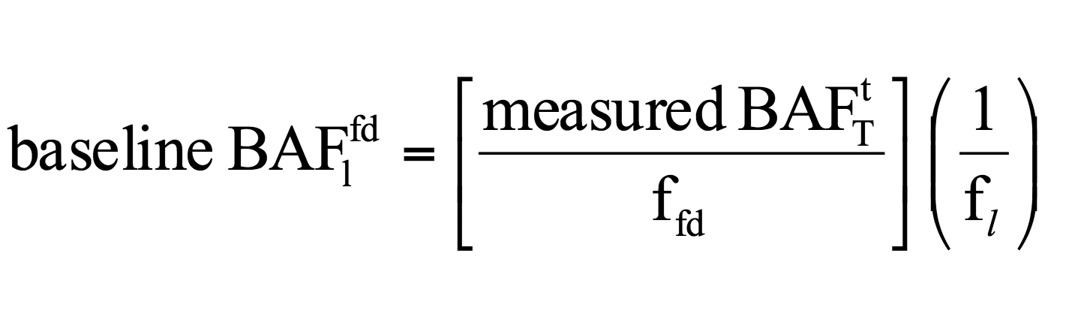
| where: | baseline BAF1fd = BAF expressed on a freely dissolved and lipid-normalized basis (L/kg) |
| f1 = fraction of the tissue that is lipid | |
| ffd = fraction of the total chemical that is freely dissolved in ambient surface water |
The freely dissolved fraction or ffd is the portion of the nonionic organic chemical that is not bound to particulate organic carbon or dissolved organic carbon and is calculated:
| 1 | |||
| ffd | = | _ | |
| [1 + (POC x KOW) + (DOC x 0.08 x KOW)] |
| where: | POC = concentration of particulate organic carbon (kg/L) |
| DOC = concentration of dissolved organic carbon (kg/L) | |
| KOW = n-octanol water partition coefficient for the chemical |
POC and DOC concentrations are obtained from the original study from which the field-measured BAF is determined. If POC and DOC concentrations are not reported in the BAF study, reliable estimates of POC and DOC are obtained from other studies at closely related sites within the same water body. If no study data are available, the USEPA national default DOC and POC values are used, as they are representative of average ambient surface water conditions. The USEPA national default values are DOC of 2.9 mg/L and POC of 0.5 mg/L, converted to kg/L by dividing by 1,000,000.
For the field-measured BAF for a chemical classified as inorganic and organometallic, the field BAF is equal to the baseline BAF and is not expressed on a lipid or freely dissolved fraction basis. Normalization on other characteristics must be supported by chemical-specific data.
B.
Method 2: Field BSAF. For nonionic organic chemicals, the field-measured BSAF is determined by relating lipid-normalized concentration of the chemical in the appropriate tissue of the aquatic organism to organic carbon-normalized concentrations of the chemical in surface sediment.
| Cl | ||
| BSAF | = | _ |
| Csoc |
| where: | BSAF = biota-sediment accumulation factor for the chemical (kg of sediment organic carbon/kg of lipid) |
| C1 = lipid-normalized concentration of the chemical in the specified wet tissue (µg/g lipid), calculated as: |
| Ct | ||
| Cl | = | _ |
| fl |
| where: | f1 = fraction lipid content in the tissue |
| Other variables as defined under item A | |
| Csoc = organic-carbon normalized concentration of a chemical in surface sediment samples (µg/g sediment organic carbon), calculated as: |
| Cs | ||
| Csoc | = | _ |
| foc |
| where: | Cs = concentration of chemical in dry sediment (µg/g sediment) |
| foc = fraction organic carbon in dry sediment |
The measured BSAF is converted to a baseline BAF or BAF1fd by the following equation:
| (Πsocw)r (Di/r) (KOW)i | |||
| (baseline BAF1fd)i | = | (BSAF)i | _ |
| (Kow)r |
| where: | (baseline BAF1fd)i = BAF expressed on a freely dissolved and lipid-normalized basis for chemical of interest "i" or the chemical that is the basis of the criteria (L/kg) |
| BSAFi = measured BSAF for the chemical "i" (kg organic carbon/kg of lipid) | |
| (Πsocw)r = sediment to water partition coefficient or sediment organic carbon to freely dissolved concentration ratio of the reference chemical "r." Reference chemicals with (Πsocw)r/(Kow) similar to that of the chemical of interest are preferred for this method (L/kg sediment organic carbon) |
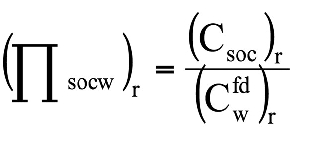
| where: | (Csoc)r = concentration of the reference chemical "r" in dry sediment normalized to sediment organic carbon (µg/kg sediment organic carbon) |
| (Cfdw)r = concentration of the reference chemical "r" freely dissolved in water (µg/L) | |
| (Di/r) = ratio between Πsocw/Kow for chemicals "i" and reference chemical "r"; a ratio equal to or close to one is preferred | |
| (Kow)i = octanol-water partition coefficient for the chemical "i" | |
| (Kow)r = octanol-water partition coefficient for the reference chemical "r" | |
| Other variables as defined under item A |
C.
Method 3: Lab BCF*FCM. The laboratory-measured BCF for nonionic organic chemicals is calculated based on the total concentration of the chemical in the appropriate tissue of the aquatic organism (on a wet tissue basis) and the total concentration of chemical in the study water (BCFtT).
| Ct | ||
| measured BCFtT | = | _ |
| Cw |
| where: | Cw = total concentration of chemical in the laboratory test water (µg/L) |
| Other variables as defined under item A | |
| Baseline BAF1fd equation: |
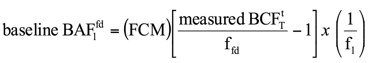
| where: | ffd = fraction of the total chemical in the test water that is freely dissolved, where POC and DOC or reasonable estimates based on total organic carbon (TOC) values measured in the test water are used, unless not available, then the following defaults are used based on typical lab water characteristics: DOC of 2.5 mg/L and POC at 0 mg/L, converted to kg/L by dividing by 1,000,000 |
| FCM = food chain multiplier | |
| Other variables as defined under item A |
For ionic organic, inorganic, and organometallic chemicals, based on available data, the laboratory BCF is equal to the baseline BAF and is not expressed on a lipid or freely dissolved fraction basis. Normalization on other characteristics must be supported by chemical-specific data. FCM must come from field BAF studies.
D.
Method 4: Kow*FCM. In this method, Kow is assumed to be equal to the baseline BAF1fd for certain nonionic organic chemicals described in the procedures.
| baseline BAF1fd = (FCM) x (Kow) |
| where: | Variables as defined under items A and C |
Subp. 9.
Hierarchy of acceptable baseline BAF methods.
Determine the hierarchy of acceptable baseline BAF methods available under subpart 8 for appropriate use based on the chemical categorization of the pollutant and other relevant properties as described under Procedures 1 to 6.
A.
Procedures 1 to 6 are used for defining the hierarchy and use of the four baseline BAF methods based on chemical categorization and a chemical's ionization state in ambient surface waters, hydrophobicity, biomagnification, and metabolism in aquatic organisms, primarily freshwater fish species. Table 1 provides the basic information for identifying the acceptable procedures and hierarchy for baseline BAF methods as described under items B to D:
| Table 1. | |||||
| Chemical Categorization | |||||
| Nonionic Organic and Ionic (negligible ionization) Organic Chemicals |
Inorganic, Organometallic, and Ionic Chemicals |
||||
| Hydrophobicity | Biomagnification Factor (BMF) | ||||
| log Kow ≥ 4 | log Kow < 4 | BMF ≤ 1,000 | BMF > 1,000 | ||
| Metabolism in Aquatic Organisms (Fish) | |||||
| Low or Unknown | High | Low or Unknown | High | ||
| Procedures: | |||||
| Procedure 1 | Procedure 2 | Procedure 3 | Procedure 4 | Procedure 5 | Procedure 6 |
| 1) Field BAF 2) Field BSAF 3) Lab BCF*FCM 4) Kow*FCM |
1) Field BAF 2) Field BSAF 3) Lab BCF |
1) Field BAF or Lab BCF 2) Kow |
Field BAF or Lab BCF |
Field BAF or Lab BCF |
1) Field BAF 2) Lab BCF*FCM |
B.
For nonionic (neutral) organic chemicals, defined as chemicals that have no or negligible ionization in ambient surface water, Procedures 1 to 4 describe the hierarchy of acceptable baseline BAF methods to use.
(1)
Procedure 1 applies to nonionic organic chemicals with moderate to high hydrophobicity defined as log Kow greater than or equal to (≥) 4 and either a low level of documented metabolism in aquatic organisms or lack of sufficient data to characterize metabolism. All four baseline BAF methods are available for use based on the stated hierarchy in Table 1 and availability of acceptable data.
(2)
Procedure 2 applies to nonionic organic chemicals with moderate to high hydrophobicity defined as log Kow ≥ 4 and a high level of documented metabolism in aquatic organisms. The acceptable methods are field BAF, BSAF, and lab BCF*FCM, where FCM is equal to one.
(3)
Procedure 3 applies to nonionic organic chemicals with low hydrophobicity defined as log Kow less than (<) 4 and either a low level of documented metabolism in aquatic organisms or lack of sufficient data to characterize metabolism. The acceptable methods are field BAF or lab BCF*FCM, with equal preference given, and Kow*FCM, where FCM is equal to one in both methods.
(4)
Procedure 4 applies to nonionic organic chemicals with low hydrophobicity defined as log Kow < 4 and high levels of documented metabolism in aquatic organisms. Equal preference is given to both acceptable methods: field BAF or lab BCF*FCM, where FCM is equal to one.
C.
For ionic organic chemicals (defined as chemicals that can readily accept or donate protons) the procedures that define the available hierarchy and appropriate baseline BAF methods depend on further characteristics of the chemical. The main characteristics relate to exhibiting primarily nonionic (neutral) characteristics (ionization is negligible) or ionic characteristic in average surface water pH ranges based on its acid dissociation constant (Ka) expressed as the negative base 10 log (pKa) and functional group or groups:
(1)
When ionization is negligible, the chemical is categorized as a nonionic organic chemical and baseline BAF procedures are applied based on hydrophobicity and metabolism characteristics described for Procedures 1 to 4 under item B, subitems (1) to (4).
(2)
In all other cases, the chemical is categorized with inorganic and organometallic chemicals and addressed with Procedure 5 or 6 under item D, subitem (1) or (2).
Available chemical-specific data that supports more defensible baseline BAF methods must be used in place of these default assignments.
D.
Inorganic and organometallic chemicals are defined as inorganic minerals, other inorganic chemicals, and elements: metals and metalloids and organometallic chemicals, and Procedures 5 and 6 define the use of acceptable baseline BAF methods. Procedures 5 and 6 are distinguished by the determination of whether the chemical demonstrates biomagnifications through field BAF or laboratory BCF studies, with BAF or BMF greater than 1,000 being the cut-off for this purpose. BMF is calculated using chemical concentrations in the tissue of aquatic organisms at two successive trophic levels as:
| BMF(TL, n) = Ct (TL, n) / Ct (TL, n-1) |
| where: | Ct (TL, n) = total concentration of relevant chemical form or forms in appropriate tissue of predator organism at trophic level "n" (may be either wet weight or dry weight concentration so long as both the predator and prey concentrations are expressed in the same manner) (µg/kg) |
| Ct (TL, n-1) = total concentration of relevant chemical form or forms in appropriate tissue of prey organism at the next lower trophic level from the predator (may be either wet weight or dry weight concentration so long as both the predator and prey concentrations are expressed in the same manner) (µg/kg) |
(1)
Procedure 5 applies when geometric mean BAF or BMF is less than or equal to 1,000 when comparing successive trophic level ratios up through trophic level 4. Equal preference is given to field BAF or lab BCF*FCM, where FCM is equal to one. For this procedure, field BAF or lab BCF is applied as the baseline BAF.
| measured BAFtT = Ct/Cw | or | BCFtT = Ct/Cw | are applied as the baseline BAF. | |
| where: | Variables as defined under subpart 8 |
(2)
Procedure 6 applies when geometric mean BAF or BMF is greater than 1,000 when comparing successive trophic level ratios up through trophic level 4. The acceptable methods are field BAF or lab BCF*FCM, with preference for field BAF. For this procedure, field BAF or lab BCF is applied as the baseline BAF.
| measured BAFtT = Ct/Cw | or | BCFtT = Ct/Cw | are applied as the baseline BAF. | |
| where: | Variables as defined under subpart 8 |
Subp. 10.
Species mean baseline BAF.
Calculate species and mean baseline BAF from acceptable individual baseline BAF.
A.
For each appropriate baseline BAF method, calculate species-mean baseline BAF using the geometric mean.
B.
Any baseline BAF with large differences between species (greater than ten percent) needs additional justification for use in a species-mean baseline BAF.
C.
Evaluate data uncertainties for consideration in method hierarchy application for calculating trophic level baseline BAF.
Subp. 11.
Final baseline BAF by trophic level.
Determine the final baseline BAF by trophic level (TL):
A.
Calculate geometric mean baseline BAF for TL3 and TL4 using available species-means for each baseline BAF method. For Class 2A water, preference is given for Salmonidae data and developed as a single representative TL4 baseline BAF for cold-water aquatic communities.
B.
Combine species-means for methods that have equal preference in procedural hierarchies and have similarly reliable baseline BAF based on evaluation of data uncertainties for a final baseline BAF for TL3 where applicable, and final baseline BAF for TL4.
C.
For some pollutants, TL3 and TL4 baseline BAF may be identical when not dependent on trophic level factors, such as lipid partitioning.
Subp. 12.
Final state or site BAF by trophic level.
Calculate final state or site BAF for TL3 where applicable and TL4 for use in developing human health-based chronic criteria or standards.
A.
For nonionic organic chemicals and ionic organic chemicals with no or negligible ionization as defined under subpart 7, for each TL3 and TL4, calculate a state or site BAF using the following equation:

| where: | (final baseline BAFlfd)TL n = final trophic-level-mean baseline BAF expressed on a freely dissolved and lipid-normalized basis for trophic level "n" (L/kg) |
| (fl)TL n = lipid fraction of aquatic species consumed at trophic level "n" by Class 2 subclass: Class 2A = 0.06; Class 2Bd/2B/2C/2D = 0.02 for TL3 and 0.015 for TL4 | |
| ffd = fraction of the total chemical in water that is freely dissolved in ambient waters | |
The default DOC and POC values for the state ambient Class 2 surface waters are 7.5 x 10⁻⁶ kg/L (7.5 mg/L) and 5 x 10⁻⁷ kg/L (0.5 mg/L), respectively. For a site BAF for use in site-specific criteria development, the DOC and POC values are from the site monitoring data, if available; in all other cases, the state defaults are used.
B.
For inorganic and organometallic chemicals and ionic organic chemicals with ionization in natural waters, the baseline BAFtT using total chemical concentrations or bioavailable forms are directly applied as the state or site BAF:
| state BAF(TL n) or site BAF | = | final baseline BAF(TL n) |
Subp. 13.
Algorithms for Class 2A or 2Bd surface waters.
This subpart describes human health-based criteria or standards for classes of surface waters designated for drinking water, fish consumption, and recreational use. To develop a final chronic criteria (CCdfr) or standard (CSdfr) applicable to surface waters designated Class 2A or 2Bd, items A to D must be evaluated for use based on the pollutant's toxicological profile: noncarcinogen or nonlinear carcinogen (NLC); developmental susceptibility; or linear carcinogen (C).
A.
Algorithm for noncarcinogenic or NLC chemicals applicable to surface waters designated Class 2A or 2Bd to calculate: CCdfr or CSdfr=
| RfDchronic (mg/kg-d) x RSC (no units) x 1,000 µg/mg |
| _ |
| {DWIRchronic (L/kg-d) + FCRadult (kg/kg-d)[(0.24 x BAFTL3 (L/kg)) + (0.76 x BAFTL4 (L/kg)]} |
| where: | CCdfr or CSdfr = drinking water plus fish consumption and recreation chronic criterion or standard in µg/L |
| RfDchronic = reference dose for chronic duration in mg/kg-day | |
| RSC = relative source contribution factor | |
| 1,000 µg/mg = a factor used to convert milligram (mg) to microgram (µg); | |
| there are 1,000 micrograms per milligram | |
| DWIRchronic = drinking water intake rate for the chronic duration based on a 95th percentile time-weighted average from MDH; rate may be chemical-specific with sufficient data or use the default rate of 0.043 L/kg-d | |
| FCRadult = fish consumption intake rate of 0.00043 kg/kg-d based on 0.030 kg/day of amount of fish assumed to be consumed per day and 70 kg adult body weight or rate may be chemical-specific with sufficient data | |
| BAFTL3 = final BAF for TL3 fish in L/kg; accounts for 24 percent of fish consumed | |
| BAFTL4 = final BAF for TL4 fish in L/kg; accounts for 76 percent of fish consumed; for Class 2A, the BAFTL4 is applied to 100 percent of the FCR |
B.
Supplemental algorithm for developmental susceptibility for noncarcinogenic or NLC chemicals applicable to surface waters designated Class 2A or 2Bd to calculate: CCdev or CSdev =
| RfDduration_(acute, short-term, or subchronic) (mg/kg-d) x RSC (no units) x 1,000 µg/mg |
| _ |
| DWIRduration_(acute, short-term, or subchronic) (L/kg-d) |
| where: | CCdev or CSdev = developmental-based drinking water chronic criterion or standard in µg/L applied when shorter duration adverse effects and exposure parameters result in a more stringent chronic criterion or standard than calculated from item A |
| RfDduration = reference dose for acute, short-term, or subchronic duration in mg/kg-day | |
| DWIRduration = drinking water intake rate for acute, short-term, or subchronic duration in L/kg-d; drinking water intake rate for the acute, short-term, and subchronic durations based on a 95th percentile time-weighted average from MDH; rate may be chemical-specific with sufficient data or use default rates of 0.289, 0.289, and 0.077 L/kg-d, respectively | |
| Other variables as defined under item A |
C.
Algorithm for linear carcinogenic chemicals with lifetime adjustment factors (AFlifetime) applicable to surface waters designated Class 2A or 2Bd to calculate: CCdfror CSdfr =

| where: | CCdfr or CSdfr = drinking water plus fish consumption and recreation chronic criterion or standard in µg/L |
| CR = cancer risk level or an additional excess cancer risk equal to 1 x 10⁻⁵ (1 in 100,000) | |
| CSF = cancer potency slope factor in (mg/kg-d)-1 | |
| AFlifetime = adjustment factor, lifetime (no units) | |
| DWIRlifetime = drinking water intake rate for lifetime duration; drinking water intake rate for the lifetime duration based on a 95th percentile time-weighted average from MDH; rate may be chemical-specific with sufficient data or use default rate of 0.043 L/kg-d | |
| Other variables as defined under item A |
D.
Algorithm for linear carcinogenic chemicals with age-dependent adjustment factors (ADAF) applicable to surface waters designated Class 2A or 2Bd to calculate: CCdfr or CSdfr =
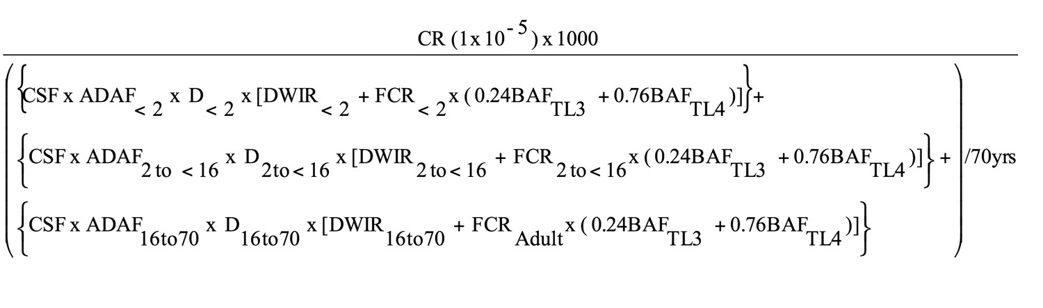
| where: | CCdfr or CSdfr = drinking water plus fish consumption and recreation chronic criterion or standard in µg/L |
| ADAF = age-dependent adjustment factor by age groups | |
| D = duration corresponding to the three age groups: birth up to two years of age (two-year duration), two years of age up to 16 years of age (14-year duration), and 16 years of age up to 70 years of age (54-year duration) | |
| DWIR = drinking water intake rate for age groups; drinking water intake rate for the lifetime duration based on a 95th percentile time-weighted average from MDH; rate may be chemical-specific with sufficient data or use default rates for: | |
| DWIR0<2 = 0.137 L/kg-d, birth up to two years of age | |
| DWIR2 to < 16 = 0.047 L/kg-d, two up to 16 years of age | |
| DWIR16 to 70 = 0.039 L/kg-d, 16 up to 70 years of age | |
| FCR = fish consumption intake rate by age groups: | |
| FCR0<2 = 0.00086 kg/kg-d | |
| FCR2 to < 16 = 0.00055 kg/kg-d | |
| FCR16 to 70 = 0.00043 kg/kg-d |
Subp. 14.
Algorithm for Class 2B, 2C, or 2D surface waters.
This subpart describes human health-based criteria or standards for classes of surface waters designated for fish consumption and recreational use (nondrinking water use). To develop a final chronic criteria (CCfr) or standard (CSfr) applicable to surface waters designated Class 2B, 2C, or 2D, items A to C must be evaluated for use based on the pollutant's toxicological profile: noncarcinogen or nonlinear carcinogen (NLC) or linear carcinogen (C).
A.
Algorithm for noncarcinogenic or NLC chemicals applicable to Class 2B, 2C, or 2D surface waters to calculate: CCfr or CSfr =
| RfDchronic (mg/kg-d) x RSC (no units) x 1,000 µg/mg |
| _ |
| {IWRchronic (L/kg-d) + FCRadult (kg/kg-d)[(0.24 x BAFTL3 (L/kg)) + (0.76 x BAFTL4 (L/kg)]} |
| where: | CCfr or CSfr = fish consumption and recreation chronic criterion or standard in µg/L |
| IWRchronic = 0.0013 L/kg-d; assumed incidental water intake rate based on minimum chronic duration | |
| Other variables as defined under subpart 13 |
B.
Algorithm for linear carcinogenic chemicals with lifetime adjustment factors (AFlifetime) applicable to surface waters designated Class 2B, 2C, or 2D to calculate: CCfror CSfr =

| where: | CCfr or CSfr = fish consumption and recreation chronic criterion or standard in µg/L |
| Other variables as defined under item A and subpart 13 |
C.
Algorithm for linear carcinogenic chemicals with age-dependent adjustment factors (ADAF) applicable to surface waters designated Class 2B, 2C, or 2D to calculate: CCfr or CSfr =
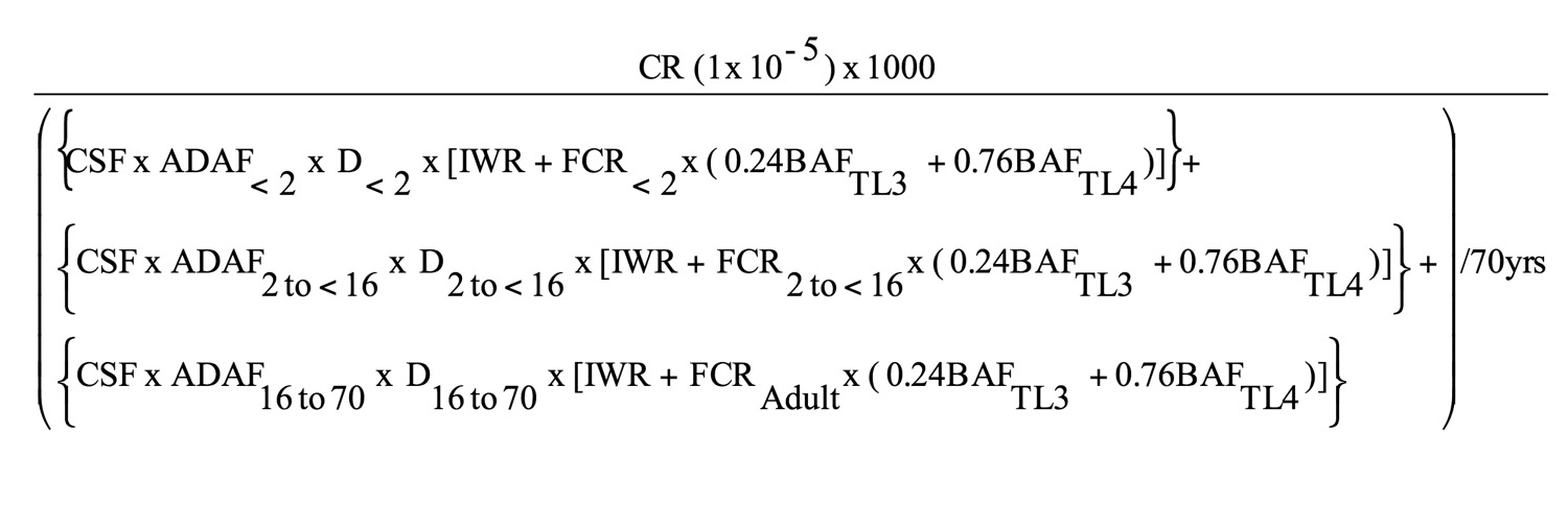
| where: | CCfr or CSfr = fish consumption and recreation chronic criterion or standard in µg/L |
| Other variables as defined under item A and subpart 13 |
Subp. 15.
Algorithms for Class 2 fish tissue.
This subpart describes algorithms and fish tissue criteria (CCft) and standards (CSft) for chemical with BAF greater than 1,000 (BCC threshold) applicable to Class 2 surface waters. Items A to C must be evaluated for use based on the pollutant's toxicological profile: noncarcinogen or nonlinear carcinogen (NLC) or linear carcinogen (C).
A.
Algorithm for noncarcinogenic or NLC chemicals applicable to Class 2 surface waters to calculate: CCft or CSft =
| RfDchronic (mg/kg-d) x RSC (no units) or - RSC (mg/kg-d) |
| _ |
| FCRadult (kg/kg-d) |
| where: | CCft or CSft = fish tissue-based chronic criterion or standard in mg/kg |
| Other variables as defined under subpart 13 |
B.
Algorithm for linear carcinogenic chemicals with lifetime adjustment factors (AFlifetime) applicable to Class 2 surface waters to calculate: CCft or CSft =
| CR (1 x 10⁻⁵) | 1 | ||
| _ | x | _ | |
| CSF (mg/kg-d)-1 x AFlifetime (no units) | FCRAdult (kg/kg-d) |
| where: | CCft or CSft = fish tissue-based chronic criterion or standard in mg/kg |
| Other variables as defined under subpart 13 |
C.
Algorithm for linear carcinogenic chemicals with age-dependent adjustment factors (ADAFs) applicable to Class 2 surface waters to calculate: CCft or CSft =

| where: | CCft or CSft = fish tissue-based chronic criterion or standard in mg/kg |
| Other variables as defined under subpart 13 |
History:
39 SR 1344
Published Electronically:
March 24, 2015
7050.0220 SPECIFIC WATER QUALITY STANDARDS BY ASSOCIATED USE CLASSES.
Subpart 1.
Purpose and scope.
The numeric and narrative water quality standards in this chapter prescribe the qualities or properties of the waters of the state that are necessary for the designated public uses and benefits. If the standards in this chapter are exceeded, it is considered indicative of a polluted condition which is actually or potentially deleterious, harmful, detrimental, or injurious with respect to designated uses or established classes of the waters of the state.
All surface waters are protected for multiple beneficial uses. Numeric water quality standards are tabulated in this part for all uses applicable to four common categories of surface waters, so that all applicable standards for each category are listed together in subparts 3a to 6a. The four categories are:
A.
cold water sport fish (trout waters), also protected for drinking water: Classes 1B, 2A, 3A or 3B, 4A and 4B, and 5 (subpart 3a);
B.
cool and warm water sport fish, also protected for drinking water: Classes 1B or 1C, 2Bd, 3A or 3B, 4A and 4B, and 5 (subpart 4a);
C.
cool and warm water sport fish, indigenous aquatic life, and wetlands: Classes 2B, 2C, or 2D; 3A, 3B, 3C, or 3D; 4A and 4B or 4C; and 5 (subpart 5a); and
Subp. 2.
Explanation of tables.
A.
Class 1 domestic consumption (DC) standards are the United States Environmental Protection Agency primary (maximum contaminant levels) and secondary drinking water standards, as contained in Code of Federal Regulations, title 40, parts 141 and 143, as amended through July 1, 2006. The DC standards are listed in subparts 3a and 4a, except that individual pollutants, substances, or organisms in the treatment technological, disinfectants, microbiological, and radiological categories are not listed unless they are listed because a secondary drinking water standard or a standard for another use class exists.
B.
Certain drinking water standards are not applicable to Class 1 waters. The following are not applicable to Class 1 surface waters: the primary drinking water standards for acrylamide, epichlorohydrin, copper, lead, and turbidity (treatment technique standards) and the standards in the disinfectants and microbiological organisms categories. The drinking water standards not applicable to Class 1 ground waters are listed in part 7050.0221.
C.
Class 2 standards for metals are expressed as total metal in subparts 3a to 5a, but must be converted to dissolved metal standards for application to surface waters. Conversion factors for converting total metal standards to dissolved metal standards are listed in part 7050.0222, subpart 9. The conversion factor for metals not listed in part 7050.0222, subpart 9, is one. The dissolved metal standard equals the total metal standard times the conversion factor. Water quality-based effluent limits for metals are expressed as total metal.
D.
The tables of standards in subparts 3a to 6a include the following abbreviations and acronyms:
| AN | means aesthetic enjoyment and navigation, Class 5 waters |
| * | an asterisk following the FAV and MS values or double dashes (–) means part 7050.0222, subpart 7, item G, applies |
| (c) | means the chemical is assumed to be a human carcinoge |
| CS | means chronic standard, defined in part 7050.0218, subpart 3 |
| DC | means domestic consumption (drinking water), Class 1 waters |
| – | double dashes means there is no standard |
| exp. () | means the natural antilogarithm (base e) of the expression in parenthesis |
| FAV | means final acute value, defined in part 7050.0218, subpart 3 |
| IC | means industrial consumption, Class 3 waters |
| IR | means agriculture irrigation use, Class 4A waters |
| LS | means agriculture livestock and wildlife use, Class 4B waters |
| MS | means maximum standard, defined in part 7050.0218, subpart 3 |
| NA | means not applicable |
| (S) | means the associated value is a secondary drinking water standard |
| su | means standard unit. It is the reporting unit for pH |
| TH | means total hardness in mg/L, which is the sum of the calcium and magnesium concentrations expressed as CaCO3 |
| TON | means threshold odor number |
E.
Important synonyms or acronyms for some chemicals are listed in parentheses below the primary name.
Subp. 3a.
Cold water sport fish, drinking water, and associated use classes.
Water quality standards applicable to use Classes 1B, 2A, 3A or 3B, 4A and 4B, and 5 surface waters.
A. MISCELLANEOUS SUBSTANCE, CHARACTERISTIC, OR POLLUTANT
|
2A
CS |
2A
MS |
2A
FAV |
1B
DC |
3A/3B
IC |
4A
IR |
4B
IR |
5
AN |
|
| _ | ||||||||
(1) Ammonia, un-ionized as N, μg/L
| 16 | -- | -- | -- | -- | -- | -- | -- |
(2) Asbestos, >10 μm (c), fibers/L
| -- | -- | -- | 7.0e+06 | -- | -- | -- | -- |
(3) Bicarbonates (HCO3), meq/L
| -- | -- | -- | -- | -- | 5 | -- | -- |
(4) Bromate, μg/L
| -- | -- | -- | 10 | -- | -- | -- | -- |
(5) Chloride, mg/L
| 230 | 860 | 1,720 | 250(S) | 50/100 | -- | -- | -- |
|
2A
CS |
2A
MS |
2A
FAV |
1B
DC |
3A/3B
IC |
4A
IR |
4B
IR |
5
AN |
|
| _ | ||||||||
(6) Chlorine, total residual, μg/L
| 11 | 19 | 38 | -- | -- | -- | -- | -- |
(7) Chlorite, μg/L
| -- | -- | -- | 1,000 | -- | -- | -- | -- |
(8) Color, Pt-Co
| 30 | -- | -- | 15(S) | -- | -- | -- | -- |
(9) Cyanide, free, μg/L
| 5.2 | 22 | 45 | 200 | -- | -- | -- | -- |
(10) Escherichia (E.) coli bacteria, organisms/100 mL
| See item D |
-- | -- | -- | -- | -- | -- | -- |
|
2A
CS |
2A
MS |
2A
FAV |
1B
DC |
3A/3B
IC |
4A
IR |
4B
IR |
5
AN |
|
| _ | ||||||||
(11) Eutrophication standards for lakes and reservoirs (phosphorus, total, μg/L; chlorophyll-a, μg/L; Secchi disk transparency, meters)
| See part 7050.0222, subparts 2 and 2a | -- | -- | -- | -- | -- | -- | -- |
(12) Eutrophication standards for rivers, streams, and navigational pools (phosphorus, total μg/L; chlorophyll-a (seston), μg/L; five-day biochemical oxygen demand (BOD5), mg/L; diel dissolved oxygen flux, mg/L; chlorophyll-a (periphyton), mg/m2)
| See part 7050.0222, subparts 2 and 2b | -- | -- | -- | -- | -- | -- | -- |
(13) Fluoride, mg/L
| -- | -- | -- | 4 | -- | -- | -- | -- |
(14) Fluoride, mg/L
| -- | -- | -- | 2(S) | -- | -- | -- | -- |
(15) Foaming agents, μg/L
| -- | -- | -- | 500(S) | -- | -- | -- | -- |
(16) Hardness, Ca+Mg as CaCO3, mg/L
| -- | -- | -- | -- | 50/250 | -- | -- | -- |
|
2A
CS |
2A
MS |
2A
FAV |
1B
DC |
3A/3B
IC |
4A
IR |
4B
IR |
5
AN |
|
| _ | ||||||||
(17) Hydrogen sulfide, mg/L
| -- | -- | -- | -- | -- | -- | -- | 0.02 |
(18) Nitrate as N, mg/L
| -- | -- | -- | 10 | -- | -- | -- | -- |
(19) Nitrite as N, mg/L
| -- | -- | -- | 1 | -- | -- | -- | -- |
(20) Nitrate + Nitrite as N, mg/L
| -- | -- | -- | 10 | -- | -- | -- | -- |
(21) Odor, TON
| -- | -- | -- | 3(S) | -- | -- | -- | -- |
|
2A
CS |
2A
MS |
2A
FAV |
1B
DC |
3A/3B
IC |
4A
IR |
4B
IR |
5
AN |
|
| _ | ||||||||
(22) Oil, μg/L
| 500 | 5,000 | 10,000 | -- | -- | -- | -- | -- |
(23) Oxygen, dissolved, mg/L
| 7, as a daily minimum |
-- | -- | -- | -- | -- | -- | -- |
(24) pH minimum, su
| 6.5 | -- | -- | 6.5(S) | 6.5/6.0 | 6.0 | 6.0 | 6.0 |
(25) pH maximum, su
| 8.5 | -- | -- | 8.5(S) | 8.5/9.0 | 8.5 | 9.0 | 9.0 |
(26) Radioactive materials
| See item E |
-- | -- | See item E |
-- | See item E |
See item E |
-- |
|
2A
CS |
2A
MS |
2A
FAV |
1B
DC |
3A/3B
IC |
4A
IR |
4B
IR |
5
AN |
|
| _ | ||||||||
(27) Salinity, total, mg/L
| -- | -- | -- | -- | -- | -- | 1,000 | -- |
(28) Sodium, meq/L
| -- | -- | -- | -- | -- | 60% of total cations |
-- | -- |
(29) Specific conductance at 25°C, μmhos/cm
| -- | -- | -- | -- | -- | 1,000 | -- | -- |
(30) Sulfate, mg/L
| -- | -- | -- | 250(S) | -- | -- | -- | -- |
(31) Sulfates, wild rice present, mg/L
| -- | -- | -- | -- | -- | 10 | -- | -- |
|
2A
CS |
2A
MS |
2A
FAV |
1B
DC |
3A/3B
IC |
4A
IR |
4B
IR |
5
AN |
|
| _ | ||||||||
(32) Temperature, °F
| No material increase |
-- | -- | -- | -- | -- | -- | -- |
(33) Total dissolved salts, mg/L
| -- | -- | -- | -- | -- | 700 | -- | -- |
(34) Total dissolved solids, mg/L
| -- | -- | -- | 500(S) | -- | -- | -- | -- |
(35) Total suspended solids (TSS), mg/L
| See part 7050.0222, subpart 2 | -- | -- | -- | -- | -- | -- | -- |
B. METALS AND ELEMENTS
|
2A
CS |
2A
MS |
2A
FAV |
1B
DC |
3A/3B
IC |
4A
IR |
4B
LS |
5
AN |
|
| _ | ||||||||
(1) Aluminum, total, μg/L
| 87 | 748 | 1,496 | 50- 200(S) |
-- | -- | -- | -- |
(2) Antimony, total, μg/L
| 5.5 | 90 | 180 | 6 | -- | -- | -- | -- |
(3) Arsenic, total, μg/L
| 2.0 | 360 | 720 | 10 | -- | -- | -- | -- |
(4) Barium, total, μg/L
| -- | -- | -- | 2,000 | -- | -- | -- | -- |
(5) Beryllium, total, μg/L
| -- | -- | -- | 4.0 | -- | -- | -- | -- |
|
2A
CS |
2A
MS |
2A
FAV |
1B
DC |
3A/3B
IC |
4A
IR |
4B
LS |
5
AN |
|
| _ | ||||||||
(6) Boron, total, μg/L
| -- | -- | -- | -- | -- | 500 | -- | -- |
(7) Cadmium, total, μg/L
| 1.1 | 3.9 | 7.8 | 5 | -- | -- | -- | -- |
Class 2A cadmium standards are hardness dependent. Cadmium values shown are for a total hardness of 100 mg/L only. See part 7050.0222, subpart 2, for examples at other hardness values and equations to calculate cadmium standards for any hardness value not to exceed 400 mg/L.
(8) Chromium +3, total, μg/L
| 207 | 1,737 | 3,469 | -- | -- | -- | -- | -- |
Class 2A trivalent chromium standards are hardness dependent. Chromium +3 values shown are for a total hardness of 100 mg/L only. See part 7050.0222, subpart 2, for examples at other hardness values and equations to calculate trivalent chromium standards for any hardness value not to exceed 400 mg/L.
(9) Chromium +6, total, μg/L
| 11 | 16 | 32 | -- | -- | -- | -- | -- |
(10) Chromium, total, μg/L
| -- | -- | -- | 100 | -- | -- | -- | -- |
|
2A
CS |
2A
MS |
2A
FAV |
1B
DC |
3A/3B
IC |
4A
IR |
4B
LS |
5
AN |
|
| _ | ||||||||
(11) Cobalt, total, μg/L
| 2.8 | 436 | 872 | -- | -- | -- | -- | -- |
(12) Copper, total, μg/L
| 9.8 | 18 | 35 | 1,000 (S) |
-- | -- | -- | -- |
Class 2A copper standards are hardness dependent. Copper values shown are for a total hardness of 100 mg/L only. See part 7050.0222, subpart 2, for examples at other hardness values and equations to calculate copper standards for any hardness value not to exceed 400 mg/L.
(13) Iron, total, μg/L
| -- | -- | -- | 300(S) | -- | -- | -- | -- |
(14) Lead, total, μg/L
| 3.2 | 82 | 164 | NA | -- | -- | -- | -- |
Class 2A lead standards are hardness dependent. Lead values shown are for a total hardness of 100 mg/L only. See part 7050.0222, subpart 2, for examples at other hardness values and equations to calculate lead standards for any hardness value not to exceed 400 mg/L.
(15) Manganese, total, μg/L
| -- | -- | -- | 50(S) | -- | -- | -- | -- |
|
2A
CS |
2A
MS |
2A
FAV |
1B
DC |
3A/3B
IC |
4A
IR |
4B
LS |
5
AN |
|
| _ | ||||||||
(16) Mercury, total, in water, ng/L
| 6.9 | 2,400* | 4,900* | 2,000 | -- | -- | -- | -- |
(17) Mercury, total in edible fish tissue, mg/kg or parts per million
| 0.2 | -- | -- | -- | -- | -- | -- | -- |
(18) Nickel, total, μg/L
| 158 | 1,418 | 2,836 | -- | -- | -- | -- | -- |
Class 2A nickel standards are hardness dependent. Nickel values shown are for a total hardness of 100 mg/L only. See part 7050.0222, subpart 2, for examples at other hardness values and equations to calculate nickel standards for any hardness value not to exceed 400 mg/L.
(19) Selenium, total, μg/L
| 5.0 | 20 | 40 | 50 | -- | -- | -- | -- |
(20) Silver, total, μg/L
| 0.12 | 2.0 | 4.1 | 100(S) | -- | -- | -- | -- |
Class 2A silver MS and FAV are hardness dependent. Silver values shown are for a total hardness of 100 mg/L only. See part 7050.0222, subpart 2, for examples at other hardness values and equations to calculate silver standards for any hardness value not to exceed 400 mg/L.
|
2A
CS |
2A
MS |
2A
FAV |
1B
DC |
3A/3B
IC |
4A
IR |
4B
LS |
5
AN |
|
| _ | ||||||||
(21) Thallium, total, μg/L
| 0.28 | 64 | 128 | 2 | -- | -- | -- | -- |
(22) Zinc, total, μg/L
| 106 | 117 | 234 | 5,000 (S) |
-- | -- | -- | -- |
Class 2A zinc standards are hardness dependent. Zinc values shown are for a total hardness of 100 mg/L only. See part 7050.0222, subpart 2, for examples at other hardness values and equations to calculate zinc standards for any hardness value not to exceed 400 mg/L.
C. ORGANIC POLLUTANTS OR CHARACTERISTICS
|
2A
CS |
2A
MS |
2A
FAV |
1B
DC |
3A/3B
IC |
4A
IR |
4B
LS |
5
AN |
|
| _ | ||||||||
(1) Acenaphthene, μg/L
| 20 | 56 | 112 | -- | -- | -- | -- | -- |
(2) Acetochlor, μg/L
| 3.6 | 86 | 173 | -- | -- | -- | -- | -- |
(3) Acrylonitrile (c), μg/L
| 0.38 | 1,140* | 2,281* | -- | -- | -- | -- | -- |
(4) Alachlor (c), μg/L
| 3.8 | 800* | 1,600* | 2 | -- | -- | -- | -- |
(5) Aldicarb, μg/L
| -- | -- | -- | 3 | -- | -- | -- | -- |
|
2A
CS |
2A
MS |
2A
FAV |
1B
DC |
3A/3B
IC |
4A
IR |
4B
LS |
5
AN |
|
| _ | ||||||||
(6) Aldicarb sulfone, μg/L
| -- | -- | -- | 2 | -- | -- | -- | -- |
(7) Aldicarb sulfoxide, μg/L
| -- | -- | -- | 4 | -- | -- | -- | -- |
(8) Anthracene, μg/L
| 0.035 | 0.32 | 0.63 | -- | -- | -- | -- | -- |
(9) Atrazine (c), μg/L
| 3.4 | 323 | 645 | 3 | -- | -- | -- | -- |
(10) Benzene (c), μg/L
| 5.1 | 4,487* | 8,974* | 5 | -- | -- | -- | -- |
|
2A
CS |
2A
MS |
2A
FAV |
1B
DC |
3A/3B
IC |
4A
IR |
4B
LS |
5
AN |
|
| _ | ||||||||
(11) Benzo(a)pyrene, μg/L
| -- | -- | -- | 0.2 | -- | -- | -- | -- |
(12) Bromoform, μg/L
| 33 | 2,900 | 5,800 | See sub- item (73) |
-- | -- | -- | -- |
(13) Carbofuran, μg/L
| -- | -- | -- | 40 | -- | -- | -- | -- |
(14) Carbon tetrachloride (c), μg/L
| 1.9 | 1,750* | 3,500* | 5 | -- | -- | -- | -- |
(15) Chlordane (c), ng/L
| 0.073 | 1,200* | 2,400* | 2,000 | -- | -- | -- | -- |
|
2A
CS |
2A
MS |
2A
FAV |
1B
DC |
3A/3B
IC |
4A
IR |
4B
LS |
5
AN |
|
| _ | ||||||||
(16) Chlorobenzene, μg/L (Monochlorobenzene)
| 20 | 423 | 846 | 100 | -- | -- | -- | -- |
(17) Chloroform (c), μg/L
| 53 | 1,392 | 2,784 | See sub- item (73) |
-- | -- | -- | -- |
(18) Chlorpyrifos, μg/L
| 0.041 | 0.083 | 0.17 | -- | -- | -- | -- | -- |
(19) Dalapon, μg/L
| -- | -- | -- | 200 | -- | -- | -- | -- |
(20) DDT (c), ng/L
| 0.11 | 550* | 1,100* | -- | -- | -- | -- | -- |
|
2A
CS |
2A
MS |
2A
FAV |
1B
DC |
3A/3B
IC |
4A
IR |
4B
LS |
5
AN |
|
| _ | ||||||||
(21) 1,2-Dibromo-3-chloropropane (c), μg/L
| -- | -- | -- | 0.2 | -- | -- | -- | -- |
(22) Dichlorobenzene (ortho), μg/L
| -- | -- | -- | 600 | -- | -- | -- | -- |
(23) 1,4-Dichlorobenzene (para) (c), μg/L
| -- | -- | -- | 75 | -- | -- | -- | -- |
(24) 1,2-Dichloroethane (c), μg/L
| 3.5 | 45,050* | 90,100* | 5 | -- | -- | -- | -- |
(25) 1,1-Dichloroethylene, μg/L
| -- | -- | -- | 7 | -- | -- | -- | -- |
|
2A
CS |
2A
MS |
2A
FAV |
1B
DC |
3A/3B
IC |
4A
IR |
4B
LS |
5
AN |
|
| _ | ||||||||
(26) 1,2-Dichloroethylene (cis), μg/L
| -- | -- | -- | 70 | -- | -- | -- | -- |
(27) 1,2-Dichloroethylene (trans), μg/L
| -- | -- | -- | 100 | -- | -- | -- | -- |
(28) 2,4-Dichlorophenoxyacetic acid (2,4-D), μg/L
| -- | -- | -- | 70 | -- | -- | -- | -- |
(29) 1,2-Dichloropropane (c), μg/L
| -- | -- | -- | 5 | -- | -- | -- | -- |
(30) Dieldrin (c), ng/L
| 0.0065 | 1,300* | 2,500* | -- | -- | -- | -- | -- |
|
2A
CS |
2A
MS |
2A
FAV |
1B
DC |
3A/3B
IC |
4A
IR |
4B
LS |
5
AN |
|
| _ | ||||||||
(31) Di-2-ethylhexyl adipate, μg/L
| -- | -- | -- | 400 | -- | -- | -- | -- |
(32) Di-2-ethylhexyl phthalate (c), μg/L
| 1.9 | --* | --* | 6 | -- | -- | -- | -- |
(33) Di-n-Octyl phthalate, μg/L
| 30 | 825 | 1,650 | -- | -- | -- | -- | -- |
(34) Dinoseb, μg/L
| -- | -- | -- | 7 | -- | -- | -- | -- |
(35) Diquat, μg/L
| -- | -- | -- | 20 | -- | -- | -- | -- |
|
2A
CS |
2A
MS |
2A
FAV |
1B
DC |
3A/3B
IC |
4A
IR |
4B
LS |
5
AN |
|
| _ | ||||||||
(36) Endosulfan, μg/L
| 0.0076 | 0.084 | 0.17 | -- | -- | -- | -- | -- |
(37) Endothall, μg/L
| -- | -- | -- | 100 | -- | -- | -- | -- |
(38) Endrin, μg/L
| 0.0039 | 0.090 | 0.18 | 2 | -- | -- | -- | -- |
(39) Ethylbenzene (c), μg/L
| 68 | 1,859 | 3,717 | 700 | -- | -- | -- | -- |
(40) Ethylene dibromide, μg/L
| -- | -- | -- | 0.05 | -- | -- | -- | -- |
|
2A
CS |
2A
MS |
2A
FAV |
1B
DC |
3A/3B
IC |
4A
IR |
4B
LS |
5
AN |
|
| _ | ||||||||
(41) Fluoranthene, μg/L
| 1.9 | 3.5 | 6.9 | -- | -- | -- | -- | -- |
(42) Glyphosate, μg/L
| -- | -- | -- | 700 | -- | -- | -- | -- |
(43) Haloacetic acids (c), μg/L (Bromoacetic acid, Dibromoacetic acid, Dichloroacetic acid, Monochloroacetic acid, and Trichloroacetic acid)
| -- | -- | -- | 60 | -- | -- | -- | -- |
(44) Heptachlor (c), ng/L
| 0.10 | 260* | 520* | 400 | -- | -- | -- | -- |
(45) Heptachlor epoxide (c), ng/L
| 0.12 | 270* | 530* | 200 | -- | -- | -- | -- |
|
2A
CS |
2A
MS |
2A
FAV |
1B
DC |
3A/3B
IC |
4A
IR |
4B
LS |
5
AN |
|
| _ | ||||||||
(46) Hexachlorobenzene (c), ng/L
| 0.061 | --* | --* | 1,000 | -- | -- | -- | -- |
(47) Hexachlorocyclopentadiene, μg/L
| -- | -- | -- | 50 | -- | -- | -- | -- |
(48) Lindane (c), μg/L (Hexachlorocyclohexane, gamma-)
| 0.0087 | 1.0* | 2.0* | 0.2 | -- | -- | -- | -- |
(49) Methoxychlor, μg/L
| -- | -- | -- | 40 | -- | -- | -- | -- |
(50) Methylene chloride (c), μg/L (Dichloromethane)
| 45 | 13,875* | 27,749* | 5 | -- | -- | -- | -- |
|
2A
CS |
2A
MS |
2A
FAV |
1B
DC |
3A/3B
IC |
4A
IR |
4B
LS |
5
AN |
|
| _ | ||||||||
(51) Metolachlor
| 23 | 271 | 543 | -- | -- | -- | -- | -- |
(52) Naphthalene, μg/L
| 65 | 409 | 818 | -- | -- | -- | -- | -- |
(53) Oxamyl, μg/L (Vydate)
| -- | -- | -- | 200 | -- | -- | -- | -- |
(54) Parathion, μg/L
| 0.013 | 0.07 | 0.13 | -- | -- | -- | -- | -- |
(55) Pentachlorophenol, μg/L
| 0.93 | 15 | 30 | 1 | -- | -- | -- | -- |
Class 2A MS and FAV are pH dependent. Pentachlorophenol values shown are for a pH of 7.5 only. See part 7050.0222, subpart 2, for examples at other pH values and equations to calculate pentachlorophenol standards for any pH value.
|
2A
CS |
2A
MS |
2A
FAV |
1B
DC |
3A/3B
IC |
4A
IR |
4B
LS |
5
AN |
|
| _ | ||||||||
(56) Phenanthrene, μg/L
| 3.6 | 32 | 64 | -- | -- | -- | -- | -- |
(57) Phenol, μg/L
| 123 | 2,214 | 4,428 | -- | -- | -- | -- | -- |
(58) Picloram, μg/L
| -- | -- | -- | 500 | -- | -- | -- | -- |
(59) Polychlorinated biphenyls (c), ng/L (PCBs, total)
| 0.014 | 1,000* | 2,000* | 500 | -- | -- | -- | -- |
(60) Simazine, μg/L
| -- | -- | -- | 4 | -- | -- | -- | -- |
|
2A
CS |
2A
MS |
2A
FAV |
1B
DC |
3A/3B
IC |
4A
IR |
4B
LS |
5
AN |
|
| _ | ||||||||
(61) Styrene (c), μg/L
| -- | -- | -- | 100 | -- | -- | -- | -- |
(62) 2,3,7,8-Tetrachlorodibenzo-p-dioxin, ng/L (TCDD-dioxin)
| -- | -- | -- | 0.03 | -- | -- | -- | -- |
(63) 1,1,2,2-Tetrachloroethane (c), μg/L
| 1.1 | 1,127* | 2,253* | -- | -- | -- | -- | -- |
(64) Tetrachloroethylene (c), μg/L
| 3.8 | 428* | 857* | 5 | -- | -- | -- | -- |
(65) Toluene, μg/L
| 253 | 1,352 | 2,703 | 1,000 | -- | -- | -- | -- |
|
2A
CS |
2A
MS |
2A
FAV |
1B
DC |
3A/3B
IC |
4A
IR |
4B
LS |
5
AN |
|
| _ | ||||||||
(66) Toxaphene (c), ng/L
| 0.31 | 730* | 1,500* | 3,000 | -- | -- | -- | -- |
(67) 2,4,5-TP, μg/L (Silvex)
| -- | -- | -- | 50 | -- | -- | -- | -- |
(68) 1,2,4-Trichlorobenzene, μg/L
| -- | -- | -- | 70 | -- | -- | -- | -- |
(69) 1,1,1-Trichloroethane, μg/L
| 329 | 2,957 | 5,913 | 200 | -- | -- | -- | -- |
(70) 1,1,2-Trichloroethane, μg/L
| -- | -- | -- | 5 | -- | -- | -- | -- |
|
2A
CS |
2A
MS |
2A
FAV |
1B
DC |
3A/3B
IC |
4A
IR |
4B
LS |
5
AN |
|
| _ | ||||||||
(71) 1,1,2-Trichloroethylene (c), μg/L
| 25 | 6,988 | 13,976* | 5 | -- | -- | -- | -- |
(72) 2,4,6-Trichlorophenol, μg/L
| 2.0 | 102 | 203 | -- | -- | -- | -- | -- |
(73) Trihalomethanes, total (c), μg/L (Bromodichloromethane, Bromoform, Chlorodibromomethane, and Chloroform)
| -- | -- | -- | 80 | -- | -- | -- | -- |
(74) Vinyl chloride (c), μg/L
| 0.17 | --* | --* | 2 | -- | -- | -- | -- |
(75) Xylenes, total, μg/L
| 166 | 1,407 | 2,814 | 10,000 | -- | -- | -- | -- |
D.
Escherichia (E.) coli bacteria shall not exceed 126 organisms per 100 milliliters as a geometric mean of not less than five samples representative of conditions within any calendar month, nor shall more than ten percent of all samples taken during any calendar month individually exceed 1,260 organisms per 100 milliliters. The standard applies only between April 1 and October 31.
Subp. 4a.
Cool and warm water sport fish, drinking water, and associated use classes.
Water quality standards applicable to use Classes 1B or 1C, 2Bd, 3A or 3B, 4A and 4B, and 5 surface waters.
A. MISCELLANEOUS SUBSTANCE, CHARACTERISTIC, OR POLLUTANT
|
2Bd
CS |
2Bd
MS |
2Bd
FAV |
1B/1C
DC |
3A/3B
IC |
4A
IR |
4B
LS |
5
AN |
|
| _ | ||||||||
(1) Ammonia, un-ionized as N, μg/L
| 40 | -- | -- | -- | -- | -- | -- | -- |
(2) Asbestos, >10 μm (c), fibers/L
| -- | -- | -- | 7.0e+06 | -- | -- | -- | -- |
(3) Bicarbonates (HCO3), meq/L
| -- | -- | -- | -- | -- | 5 | -- | -- |
(4) Bromate, μg/L
| -- | -- | -- | 10 | -- | -- | -- | -- |
(5) Chloride, mg/L
| 230 | 860 | 1,720 | 250(S) | 50/100 | -- | -- | -- |
|
2Bd
CS |
2Bd
MS |
2Bd
FAV |
1B/1C
DC |
3A/3B
IC |
4A
IR |
4B
LS |
5
AN |
|
| _ | ||||||||
(6) Chlorine, total residual, μg/L
| 11 | 19 | 38 | -- | -- | -- | -- | -- |
(7) Chlorite, μg/L
| -- | -- | -- | 1,000 | -- | -- | -- | -- |
(8) Color, Pt-Co
| -- | -- | -- | 15(S) | -- | -- | -- | -- |
(9) Cyanide, free, μg/L
| 5.2 | 22 | 45 | 200 | -- | -- | -- | -- |
(10) Escherichia (E.) coli bacteria, organisms/100 mL
| See item D |
-- | -- | -- | -- | -- | -- | -- |
|
2Bd
CS |
2Bd
MS |
2Bd
FAV |
1B/1C
DC |
3A/3B
IC |
4A
IR |
4B
LS |
5
AN |
|
| _ | ||||||||
(11) Eutrophication standards for lakes, shallow lakes, and reservoirs (phosphorus, total, μg/L; chlorophyll-a, μg/L; Secchi disk transparency, meters)
| See part 7050.0222, subparts 3 and 3a |
-- | -- | -- | -- | -- | -- | -- |
(12) Eutrophication standards for rivers, streams, and navigational pools (phosphorus, total μg/L; chlorophyll-a (seston), μg/L; five-day biochemical oxygen demand (BOD5), mg/L; diel dissolved oxygen flux, mg/L; chlorophyll-a (periphyton), mg/m2)
| See part 7050.0222, subparts 3 and 3b | -- | -- | -- | -- | -- | -- | -- |
(13) Fluoride, mg/L
| -- | -- | -- | 4 | -- | -- | -- | -- |
(14) Fluoride, mg/L
| -- | -- | -- | 2(S) | -- | -- | -- | -- |
(15) Foaming agents, μg/L
| -- | -- | -- | 500(S) | -- | -- | -- | -- |
(16) Hardness, Ca+Mg as CaCO3, mg/L
| -- | -- | -- | -- | 50/250 | -- | -- | -- |
|
2Bd
CS |
2Bd
MS |
2Bd
FAV |
1B/1C
DC |
3A/3B
IC |
4A
IR |
4B
LS |
5
AN |
|
| _ | ||||||||
(17) Hydrogen sulfide, mg/L
| -- | -- | -- | -- | -- | -- | -- | 0.02 |
(18) Nitrate as N, mg/L
| -- | -- | -- | 10 | -- | -- | -- | -- |
(19) Nitrite as N, mg/L
| -- | -- | -- | 1 | -- | -- | -- | -- |
(20) Nitrate + Nitrite as N, mg/L
| -- | -- | -- | 10 | -- | -- | -- | -- |
(21) Odor, TON
| -- | -- | -- | 3(S) | -- | -- | -- | -- |
|
2Bd
CS |
2Bd
MS |
2Bd
FAV |
1B/1C
DC |
3A/3B
IC |
4A
IR |
4B
LS |
5
AN |
|
| _ | ||||||||
(22) Oil, μg/L
| 500 | 5,000 | 10,000 | -- | -- | -- | -- | -- |
(23) Oxygen, dissolved, mg/L
| See part 7050.0222, subpart 3 | -- | -- | -- | -- | -- | -- | -- |
(24) pH minimum, su
| 6.5 | -- | -- | 6.5(S) | 6.5/6.0 | 6.0 | 6.0 | 6.0 |
(25) pH maximum, su
| 9.0 | -- | -- | 8.5(S) | 8.5/9.0 | 8.5 | 9.0 | 9.0 |
(26) Radioactive materials
| See item E |
-- | -- | See item E |
-- | See item E |
See item E |
-- |
|
2Bd
CS |
2Bd
MS |
2Bd
FAV |
1B/1C
DC |
3A/3B
IC |
4A
IR |
4B
LS |
5
AN |
|
| _ | ||||||||
(27) Salinity, total, mg/L
| -- | -- | -- | -- | -- | -- | 1,000 | -- |
(28) Sodium, meq/L
| -- | -- | -- | -- | -- | 60% of total cations |
-- | -- |
(29) Specific conductance at 25°C, μmhos/cm
| -- | -- | -- | -- | -- | 1,000 | -- | -- |
(30) Sulfate, mg/L
| -- | -- | -- | 250(S) | -- | -- | -- | -- |
(31) Sulfates, wild rice present, mg/L
| -- | -- | -- | -- | -- | 10 | -- | -- |
|
2Bd
CS |
2Bd
MS |
2Bd
FAV |
1B/1C
DC |
3A/3B
IC |
4A
IR |
4B
LS |
5
AN |
|
| _ | ||||||||
(32) Temperature, °F
| See item F |
-- | -- | -- | -- | -- | -- | -- |
(33) Total dissolved salts, mg/L
| -- | -- | -- | -- | -- | 700 | -- | -- |
(34) Total dissolved solids, mg/L
| -- | -- | -- | 500(S) | -- | -- | -- | -- |
(35) Total suspended solids (TSS), mg/L
| See part 7050.0222, subpart 3 | -- | -- | -- |
-- | -- | -- | -- |
B. METALS AND ELEMENTS
|
2Bd
CS |
2Bd
MS |
2Bd
FAV |
1B/1C
DC |
3A/3B
IC |
4A
IR |
4B
LS |
5
AN |
|
| _ | ||||||||
(1) Aluminum, total, μg/L
| 125 | 1,072 | 2,145 | 50- 200(S) |
-- | -- | -- | -- |
(2) Antimony, total, μg/L
| 5.5 | 90 | 180 | 6 | -- | -- | -- | -- |
(3) Arsenic, total, μg/L
| 2.0 | 360 | 720 | 10 | -- | -- | -- | -- |
(4) Barium, total, μg/L
| -- | -- | -- | 2,000 | -- | -- | -- | -- |
(5) Beryllium, total, μg/L
| -- | -- | -- | 4.0 | -- | -- | -- | -- |
|
2Bd
CS |
2Bd
MS |
2Bd
FAV |
1B/1C
DC |
3A/3B
IC |
4A
IR |
4B
LS |
5
AN |
|
| _ | ||||||||
(6) Boron, total, μg/L
| -- | -- | -- | -- | -- | 500 | -- | -- |
(7) Cadmium, total, μg/L
| 1.1 | 33 | 67 | 5 | -- | -- | -- | -- |
Class 2Bd cadmium standards are hardness dependent. Cadmium values shown are for a total hardness of 100 mg/L only. See part 7050.0222, subpart 3, for examples at other hardness values and equations to calculate cadmium standards for any hardness value not to exceed 400 mg/L.
(8) Chromium +3, total, μg/L
| 207 | 1,737 | 3,469 | -- | -- | -- | -- | -- |
Class 2Bd trivalent chromium standards are hardness dependent. Chromium +3 values shown are for a total hardness of 100 mg/L only. See part 7050.0222, subpart 3, for examples at other hardness values and equations to calculate trivalent chromium standards for any hardness value not to exceed 400 mg/L.
(9) Chromium +6, total, μg/L
| 11 | 16 | 32 | -- | -- | -- | -- | -- |
(10) Chromium, total, μg/L
| -- | -- | -- | 100 | -- | -- | -- | -- |
|
2Bd
CS |
2Bd
MS |
2Bd
FAV |
1B/1C
DC |
3A/3B
IC |
4A
IR |
4B
LS |
5
AN |
|
| _ | ||||||||
(11) Cobalt, total, μg/L
| 2.8 | 436 | 872 | -- | -- | -- | -- | -- |
(12) Copper, total, μg/L
| 9.8 | 18 | 35 | 1,000 (S) |
-- | -- | -- | -- |
Class 2Bd copper standards are hardness dependent. Copper values shown are for a total hardness of 100 mg/L only. See part 7050.0222, subpart 3, for examples at other hardness values and equations to calculate copper standards for any hardness value not to exceed 400 mg/L.
(13) Iron, total, μg/L
| -- | -- | -- | 300(S) | -- | -- | -- | -- |
(14) Lead, total, μg/L
| 3.2 | 82 | 164 | NA | -- | -- | -- | -- |
Class 2Bd lead standards are hardness dependent. Lead values shown are for a total hardness of 100 mg/L only. See part 7050.0222, subpart 3, for examples at other hardness values and equations to calculate lead standards for any hardness value not to exceed 400 mg/L.
(15) Manganese, total, μg/L
| -- | -- | -- | 50(S) | -- | -- | -- | -- |
|
2Bd
CS |
2Bd
MS |
2Bd
FAV |
1B/1C
DC |
3A/3B
IC |
4A
IR |
4B
LS |
5
AN |
|
| _ | ||||||||
(16) Mercury, total in water, ng/L
| 6.9 | 2,400* | 4,900* | 2,000 | -- | -- | -- | -- |
(17) Mercury, total in edible fish tissue, mg/kg or parts per million
| 0.2 | -- | -- | -- | -- | -- | -- | -- |
(18) Nickel, total, μg/L
| 158 | 1,418 | 2,836 | -- | -- | -- | -- | -- |
Class 2Bd nickel standards are hardness dependent. Nickel values shown are for a total hardness of 100 mg/L only. See part 7050.0222, subpart 3, for examples at other hardness values and equations to calculate nickel standards for any hardness value not to exceed 400 mg/L.
(19) Selenium, total, μg/L
| 5.0 | 20 | 40 | 50 | -- | -- | -- | -- |
(20) Silver, total, μg/L
| 1.0 | 2.0 | 4.1 | 100(S) | -- | -- | -- | -- |
Class 2Bd silver MS and FAV are hardness dependent. Silver values shown are for a total hardness of 100 mg/L only. See part 7050.0222, subpart 3, for examples at other hardness values and equations to calculate silver standards for any hardness value not to exceed 400 mg/L.
|
2Bd
CS |
2Bd
MS |
2Bd
FAV |
1B/1C
DC |
3A/3B
IC |
4A
IR |
4B
LS |
5
AN |
|
| _ | ||||||||
(21) Thallium, total, μg/L
| 0.28 | 64 | 128 | 2 | -- | -- | -- | -- |
(22) Zinc, total, μg/L
| 106 | 117 | 234 | 5,000 (S) |
-- | -- | -- | -- |
Class 2Bd zinc standards are hardness dependent. Zinc values shown are for a total hardness of 100 mg/L only. See part 7050.0222, subpart 3, for examples at other hardness values and equations to calculate zinc standards for any hardness value not to exceed 400 mg/L.
C. ORGANIC POLLUTANTS OR CHARACTERISTICS
|
2Bd
CS |
2Bd
MS |
2Bd
FAV |
1B/1C
DC |
3A/3B
IC IC |
4A
IR |
4B
LS |
5
AN |
|
| _ | ||||||||
(1) Acenaphthene, μg/L
| 20 | 56 | 112 | -- | -- | -- | -- | -- |
(2) Acetochlor, μg/L
| 3.6 | 86 | 173 | -- | -- | -- | -- | -- |
(3) Acrylonitrile (c), μg/L
| 0.38 | 1,140* | 2,281* | -- | -- | -- | -- | -- |
(4) Alachlor (c), μg/L
| 4.2 | 800* | 1,600* | 2 | -- | -- | -- | -- |
(5) Aldicarb, μg/L
| -- | -- | -- | 3 | -- | -- | -- | -- |
|
2Bd
CS |
2Bd
MS |
2Bd
FAV |
1B/1C
DC |
3A/3B
IC IC |
4A
IR |
4B
LS |
5
AN |
|
| _ | ||||||||
(6) Aldicarb sulfone, μg/L
| -- | -- | -- | 2 | -- | -- | -- | -- |
(7) Aldicarb sulfoxide, μg/L
| -- | -- | -- | 4 | -- | -- | -- | -- |
(8) Anthracene, μg/L
| 0.035 | 0.32 | 0.63 | -- | -- | -- | -- | -- |
(9) Atrazine (c), μg/L
| 3.4 | 323 | 645 | 3 | -- | -- | -- | -- |
(10) Benzene (c), μg/L
| 6.0 | 4,487* | 8,974* | 5 | -- | -- | -- | -- |
|
2Bd
CS |
2Bd
MS |
2Bd
FAV |
1B/1C
DC |
3A/3B
IC IC |
4A
IR |
4B
LS |
5
AN |
|
| _ | ||||||||
(11) Benzo(a)pyrene, μg/L
| -- | -- | -- | 0.2 | -- | -- | -- | -- |
(12) Bromoform, μg/L
| 41 | 2,900 | 5,800 | See subitem (73) |
-- | -- | -- | -- |
(13) Carbofuran, μg/L
| -- | -- | -- | 40 | -- | -- | -- | -- |
(14) Carbon tetrachloride (c), μg/L
| 1.9 | 1,750* | 3,500* | 5 | -- | -- | -- | -- |
(15) Chlordane (c), ng/L
| 0.29 | 1,200* | 2,400* | 2,000 | -- | -- | -- | -- |
|
2Bd
CS |
2Bd
MS |
2Bd
FAV |
1B/1C
DC |
3A/3B
IC IC |
4A
IR |
4B
LS |
5
AN |
|
| _ | ||||||||
(16) Chlorobenzene, μg/L (Monochlorobenzene)
| 20 | 423 | 846 | 100 | -- | -- | -- | -- |
(17) Chloroform (c), μg/L
| 53 | 1,392 | 2,784 | See subitem (73) |
-- | -- | -- | -- |
(18) Chlorpyrifos, μg/L
| 0.041 | 0.083 | 0.17 | -- | -- | -- | -- | -- |
(19) Dalapon, μg/L
| -- | -- | -- | 200 | -- | -- | -- | -- |
(20) DDT (c), ng/L
| 1.7 | 550* | 1,100* | -- | -- | -- | -- | -- |
|
2Bd
CS |
2Bd
MS |
2Bd
FAV |
1B/1C
DC |
3A/3B
IC IC |
4A
IR |
4B
LS |
5
AN |
|
| _ | ||||||||
(21) 1,2-Dibromo-3-chloropropane (c), μg/L
| -- | -- | -- | 0.2 | -- | -- | -- | -- |
(22) Dichlorobenzene (ortho), μg/L
| -- | -- | -- | 600 | -- | -- | -- | -- |
(23) 1,4-Dichlorobenzene (para) (c), μg/L
| -- | -- | -- | 75 | -- | -- | -- | -- |
(24) 1,2-Dichloroethane (c), μg/L
| 3.8 | 45,050* | 90,100* | 5 | -- | -- | -- | -- |
(25) 1,1-Dichloroethylene, μg/L
| -- | -- | -- | 7 | -- | -- | -- | -- |
|
2Bd
CS |
2Bd
MS |
2Bd
FAV |
1B/1C
DC |
3A/3B
IC IC |
4A
IR |
4B
LS |
5
AN |
|
| _ | ||||||||
(26) 1,2-Dichloroethylene (cis), μg/L
| -- | -- | -- | 70 | -- | -- | -- | -- |
(27) 1,2-Dichloroethylene (trans), μg/L
| -- | -- | -- | 100 | -- | -- | -- | -- |
(28) 2,4-Dichlorophenoxyacetic acid (2,4-D), μg/L
| -- | -- | -- | 70 | -- | -- | -- | -- |
(29) 1,2-Dichloropropane (c), μg/L
| -- | -- | -- | 5 | -- | -- | -- | -- |
(30) Dieldrin (c), ng/L
| 0.026 | 1,300* | 2,500* | -- | -- | -- | -- | -- |
|
2Bd
CS |
2Bd
MS |
2Bd
FAV |
1B/1C
DC |
3A/3B
IC IC |
4A
IR |
4B
LS |
5
AN |
|
| _ | ||||||||
(31) Di-2-ethylhexyl adipate, μg/L
| -- | -- | -- | 400 | -- | -- | -- | -- |
(32) Di-2-ethylhexyl phthalate (c), μg/L
| 1.9 | --* | --* | 6 | -- | -- | -- | -- |
(33) Di-n-Octyl phthalate, μg/L
| 30 | 825 | 1,650 | -- | -- | -- | -- | -- |
(34) Dinoseb, μg/L
| -- | -- | -- | 7 | -- | -- | -- | -- |
(35) Diquat, μg/L
| -- | -- | -- | 20 | -- | -- | -- | -- |
|
2Bd
CS |
2Bd
MS |
2Bd
FAV |
1B/1C
DC |
3A/3B
IC IC |
4A
IR |
4B
LS |
5
AN |
|
| _ | ||||||||
(36) Endosulfan, μg/L
| 0.029 | 0.28 | 0.56 | -- | -- | -- | -- | -- |
(37) Endothall, μg/L
| -- | -- | -- | 100 | -- | -- | -- | -- |
(38) Endrin, μg/L
| 0.016 | 0.090 | 0.18 | 2 | -- | -- | -- | -- |
(39) Ethylbenzene (c), μg/L
| 68 | 1,859 | 3,717 | 700 | -- | -- | -- | -- |
(40) Ethylene dibromide, μg/L
| -- | -- | -- | 0.05 | -- | -- | -- | -- |
|
2Bd
CS |
2Bd
MS |
2Bd
FAV |
1B/1C
DC |
3A/3B
IC IC |
4A
IR |
4B
LS |
5
AN |
|
| _ | ||||||||
(41) Fluoranthene, μg/L
| 1.9 | 3.5 | 6.9 | -- | -- | -- | -- | -- |
(42) Glyphosate, μg/L
| -- | -- | -- | 700 | -- | -- | -- | -- |
(43) Haloacetic acids (c), μg/L (Bromoacetic acid, Dibromoacetic acid, Dichloroacetic acid, Monochloroacetic acid, and Trichloroacetic acid)
| -- | -- | -- | 60 | -- | -- | -- | -- |
(44) Heptachlor (c), ng/L
| 0.39 | 260* | 520* | 400 | -- | -- | -- | -- |
(45) Heptachlor epoxide (c), ng/L
| 0.48 | 270* | 530* | 200 | -- | -- | -- | -- |
|
2Bd
CS |
2Bd
MS |
2Bd
FAV |
1B/1C
DC |
3A/3B
IC IC |
4A
IR |
4B
LS |
5
AN |
|
| _ | ||||||||
(46) Hexachlorobenzene (c), ng/L
| 0.24 | --* | --* | 1,000 | -- | -- | -- | -- |
(47) Hexachlorocyclopentadiene, μg/L
| -- | -- | -- | 50 | -- | -- | -- | -- |
(48) Lindane (c), μg/L (Hexachlorocyclohexane, gamma-)
| 0.032 | 4.4* | 8.8* | 0.2 | -- | -- | -- | -- |
(49) Methoxychlor, μg/L
| -- | -- | -- | 40 | -- | -- | -- | -- |
(50) Methylene chloride (c), μg/L (Dichloromethane)
| 46 | 13,875* | 27,749* | 5 | -- | -- | -- | -- |
|
2Bd
CS |
2Bd
MS |
2Bd
FAV |
1B/1C
DC |
3A/3B
IC IC |
4A
IR |
4B
LS |
5
AN |
|
| _ | ||||||||
(51) Metolachlor
| 23 | 271 | 543 | -- | -- | -- | -- | -- |
(52) Naphthalene, μg/L
| 81 | 409 | 818 | -- | -- | -- | -- | -- |
(53) Oxamyl, μg/L (Vydate)
| -- | -- | -- | 200 | -- | -- | -- | -- |
(54) Parathion, μg/L
| 0.013 | 0.07 | 0.13 | -- | -- | -- | -- | -- |
(55) Pentachlorophenol, μg/L
| 1.9 | 15 | 30 | 1 | -- | -- | -- | -- |
Class 2Bd MS and FAV are pH dependent. Pentachlorophenol values shown are for a pH of 7.5 only. See part 7050.0222, subpart 3, for examples at other pH values and equations to calculate pentachlorophenol standards for any pH value.
|
2Bd
CS |
2Bd
MS |
2Bd
FAV |
1B/1C
DC |
3A/3B
IC IC |
4A
IR |
4B
LS |
5
AN |
|
| _ | ||||||||
(56) Phenanthrene, μg/L
| 3.6 | 32 | 64 | -- | -- | -- | -- | -- |
(57) Phenol, μg/L
| 123 | 2,214 | 4,428 | -- | -- | -- | -- | -- |
(58) Picloram, μg/L
| -- | -- | -- | 500 | -- | -- | -- | -- |
(59) Polychlorinated biphenyls (c), ng/L (PCBs, total)
| 0.029 | 1,000* | 2,000* | 500 | -- | -- | -- | -- |
(60) Simazine, μg/L
| -- | -- | -- | 4 | -- | -- | -- | -- |
|
2Bd
CS |
2Bd
MS |
2Bd
FAV |
1B/1C
DC |
3A/3B
IC IC |
4A
IR |
4B
LS |
5
AN |
|
| _ | ||||||||
(61) Styrene (c), μg/L
| -- | -- | -- | 100 | -- | -- | -- | -- |
(62) 2,3,7,8-Tetrachlorodibenzo-p-dioxin, ng/L (TCDD-dioxin)
| -- | -- | -- | 0.03 | -- | -- | -- | -- |
(63) 1,1,2,2-Tetrachloroethane (c), μg/L
| 1.5 | 1,127* | 2,253* | -- | -- | -- | -- | -- |
(64) Tetrachloroethylene (c), μg/L
| 3.8 | 428* | 857* | 5 | -- | -- | -- | -- |
(65) Toluene, μg/L
| 253 | 1,352 | 2,703 | 1,000 | -- | -- | -- | -- |
|
2Bd
CS |
2Bd
MS |
2Bd
FAV |
1B/1C
DC |
3A/3B
IC IC |
4A
IR |
4B
LS |
5
AN |
|
| _ | ||||||||
(66) Toxaphene (c), ng/L
| 1.3 | 730* | 1,500* | 3,000 | -- | -- | -- | -- |
(67) 2,4,5-TP, μg/L (Silvex)
| -- | -- | -- | 50 | -- | -- | -- | -- |
(68) 1,2,4-Trichlorobenzene, μg/L
| -- | -- | -- | 70 | -- | -- | -- | -- |
(69) 1,1,1-Trichloroethane, μg/L
| 329 | 2,957 | 5,913 | 200 | -- | -- | -- | -- |
(70) 1,1,2-Trichloroethane, μg/L
| -- | -- | -- | 5 | -- | -- | -- | -- |
|
2Bd
CS |
2Bd
MS |
2Bd
FAV |
1B/1C
DC |
3A/3B
IC IC |
4A
IR |
4B
LS |
5
AN |
|
| _ | ||||||||
(71) 1,1,2-Trichloroethylene (c), μg/L
| 25 | 6,988* | 13,976* | 5 | -- | -- | -- | -- |
(72) 2,4,6-Trichlorophenol, μg/L
| 2.0 | 102 | 203 | -- | -- | -- | -- | -- |
(73) Trihalomethanes, total (c), μg/L (Bromodichloromethane, Bromoform, Chlorodibromomethane, and Chloroform)
| -- | -- | -- | 80 | -- | -- | -- | -- |
(74) Vinyl chloride (c), μg/L
| 0.18 | --* | --* | 2 | -- | -- | -- | -- |
(75) Xylenes, total, μg/L
| 166 | 1,407 | 2,814 | 10,000 | -- | -- | -- | -- |
D.
Escherichia (E.) coli bacteria shall not exceed 126 organisms per 100 milliliters as a geometric mean of not less than five samples representative of conditions within any calendar month, nor shall more than ten percent of all samples taken during any calendar month individually exceed 1,260 organisms per 100 milliliters. The standard applies only between April 1 and October 31.
E.
For radioactive materials, see parts 7050.0221, subpart 3; 7050.0222, subpart 3; and 7050.0224, subparts 2 and 3.
F.
Temperature must not exceed five degrees Fahrenheit above natural in streams and three degrees Fahrenheit above natural in lakes, based on monthly average of maximum daily temperature, except in no case shall it exceed the daily average temperature of 86 degrees Fahrenheit.
Subp. 5a.
Cool and warm water sport fish and associated use classes.
Water quality standards applicable to use Classes 2B, 2C, or 2D; 3A, 3B, or 3C; 4A and 4B; and 5 surface waters. See parts 7050.0223, subpart 5; 7050.0224, subpart 4; and 7050.0225, subpart 2, for Class 3D, 4C, and 5 standards applicable to wetlands, respectively.
A. MISCELLANEOUS SUBSTANCE, CHARACTERISTIC, OR POLLUTANT
|
2B,C&D
CS |
2B,C&D
MS |
2B,C&D
FAV |
3A/3B/3C
IC |
4A
IR |
4B
LS |
5
AN |
|
| _ | |||||||
(1) Ammonia, un-ionized as N, μg/L
| 40 | -- | -- | -- | -- | -- | -- |
(2) Bicarbonates (HCO3), meq/L
| -- | -- | -- | -- | 5 | -- | -- |
(3) Chloride, mg/L
| 230 | 860 | 1,720 | 50/100/250 | -- | -- | -- |
(4) Chlorine, total residual, μg/L
| 11 | 19 | 38 | -- | -- | -- | -- |
(5) Cyanide, free, μg/L
| 5.2 | 22 | 45 | -- | -- | -- | -- |
|
2B,C&D
CS |
2B,C&D
MS |
2B,C&D
FAV |
3A/3B/3C
IC |
4A
IR |
4B
LS |
5
AN |
|
| _ | |||||||
(6) Escherichia (E.) coli bacteria, organisms/100 mL
| See item D |
-- | -- | -- | -- | -- | -- |
(7) Eutrophication standards for lakes, shallow lakes, and reservoirs (phosphorus, total, μg/L; chlorophyll-a, μg/L; Secchi disk transparency, meters)
| See part 7050.0222, subparts 4, 4a, and 5 |
-- | -- | -- | -- | -- | -- |
(8) Eutrophication standards for rivers, streams, and navigational pools (phosphorus, total μg/L; chlorophyll-a (seston), μg/L; five-day biochemical oxygen demand (BOD5), mg/L; diel dissolved oxygen flux, mg/L; chlorophyll-a (periphyton), mg/m2)
| See part 7050.0222, subparts 4 and 4b | -- | -- | -- | -- | -- | -- | -- |
(9) Hardness, Ca+Mg as CaCO3, mg/L
| -- | -- | -- | 50/250/500 | -- | -- | -- |
(10) Hydrogen sulfide, mg/L
| -- | -- | -- | -- | -- | -- | 0.02 |
(11) Oil, μg/L
| 500 | 5,000 | 10,000 | -- | -- | -- | -- |
|
2B,C&D
CS |
2B,C&D
MS |
2B,C&D
FAV |
3A/3B/3C
IC |
4A
IR |
4B
LS |
5
AN |
|
| _ | |||||||
(12) Oxygen, dissolved, mg/L
| See part 7050.0222, subparts 4 to 6 |
-- | -- | -- | -- | -- | -- |
(13) pH minimum, su
| 6.5 See item E |
-- | -- | 6.5/6.0/6.0 | 6.0 | 6.0 | 6.0 |
(14) pH maximum, su
| 9.0 See item E |
-- | -- | 8.5/9.0/9.0 | 8.5 | 9.0 | 9.0 |
(15) Radioactive materials
| See item F |
-- | -- | -- | See item F |
See item F |
-- |
(16) Salinity, total, mg/L
| -- | -- | -- | -- | -- | 1,000 | -- |
|
2B,C&D
CS |
2B,C&D
MS |
2B,C&D
FAV |
3A/3B/3C
IC |
4A
IR |
4B
LS |
5
AN |
|
| _ | |||||||
(17) Sodium, meq/L
| -- | -- | -- | -- | 60% of total cations |
-- | -- |
(18) Specific conductance at 25°C, μ mhos/cm
| -- | -- | -- | -- | 1,000 | -- | -- |
(19) Sulfates, wild rice present, mg/L
| -- | -- | -- | -- | 10 | -- | -- |
(20) Temperature, °F
| See item G |
-- | -- | -- | -- | -- | -- |
(21) Total dissolved salts, mg/L
| -- | -- | -- | -- | 700 | -- | -- |
(22) Total suspended solids (TSS), mg/L
| See part 7050.0222, subpart 4 | -- | -- | -- | -- | -- | -- |
B. METALS AND ELEMENTS
|
2B,C&D
CS |
2B,C&D
MS |
2B,C&D
FAV |
3A/3B/3C
IC |
4A
IR |
4B
LS |
5
AN |
|
| _ | |||||||
(1) Aluminum, total, μg/L
| 125 | 1,072 | 2,145 | -- | -- | -- | -- |
(2) Antimony, total, μg/L
| 31 | 90 | 180 | -- | -- | -- | -- |
(3) Arsenic, total, μg/L
| 53 | 360 | 720 | -- | -- | -- | -- |
(4) Boron, total, μg/L
| -- | -- | -- | -- | 500 | -- | -- |
(5) Cadmium, total, μg/L
| 1.1 | 33 | 67 | -- | -- | -- | -- |
Class 2B, 2C, and 2D cadmium standards are hardness dependent. Cadmium values shown are for a total hardness of 100 mg/L only. See part 7050.0222, subpart 4, for examples at other hardness values and equations to calculate cadmium standards for any hardness value not to exceed 400 mg/L.
|
2B,C&D
CS |
2B,C&D
MS |
2B,C&D
FAV |
3A/3B/3C
IC |
4A
IR |
4B
LS |
5
AN |
|
| _ | |||||||
(6) Chromium +3, total, μg/L
| 207 | 1,737 | 3,469 | -- | -- | -- | -- |
Class 2B, 2C, and 2D trivalent chromium standards are hardness dependent. Chromium +3 values shown are for a total hardness of 100 mg/L only. See part 7050.0222, subpart 4, for examples at other hardness values and equations to calculate trivalent chromium standards for any hardness value not to exceed 400 mg/L.
(7) Chromium +6, total, μg/L
| 11 | 16 | 32 | -- | -- | -- | -- |
(8) Cobalt, total, μg/L
| 5.0 | 436 | 872 | -- | -- | -- | -- |
(9) Copper, total, μg/L
| 9.8 | 18 | 35 | -- | -- | -- | -- |
Class 2B, 2C, and 2D copper standards are hardness dependent. Copper values shown are for a total hardness of 100 mg/L only. See part 7050.0222, subpart 4, for examples at other hardness values and equations to calculate copper standards for any hardness value not to exceed 400 mg/L.
(10) Lead, total, μg/L
| 3.2 | 82 | 164 | -- | -- | -- | -- |
Class 2B, 2C, and 2D lead standards are hardness dependent. Lead values shown are for a total hardness of 100 mg/L only. See part 7050.0222, subpart 4, for examples at other hardness values and equations to calculate lead standards for any hardness value not to exceed 400 mg/L.
|
2B,C&D
CS |
2B,C&D
MS |
2B,C&D
FAV |
3A/3B/3C
IC |
4A
IR |
4B
LS |
5
AN |
|
| _ | |||||||
(11) Mercury, total in water, ng/L
| 6.9 | 2,400* | 4,900* | -- | -- | -- | -- |
(12) Mercury, total in edible fish tissue, mg/kg or parts per million
| 0.2 | -- | -- | -- | -- | -- | -- |
(13) Nickel, total, μg/L
| 158 | 1,418 | 2,836 | -- | -- | -- | -- |
Class 2B, 2C, and 2D nickel standards are hardness dependent. Nickel values shown are for a total hardness of 100 mg/L only. See part 7050.0222, subpart 4, for examples at other hardness values and equations to calculate nickel standards for any hardness value not to exceed 400 mg/L.
(14) Selenium, total, μg/L
| 5.0 | 20 | 40 | -- | -- | -- | -- |
(15) Silver, total, μg/L
| 1.0 | 2.0 | 4.1 | -- | -- | -- | -- |
Class 2B, 2C, and 2D silver MS and FAV are hardness dependent. Silver values shown are for a total hardness of 100 mg/L only. See part 7050.0222, subpart 4, for examples at other hardness values and equations to calculate silver standards for any hardness value not to exceed 400 mg/L.
|
2B,C&D
CS |
2B,C&D
MS |
2B,C&D
FAV |
3A/3B/3C
IC |
4A
IR |
4B
LS |
5
AN |
|
| _ | |||||||
(16) Thallium, total, μg/L
| 0.56 | 64 | 128 | -- | -- | -- | -- |
(17) Zinc, total, μg/L
| 106 | 117 | 234 | -- | -- | -- | -- |
Class 2B, 2C, and 2D zinc standards are hardness dependent. Zinc values shown are for a total hardness of 100 mg/L only. See part 7050.0222, subpart 4, for examples at other hardness values and equations to calculate zinc standards for any hardness value not to exceed 400 mg/L.
C. ORGANIC POLLUTANTS OR CHARACTERISTICS
|
2B,C&D
CS |
2B,C&D
MS |
2B,C&D
FAV |
3A/3B/3C
IC |
4A
IR |
4B
LS |
5
AN |
|
| _ | |||||||
(1) Acenaphthene, μg/L
| 20 | 56 | 112 | -- | -- | -- | -- |
(2) Acetochlor, μg/L
| 3.6 | 86 | 173 | -- | -- | -- | -- |
(3) Acrylonitrile (c), μg/L
| 0.89 | 1,140* | 2,281* | -- | -- | -- | -- |
(4) Alachlor (c), μg/L
| 59 | 800 | 1,600 | -- | -- | -- | -- |
(5) Anthracene, μg/L
| 0.035 | 0.32 | 0.63 | -- | -- | -- | -- |
|
2B,C&D
CS |
2B,C&D
MS |
2B,C&D
FAV |
3A/3B/3C
IC |
4A
IR |
4B
LS |
5
AN |
|
| _ | |||||||
(6) Atrazine (c), μg/L
| 10 | 323 | 645 | -- | -- | -- | -- |
(7) Benzene (c), μg/L
| 98 | 4,487 | 8,974 | -- | -- | -- | -- |
(8) Bromoform, μg/L
| 466 | 2,900 | 5,800 | -- | -- | -- | -- |
(9) Carbon tetrachloride (c), μg/L
| 5.9 | 1,750* | 3,500* | -- | -- | -- | -- |
(10) Chlordane (c), ng/L
| 0.29 | 1,200* | 2,400* | -- | -- | -- | -- |
|
2B,C&D
CS |
2B,C&D
MS |
2B,C&D
FAV |
3A/3B/3C
IC |
4A
IR |
4B
LS |
5
AN |
|
| _ | |||||||
(11) Chlorobenzene, μg/L (Monochlorobenzene)
| 20 | 423 | 846 | -- | -- | -- | -- |
(12) Chloroform (c), μg/L
| 155 | 1,392 | 2,78 | -- | -- | -- | -- |
(13) Chlorpyrifos, μg/L
| 0.041 | 0.083 | 0.17 | -- | -- | -- | -- |
(14) DDT (c), ng/L
| 1.7 | 550* | 1,100* | -- | -- | -- | -- |
(15) 1,2-Dichloroethane (c), μg/L
| 190 | 45,050* | 90,100* | -- | -- | -- | -- |
|
2B,C&D
CS |
2B,C&D
MS |
2B,C&D
FAV |
3A/3B/3C
IC |
4A
IR |
4B
LS |
5
AN |
|
| _ | |||||||
(16) Dieldrin (c), ng/L
| 0.026 | 1,300* | 2,500* | -- | -- | -- | -- |
(17) Di-2-ethylhexyl phthalate (c), μg/L
| 2.1 | --* | --* | -- | -- | -- | -- |
(18) Di-n-Octyl phthalate, μg/L
| 30 | 825 | 1,650 | -- | -- | -- | -- |
(19) Endosulfan, μg/L
| 0.031 | 0.28 | 0.56 | -- | -- | -- | -- |
(20) Endrin, μg/L
| 0.016 | 0.090 | 0.18 | -- | -- | -- | -- |
|
2B,C&D
CS |
2B,C&D
MS |
2B,C&D
FAV |
3A/3B/3C
IC |
4A
IR |
4B
LS |
5
AN |
|
| _ | |||||||
(21) Ethylbenzene (c), μg/L
| 68 | 1,859 | 3,717 | -- | -- | -- | -- |
(22) Fluoranthene, μg/L
| 1.9 | 3.5 | 6.9 | -- | -- | -- | -- |
(23) Heptachlor (c), ng/L
| 0.39 | 260* | 520* | -- | -- | -- | -- |
(24) Heptachlor epoxide (c), ng/L
| 0.48 | 270* | 530* | -- | -- | -- | -- |
(25) Hexachlorobenzene (c), ng/L
| 0.24 | --* | --* | -- | -- | -- | -- |
|
2B,C&D
CS |
2B,C&D
MS |
2B,C&D
FAV |
3A/3B/3C
IC |
4A
IR |
4B
LS |
5
AN |
|
| _ | |||||||
(26) Lindane (c), μg/L (Hexachlorocyclohexane, gamma-)
| 0.036 | 4.4* | 8.8* | -- | -- | -- | -- |
(27) Methylene chloride (c), μg/L (Dichloromethane)
| 1,940 | 13,875 | 27,749 | -- | -- | -- | -- |
(28) Metolachlor
| 23 | 271 | 543 | -- | -- | -- | -- |
(29) Naphthalene, μg/L
| 81 | 409 | 818 | -- | -- | -- | -- |
(30) Parathion, μg/L
| 0.013 | 0.07 | 0.13 | -- | -- | -- | -- |
|
2B,C&D
CS |
2B,C&D
MS |
2B,C&D
FAV |
3A/3B/3C
IC |
4A
IR |
4B
LS |
5
AN |
|
| _ | |||||||
(31) Pentachlorophenol, μg/L
| 5.5 | 15 | 30 | -- | -- | -- | -- |
Class 2B, 2C, and 2D standards are pH dependent, except that the CS will not exceed 5.5 μg/L. Pentachlorophenol values shown are for a pH of 7.5 only. See part 7050.0222, subpart 4, for examples at other pH values and equations to calculate pentachlorophenol standards for any pH value.
(32) Phenanthrene, μg/L
| 3.6 | 32 | 64 | -- | -- | -- | -- |
(33) Phenol, μg/L
| 123 | 2,214 | 4,428 | -- | -- | -- | -- |
(34) Polychlorinated biphenyls (c), ng/L (PCBs, total)
| 0.029 | 1,000* | 2,000* | -- | -- | -- | -- |
(35) 1,1,2,2-Tetrachloroethane (c), μg/L
| 13 | 1,127 | 2,253 | -- | -- | -- | -- |
|
2B,C&D
CS |
2B,C&D
MS |
2B,C&D
FAV |
3A/3B/3C
IC |
4A
IR |
4B
LS |
5
AN |
|
| _ | |||||||
(36) Tetrachloroethylene (c), μg/L
| 8.9 | 428 | 857 | -- | -- | -- | -- |
(37) Toluene, μg/L
| 253 | 1,352 | 2,703 | -- | -- | -- | -- |
(38) Toxaphene (c), ng/L
| 1.3 | 730* | 1,500* | -- | -- | -- | -- |
(39) 1,1,1-Trichloroethane, μg/L
| 329 | 2,957 | 5,913 | -- | -- | -- | -- |
(40) 1,1,2-Trichloroethylene (c), μg/L
| 120 | 6,988 | 13,976 | -- | -- | -- | -- |
|
2B,C&D
CS |
2B,C&D
MS |
2B,C&D
FAV |
3A/3B/3C
IC |
4A
IR |
4B
LS |
5
AN |
|
| _ | |||||||
(41) 2,4,6-Trichlorophenol, μg/L
| 2.0 | 102 | 203 | -- | -- | -- | -- |
(42) Vinyl chloride (c), μg/L
| 9.2 | --* | --* | -- | -- | -- | -- |
(43) Xylenes, total, μg/L
| 166 | 1,407 | 2,814 | -- | -- | -- | -- |
D.
Escherichia (E.) coli bacteria shall not exceed 126 organisms per 100 milliliters as a geometric mean of not less than five samples representative of conditions within any calendar month, nor shall more than ten percent of all samples taken during any calendar month individually exceed 1,260 organisms per 100 milliliters. The standard applies only between April 1 and October 31.
G.
Temperature must not exceed:
(1)
Class 2B standard: five degrees Fahrenheit above natural in streams and three degrees Fahrenheit above natural in lakes, based on monthly average of maximum daily temperature, except in no case shall it exceed the daily average temperature of 86 degrees Fahrenheit;
(2)
Class 2C standard: five degrees Fahrenheit above natural in streams and three degrees Fahrenheit above natural in lakes, based on monthly average of maximum daily temperature, except in no case shall it exceed the daily average temperature of 90 degrees Fahrenheit; and
Subp. 6a.
Limited resource value waters and associated use classes.
A. WATER QUALITY STANDARDS APPLICABLE TO USE CLASSES 3C, 4A, 4B, 5, AND 7 SURFACE WATERS
|
7
LIMITED RESOURCE VALUE |
3C 1C |
4A 1R |
4B LS |
5 AN |
|
| _ | |||||
(1) Bicarbonates (HCO3), meq/L
| -- | -- | 5 | -- | -- |
(2) Boron, μg/L
| -- | -- | 500 | -- | -- |
(3) Chloride, mg/L
| -- | 250 | -- | -- | -- |
(4) Escherichia (E.) coli bacteria, organisms/100 mL
| See item B | -- | -- | -- | -- |
(5) Hardness, Ca+Mg as CaCO3, mg/L
| -- | 500 | -- | -- | -- |
|
7
LIMITED RESOURCE VALUE |
3C 1C |
4A 1R |
4B LS |
5 AN |
|
| _ | |||||
(6) Hydrogen sulfide, mg/L
| -- | -- | -- | -- | 0.02 |
(7) Oxygen, dissolved, mg/L
| See item C |
-- | -- | -- | -- |
(8) pH minimum, su
| 6.0 | 6.0 | 6.0 | 6.0 | 6.0 |
(9) pH maximum, su
| 9.0 | 9.0 | 8.5 | 9.0 | 9.0 |
(10) Radioactive materials
| -- | -- | See item D | See item D | -- |
|
7
LIMITED RESOURCE VALUE |
3C 1C |
4A 1R |
4B LS |
5 AN |
|
| _ | |||||
(11) Salinity, total, mg/L
| -- | -- | -- | 1,000 | -- |
(12) Sodium, meq/L
| -- | -- | 60% of total cations |
-- | -- |
(13) Specific conductance at 25°C, μmhos/cm
| -- | -- | 1,000 | -- | -- |
(14) Sulfates, wild rice present, mg/L
| -- | -- | 10 | -- | -- |
(15) Total dissolved salts, mg/L
| -- | -- | 700 | -- | -- |
(16) Toxic pollutants
| See item E | -- | -- | -- | -- |
B.
Escherichia (E.) coli bacteria shall not exceed 630 organisms per 100 milliliters as a geometric mean of not less than five samples representative of conditions within any calendar month, nor shall more than ten percent of all samples taken during any calendar month individually exceed 1,260 organisms per 100 milliliters. The standard applies only between May 1 and October 31.
C.
The level of dissolved oxygen shall be maintained at concentrations that will avoid odors or putrid conditions in the receiving water or at concentrations at not less than one milligram per liter (daily average) provided that measurable concentrations are present at all times.
E.
Toxic pollutants shall not be allowed in such quantities or concentrations that will impair the specified uses.
Subp. 7.
Site-specific modifications of standards.
A.
The standards in this part and in parts 7050.0221 to 7050.0227 are subject to review and modification as applied to a specific surface water body, reach, or segment. If site-specific information is available that shows that a site-specific modification is more appropriate than the statewide or ecoregion standard for a particular water body, reach, or segment, the site-specific information shall be applied.
B.
The information supporting a site-specific modification can be provided by the commissioner or by any person outside the agency. The commissioner shall evaluate all relevant data in support of a modified standard and determine whether a change in the standard for a specific water body or reach is justified.
C.
Any effluent limit determined to be necessary based on a modified standard shall only be required after the discharger has been given notice of the specific proposed effluent limits and an opportunity to request a hearing as provided in part 7000.1800.
D.
Through the procedures established in items A to C, the following site-specific reservoir eutrophication standards apply to Lake Pepin (25-0001-00) in lieu of the water quality standards listed in this part and part 7050.0222:
| (1) Phosphorus, total | μg/L | less than or equal to 100 |
| (2) Chlorophyll-a (seston) | μg/L | less than or equal to 28 |
Statutory Authority:
MS s 115.03; 115.44
History:
9 SR 913; 12 SR 1810; 15 SR 1057; 18 SR 2195; 24 SR 1105; 24 SR 1133; 32 SR 1699; 39 SR 154
Published Electronically:
March 24, 2015
7050.0221 SPECIFIC WATER QUALITY STANDARDS FOR CLASS 1 WATERS OF THE STATE; DOMESTIC CONSUMPTION.
Subpart 1.
General.
A.
The numeric and narrative water quality standards in this part prescribe the qualities or properties of the waters of the state that are necessary for the domestic consumption designated public uses and benefits. If the standards in this part are exceeded in waters of the state that have the Class 1 designation, it is considered indicative of a polluted condition which is actually or potentially deleterious, harmful, detrimental, or injurious with respect to the designated uses.
B.
The Class 1 standards in this part are the United States Environmental Protection Agency primary (maximum contaminant levels) and secondary drinking water standards, as contained in Code of Federal Regulations, title 40, parts 141 and 143, as amended. These Environmental Protection Agency drinking water standards are adopted and incorporated by reference with the exceptions in this item. The following standards are not applicable to Class 1 ground waters: the primary drinking water standards for acrylamide, epichlorohydrin, copper, and lead (treatment technique standards) and standards in the disinfectants and disinfection by-products categories. The following standards are not applicable to Class 1 surface waters: the primary drinking water standards for acrylamide, epichlorohydrin, copper, lead, and turbidity (treatment technique standards) and the standards in the disinfectants and microbiological organisms categories.
Subp. 2.
Class 1A waters; domestic consumption.
The quality of Class 1A waters of the state shall be such that without treatment of any kind the raw waters will meet in all respects both the primary (maximum contaminant levels) and secondary drinking water standards issued by the United States Environmental Protection Agency as referenced in subpart 1. The Environmental Protection Agency drinking water standards are adopted and incorporated by reference, except as noted in subpart 1.
These standards will ordinarily be restricted to underground waters with a high degree of natural protection.
Subp. 3.
Class 1B waters.
The quality of Class 1B waters of the state shall be such that with approved disinfection, such as simple chlorination or its equivalent, the treated water will meet both the primary (maximum contaminant levels) and secondary drinking water standards issued by the United States Environmental Protection Agency as referenced in subpart 1. The Environmental Protection Agency drinking water standards are adopted and incorporated by reference, except as noted in subpart 1.
These standards will ordinarily be restricted to surface and underground waters with a moderately high degree of natural protection and apply to these waters in the untreated state.
Subp. 4.
Class 1C waters.
The quality of Class 1C waters of the state shall be such that with treatment consisting of coagulation, sedimentation, filtration, storage, and chlorination, or other equivalent treatment processes, the treated water will meet both the primary (maximum contaminant levels) and secondary drinking water standards issued by the United States Environmental Protection Agency as referenced in subpart 1. The Environmental Protection Agency drinking water standards are adopted and incorporated by reference, except as noted in subpart 1.
These standards will ordinarily be restricted to surface waters, and groundwaters in aquifers not considered to afford adequate protection against contamination from surface or other sources of pollution. Such aquifers normally would include fractured and channeled limestone, unprotected impervious hard rock where water is obtained from mechanical fractures or joints with surface connections, and coarse gravels subjected to surface water infiltration. These standards shall also apply to these waters in the untreated state.
Subp. 6.
Additional standards.
In addition to the standards in subparts 2 to 5, no sewage, industrial waste, or other wastes from point or nonpoint sources, treated or untreated, shall be discharged into or permitted by any person to gain access to any waters of the state classified for domestic consumption so as to cause any material undesirable increase in the taste, hardness, temperature, chronic toxicity, corrosiveness, or nutrient content, or in any other manner to impair the natural quality or value of the waters for use as a source of drinking water.
History:
18 SR 2195; 24 SR 1105; 32 SR 1699; 39 SR 154
Published Electronically:
August 14, 2014
7050.0222 SPECIFIC WATER QUALITY STANDARDS FOR CLASS 2 WATERS OF THE STATE; AQUATIC LIFE AND RECREATION.
Subpart 1.
General.
A.
The numeric and narrative water quality standards in this part prescribe the qualities or properties of the waters of the state that are necessary for the aquatic life and recreation designated public uses and benefits. If the standards in this part are exceeded in waters of the state that have the Class 2 designation, it is considered indicative of a polluted condition which is actually or potentially deleterious, harmful, detrimental, or injurious with respect to the designated uses.
B.
Standards for metals are expressed as total metal in this part, but must be converted to dissolved metal standards for application to surface waters. Conversion factors for converting total to dissolved metal standards are listed in subpart 9. The conversion factor for metals not listed in subpart 9 is one. The dissolved metal standard equals the total metal standard times the conversion factor. Water quality-based effluent limits for metals are expressed as total metal.
C.
The tables of standards in this part include the following abbreviations and acronyms:
| * | an asterisk following the FAV and MS values or double dashes (--) means subpart 7, item E, applies |
| (c) | means the chemical is assumed to be a human carcinogen |
| °C | means degrees Celsius |
| CS | means chronic standard, defined in part 7050.0218, subpart 3 |
| -- | double dashes means there is no standard |
| °F | means degrees Fahrenheit |
| FAV | means final acute value, defined in part 7050.0218, subpart 3 |
| HH | in the "basis" column means the standard is human health-based |
| MS | means maximum standard, defined in part 7050.0218, subpart 3 |
| NA | means not applicable |
| su | means standard unit. It is the reporting unit for pH |
| TH | means total hardness in milligrams per liter, which is the sum of the calcium and magnesium concentrations expressed as CaCO3 |
| Tox | in the "basis" column means the standard is toxicity-based |
D.
Important synonyms or acronyms for some chemicals are listed in parentheses below the primary name.
Subp. 2.
Class 2A waters; aquatic life and recreation.
The quality of Class 2A surface waters shall be such as to permit the propagation and maintenance of a healthy community of cold water sport or commercial fish and associated aquatic life, and their habitats. These waters shall be suitable for aquatic recreation of all kinds, including bathing, for which the waters may be usable. This class of surface waters is also protected as a source of drinking water. Abbreviations, acronyms, and symbols are explained in subpart 1.
|
Substance,
Characteristic, or Pollutant (Class 2A) |
Units | CS |
Basis
for CS |
MS | FAV |
Basis
for MS, FAV |
| _ | ||||||
| Acenaphthene | μg/L | 20 | HH | 56 | 112 | Tox |
| Acetochlor | μg/L | 3.6 | Tox | 86 | 173 | Tox |
| Acrylonitrile (c) | μg/L | 0.38 | HH | 1,140* | 2,281* | Tox |
| Alachlor (c) | μg/L | 3.8 | HH | 800* | 1,600* | Tox |
| Aluminum, total | μg/L | 87 | Tox | 748 | 1,496 | Tox |
| Ammonia un-ionized as N | μg/L | 16 | Tox | -- | -- | NA |
The percent un-ionized ammonia can be calculated for any temperature and pH by using the following equation taken from Emerson, K., R.C. Russo, R.E. Lund, and R.V. Thurston, Aqueous ammonia equilibrium calculations; effect of pH and temperature. Journal of the Fisheries Research Board of Canada 32: 2379-2383 (1975):
| 1 | ||
| f = _ x 100 | ||
| (pka - pH) |
| 10 | + 1 |
| where: | f = the percent of total ammonia in the un-ionized state |
| pka= 0.09 + (2730/T) (dissociation constant for ammonia) | |
| T = temperature in degrees Kelvin (273.16° Kelvin = 0° Celsius) |
|
Substance,
Characteristic, or Pollutant (Class 2A) |
Units | CS |
Basis
for CS |
MS | FAV |
Basis
for MS, FAV |
| _ | ||||||
| Anthracene | μg/L | 0.035 | Tox | 0.32 | 0.63 | Tox |
| Antimony, total | μg/L | 5.5 | HH | 90 | 180 | Tox |
| Arsenic, total | μg/L | 2.0 | HH | 360 | 720 | Tox |
| Atrazine (c) | μg/L | 3.4 | HH | 323 | 645 | Tox |
| Benzene (c) | μg/L | 5.1 | HH | 4,487* | 8,974* | Tox |
| Bromoform | μg/L | 33 | HH | 2,900 | 5,800 | Tox |
| Cadmium, total | μg/L | equation | Tox | equation | equation | Tox |
The CS, MS, and FAV vary with total hardness and are calculated using the following equations:
The CS in μg/L shall not exceed: exp.(0.7852[ln(total hardness mg/L)]-3.490)
The MS in μg/L shall not exceed: exp.(1.128[ln(total hardness mg/L)]-3.828)
The FAV in μg/L shall not exceed: exp.(1.128[ln(total hardness mg/L)]-3.1349)
Where: exp. is the natural antilogarithm (base e) of the expression in parenthesis.
For hardness values greater than 400 mg/L, 400 mg/L shall be used to calculate the standard.
Example of total cadmium standards for five hardness values:
| TH in mg/L | 50 | 100 | 200 | 300 | 400 | ||
| _ | |||||||
| Cadmium, total | |||||||
| CS μg/L | 0.66 | 1.1 | 2.0 | 2.7 | 3.4 | ||
| MS μg/L | 1.8 | 3.9 | 8.6 | 14 | 19 | ||
| FAV μg/L | 3.6 | 7.8 | 17 | 27 | 37 | ||
|
Substance,
Characteristic, or Pollutant (Class 2A) |
Units | CS |
Basis
for CS |
MS | FAV |
Basis
for MS, FAV |
| _ | ||||||
| Carbon tetrachloride (c) | μg/L | 1.9 | HH | 1750* | 3500* | Tox |
| Chlordane (c) | ng/L | 0.073 | HH | 1200* | 2400* | Tox |
| Chloride | mg/L | 230 | Tox | 860 | 1720 | Tox |
| Chlorine, total residual | μg/L | 11 | Tox | 19 | 38 | Tox |
Chlorine standard applies to conditions of continuous exposure, where continuous exposure refers to chlorinated effluents that are discharged for more than a total of two hours in any 24-hour period.
| Chlorobenzene (Monochlorobenzene) | μg/L | 20 | HH | 423 | 846 | Tox |
| Chloroform (c) | μg/L | 53 | HH | 1,392 | 2,784 | Tox |
| Chlorpyrifos | μg/L | 0.041 | Tox | 0.083 | 0.17 | Tox |
| Chromium +3, total | μg/L | equation | Tox | equation | equation | Tox |
The CS, MS, and FAV vary with total hardness and are calculated using the following equations:
The CS in μg/L shall not exceed: exp.(0.819[ln(total hardness mg/L)]+1.561)
The MS in μg/L shall not exceed: exp.(0.819[ln(total hardness mg/L)]+3.688)
The FAV in μg/L shall not exceed: exp.(0.819[ln(total hardness mg/L)]+4.380)
Where: exp. is the natural antilogarithm (base e) of the expression in parenthesis.
For hardness values greater than 400 mg/L, 400 mg/L shall be used to calculate the standard.
Example of total chromium +3 standards for five total hardness values:
| TH in mg/L | 50 | 100 | 200 | 300 | 400 | ||
| _ | |||||||
| Chromium +3, total | |||||||
| CS μg/L | 117 | 207 | 365 | 509 | 644 | ||
| MS μg/L | 984 | 1,737 | 3,064 | 4,270 | 5,405 | ||
| FAV μg/L | 1,966 | 3,469 | 6,120 | 8,530 | 10,797 | ||
|
Substance,
Characteristic, or Pollutant (Class 2A) |
Units | CS |
Basis
for CS |
MS | FAV |
Basis
for MS, FAV |
| _ | ||||||
| Chromium +6, total | μg/L | 11 | Tox | 16 | 32 | Tox |
| Cobalt, total | μg/L | 2.8 | HH | 436 | 872 | Tox |
| Color value | Pt/Co | 30 | NA | -- | -- | NA |
| Copper, total | μg/L | equation | Tox | equation | equation | Tox |
The CS, MS, and FAV vary with total hardness and are calculated using the following equations:
The CS in μg/L shall not exceed: exp.(0.620[ln(total hardness mg/L)]-0.570)
The MS in μg/L shall not exceed: exp.(0.9422[ln(total hardness mg/L)]-1.464)
The FAV in μg/L shall not exceed: exp.(0.9422[ln(total hardness mg/L)]-0.7703)
Where: exp. is the natural antilogarithm (base e) of the expression in parenthesis.
For hardness values greater than 400 mg/L, 400 mg/L shall be used to calculate the standard.
Example of total copper standards for five total hardness values:
| TH in mg/L | 50 | 100 | 200 | 300 | 400 | ||
| _ | |||||||
| Copper, total | |||||||
| CS μg/L | 6.4 | 9.8 | 15 | 19 | 23 | ||
| MS μg/L | 9.2 | 18 | 34 | 50 | 65 | ||
| FAV μg/L | 18 | 35 | 68 | 100 | 131 | ||
|
Substance,
Characteristic, or Pollutant (Class 2A) |
Units | CS |
Basis
for CS |
MS | FAV |
Basis
for MS, FAV |
| _ | ||||||
| Cyanide, free | μg/L | 5.2 | Tox | 22 | 45 | Tox |
| DDT (c) | ng/L | 0.11 | HH | 550* | 1100* | Tox |
| 1,2-Dichloroethane (c) | μg/L | 3.5 | HH | 45,050* | 90,100* | Tox |
| Dieldrin (c) | ng/L | 0.0065 | HH | 1,300* | 2,500* | Tox |
| Di-2-ethylhexyl phthalate (c) | μg/L | 1.9 | HH | --* | --* | NA |
| Di-n-octyl phthalate | μg/L | 30 | Tox | 825 | 1,650 | Tox |
| Endosulfan | μg/L | 0.0076 | HH | 0.084 | 0.17 | Tox |
| Endrin | μg/L | 0.0039 | HH | 0.090 | 0.18 | Tox |
| Escherichia (E.) coli | See below |
See below |
HH | See below |
See below |
NA |
Not to exceed 126 organisms per 100 milliliters as a geometric mean of not less than five samples representative of conditions within any calendar month, nor shall more than ten percent of all samples taken during any calendar month individually exceed 1,260 organisms per 100 milliliters. The standard applies only between April 1 and October 31.
| Ethylbenzene | μg/L | 68 | Tox | 1,859 | 3,717 | Tox |
|
Substance,
Characteristic, or Pollutant (Class 2A) |
Units | CS |
Basis
for CS |
MS | FAV |
Basis
for MS, FAV |
| _ | ||||||
Eutrophication standards for Class 2A lakes and reservoirs.
Designated lake trout lakes in all ecoregions (lake trout lakes support natural populations of lake trout, Salvelinus namaycush):
| Phosphorus, total | μg/L | 12 | NA | -- | -- | NA |
| Chlorophyll-a | μg/L | 3 | NA | -- | -- | NA |
| Secchi disk transparency | meters | No less than 4.8 |
NA | -- | -- | NA |
Designated trout lakes in all ecoregions, except lake trout lakes:
| Phosphorus, total | μg/L | 20 | NA | -- | -- | NA |
| Chlorophyll-a | μg/L | 6 | NA | -- | -- | NA |
| Secchi disk transparency | meters | No less than 2.5 |
NA | -- | -- | NA |
Additional narrative eutrophication standards for Class 2A lakes and reservoirs are found under subpart 2a.
Eutrophication standards for Class 2A rivers and streams.
| North River Nutrient Region: | |||
| Phosphorus, total | μg/L | less than or equal to 50 | |
| Chlorophyll-a (seston) | μg/L | less than or equal to 7 | |
| Diel dissolved oxygen flux | mg/L | less than or equal to 3.0 | |
| Biochemical oxygen demand (BOD5) | mg/L | less than or equal to 1.5 | |
| Central River Nutrient Region: | |||
| Phosphorus, total | μg/L | less than or equal to 100 | |
| Chlorophyll-a (seston) | μg/L | less than or equal to 18 | |
| Diel dissolved oxygen flux | mg/L | less than or equal to 3.5 | |
| Biochemical oxygen demand (BOD5) | mg/L | less than or equal to 2.0 | |
| South River Nutrient Region: | |||
| Phosphorus, total | μg/L | less than or equal to 150 | |
| Chlorophyll-a (seston) | μg/L | less than or equal to 35 | |
| Diel dissolved oxygen flux | mg/L | less than or equal to 4.5 | |
| Biochemical oxygen demand (BOD5) | mg/L | less than or equal to 3.0 | |
Additional narrative eutrophication standards for Class 2A rivers and streams are found under subpart 2b.
|
Substance,
Characteristic, or Pollutant (Class 2A) |
Units | CS |
Basis
for CS |
MS | FAV |
Basis
for MS, FAV |
| _ | ||||||
| Fluoranthene | μg/L | 1.9 | Tox | 3.5 | 6.9 | Tox |
| Heptachlor (c) | ng/L | 0.10 | HH | 260* | 520* | Tox |
| Heptachlor epoxide (c) | ng/L | 0.12 | HH | 270* | 530* | Tox |
| Hexachlorobenzene (c) | ng/L | 0.061 | HH | --* | --* | Tox |
| Lead, total | μg/L | equation | Tox | equation | equation | Tox |
The CS, MS, and FAV vary with total hardness and are calculated using the following equations:
The CS in μg/L shall not exceed: exp.(1.273[ln(total hardness mg/L)]-4.705)
The MS in μg/L shall not exceed: exp.(1.273[ln(total hardness mg/L)]-1.460)
The FAV in μg/L shall not exceed: exp.(1.273[ln(total hardness mg/L)]-0.7643)
Where: exp. is the natural antilogarithm (base e) of the expression in parenthesis.
For hardness values greater than 400 mg/L, 400 mg/L shall be used to calculate the standard.
Example of total lead standards for five total hardness values:
| TH in mg/L | 50 | 100 | 200 | 300 | 400 | ||
| _ | |||||||
| Lead, total | |||||||
| CS μg/L | 1.3 | 3.2 | 7.7 | 13 | 19 | ||
| MS μg/L | 34 | 82 | 197 | 331 | 477 | ||
| FAV μg/L | 68 | 164 | 396 | 663 | 956 | ||
|
Substance,
Characteristic, or Pollutant (Class 2A) |
Units | CS |
Basis
for CS |
MS | FAV |
Basis
for MS, FAV |
| _ | ||||||
| Lindane (c) (Hexachlorocyclohexane, gamma-) | μg/L | 0.0087 | HH | 1.0* | 2.0* | Tox |
| Mercury, total in water | ng/L | 6.9 | HH | 2,400* | 4,900* | Tox |
| Mercury, total in edible fish |
mg/kg ppm |
0.2 | HH | NA | NA | NA |
| Methylene chloride (c) Dichloromethane) | μg/L | 45 | HH | 13,875* | 27,749* | Tox |
| Metolachlor | μg/L | 23 | Tox | 271 | 543 | Tox |
| Naphthalene | μg/L | 65 | HH | 409 | 818 | Tox |
| Nickel, total | μg/L | equation | Tox/HH | equation | equation | Tox |
The CS, MS, and FAV vary with total hardness and are calculated using the following equations:
The CS shall not exceed the human health-based standard of 297 μg/L. For waters with total hardness values less than 212 mg/L, the CS in μg/L is toxicity-based and shall not exceed: exp.(0.846[ln(total hardness mg/L)]+1.1645)
The MS in μg/L shall not exceed: exp.(0.846[ln(total hardness mg/L)]+3.3612)
The FAV in μg/L shall not exceed: exp.(0.846[ln(total hardness mg/L)]+4.0543)
Where: exp. is the natural antilogarithm (base e) of the expression in parenthesis.
For hardness values greater than 400 mg/L, 400 mg/L shall be used to calculate the standard.
Example of total nickel standards for five total hardness values:
| TH in mg/L | 50 | 100 | 200 | 300 | 400 | ||
| _ | |||||||
| Nickel, total | |||||||
| CS μg/L | 88 | 158 | 283 | 297 | 297 | ||
| MS μg/L | 789 | 1,418 | 2,549 | 3,592 | 4,582 | ||
| FAV μg/L | 1,578 | 2,836 | 5,098 | 7,185 | 9,164 | ||
|
Substance,
Characteristic, or Pollutant (Class 2A) |
Units | CS |
Basis
for CS |
MS | FAV |
Basis
for MS, FAV |
| _ | ||||||
| Oil | μg/L | 500 | NA | 5,000 | 10,000 | NA |
| Oxygen, dissolved | mg/L | See below |
NA | -- | -- | NA |
7.0 mg/L as a daily minimum. This dissolved oxygen standard requires compliance with the standard 50 percent of the days at which the flow of the receiving water is equal to the 7Q10.
| Parathion | μg/L | 0.013 | Tox | 0.07 | 0.13 | Tox |
| Pentachlorophenol | μg/L | 0.93 | HH | equation | equation | Tox |
The MS and FAV vary with pH and are calculated using the following equations:
The MS in μg/L shall not exceed: exp.(1.005[pH]-4.830)
The FAV in μg/L shall not exceed: exp.(1.005[pH]-4.1373)
Where: exp. is the natural antilogarithm (base e) of the expression in parenthesis.
For pH values less than 6.0, 6.0 shall be used to calculate the standard and for pH values greater than 9.0, 9.0 shall be used to calculate the standard.
Example of pentachlorophenol standards for five pH values:
| pH su | 6.5 | 7.0 | 7.5 | 8.0 | 8.5 | ||
| _ | |||||||
| Pentachlorophenol | |||||||
| CS μg/L | 0.93 | 0.93 | 0.93 | 0.93 | 0.93 | ||
| MS μg/L | 5.5 | 9.1 | 15 | 25 | 41 | ||
| FAV μg/L | 11 | 18 | 30 | 50 | 82 | ||
|
Substance,
Characteristic, or Pollutant (Class 2A) |
Units | CS |
Basis
for CS |
MS | FAV |
Basis
for MS, FAV |
| _ | ||||||
| pH, minimum | su | 6.5 | NA | -- | -- | NA |
| pH, maximum | su | 8.5 | NA | -- | -- | NA |
| Phenanthrene | μg/L | 3.6 | Tox | 32 | 64 | Tox |
| Phenol | μg/L | 123 | Tox | 2,214 | 4,428 | Tox |
| Polychlorinated biphenyls, total (c) | ng/L | 0.014 | HH | 1,000* | 2,000* | Tox |
| Radioactive materials | NA | See below |
NA | See below |
See below |
NA |
Not to exceed the lowest concentrations permitted to be discharged to an uncontrolled environment as permitted by the appropriate authority having control over their use.
| Selenium, total | μg/L | 5.0 | Tox | 20 | 40 | Tox |
| Silver, total | μg/L | 0.12 | Tox | equation | equation | Tox |
The MS and FAV vary with total hardness and are calculated using the following equations:
The MS in μg/L shall not exceed: exp.(1.720[ln(total hardness mg/L)]-7.2156)
The FAV in μg/L shall not exceed: exp.(1.720[ln(total hardness mg/L)]-6.520)
Where: exp. is the natural antilogarithm (base e) of the expression in parenthesis.
For hardness values greater than 400 mg/L, 400 mg/L shall be used to calculate the standard.
Example of silver standards for five total hardness values:
| TH in mg/L | 50 | 100 | 200 | 300 | 400 | ||
| _ | |||||||
| Silver, total | |||||||
| CS μg/L | 0.12 | 0.12 | 0.12 | 0.12 | 0.12 | ||
| MS μg/L | 1.0 | 2.0 | 6.7 | 13 | 22 | ||
| FAV μg/L | 1.2 | 4.1 | 13 | 27 | 44 | ||
|
Substance,
Characteristic, or Pollutant (Class 2A) |
Units | CS |
Basis
for CS |
MS | FAV |
Basis
for MS, FAV |
| _ | ||||||
| Temperature | °C or °F |
No material increase |
NA | -- | -- | NA |
| 1,1,2,2-Tetrachloroethane (c) | μg/L | 1.1 | HH | 1,127* | 2,253* | Tox |
| Tetrachloroethylene (c) | μg/L | 3.8 | HH | 428* | 857* | Tox |
| Thallium, total | μg/L | 0.28 | HH | 64 | 128 | Tox |
| Toluene | μg/L | 253 | Tox | 1,352 | 2,703 | Tox |
| Toxaphene (c) | ng/L | 0.31 | HH | 730* | 1,500* | Tox |
| 1,1,1-Trichloroethane | μg/L | 329 | Tox | 2,957 | 5,913 | Tox |
| 1,1,2-Trichloroethylene (c) | μg/L | 25 | HH | 6,988* | 13,976* | Tox |
| 2,4,6-Trichlorophenol | μg/L | 2.0 | HH | 102 | 203 | Tox |
| Total suspended solids (TSS) | mg/L | 10 | NA | -- | -- | NA |
| TSS standards for Class 2A may be exceeded for no more than ten percent of the time. This standard applies April 1 through September 30 | ||||||
| Vinyl chloride (c) | μg/L | 0.17 | HH | --* | --* | NA |
| Xylene, total m,p,o | μg/L | 166 | Tox | 1,407 | 2,814 | Tox |
| Zinc, total | μg/L | equation | Tox | equation | equation | Tox |
The CS, MS, and FAV vary with total hardness and are calculated using the following equations:
The CS in μg/L shall not exceed: exp.(0.8473[ln(total hardness mg/L)]+0.7615)
The MS in μg/L shall not exceed: exp.(0.8473[ln(total hardness mg/L)]+0.8604)
The FAV in μg/L shall not exceed: exp.(0.8473[ln(total hardness mg/L)]+1.5536
Where: exp. is the natural antilogarithm (base e) of the expression in parenthesis.
For hardness values greater than 400 mg/L, 400 mg/L shall be used to calculate the standard.
Example of zinc standards for five total hardness values:
| TH in mg/L | 50 | 100 | 200 | 300 | 400 | ||
| _ | |||||||
| Zinc, total | |||||||
| CS μg/L | 59 | 106 | 191 | 269 | 343 | ||
| MS μg/L | 65 | 117 | 211 | 297 | 379 | ||
| FAV μg/L | 130 | 234 | 421 | 594 | 758 | ||
Subp. 2a.
Narrative eutrophication standards for lakes and reservoirs.
A.
Eutrophication standards for lakes and reservoirs are compared to summer-average data. Exceedance of the total phosphorus and either the chlorophyll-a or Secchi disk transparency standard is required to indicate a polluted condition.
B.
It is the policy of the agency to protect all lakes and reservoirs from the undesirable effects of cultural eutrophication. Lakes and reservoirs with a baseline quality better than the numeric eutrophication standards in subpart 2 must be maintained in that condition through the strict application of all relevant federal, state, and local requirements governing nondegradation, the discharge of nutrients from point and nonpoint sources, and the protection of lake or reservoir resources, including, but not limited to:
(7)
implementation of mandatory and voluntary best management practices to minimize point and nonpoint sources of nutrients.
C.
Lakes and reservoirs with a baseline quality that is poorer than the numeric eutrophication standards in subpart 2 must be considered to be in compliance with the standards if the baseline quality is the result of natural causes. The commissioner shall determine baseline quality and compliance with these standards using data and the procedures in part 7050.0150, subpart 5.
D.
When applied to reservoirs, the eutrophication standards in this subpart and subpart 2 may be modified on a site-specific basis to account for characteristics unique to reservoirs that can affect trophic status, such as water temperature, variations in hydraulic residence time, watershed size, and the fact that reservoirs may receive drainage from more than one ecoregion. Information supporting a site-specific standard can be provided by the commissioner or by any person outside the agency. The commissioner shall evaluate all data in support of a modified standard and determine whether a change in the standard for a specific reservoir is justified. Any total phosphorus effluent limit determined to be necessary based on a modified standard shall only be required after the discharger has been given notice of the specific proposed effluent limits and an opportunity to request a hearing as provided in part 7000.1800.
E.
Eutrophication standards applicable to lakes and reservoirs that lie on the border between two ecoregions or that are in the Red River Valley (also referred to as Lake Agassiz Plains), Northern Minnesota Wetlands, or Driftless Area Ecoregion must be applied on a case-by-case basis. The commissioner shall use the standards applicable to adjacent ecoregions as a guide.
Subp. 2b.
Narrative eutrophication standards for rivers and streams.
A.
Eutrophication standards for rivers and streams are compared to summer-average data or as specified in subpart 2. Exceedance of the total phosphorus levels and chlorophyll-a (seston), five-day biochemical oxygen demand (BOD5), diel dissolved oxygen flux, or pH levels is required to indicate a polluted condition.
B.
Rivers and streams that exceed the phosphorus levels but do not exceed the chlorophyll-a (seston), five-day biochemical oxygen demand (BOD5), diel dissolved oxygen flux, or pH levels meet the eutrophication standard.
C.
For chlorophyll-a (periphyton), the standard is exceeded if concentrations exceed 150 mg/m2 more than one year in ten.
D.
It is the policy of the agency to protect all rivers and streams from the undesirable effects of cultural eutrophication. Rivers and streams with a baseline quality better than the numeric eutrophication standards in subpart 3 must be maintained in that condition through the strict application of all relevant federal, state, and local requirements governing nondegradation, the discharge of nutrients from point and nonpoint sources, including:
(7)
implementation of mandatory and voluntary best management practices to minimize point and nonpoint sources of nutrients.
E.
Rivers and streams with a baseline quality that does not meet the numeric eutrophication standards in part 7050.0150, subpart 5b, are in compliance with the standards if the baseline quality is the result of natural causes. The commissioner must determine baseline quality and compliance with these standards using data and the procedures in part 7050.0150, subpart 5.
Subp. 3.
Class 2Bd waters.
The quality of Class 2Bd surface waters shall be such as to permit the propagation and maintenance of a healthy community of cool or warm water sport or commercial fish and associated aquatic life and their habitats. These waters shall be suitable for aquatic recreation of all kinds, including bathing, for which the waters may be usable. This class of surface waters is also protected as a source of drinking water. The applicable standards are given below. Abbreviations, acronyms, and symbols are explained in subpart 1.
|
Substance,
Characteristic, or Pollutant (Class 2Bd) |
Units | CS |
Basis
for CS |
MS | FAV |
Basis
for MS, FAV |
| _ | ||||||
| Acenaphthene | μg/L | 20 | HH | 56 | 112 | Tox |
| Acetochlor | μg/L | 3.6 | Tox | 86 | 173 | Tox |
| Acrylonitrile (c) | μg/L | 0.38 | HH | 1,140* | 2,281* | Tox |
| Alachlor (c) | μg/L | 4.2 | HH | 800* | 1,600* | Tox |
| Aluminum, total | μg/L | 125 | Tox | 1,072 | 2,145 | Tox |
| Ammonia un-ionized as N | μg/L | 40 | Tox | -- | -- | NA |
The percent un-ionized ammonia can be calculated for any temperature and pH by using the following equation taken from Emerson, K., R.C. Russo, R.E. Lund, and R.V. Thurston, Aqueous ammonia equilibrium calculations; effect of pH and temperature. Journal of the Fisheries Research Board of Canada 32: 2379-2383 (1975):
f = 1/(10(pka-pH) + 1) x 100
| where: | f = the percent of total ammonia in the un-ionized state |
| pka = 0.09 + (2730/T) (dissociation constant for ammonia) | |
| T = temperature in degrees Kelvin (273.16° Kelvin = 0° Celsius) |
|
Substance,
Characteristic, or Pollutant (Class 2Bd) |
Units | CS |
Basis
for CS |
MS | FAV |
Basis
for MS, FAV |
| _ | ||||||
| Anthracene | μg/L | 0.035 | Tox | 0.32 | 0.63 | Tox |
| Antimony, total | μg/L | 5.5 | HH | 90 | 180 | Tox |
| Arsenic, total | μg/L | 2.0 | HH | 360 | 720 | Tox |
| Atrazine (c) | μg/L | 3.4 | HH | 323 | 645 | Tox |
| Benzene (c) | μg/L | 6.0 | HH | 4,487* | 8,974* | Tox |
| Bromoform | μg/L | 41 | HH | 2,900 | 5,800 | Tox |
| Cadmium, total | μg/L | equation | Tox | equation | equation | Tox |
The CS, MS, and FAV vary with total hardness and are calculated using the following equations:
The CS in μg/L shall not exceed: exp.(0.7852[ln(total hardness mg/L)]-3.490)
The MS in μg/L shall not exceed: exp.(1.128[ln(total hardness mg/L)]-1.685)
The FAV in μg/L shall not exceed: exp.(1.128[ln(total hardness mg/L)]-0.9919)
Where: exp. is the natural antilogarithm (base e) of the expression in parenthesis.
For hardness values greater than 400 mg/L, 400 mg/L shall be used to calculate the standard.
Example of total cadmium standards for five hardness values:
| TH in mg/L | 50 | 100 | 200 | 300 | 400 | ||
| _ | |||||||
| Cadmium, total | |||||||
| CS μg/L | 0.66 | 1.1 | 2.0 | 2.7 | 3.4 | ||
| MS μg/L | 15 | 33 | 73 | 116 | 160 | ||
| FAV μg/L | 31 | 67 | 146 | 231 | 319 | ||
|
Substance,
Characteristic, or Pollutant (Class 2Bd) |
Units | CS |
Basis
for CS |
MS | FAV |
Basis
for MS, FAV |
| _ | ||||||
| Carbon tetrachloride (c) | μg/L | 1.9 | HH | 1,750* | 3,500* | Tox |
| Chlordane (c) | ng/L | 0.29 | HH | 1,200* | 2,400* | Tox |
| Chloride | mg/L | 230 | Tox | 860 | 1,720 | Tox |
| Chlorine, total residual | μg/L | 11 | Tox | 19 | 38 | Tox |
Chlorine standard applies to conditions of continuous exposure, where continuous exposure refers to chlorinated effluents that are discharged for more than a total of two hours in any 24-hour period.
| Chlorobenzene (Monochlorobenzene) | μg/L | 20 | HH | 423 | 846 | Tox |
| Chloroform (c) | μg/L | 53 | HH | 1,392 | 2,784 | Tox |
| Chlorpyrifos | μg/L | 0.041 | Tox | 0.083 | 0.17 | Tox |
| Chromium +3, total | μg/L | equation | Tox | equation | equation | Tox |
The CS, MS, and FAV vary with total hardness and are calculated using the following equations:
The CS in μg/L shall not exceed: exp.(0.819[ln(total hardness mg/L)]+1.561)
The MS in μg/L shall not exceed: exp.(0.819[ln(total hardness mg/L)]+3.688)
The FAV in μg/L shall not exceed: exp.(0.819[ln(total hardness mg/L)]+4.380)
Where: exp. is the natural antilogarithm (base e) of the expression in parenthesis.
For hardness values greater than 400 mg/L, 400 mg/L shall be used to calculate the standard.
Example of total chromium +3 standards for five total hardness values:
| TH in mg/L | 50 | 100 | 200 | 300 | 400 | ||
| _ | |||||||
| Chromium +3, total | |||||||
| CS μg/L | 117 | 207 | 365 | 509 | 644 | ||
| MS μg/L | 984 | 1,737 | 3,064 | 4,270 | 5,405 | ||
| FAV μg/L | 1,966 | 3,469 | 6,120 | 8,530 | 10,797 | ||
|
Substance,
Characteristic, or Pollutant (Class 2Bd) |
Units | CS |
Basis
for CS |
MS | FAV |
Basis
for MS, FAV |
| _ | ||||||
| Chromium +6, total | μg/L | 11 | Tox | 16 | 32 | Tox |
| Cobalt, total | μg/L | 2.8 | HH | 436 | 872 | Tox |
| Copper, total | μg/L | equation | Tox | equation | equation | Tox |
The CS, MS, and FAV vary with total hardness and are calculated using the following equations:
The CS in μg/L shall not exceed: exp.(0.620[ln(total hardness mg/L)]-0.570)
The MS in μg/L shall not exceed: exp.(0.9422[ln(total hardness mg/L)]-1.464)
The FAV in μg/L shall not exceed: exp.(0.9422[ln(total hardness mg/L)]-0.7703)
Where: exp. is the natural antilogarithm (base e) of the expression in parenthesis.
For hardness values greater than 400 mg/L, 400 mg/L shall be used to calculate the standard.
Example of total copper standards for five total hardness values:
| TH in mg/L | 50 | 100 | 200 | 300 | 400 | ||
| _ | |||||||
| Copper, total | |||||||
| CS μg/L | 6.4 | 9.8 | 15 | 19 | 23 | ||
| MS μg/L | 9.2 | 18 | 34 | 50 | 65 | ||
| FAV μg/L | 18 | 35 | 68 | 100 | 131 | ||
|
Substance,
Characteristic, or Pollutant (Class 2Bd) |
Units | CS |
Basis
for CS |
MS | FAV |
Basis
for MS, FAV |
| _ | ||||||
| Cyanide, free | μg/L | 5.2 | Tox | 22 | 45 | Tox |
| DDT (c) | ng/L | 1.7 | HH | 550* | 1,100* | Tox |
| 1,2-Dichloroethane (c) | μg/L | 3.8 | HH | 45,050* | 90,100* | Tox |
| Dieldrin (c) | ng/L | 0.026 | HH | 1,300* | 2,500* | Tox |
| Di-2-ethylhexyl phthalate (c) | μg/L | 1.9 | HH | --* | --* | NA |
| Di-n-octyl phthalate | μg/L | 30 | Tox | 825 | 1,650 | Tox |
| Endosulfan | μg/L | 0.029 | HH | 0.28 | 0.56 | Tox |
| Endrin | μg/L | 0.016 | HH | 0.090 | 0.18 | Tox |
| Escherichia (E.) coli | See below |
See below |
HH | See below |
See below |
NA |
Not to exceed 126 organisms per 100 milliliters as a geometric mean of not less than five samples representative of conditions within any calendar month, nor shall more than ten percent of all samples taken during any calendar month individually exceed 1,260 organisms per 100 milliliters. The standard applies only between April 1 and October 31.
| Ethylbenzene | μg/L | 68 | Tox | 1,859 | 3,717 | Tox |
|
Substance,
Characteristic, or Pollutant (Class 2Bd) |
Units | CS |
Basis
for CS |
MS | FAV |
Basis
for MS, FAV |
| _ | ||||||
Eutrophication standards for Class 2Bd lakes, shallow lakes, and reservoirs.
Lakes, Shallow Lakes, and Reservoirs in Northern Lakes and Forest Ecoregion
| Phosphorus, total | μg/L | 30 | NA | -- | -- | NA |
| Chlorophyll-a | μg/L | 9 | NA | -- | -- | NA |
| Secchi disk transparency | meters | Not less than 2.0 |
NA | -- | -- | NA |
Lakes and Reservoirs in North Central Hardwood Forest Ecoregion
| Phosphorus, total | μg/L | 40 | NA | -- | -- | NA |
| Chlorophyll-a | μg/L | 14 | NA | -- | -- | NA |
| Secchi disk transparency | meters | Not less than 1.4 |
NA | -- | -- | NA |
Lakes and Reservoirs in Western Corn Belt Plains and Northern Glaciated Plains Ecoregions
| Phosphorus, total | μg/L | 65 | NA | -- | -- | NA |
| Chlorophyll-a | μg/L | 22 | NA | -- | -- | NA |
| Secchi disk transparency | meters | Not less than 0.9 |
NA | -- | -- | NA |
Shallow Lakes in North Central Hardwood Forest Ecoregion
| Phosphorus, total | μg/L | 60 | NA | -- | -- | NA |
| Chlorophyll-a | μg/L | 20 | NA | -- | -- | NA |
| Secchi disk transparency | meters | Not less than 1.0 |
NA | -- | -- | NA |
Shallow Lakes in Western Corn Belt Plains and Northern Glaciated Plains Ecoregions
| Phosphorus, total | μg/L | 90 | NA | -- | -- | NA |
| Chlorophyll-a | μg/L | 30 | NA | -- | -- | NA |
| Secchi disk transparency | meters | Not less than 0.7 |
NA | -- | -- | NA |
Additional narrative eutrophication standards for Class 2Bd lakes, shallow lakes, and reservoirs are found under subpart 3a.
Eutrophication standards for Class 2Bd rivers and streams.
| North River Nutrient Region | |||
| Phosphorus, total | μg/L | less than or equal to 50 | |
| Chlorophyll-a (seston) | μg/L | less than or equal to 7 | |
| Diel dissolved oxygen flux | mg/L | less than or equal to 3.0 | |
| Biochemical oxygen demand (BOD5) | mg/L | less than or equal to 1.5 | |
| Central River Nutrient Region | |||
| Phosphorus, total | μg/L | less than or equal to 100 | |
| Chlorophyll-a (seston) | μg/L | less than or equal to 18 | |
| Diel dissolved oxygen flux | mg/L | less than or equal to 3.5 | |
| Biochemical oxygen demand (BOD5) | mg/L | less than or equal to 2.0 | |
| South River Nutrient Region | |||
| Phosphorus, total | μg/L | less than or equal to 150 | |
| Chlorophyll-a (seston) | μg/L | less than or equal to 35 | |
| Diel dissolved oxygen flux | mg/L | less than or equal to 4.5 | |
| Biochemical oxygen demand (BOD5) | mg/L | less than or equal to 3.0 | |
Additional narrative eutrophication standards for Class 2Bd rivers and streams are found under subpart 3b.
|
Substance,
Characteristic, or Pollutant (Class 2Bd) |
Units | CS |
Basis
for CS |
MS | FAV |
Basis
for MS, FAV |
| _ | ||||||
| Fluoranthene | μg/L | 1.9 | Tox | 3.5 | 6.9 | Tox |
| Heptachlor (c) | ng/L | 0.39 | HH | 260* | 520* | Tox |
| Heptachlor epoxide (c) | ng/L | 0.48 | HH | 270* | 530* | Tox |
| Hexachlorobenzene (c) | ng/L | 0.24 | HH | --* | --* | Tox |
| Lead, total | μg/L | equation | Tox | equation | equation | Tox |
The CS, MS, and FAV vary with total hardness and are calculated using the following equations:
The CS in μg/L shall not exceed: exp.(1.273[ln(total hardness mg/L)]-4.705)
The MS in μg/L shall not exceed: exp.(1.273[ln(total hardness mg/L)]-1.460)
The FAV in μg/L shall not exceed: exp.(1.273[ln(total hardness mg/L)]-0.7643)
Where: exp. is the natural antilogarithm (base e) of the expression in parenthesis.
For hardness values greater than 400 mg/L, 400 mg/L shall be used to calculate the standard.
Example of total lead standards for five total hardness values:
| TH in mg/L | 50 | 100 | 200 | 300 | 400 | ||
| _ | |||||||
| Lead, total | |||||||
| CS μg/L | 1.3 | 3.2 | 7.7 | 13 | 19 | ||
| MS μg/L | 34 | 82 | 197 | 331 | 477 | ||
| FAV μg/L | 68 | 164 | 396 | 663 | 956 | ||
|
Substance,
Characteristic, or Pollutant (Class 2Bd) |
Units | CS |
Basis
for CS |
MS | FAV |
Basis
for MS, FAV |
| _ | ||||||
| Lindane (c) (Hexachlorocyclohexane, gamma-) | μg/L | 0.032 | HH | 4.4* | 8.8* | Tox |
| Mercury, total in water | ng/L | 6.9 | HH | 2,400* | 4,900* | Tox |
| Mercury, total in edible fish tissue |
mg/kg ppm |
0.2 | HH | NA | NA | NA |
| Methylene chloride (c) (Dichloromethane) |
μg/L | 46 | HH | 13,875* | 27,749* | Tox |
| Metolachlor | μg/L | 23 | Tox | 271 | 543 | Tox |
| Naphthalene | μg/L | 81 | Tox | 409 | 818 | Tox |
| Nickel, total | μg/L | equation | Tox/HH | equation | equation | Tox |
The CS, MS, and FAV vary with total hardness and are calculated using the following equations:
The CS shall not exceed the human health-based standard of 297 μg/L. For waters with total hardness values less than 212 mg/L, the CS in μg/L is toxicity-based and shall not exceed: exp.(0.846[ln(total hardness mg/L)]+1.1645)
The MS in μg/L shall not exceed: exp.(0.846[ln(total hardness mg/L)]+3.3612)
The FAV in μg/L shall not exceed: exp.(0.846[ln(total hardness mg/L)]+4.0543)
Where: exp. is the natural antilogarithm (base e) of the expression in parenthesis.
For hardness values greater than 400 mg/L, 400 mg/L shall be used to calculate the standard.
Example of total nickel standards for five total hardness values:
| TH in mg/L | 50 | 100 | 200 | 300 | 400 | ||
| _ | |||||||
| Nickel, total | |||||||
| CS μg/L | 88 | 158 | 283 | 297 | 297 | ||
| MS μg/L | 789 | 1,418 | 2,549 | 3,592 | 4,582 | ||
| FAV μg/L | 1,578 | 2,836 | 5,098 | 7,185 | 9,164 | ||
|
Substance,
Characteristic, or Pollutant (Class 2Bd) |
Units | CS |
Basis
for CS |
MS | FAV |
Basis
for MS, FAV |
| _ | ||||||
| Oil | μg/L | 500 | NA | 5,000 | 10,000 | NA |
| Oxygen, dissolved | mg/L | See below |
NA | -- | -- | NA |
5.0 mg/L as a daily minimum. This dissolved oxygen standard may be modified on a site-specific basis according to part 7050.0220, subpart 7, except that no site-specific standard shall be less than 5 mg/L as a daily average and 4 mg/L as a daily minimum. Compliance with this standard is required 50 percent of the days at which the flow of the receiving water is equal to the 7Q10.
| Parathion | μg/L | 0.013 | Tox | 0.07 | 0.13 | Tox |
| Pentachlorophenol | μg/L | 1.9 | HH | equation | equation | Tox |
The MS and FAV vary with pH and are calculated using the following equations:
The MS in μg/L shall not exceed: exp.(1.005[pH]-4.830)
The FAV in μg/L shall not exceed: exp.(1.005[pH]-4.1373)
Where: exp. is the natural antilogarithm (base e) of the expression in parenthesis.
For pH values less than 6.0, 6.0 shall be used to calculate the standard and for pH values greater than 9.0, 9.0 shall be used to calculate the standard.
Example of pentachlorophenol standards for five pH values:
| pH su | 6.5 | 7.0 | 7.5 | 8.0 | 8.5 | ||
| _ | |||||||
| Pentachlorophenol | |||||||
| CS μg/L | 1.9 | 1.9 | 1.9 | 1.9 | 1.9 | ||
| MS μg/L | 5.5 | 9.1 | 15 | 25 | 41 | ||
| FAV μg/L | 11 | 18 | 30 | 50 | 82 | ||
|
Substance,
Characteristic, or Pollutant (Class 2Bd) |
Units | CS |
Basis
for CS |
MS | FAV |
Basis
for MS, FAV |
| _ | ||||||
| pH, minimum | su | 6.5 | NA | -- | -- | NA |
| pH, maximum | su | 9.0 | NA | -- | -- | NA |
| Phenanthrene | μg/L | 3.6 | Tox | 32 | 64 | Tox |
| Phenol | μg/L | 123 | Tox | 2,214 | 4,428 | Tox |
| Polychlorinated biphenyls, total (c) | ng/L | 0.029 | HH | 1,000* | 2,000* | Tox |
| Radioactive materials | NA | See below |
NA | See below |
See below |
NA |
Not to exceed the lowest concentrations permitted to be discharged to an uncontrolled environment as permitted by the appropriate authority having control over their use.
| Selenium, total | μg/L | 5.0 | Tox | 20 | 40 | Tox |
| Silver, total | μg/L | 1.0 | Tox | equation | equation | Tox |
The MS and FAV vary with total hardness and are calculated using the following equations:
The MS in μg/L shall not exceed: exp.(1.720[ln(total hardness mg/L)]-7.2156)
The FAV in μg/L shall not exceed: exp.(1.720[ln(total hardness mg/L)]-6.520)
Where: exp. is the natural antilogarithm (base e) of the expression in parenthesis.
For hardness values greater than 400 mg/L, 400 mg/L shall be used to calculate the standard.
Example of total silver standards for five total hardness values:
| TH in mg/L | 50 | 100 | 200 | 300 | 400 | ||
| _ | |||||||
| Silver, total | |||||||
| CS μg/L | 1.0 | 1.0 | 1.0 | 1.0 | 1.0 | ||
| MS μg/L | 1.0 | 2.0 | 6.7 | 13 | 22 | ||
| FAV μg/L | 1.2 | 4.1 | 13 | 27 | 44 | ||
|
Substance,
Characteristic, or Pollutant (Class 2Bd) |
Units | CS |
Basis
for CS |
MS | FAV |
Basis
for MS, FAV |
| _ | ||||||
| Temperature | °F | See below |
NA | -- | -- | NA |
5°F above natural in streams and 3°F above natural in lakes, based on monthly average of the maximum daily temperatures, except in no case shall it exceed the daily average temperature of 86°F.
| 1,1,2,2-Tetrachloroethane (c) | μg/L | 1.5 | HH | 1,127* | 2,253* | Tox |
| Tetrachloroethylene (c) | μg/L | 3.8 | HH | 428* | 857* | Tox |
| Thallium, total | μg/L | 0.28 | HH | 64 | 128 | Tox |
| Toluene | μg/L | 253 | Tox | 1,352 | 2,703 | Tox |
| Toxaphene (c) | ng/L | 1.3 | HH | 730* | 1,500* | Tox |
| 1,1,1-Trichloroethane | μg/L | 329 | Tox | 2,957 | 5,913 | Tox |
| 1,1,2-Trichloroethylene (c) | μg/L | 25 | HH | 6,988* | 13,976* | Tox |
| 2,4,6-Trichlorophenol | μg/L | 2.0 | HH | 102 | 203 | Tox |
| Total suspended solids (TSS) | ||||||
| North River Nutrient Region | mg/L | 15 | NA | - | - | NA |
| Central River Nutrient Region | mg/L | 30 | NA | - | - | NA |
| South River Nutrient Region | mg/L | 65 | NA | - | - | NA |
| Red River mainstem - headwaters to border | mg/L | 100 | NA | - | - | NA |
| TSS standards for the Class 2Bd North, Central, and South River Nutrient Regions and the Red River mainstem may be exceeded for no more than ten percent of the time. This standard applies April 1 through September 30 | ||||||
| Total suspended solids (TSS), summer average | ||||||
| Lower Mississippi River mainstem - Pools 2 through 4 | mg/L | 32 | NA | - | - | NA |
| Lower Mississippi River mainstem below Lake Pepin | mg/L | 30 | NA | - | - | NA |
| TSS standards for the Class 2Bd Lower Mississippi River may be exceeded for no more than 50 percent of the time. This standard applies June 1 through September 30 |
|
Substance,
Characteristic, or Pollutant (Class 2Bd) |
Units | CS |
Basis
for CS |
MS | FAV |
Basis
for MS, FAV |
| _ | ||||||
| Vinyl chloride (c) | μg/L | 0.18 | HH | --* | --* | NA |
| Xylene, total m,p,o | μg/L | 166 | Tox | 1,407 | 2,814 | Tox |
| Zinc, total | μg/L | equation | Tox | equation | equation | Tox |
The CS, MS, and FAV vary with total hardness and are calculated using the following equations:
The CS in μg/L shall not exceed: exp.(0.8473[ln(total hardness mg/L)]+0.7615)
The MS in μg/L shall not exceed: exp.(0.8473[ln(total hardness mg/L)]+0.8604)
The FAV in μg/L shall not exceed: exp.(0.8473[ln(total hardness mg/L)]+1.5536)
Where: exp. is the natural antilogarithm (base e) of the expression in parenthesis.
For hardness values greater than 400 mg/L, 400 mg/L shall be used to calculate the standard.
Example of total zinc standards for five total hardness values:
| TH in mg/L | 50 | 100 | 200 | 300 | 400 | ||
| _ | |||||||
| Zinc, total | |||||||
| CS μg/L | 59 | 106 | 191 | 269 | 343 | ||
| MS μg/L | 65 | 117 | 211 | 297 | 379 | ||
| FAV μg/L | 130 | 234 | 421 | 594 | 758 | ||
Subp. 3a.
Narrative eutrophication standards for Class 2Bd lakes, shallow lakes, and reservoirs.
A.
Eutrophication standards applicable to lakes, shallow lakes, and reservoirs that lie on the border between two ecoregions or that are in the Red River Valley (also referred to as Lake Agassiz Plains), Northern Minnesota Wetlands, or Driftless Area Ecoregion must be applied on a case-by-case basis. The commissioner shall use the standards applicable to adjacent ecoregions as a guide.
B.
Eutrophication standards are compared to summer-average data. Exceedance of the total phosphorus and either the chlorophyll-a or Secchi disk transparency standard is required to indicate a polluted condition.
C.
It is the policy of the agency to protect all lakes, shallow lakes, and reservoirs from the undesirable effects of cultural eutrophication. Lakes, shallow lakes, and reservoirs with a baseline quality better than the numeric eutrophication standards in subpart 3 must be maintained in that condition through the strict application of all relevant federal, state, and local requirements governing nondegradation, the discharge of nutrients from point and nonpoint sources, and the protection of lake, shallow lake, and reservoir resources, including, but not limited to:
(7)
implementation of mandatory and voluntary best management practices to minimize point and nonpoint sources of nutrients.
D.
Lakes, shallow lakes, and reservoirs with a baseline quality that is poorer than the numeric eutrophication standards in subpart 3 must be considered to be in compliance with the standards if the baseline quality is the result of natural causes. The commissioner shall determine baseline quality and compliance with these standards using data and the procedures in part 7050.0150, subpart 5.
E.
When applied to reservoirs, the eutrophication standards in this subpart and subpart 3 may be modified on a site-specific basis to account for characteristics of reservoirs that can affect trophic status, such as water temperature, variations in hydraulic residence time, watershed size, and the fact that reservoirs may receive drainage from more than one ecoregion. Information supporting a site-specific standard can be provided by the commissioner or by any person outside the agency. The commissioner shall evaluate all data in support of a modified standard and determine whether a change in the standard for a specific reservoir is justified. Any total phosphorus effluent limit determined to be necessary based on a modified standard shall only be required after the discharger has been given notice of the specific proposed effluent limits and an opportunity to request a hearing as provided in part 7000.1800.
Subp. 3b.
Narrative eutrophication standards for rivers, streams, and navigational pools.
A.
Eutrophication standards for rivers, streams, and navigational pools are compared to summer-average data or as specified in subpart 3. Exceedance of the total phosphorus levels and chlorophyll-a (seston), five-day biochemical oxygen demand (BOD5), diel dissolved oxygen flux, or pH levels is required to indicate a polluted condition.
B.
Rivers, streams, and navigational pools that exceed the phosphorus levels but do not exceed the chlorophyll-a (seston), five-day biochemical oxygen demand (BOD5), diel dissolved oxygen flux, or pH levels meet the eutrophication standard.
C.
A polluted condition also exists when the chlorophyll-a (periphyton) concentration exceeds 150 mg/m2 more than one year in ten.
D.
It is the policy of the agency to protect all rivers, streams, and navigational pools from the undesirable effects of cultural eutrophication. Rivers, streams, and navigational pools with a baseline quality better than the numeric eutrophication standards in subpart 3 must be maintained in that condition through the strict application of all relevant federal, state, and local requirements governing nondegradation, the discharge of nutrients from point and nonpoint sources including:
(7)
implementation of mandatory and voluntary best management practices to minimize point and nonpoint sources of nutrients.
E.
Rivers, streams, and navigational pools with a baseline quality that does not meet the numeric eutrophication standards in part 7050.0150, subpart 5b, are in compliance with the standards if the baseline quality is the result of natural causes. The commissioner must determine baseline quality and compliance with these standards using data and the procedures in part 7050.0150, subpart 5.
Subp. 4.
Class 2B waters.
The quality of Class 2B surface waters shall be such as to permit the propagation and maintenance of a healthy community of cool or warm water sport or commercial fish and associated aquatic life, and their habitats. These waters shall be suitable for aquatic recreation of all kinds, including bathing, for which the waters may be usable. This class of surface water is not protected as a source of drinking water. The applicable standards are given below. Abbreviations, acronyms, and symbols are explained in subpart 1.
|
Substance,
Characteristic, or Pollutant (Class 2B) |
Units | CS |
Basis
for CS |
MS | FAV |
Basis
for MS, FAV |
| _ | ||||||
| Acenaphthene | μg/l | 20 | HH | 56 | 112 | Tox |
| Acetochlor | μg/L | 3.6 | Tox | 86 | 173 | Tox |
| Acrylonitrile (c) | μg/l | 0.89 | HH | 1,140* | 2,281* | Tox |
| Alachlor (c) | μg/L | 59 | Tox | 800 | 1,600 | Tox |
| Aluminum, total | μg/L | 125 | Tox | 1,072 | 2,145 | Tox |
| Ammonia un-ionized as N | μg/L | 40 | Tox | -- | -- | NA |
The percent un-ionized ammonia can be calculated for any temperature and pH by using the following equation taken from Emerson, K., R.C. Russo, R.E. Lund, and R.V. Thurston, Aqueous ammonia equilibrium calculations; effect of pH and temperature. Journal of the Fisheries Research Board of Canada 32: 2379-2383 (1975):
f = 1/(10(pka-pH) + 1) x 100
| where: | f = the percent of total ammonia in the un-ionized state |
| pka = 0.09 + (2730/T) (dissociation constant for ammonia) | |
| T = temperature in degrees Kelvin (273.16° Kelvin = 0° Celsius) |
|
Substance,
Characteristic, or Pollutant (Class 2B) |
Units | CS |
Basis
for CS |
MS | FAV |
Basis
for MS, FAV |
| _ | ||||||
| Anthracene | μg/L | 0.035 | Tox | 0.32 | 0.63 | Tox |
| Antimony, total | μg/L | 31 | Tox | 90 | 180 | Tox |
| Arsenic, total | μg/L | 53 | HH | 360 | 720 | Tox |
| Atrazine (c) | μg/L | 10 | Tox | 323 | 645 | Tox |
| Benzene (c) | μg/L | 98 | HH | 4,487 | 8,974 | Tox |
| Bromoform | μg/L | 466 | HH | 2,900 | 5,800 | Tox |
| Cadmium, total | μg/L | equation | Tox | equation | equation | Tox |
The CS, MS, and FAV vary with total hardness and are calculated using the following equations:
The CS in μg/L shall not exceed: exp.(0.7852[ln(total hardness mg/L)]-3.490)
The MS in μg/L shall not exceed: exp.(1.128[ln(total hardness mg/L)]-1.685)
The FAV in μg/L shall not exceed: exp.(1.128[ln(total hardness mg/L)]-0.9919)
Where: exp. is the natural antilogarithm (base e) of the expression in parenthesis.
For hardness values greater than 400 mg/L, 400 mg/L shall be used to calculate the standard.
Example of total cadmium standards for five hardness values:
| TH in mg/L | 50 | 100 | 200 | 300 | 400 | ||
| _ | |||||||
| Cadmium, total | |||||||
| CS μg/L | 0.66 | 1.1 | 2.0 | 2.7 | 3.4 | ||
| MS μg/L | 15 | 33 | 73 | 116 | 160 | ||
| FAV μg/L | 31 | 67 | 146 | 231 | 319 | ||
|
Substance,
Characteristic, or Pollutant (Class 2B) |
Units | CS |
Basis
for CS |
MS | FAV |
Basis
for MS, FAV |
| _ | ||||||
| Carbon tetrachloride (c) | μg/L | 5.9 | HH | 1,750* | 3,500* | Tox |
| Chlordane (c) | ng/L | 0.29 | HH | 1,200* | 2,400* | Tox |
| Chloride | mg/L | 230 | Tox | 860 | 1,720 | Tox |
| Chlorine, total residual | μg/L | 11 | Tox | 19 | 38 | Tox |
Chlorine standard applies to conditions of continuous exposure, where continuous exposure refers to chlorinated effluents that are discharged for more than a total of two hours in any 24-hour period.
| Chlorobenzene (Monochlorobenzene) | μg/L | 20 | HH | 423 | 846 | Tox |
| Chloroform (c) | μg/L | 155 | Tox | 1,392 | 2,784 | Tox |
| Chlorpyrifos | μg/L | 0.041 | Tox | 0.083 | 0.17 | Tox |
| Chromium +3, total | μg/L | equation | Tox | equation | equation | Tox |
The CS, MS, and FAV vary with total hardness and are calculated using the following equations
The CS in μg/L shall not exceed: exp.(0.819[ln(total hardness mg/L)]+1.561)
The MS in μg/L shall not exceed: exp.(0.819[ln(total hardness mg/L)]+3.688)
The FAV in μg/L shall not exceed: exp.(0.819[ln(total hardness mg/L)]+4.380)
Where: exp. is the natural antilogarithm (base e) of the expression in parenthesis.
For hardness values greater than 400 mg/L, 400 mg/L shall be used to calculate the standard.
Example of total chromium +3 standards for five total hardness values:
| TH in mg/L | 50 | 100 | 200 | 300 | 400 | ||
| _ | |||||||
| Chromium +3, total | |||||||
| CS μg/L | 117 | 207 | 365 | 509 | 644 | ||
| MS μg/L | 984 | 1,737 | 3,064 | 4,270 | 5,405 | ||
| FAV μg/L | 1,966 | 3,469 | 6,120 | 8,530 | 10,797 | ||
|
Substance,
Characteristic, or Pollutant (Class 2B) |
Units | CS |
Basis
for CS |
MS | FAV |
Basis
for MS, FAV |
| _ | ||||||
| Chromium +6, total | μg/L | 11 | Tox | 16 | 32 | Tox |
| Cobalt, total | μg/L | 5.0 | Tox | 436 | 872 | Tox |
| Copper, total | μg/L | equation | Tox | equation | equation | Tox |
The CS, MS, and FAV vary with total hardness and are calculated using the following equations:
The CS in μg/L shall not exceed: exp.(0.6200[ln(total hardness mg/L)]-0.570)
The MS in μg/L shall not exceed: exp.(0.9422[ln(total hardness mg/L)]-1.464)
The FAV in μg/L shall not exceed: exp.(0.9422[ln(total hardness mg/L)]-0.7703)
Where: exp. is the natural antilogarithm (base e) of the expression in parenthesis.
For hardness values greater than 400 mg/L, 400 mg/L shall be used to calculate the standard.
Example of total copper standards for five total hardness values:
| TH in mg/L | 50 | 100 | 200 | 300 | 400 | ||
| _ | |||||||
| Copper, total | |||||||
| CS μg/L | 6.4 | 9.8 | 15 | 19 | 23 | ||
| MS μg/L | 9.2 | 18 | 34 | 50 | 65 | ||
| FAV μg/L | 18 | 35 | 68 | 100 | 131 | ||
|
Substance,
Characteristic, or Pollutant (Class 2B) |
Units | CS |
Basis
for CS |
MS | FAV |
Basis
for MS, FAV |
| _ | ||||||
| Cyanide, free | μg/L | 5.2 | Tox | 22 | 45 | Tox |
| DDT (c) | ng/L | 1.7 | HH | 550* | 1,100* | Tox |
| 1,2-Dichloroethane (c) | μg/L | 190 | HH | 45,050* | 90,100* | Tox |
| Dieldrin (c) | ng/L | 0.026 | HH | 1,300* | 2,500* | Tox |
| Di-2-ethylhexyl phthalate (c) | μg/L | 2.1 | HH | --* | --* | NA |
| Di-n-octyl phthalate | μg/L | 30 | Tox | 825 | 1,650 | Tox |
| Endosulfan | μg/L | 0.031 | HH | 0.28 | 0.56 | Tox |
| Endrin | μg/L | 0.016 | HH | 0.090 | 0.18 | Tox |
| Escherichia (E.) coli | See below |
See below |
HH | See below |
See below |
NA |
Not to exceed 126 organisms per 100 milliliters as a geometric mean of not less than five samples representative of conditions within any calendar month, nor shall more than ten percent of all samples taken during any calendar month individually exceed 1,260 organisms per 100 milliliters. The standard applies only between April 1 and October 31.
| Ethylbenzene | μg/L | 68 | Tox | 1,859 | 3,717 | Tox |
|
Substance,
Characteristic, or Pollutant (Class 2B) |
Units | CS |
Basis
for CS |
MS | FAV |
Basis
for MS, FAV |
| _ | ||||||
Eutrophication standards for Class 2B lakes, shallow lakes, and reservoirs.
Lakes, Shallow Lakes, and Reservoirs in Northern Lakes and Forest Ecoregions
| Phosphorus, total | μg/L | 30 | NA | -- | -- | NA |
| Chlorophyll-a | μg/L | 9 | NA | -- | -- | NA |
| Secchi disk transparency | meters | Not less than 2.0 |
NA | -- | -- | NA |
Lakes and Reservoirs in North Central Hardwood Forest Ecoregion
| Phosphorus, total | μg/L | 40 | NA | -- | -- | NA |
| Chlorophyll-a | μg/L | 14 | NA | -- | -- | NA |
| Secchi disk transparency | meters | Not less than 1.4 |
NA | -- | -- | NA |
Lakes and Reservoirs in Western Corn Belt Plains and Northern Glaciated Plains Ecoregions
| Phosphorus, total | μg/L | 65 | NA | -- | -- | NA |
| Chlorophyll-a | μg/L | 22 | NA | -- | -- | NA |
| Secchi disk transparency | meters | Not less than 0.9 |
NA | -- | -- | NA |
Shallow Lakes in North Central Hardwood Forest Ecoregion
| Phosphorus, total | μg/L | 60 | NA | -- | -- | NA |
| Chlorophyll-a | μg/L | 20 | NA | -- | -- | NA |
| Secchi disk transparency | meters | Not less than 1.0 |
NA | -- | -- | NA |
Shallow Lakes in Western Corn Belt Plains and Northern Glaciated Plains Ecoregions
| Phosphorus, total | μg/L | 90 | NA | -- | -- | NA |
| Chlorophyll-a | μg/L | 30 | NA | -- | -- | NA |
| Secchi disk transparency | meters | Not less than 0.7 |
NA | -- | -- | NA |
Additional narrative eutrophication standards for Class 2B lakes, shallow lakes, and reservoirs are found in subpart 4a.
|
Substance,
Characteristic, or Pollutant (Class 2B) |
Units | CS |
Basis
for CS |
MS | FAV |
Basis
for MS, FAV |
| _ | ||||||
Eutrophication standards for Class 2B rivers and streams.
| North River Nutrient Region | |||
| Phosphorus, total | μg/L | less than or equal to 50 | |
| Chlorophyll-a (seston) | μg/L | less than or equal to 7 | |
| Diel dissolved oxygen flux | mg/L | less than or equal to 3.0 | |
| Biochemical oxygen demand (BOD5) | mg/L | less than or equal to 1.5 | |
| Central River Nutrient Region | |||
| Phosphorus, total | μg/L | less than or equal to 100 | |
| Chlorophyll-a (seston) | μg/L | less than or equal to 18 | |
| Diel dissolved oxygen flux | mg/L | less than or equal to 3.5 | |
| Biochemical oxygen demand (BOD5) | mg/L | less than or equal to 2.0 | |
| South River Nutrient Region | |||
| Phosphorus, total | μg/L | less than or equal to 150 | |
| Chlorophyll-a (seston) | μg/L | less than or equal to 40 | |
| Diel dissolved oxygen flux | mg/L | less than or equal to 5.0 | |
| Biochemical oxygen demand (BOD5) | mg/L | less than or equal to 3.5 | |
Site-specific standards for specified river reaches or other waters are:
| Mississippi River Navigational Pool 1 (river miles 854.1 to 847.7 reach from Fridley to Ford Dam in St. Paul) | |||
| Phosphorus, total | μg/L | less than or equal to 100 | |
| Chlorophyll-a (seston) | μg/L | less than or equal to 35 | |
| Mississippi River Navigational Pool 2 (river miles 847.7 to 815.2 reach from Ford Dam to Hastings Dam) | |||
| Phosphorus, total | μg/L | less than or equal to 125 | |
| Chlorophyll-a (seston) | μg/L | less than or equal to 35 | |
| Mississippi River Navigational Pool 3 (river miles 815.2 to 796.9 reach from Hastings Dam to Red Wing Dam) | |||
| Phosphorus, total | μg/L | less than or equal to 100 | |
| Chlorophyll-a (seston) | μg/L | less than or equal to 35 | |
| Mississippi River Navigational Pool 4 (river miles 796.9 to 752.8 reach from Red Wing Dam to Alma Dam). Lake Pepin occupies majority of Pool 4 and Lake Pepin site-specific standards are used for this pool. | |||
| Mississippi River Navigational Pools 5 to 8 (river miles 752.8 to 679.1 Alma Dam to Genoa Dam) | |||
| Phosphorus, total | μg/L | less than or equal to 100 | |
| Chlorophyll-a (seston) | μg/L | less than or equal to 35 | |
| Lake Pepin | |||
| Phosphorus, total | μg/L | less than or equal to 100 | |
| Chlorophyll-a (seston) | μg/L | less than or equal to 28 | |
| Crow Wing River from confluence of Long Prairie River to the mouth of the Crow Wing River at the Mississippi River | |||
| Phosphorus, total | μg/L | less than or equal to 75 | |
| Chlorophyll-a (seston) | μg/L | less than or equal to 13 | |
| Diel dissolved oxygen flux | mg/L | less than or equal to 3.5 | |
| Biochemical oxygen demand (BOD5) | mg/L | less than or equal to 1.7 | |
| Crow River from the confluence of the North Fork of the Crow River and South Fork of the Crow River to the mouth of the Crow River at the Mississippi River | |||
| Phosphorus, total | μg/L | less than or equal to 125 | |
| Chlorophyll-a (seston) | μg/L | less than or equal to 27 | |
| Diel dissolved oxygen flux | mg/L | less than or equal to 4.0 | |
| Biochemical oxygen demand (BOD5) | mg/L | less than or equal to 2.5 | |
Additional narrative eutrophication standards for Class 2B rivers and streams are found in subpart 4b.
|
Substance,
Characteristic, or Pollutant (Class 2B) |
Units | CS |
Basis
for CS |
MS | FAV |
Basis
for MS, FAV |
| _ | ||||||
| Fluoranthene | μg/L | 1.9 | Tox | 3.5 | 6.9 | Tox |
| Heptachlor (c) | ng/L | 0.39 | HH | 260* | 520* | Tox |
| Heptachlor epoxide (c) | ng/L | 0.48 | HH | 270* | 530* | Tox |
| Hexachlorobenzene (c) | ng/L | 0.24 | HH | --* | --* | Tox |
| Lead, total | μg/L | equation | Tox | equation | equation | Tox |
The CS, MS, and FAV vary with total hardness and are calculated using the following equations:
The CS in μg/L shall not exceed: exp.(1.273[ln(total hardness mg/L)]-4.705)
The MS in μg/L shall not exceed: exp.(1.273[ln(total hardness mg/L)]-1.460)
The FAV in μg/L shall not exceed: exp.(1.273[ln(total hardness mg/L)]-0.7643)
Where: exp. is the natural antilogarithm (base e) of the expression in parenthesis.
For hardness values greater than 400 mg/L, 400 mg/L shall be used to calculate the standard.
Example of total lead standards for five total hardness values:
| TH in mg/L | 50 | 100 | 200 | 300 | 400 | ||
| _ | |||||||
| Lead, total | |||||||
| CS μg/L | 1.3 | 3.2 | 7.7 | 13 | 19 | ||
| MS μg/L | 34 | 82 | 197 | 331 | 477 | ||
| FAV μg/L | 68 | 164 | 396 | 663 | 956 | ||
|
Substance,
Characteristic, or Pollutant (Class 2B) |
Units | CS |
Basis
for CS |
MS | FAV |
Basis
for MS, FAV |
| _ | ||||||
| Lindane (c) (Hexachlorocyclobenzene, gamma-) | μg/L | 0.036 | HH | 4.4* | 8.8* | Tox |
| Mercury, total in water | ng/L | 6.9 | HH | 2,400* | 4,900* | Tox |
| Mercury, total in edible fish tissue |
mg/kg ppm |
0.2 | HH | NA | NA | NA |
| Methylene chloride (c) (Dichloromethane) |
μg/L | 1,940 | HH | 13,875 | 27,749 | Tox |
| Metolachlor | μg/L | 23 | Tox | 271 | 543 | Tox |
| Naphthalene | μg/L | 81 | Tox | 409 | 818 | Tox |
| Nickel, total | μg/L | equation | Tox | equation | equation | Tox |
The CS, MS, and FAV vary with total hardness and are calculated using the following equations:
The CS in μg/L shall not exceed: exp.(0.846[ln(total hardness mg/L)]+1.1645)
The MS in μg/L shall not exceed: exp.(0.846[ln(total hardness mg/L)]+3.3612)
The FAV in μg/L shall not exceed: exp.(0.846[ln(total hardness mg/l)]+4.0543)
Where: exp. is the natural antilogarithm (base e) of the expression in parenthesis.
For hardness values greater than 400 mg/L, 400 mg/L shall be used to calculate the standard.
Example of total nickel standards for five total hardness values:
| TH in mg/L | 50 | 100 | 200 | 300 | 400 | ||
| _ | |||||||
| Nickel, total | |||||||
| CS μg/L | 88 | 158 | 283 | 399 | 509 | ||
| MS μg/L | 789 | 1,418 | 2,549 | 3,592 | 4,582 | ||
| FAV μg/L | 1,578 | 2,836 | 5,098 | 7,185 | 9,164 | ||
|
Substance,
Characteristic, or Pollutant (Class 2B) |
Units | CS |
Basis
for CS |
MS | FAV |
Basis
for MS, FAV |
| _ | ||||||
| Oil | μg/l | 500 | NA | 5,000 | 10,000 | NA |
| Oxygen, dissolved | mg/L | See below |
NA | -- | -- | NA |
5.0 mg/L as a daily minimum. This dissolved oxygen standard may be modified on a site-specific basis according to part 7050.0220, subpart 7, except that no site-specific standard shall be less than 5 mg/L as a daily average and 4 mg/L as a daily minimum. Compliance with this standard is required 50 percent of the days at which the flow of the receiving water is equal to the 7Q10. This standard applies to all Class 2B waters except for those portions of the Mississippi River from the outlet of the Metro Wastewater Treatment Works in Saint Paul (River Mile 835) to Lock and Dam No. 2 at Hastings (River Mile 815). For this reach of the Mississippi River, the standard is not less than 5 mg/L as a daily average from April 1 through November 30, and not less than 4 mg/L at other times.
| Parathion | μg/L | 0.013 | Tox | 0.07 | 0.13 | Tox |
| Pentachlorophenol | μg/L | equation | Tox/HH | equation | equation | Tox |
The CS, MS, and FAV vary with pH and are calculated using the following equations:
For waters with pH values greater than 6.95, the CS shall not exceed the human health-based standard of 5.5 μg/L.
For waters with pH values less than 6.96, the CS in μg/L shall not exceed the toxicity-based standard of exp.(1.005[pH]-5.290)
The MS in μg/L shall not exceed: exp.(1.005[pH]-4.830)
The FAV in μg/L shall not exceed: exp.(1.005[pH]-4.1373)
Where: exp. is the natural antilogarithm (base e) of the expression in parenthesis.
For pH values less than 6.0, 6.0 shall be used to calculate the standard and for pH values greater than 9.0, 9.0 shall be used to calculate the standard.
Example of pentachlorophenol standards for five pH values:
| pH su | 6.5 | 7.0 | 7.5 | 8.0 | 8.5 | ||
| _ | |||||||
| Pentachlorophenol | |||||||
| CS μg/L | 3.5 | 5.5 | 5.5 | 5.5 | 5.5 | ||
| MS μg/L | 5.5 | 9.1 | 15 | 25 | 41 | ||
| FAV μg/L | 11 | 18 | 30 | 50 | 82 | ||
|
Substance,
Characteristic, or Pollutant (Class 2B) |
Units | CS |
Basis
for CS |
MS | FAV |
Basis
for MS, FAV |
| _ | ||||||
| pH, minimum | su | 6.5 | NA | -- | -- | NA |
| pH, maximum | su | 9.0 | NA | -- | -- | NA |
| Phenanthrene | μg/L | 3.6 | Tox | 32 | 64 | Tox |
| Phenol | μg/L | 123 | Tox | 2,214 | 4,428 | Tox |
| Polychlorinated biphenyls, total (c) |
ng/L | 0.029 | HH | 1,000* | 2,000* | Tox |
| Radioactive materials | NA | See below |
NA | See below |
See below |
NA |
Not to exceed the lowest concentrations permitted to be discharged to an uncontrolled environment as permitted by the appropriate authority having control over their use.
| Selenium, total | μg/L | 5.0 | Tox | 20 | 40 | Tox |
| Silver, total | μg/L | 1.0 | Tox | equation | equation | Tox |
The MS and FAV vary with total hardness and are calculated using the following equations:
The MS in μg/L shall not exceed: exp.(1.720[ln(total hardness mg/L)]-7.2156)
The FAV in μg/L shall not exceed: exp.(1.720[ln(total hardness mg/L)]-6.520
Where: exp. is the natural antilogarithm (base e) of the expression in parenthesis.
For hardness values greater than 400 mg/L, 400 mg/L shall be used to calculate the standard.
Example of total silver standards for five total hardness values:
| TH in mg/L | 50 | 100 | 200 | 300 | 400 | ||
| _ | |||||||
| Silver, total | |||||||
| CS μg/L | 1.0 | 1.0 | 1.0 | 1.0 | 1.0 | ||
| MS μg/L | 1.0 | 2.0 | 6.7 | 13 | 22 | ||
| FAV μg/L | 1.2 | 4.1 | 13 | 27 | 44 | ||
|
Substance,
Characteristic, or Pollutant (Class 2B) |
Units | CS |
Basis
for CS |
MS | FAV |
Basis
for MS, FAV |
| _ | ||||||
| Temperature | °F | See below |
NA | -- | -- | NA |
5°F above natural in streams and 3°F above natural in lakes, based on monthly average of the maximum daily temperatures, except in no case shall it exceed the daily average temperature of 86°F.
| 1,1,2,2-Tetrachloroethane (c) | μg/L | 13 | HH | 1,127 | 2,253 | Tox |
| Tetrachloroethylene (c) | μg/L | 8.9 | HH | 428 | 857 | Tox |
| Thallium, total | μg/L | 0.56 | HH | 64 | 128 | Tox |
| Toluene | μg/L | 253 | Tox | 1,352 | 2,703 | Tox |
| Toxaphene (c) | ng/L | 1.3 | HH | 730* | 1,500* | Tox |
| 1,1,1-Trichloroethane | μg/L | 329 | Tox | 2,957 | 5,913 | Tox |
| 1,1,2-Trichloroethylene (c) | μg/L | 120 | HH | 6,988 | 13,976 | Tox |
| 2,4,6-Trichlorophenol | μg/L | 2.0 | HH | 102 | 203 | Tox |
| Total suspended solids (TSS) | ||||||
| North River Nutrient Region | mg/L | 15 | NA | -- | -- | NA |
| Central River Nutrient Region | mg/L | 30 | NA | -- | -- | NA |
| South River Nutrient Region | mg/L | 65 | NA | -- | -- | NA |
| Red River mainstem - headwaters to border | mg/L | 100 | NA | -- | -- | NA |
| TSS standards for the Class 2B North, Central, and South River Nutrient Regions and the Red River mainstem may be exceeded for no more than ten percent of the time. This standard applies April 1 through September 30 | ||||||
| Total suspended solids (TSS), summer average | ||||||
| Lower Mississippi River mainstem - Pools 2 through 4 | mg/L | 32 | NA | -- | -- | NA |
| Lower Mississippi River mainstem below Lake Pepin | mg/L | 30 | NA | -- | -- | NA |
| TSS standards for the Class 2B Lower Mississippi River may be exceeded for no more than 50 percent of the time. This standard applies June 1 through September 30 |
|
Substance,
Characteristic, or Pollutant (Class 2B) |
Units | CS |
Basis
for CS |
MS | FAV |
Basis
for MS, FAV |
| _ | ||||||
| Vinyl chloride (c) | μg/L | 9.2 | HH | --* | --* | NA |
| Xylene, total m,p,o | μg/L | 166 | Tox | 1,407 | 2,814 | Tox |
| Zinc, total | μg/L | equation | Tox | equation | equation | Tox |
The CS, MS, and FAV vary with total hardness and are calculated using the following equations:
The CS in μg/L shall not exceed: exp.(0.8473[ln(total hardness mg/L)]+0.7615)
The MS in μg/L shall not exceed: exp.(0.8473[ln(total hardness mg/L)]+0.8604)
The FAV in μg/L shall not exceed: exp.(0.8473[ln(total hardness mg/L)]+1.5536)
Where: exp. is the natural antilogarithm (base e) of the expression in parenthesis.
For hardness values greater than 400 mg/L, 400 mg/L shall be used to calculate the standard.
Example of total zinc standards for five total hardness values:
| TH in mg/L | 50 | 100 | 200 | 300 | 400 | ||
| _ | |||||||
| Zinc, total | |||||||
| CS μg/L | 59 | 106 | 191 | 269 | 343 | ||
| MS μg/L | 65 | 117 | 211 | 297 | 379 | ||
| FAV μg/L | 130 | 234 | 421 | 594 | 758 | ||
Subp. 4a.
Narrative eutrophication standards for Class 2B lakes, shallow lakes, and reservoirs.
A.
Eutrophication standards applicable to lakes, shallow lakes, and reservoirs that lie on the border between two ecoregions or that are in the Red River Valley (also referred to as Lake Agassiz Plains), Northern Minnesota Wetlands, or Driftless Area Ecoregion must be applied on a case-by-case basis. The commissioner shall use the standards applicable to adjacent ecoregions as a guide.
B.
Eutrophication standards are compared to summer-average data. Exceedance of the total phosphorus and either the chlorophyll-a or Secchi disk transparency standard is required to indicate a polluted condition.
C.
It is the policy of the agency to protect all lakes, shallow lakes, and reservoirs from the undesirable effects of cultural eutrophication. Lakes, shallow lakes, and reservoirs with a baseline quality better than the numeric eutrophication standards in subpart 4 must be maintained in that condition through the strict application of all relevant federal, state, and local requirements governing nondegradation, the discharge of nutrients from point and nonpoint sources, and the protection of lake, shallow lake, and reservoir resources, including, but not limited to:
(7)
implementation of mandatory and voluntary best management practices to minimize point and nonpoint sources of nutrients.
D.
Lakes, shallow lakes, and reservoirs with a baseline quality that is poorer than the numeric eutrophication standards in subpart 4 must be considered to be in compliance with the standards if the baseline quality is the result of natural causes. The commissioner shall determine baseline quality and compliance with these standards using data and the procedures in part 7050.0150, subpart 5.
E.
When applied to reservoirs, the eutrophication standards in this subpart and subpart 4 may be modified on a site-specific basis to account for characteristics of reservoirs that can affect trophic status, such as water temperature, variations in hydraulic residence time, watershed size, and the fact that reservoirs may receive drainage from more than one ecoregion. Information supporting a site-specific standard can be provided by the commissioner or by any person outside the agency. The commissioner shall evaluate all data in support of a modified standard and determine whether a change in the standard for a specific reservoir is justified. Any total phosphorus effluent limit determined to be necessary based on a modified standard shall only be required after the discharger has been given notice of the specific proposed effluent limits and an opportunity to request a hearing as provided in part 7000.1800.
Subp. 4b.
Narrative eutrophication standards for Class 2B rivers and streams.
A.
Eutrophication standards for rivers and streams are compared to summer-average data or as specified in subpart 4. Exceedance of the total phosphorus levels and chlorophyll-a (seston), five-day biochemical oxygen demand (BOD5), diel dissolved oxygen flux, or pH levels is required to indicate a polluted condition.
B.
Rivers and streams that exceed the phosphorus levels but do not exceed the chlorophyll-a (seston), five-day biochemical oxygen demand (BOD5), diel dissolved oxygen flux, or pH levels meet the eutrophication standard.
C.
A polluted condition also exists when the chlorophyll-a (periphyton) concentration exceeds 150 mg/m2 more than one year in ten
D.
It is the policy of the agency to protect all rivers, streams, and navigational pools from the undesirable effects of cultural eutrophication. Rivers, streams, and navigational pools with a baseline quality better than the numeric eutrophication standards in subpart 4 must be maintained in that condition through the strict application of all relevant federal, state, and local requirements governing nondegradation, the discharge of nutrients from point and nonpoint sources, including:
(7)
implementation of mandatory and voluntary best management practices to minimize point and nonpoint sources of nutrients.
E.
Rivers, streams, and navigational pools with a baseline quality that does not meet the numeric eutrophication standards in subpart 4 are in compliance with the standards if the baseline quality is the result of natural causes. The commissioner must determine baseline quality and compliance with these standards using data and the procedures in part 7050.0150, subpart 5.
Subp. 5.
Class 2C waters.
The quality of Class 2C surface waters shall be such as to permit the propagation and maintenance of a healthy community of indigenous fish and associated aquatic life, and their habitats. These waters shall be suitable for boating and other forms of aquatic recreation for which the waters may be usable. The standards for Class 2B waters listed in subparts 4 and 4a shall apply to these waters except as listed below:
Substance, Characteristic, or Pollutant
Escherichia (E.) coli. Not to exceed 126 organisms per 100 milliliters as a geometric mean of not less than five samples representative of conditions within any calendar month, nor shall more than ten percent of all samples taken during any calendar month individually exceed 1,260 organisms per 100 milliliters. The standard applies only between April 1 and October 31.
Oxygen, dissolved. 5 mg/L as a daily minimum. This dissolved oxygen standard may be modified on a site-specific basis according to part 7050.0220, subpart 7, except that no site-specific standard shall be less than 5 mg/L as a daily average and 4 mg/L as a daily minimum. Compliance with this standard is required 50 percent of the days at which the flow of the receiving water is equal to the 7Q10.
This dissolved oxygen standard applies to all Class 2C waters except for those portions of the Mississippi River from the outlet of the metro wastewater treatment works in Saint Paul (River Mile 835) to Lock and Dam No. 2 at Hastings (River Mile 815) and except for the reach of the Minnesota River from the outlet of the Blue Lake wastewater treatment works (River Mile 21) to the mouth at Fort Snelling. For this reach of the Mississippi River the standard is not less than 5 mg/L as a daily average from April 1 through November 30, and not less than 4 mg/L at other times. For the specified reach of the Minnesota River the standard shall be not less than 5 mg/L as a daily average year-round.
Temperature. 5°F above natural in streams and 3°F above natural in lakes, based on monthly average of the maximum daily temperature, except in no case shall it exceed the daily average temperature of 90°F.
Subp. 6.
Class 2D waters; wetlands.
A.
The quality of Class 2D wetlands shall be such as to permit the propagation and maintenance of a healthy community of aquatic and terrestrial species indigenous to wetlands, and their habitats. Wetlands also add to the biological diversity of the landscape. These waters shall be suitable for boating and other forms of aquatic recreation for which the wetland may be usable. The standards for Class 2B waters listed under subpart 4 shall apply to these waters except as listed below:
| Substance, Characteristic, or Pollutant | Class 2D Standard |
| Oxygen, dissolved | If background is less than 5.0 mg/L as a daily minimum, maintain background |
| pH | Maintain background |
| Temperature | Maintain background |
B.
"Maintain background," as used in this subpart, means the concentration of the water quality substances, characteristics, or pollutants shall not deviate from the range of natural background concentrations or conditions such that there is a potential significant adverse impact to the designated uses.
C.
Activities in wetlands which involve the normal farm practices of planting with annually seeded crops or the utilization of a crop rotation seeding of pasture grasses or legumes, including the recommended applications of fertilizer and pesticides, are excluded from the standards in this subpart and the wetland standards in parts 7050.0224, subpart 4; 7050.0225, subpart 2; and 7050.0227. All other activities in these wetlands must meet water quality standards.
Subp. 7.
Additional standards; Class 2 waters.
The following additional standards and requirements apply to all Class 2 waters.
A.
No sewage, industrial waste, or other wastes from point or nonpoint sources shall be discharged into any of the waters of this category so as to cause any material change in any other substances, characteristics, or pollutants which may impair the quality of the waters of the state or the aquatic biota of any of the classes in subparts 2 to 6 or in any manner render them unsuitable or objectionable for fishing, fish culture, or recreational uses. Additional selective limits or changes in the discharge bases may be imposed on the basis of local needs.
B.
To prevent acutely toxic conditions, concentrations of toxic pollutants from point or nonpoint sources must not exceed the FAV as a one-day average at the point of discharge or in the surface water consistent with parts 7050.0210, subpart 5, item D; 7053.0215, subpart 1; 7053.0225, subpart 6; and 7053.0245, subpart 1.
If a discharge is composed of a mixture of more than one chemical, and the chemicals have the same mode of toxic action, the commissioner has the option to apply an additive model to determine the toxicity of the mixture using the following equation:
|
C
1
_ |
+ |
C
2
_ |
+ | . | + |
C
n
_ |
equals a value of one or more, an |
| FAV1 | FAV2 | FAVn | acutely toxic condition if indicated |
| where: | C1 .... Cn is the concentration of the first to the nth toxicant. |
| FAV1 .... FAVn is the FAV for the first to the nth toxicant. |
C.
To prevent chronically toxic conditions, concentrations of toxic pollutants must not exceed the applicable CS or CC and MS or MC in surface waters outside allowable mixing zones as described in part 7050.0210, subpart 5. The CS or CC and MS or MC will be averaged over the following durations: the MS or MC will be a one-day average; the CS or CC, based on toxicity to aquatic life, will be a four-day average; and the CS or CC, based on human health and applied in water or wildlife toxicity, will be a 30-day average.
D.
Concentrations of noncarcinogenic or nonlinear carcinogenic (NLC) chemicals in water or fish tissue from point or nonpoint sources, singly or in mixtures, must be below levels expected to produce known adverse effects. This is accomplished through the application of an additive noncancer health risk index using common health risk index endpoints or health endpoints. Mixtures of chemicals with listed CS or site-specific CC are evaluated using the following approach:
Chemicals must be grouped according to medium (water or fish) and each health endpoint. Chemicals for which no health endpoint is specified are not grouped. Chemicals that are also linear carcinogens must be grouped as described under item E. Using the following equation, a noncancer health risk index must be determined for each group of two or more chemicals that have a common health endpoint listed in this part. To meet the protection objectives in part 7050.0217, the noncancer health risk index must not exceed a value of one.
| Noncancer health risk index by common health endpoint | = |
C
1
_ |
+ |
C
2
_ |
+ ... + |
C
n
_ |
≤ 1 |
| CS1 or CC1 | CS2 or CC2 | CSn or CCn |
| where: | Cn is the concentration of the first to the nth chemical by common health endpoint and medium |
| CS1 ... CSn is the drinking water plus fish consumption and recreation chronic standard (CSdfr or CSdev), fish consumption and recreation chronic standard (CSfr), or fish tissue chronic standard (CSft) for the first to nth chemical by common health endpoint | |
| CC1 ... CCn is the drinking water plus fish consumption and recreation chronic criterion (CCdfr or CCdev), fish consumption and recreation chronic criterion (CCfr), or fish tissue chronic criterion (CCft) for the first to nth chemical by common health endpoint |
E.
Concentrations of carcinogenic chemicals from point or nonpoint sources, singly or in mixtures, must not exceed an incremental or additional excess risk level of one in 100,000 (10-5) in surface waters or fish tissue. Carcinogenic chemicals will be considered additive in their effect according to the following equation unless an alternative model is supported by available scientific evidence. The additive equation applies to chemicals that have a human health-based chronic standard (CS) or site-specific chronic criterion (CC) calculated with a cancer potency slope factor. To meet the protection objectives in part 7050.0217, the cancer health risk index must not exceed a value of one.
| Cancer health risk index | = |
C
1
_ |
+ |
C
2
_ |
+ ... + |
C
n
_ |
≤ 1 |
| CS1 or CC1 | CS2 or CC2 | CSn or CCn |
| where: | C1 .... Cn is the concentration of the first to the nth carcinogen in water or fish tissue |
| CS1 ... CSn is the drinking water plus fish consumption and recreation chronic standard (CSdfr), fish consumption and recreation chronic standard (CSfr), or fish tissue chronic standard (CSft) for the first to nth carcinogenic chemical | |
| CC1 .... CCn is the drinking water plus fish consumption and recreation chronic criterion (CCdfr) fish consumption and recreation chronic criterion (CCfr), or fish tissue chronic criterion (CCft) for the first to nth carcinogenic chemical |
F.
When monitoring indicates that chemical breakdown products or environmental degradates are present in surface water or fish tissue, those products must be considered when meeting the objectives for toxic pollutants in part 7050.0217. When no human health-based CS or other MDH health-based guidance is available for the chemical breakdown product, the CS or CC for the parent chemical must be applied for that product. The parent CS or CC must also be applied to evaluate mixtures of chemicals.
G.
This item applies to maximum standards (MS), final acute values (FAV), and double dashes (--) in this part and part 7050.0220 marked with an asterisk (*). For carcinogenic or highly bioaccumulative chemicals with BCFs greater than 5,000 or log Kow values greater than 5.19, the human health-based chronic standard (CS) may be two or more orders of magnitude smaller than the acute toxicity-based MS.
If the ratio of the MS to the CS is greater than 100, the CS times 100 must be substituted for the applicable MS, and the CS times 200 must be substituted for the applicable FAV. Any effluent limit derived using the procedures of this item must only be required after the discharger has been given notice of the specific proposed effluent limits and an opportunity to request a hearing as provided in part 7000.1800.
Subp. 9.
Conversion factors for dissolved metal standards.
| Metal | Conversion Factor for CS | Conversion Factor for MS and FAV |
| Cadmium | 0.909 1.1017-[(ln TH, mg/L) (0.0418)] | 0.946 1.1367-[(ln TH, mg/L) (0.0418)] |
| Chromium +3 | 0.860 | 0.316 |
| Chromium +6 | 0.962 | 0.982 |
| Copper | 0.960 | 0.960 |
| Lead | 0.791 1.4620-[(ln TH, mg/L) (0.1457)] | 0.791 1.4620-[(ln TH, mg/L) (0.1457)] |
| Mercury | 1.0 | 0.850 |
| Nickel | 0.997 | 0.998 |
| Silver | 0.850 | 0.850 |
| Zinc | 0.986 | 0.978 |
Conversion factors for cadmium and lead are hardness (TH) dependent. The factors shown in the table above are for a total hardness of 100 mg/L only. Conversion factors for cadmium and lead for other hardness values shall be calculated using the equations included in the table. The dissolved standard is the total standard times the conversion factor.
History:
18 SR 2195; 19 SR 1310; 24 SR 1105; 27 SR 1217; 32 SR 1699; 39 SR 154; 39 SR 1344
Published Electronically:
March 24, 2015
7050.0223 SPECIFIC WATER QUALITY STANDARDS FOR CLASS 3 WATERS OF THE STATE; INDUSTRIAL CONSUMPTION.
Subpart 1.
General.
The numeric and narrative water quality standards in this part prescribe the qualities or properties of the waters of the state that are necessary for the industrial consumption designated public uses and benefits. If the standards in this part are exceeded in waters of the state that have the Class 3 designation, it is considered indicative of a polluted condition which is actually or potentially deleterious, harmful, detrimental, or injurious with respect to the designated uses.
Subp. 2.
Class 3A waters; industrial consumption.
The quality of Class 3A waters of the state shall be such as to permit their use without chemical treatment, except softening for groundwater, for most industrial purposes, except food processing and related uses, for which a high quality of water is required. The following standards shall not be exceeded in the waters of the state:
| Substance, Characteristic, or Pollutant | Class 3A Standard |
| Chlorides (Cl) | 50 mg/L |
| Hardness, Ca + Mg as CaCO3 | 50 mg/L |
| pH, minimum value | 6.5 |
| pH, maximum value | 8.5 |
Subp. 3.
Class 3B waters.
The quality of Class 3B waters of the state shall be such as to permit their use for general industrial purposes, except for food processing, with only a moderate degree of treatment. The following standards shall not be exceeded in the waters of the state:
| Substance, Characteristic, or Pollutant | Class 3B Standard |
| Chlorides (Cl) | 100 mg/L |
| Hardness, Ca + Mg as CaCO3 | 250 mg/L |
| pH, minimum value | 6.0 |
| pH, maximum value | 9.0 |
Subp. 4.
Class 3C waters.
The quality of Class 3C waters of the state shall be such as to permit their use for industrial cooling and materials transport without a high degree of treatment being necessary to avoid severe fouling, corrosion, scaling, or other unsatisfactory conditions. The following standards shall not be exceeded in the waters of the state:
| Substance, Characteristic, or Pollutant | Class 3C Standard |
| Chlorides (Cl) | 250 mg/L |
| Hardness, Ca + Mg as CaCO3 | 500 mg/L |
| pH, minimum value | 6.0 |
| pH, maximum value | 9.0 |
Subp. 5.
Class 3D waters; wetlands.
The quality of Class 3D wetlands shall be such as to permit their use for general industrial purposes, except for food processing, with only a moderate degree of treatment. The following standards apply:
| Substance, Characteristic, or Pollutant | Class 3D Standard |
| Chlorides (Cl) | Maintain background |
| Hardness, Ca + Mg as CaCO3 | Maintain background |
| pH | Maintain background |
For the purposes of this subpart, "maintain background" means the concentration of the water quality substance, characteristic, or pollutant shall not deviate from the range of natural background concentrations or conditions such that there is a potential significant adverse impact to the designated uses.
Subp. 6.
Additional standards.
Additional selective limits may be imposed for any specific waters of the state as needed.
In addition to the standards in subparts 2 to 5, no sewage, industrial waste, or other wastes from point or nonpoint sources, treated or untreated, shall be discharged into or permitted by any person to gain access to any waters of the state classified for industrial purposes so as to cause any material impairment of their use as a source of industrial water supply.
History:
18 SR 2195; 32 SR 1699
Published Electronically:
April 1, 2008
7050.0224 SPECIFIC WATER QUALITY STANDARDS FOR CLASS 4 WATERS OF THE STATE; AGRICULTURE AND WILDLIFE.
Subpart 1.
General.
The numeric and narrative water quality standards in this part prescribe the qualities or properties of the waters of the state that are necessary for the agriculture and wildlife designated public uses and benefits. Wild rice is an aquatic plant resource found in certain waters within the state. The harvest and use of grains from this plant serve as a food source for wildlife and humans. In recognition of the ecological importance of this resource, and in conjunction with Minnesota Indian tribes, selected wild rice waters have been specifically identified [WR] and listed in part 7050.0470, subpart 1. The quality of these waters and the aquatic habitat necessary to support the propagation and maintenance of wild rice plant species must not be materially impaired or degraded. If the standards in this part are exceeded in waters of the state that have the Class 4 designation, it is considered indicative of a polluted condition which is actually or potentially deleterious, harmful, detrimental, or injurious with respect to the designated uses.
Subp. 2.
Class 4A waters.
The quality of Class 4A waters of the state shall be such as to permit their use for irrigation without significant damage or adverse effects upon any crops or vegetation usually grown in the waters or area, including truck garden crops. The following standards shall be used as a guide in determining the suitability of the waters for such uses, together with the recommendations contained in Handbook 60 published by the Salinity Laboratory of the United States Department of Agriculture, and any revisions, amendments, or supplements to it:
| Substance, Characteristic, or Pollutant | Class 4A Standard |
| Bicarbonates (HCO3) | 5 milliequivalents per liter |
| Boron (B) | 0.5 mg/L |
| pH, minimum value | 6.0 |
| pH, maximum value | 8.5 |
| Specific conductance | 1,000 micromhos per centimeter at 25°C |
| Total dissolved salts | 700 mg/L |
| Sodium (Na) | 60% of total cations as milliequivalents per liter |
| Sulfates (SO4) | 10 mg/L, applicable to water used for production of wild rice during periods when the rice may be susceptible to damage by high sulfate levels. |
| Radioactive materials | Not to exceed the lowest concentrations permitted to be discharged to an uncontrolled environment as prescribed by the appropriate authority having control over their use. |
Subp. 3.
Class 4B waters.
The quality of Class 4B waters of the state shall be such as to permit their use by livestock and wildlife without inhibition or injurious effects. The standards for substances, characteristics, or pollutants given below shall not be exceeded in the waters of the state:
| Substance, Characteristic, or Pollutant | Class 4B Standard |
| pH, minimum value | 6.0 |
| pH, maximum value | 9.0 |
| Total salinity | 1,000 mg/L |
| Radioactive materials | Not to exceed the lowest concentrations permitted to be discharged to an uncontrolled environment as prescribed by the appropriate authority having control over their use. |
| Toxic substances | None at levels harmful either directly or indirectly |
Additional selective limits may be imposed for any specific waters of the state as needed.
Subp. 4.
Class 4C waters; wetlands.
The quality of Class 4C wetlands shall be such as to permit their use for irrigation and by wildlife and livestock without inhibition or injurious effects and be suitable for erosion control, groundwater recharge, low flow augmentation, storm water retention, and stream sedimentation. The standards for Classes 4A and 4B waters shall apply to these waters except as listed below:
| Substance, Characteristic, or Pollutant | Class 4C Standard |
| pH | Maintain background |
| Settleable solids | Shall not be allowed in concentrations sufficient to create the potential for significant adverse impacts on one or more designated uses. |
For the purposes of this subpart, "maintain background" means the concentration of the water quality substance, characteristic, or pollutant shall not deviate from the range of natural background concentrations or conditions such that there is a potential significant adverse impact to the designated uses.
History:
18 SR 2195; 22 SR 1466; 24 SR 1105; 32 SR 1699
Published Electronically:
April 1, 2008
7050.0225 SPECIFIC WATER QUALITY STANDARDS FOR CLASS 5 WATERS OF THE STATE; AESTHETIC ENJOYMENT AND NAVIGATION.
Subpart 1.
General.
The numeric and narrative water quality standards in this part prescribe the qualities or properties of the waters of the state that are necessary for the aesthetic enjoyment and navigation designated public uses and benefits. If the standards in this part are exceeded in waters of the state that have the Class 5 designation, it is considered indicative of a polluted condition which is actually or potentially deleterious, harmful, detrimental, or injurious with respect to the designated uses.
Subp. 2.
Class 5 waters; aesthetic enjoyment and navigation.
The quality of Class 5 waters of the state shall be such as to be suitable for aesthetic enjoyment of scenery, to avoid any interference with navigation or damaging effects on property. The following standards shall not be exceeded in the waters of the state:
| Substance, Characteristic, or Pollutant | Class 5 Standard | |
| For nonwetlands | For wetlands | |
| pH, minimum | 6.0 | Maintain background |
| pH, maximum | 9.0 | Maintain background |
| Hydrogen sulfide as S | 0.02 mg/L | Maintain background |
For the purposes of this subpart, "maintain background" means the concentration of the water quality substance, characteristic, or pollutant shall not deviate from the range of natural background concentrations or conditions such that there is a potential significant adverse impact to the designated uses.
Additional selective limits may be imposed for any specific waters of the state as needed.
History:
18 SR 2195; 32 SR 1699
Published Electronically:
April 1, 2008
7050.0226 SPECIFIC WATER QUALITY STANDARDS FOR CLASS 6 WATERS OF THE STATE; OTHER USES.
Subpart 1.
General.
The numeric and narrative water quality standards in this part prescribe the qualities or properties of the waters of the state that are necessary for other designated public uses and benefits. If the standards in this part are exceeded in waters of the state that have the Class 6 designation, it is considered indicative of a polluted condition which is actually or potentially deleterious, harmful, detrimental, or injurious with respect to the designated uses.
Subp. 2.
Class 6 waters; other uses.
The uses to be protected in Class 6 waters may be under other jurisdictions and in other areas to which the waters of the state are tributary, and may include any or all of the uses listed in parts 7050.0221 to 7050.0225, plus any other possible beneficial uses. The agency therefore reserves the right to impose any standards necessary for the protection of this class, consistent with legal limitations.
History:
18 SR 2195; 32 SR 1699
Published Electronically:
April 1, 2008
7050.0227 SPECIFIC WATER QUALITY STANDARDS FOR CLASS 7 WATERS OF THE STATE; LIMITED RESOURCE VALUE WATERS.
Subpart 1.
General.
The numeric and narrative water quality standards in this part prescribe the qualities or properties of the waters of the state that have limited resource value designated public uses and benefits. If the standards in this part are exceeded in waters of the state that have the Class 7 designation, it is considered indicative of a polluted condition which is actually or potentially deleterious, harmful, detrimental, or injurious with respect to the designated uses.
Subp. 2.
Class 7 waters; limited resource value waters.
The quality of Class 7 waters of the state shall be such as to protect aesthetic qualities, secondary body contact use, and groundwater for use as a potable water supply. Standards for substances, characteristics, or pollutants given below shall not be exceeded in the waters:
| Substance, Characteristic, or Pollutant | Class 7 Standard |
| Escherichia (E.) coli | Not to exceed 630 organisms per 100 milliliters as a geometric mean of not less than five samples representative of conditions within any calendar month, nor shall more than ten percent of all samples taken during any calendar month individually exceed 1,260 organisms per 100 milliliters. The standard applies only between May 1 and October 31. |
| Oxygen, dissolved | At concentrations which will avoid odors or putrid conditions in the receiving water or at concentrations at not less than 1 mg/L (daily average) provided that measurable concentrations are present at all times. |
| pH, minimum value | 6.0 |
| pH, maximum value | 9.0 |
| Toxic pollutants | Toxic pollutants shall not be allowed in such quantities or concentrations that will impair the specified uses. |
History:
18 SR 2195; 24 SR 1105; 32 SR 1699
Published Electronically:
April 1, 2008
7050.0300
[Repealed, 9 SR 913]
Published Electronically:
April 1, 2008
7050.0310
[Repealed, 9 SR 913]
Published Electronically:
April 1, 2008
7050.0320
[Repealed, 9 SR 913]
Published Electronically:
April 1, 2008
7050.0330
[Repealed, 9 SR 913]
Published Electronically:
April 1, 2008
7050.0340
[Repealed, 9 SR 913]
Published Electronically:
April 1, 2008
7050.0350
[Repealed, 9 SR 913]
Published Electronically:
April 1, 2008
7050.0360
[Repealed, 9 SR 913]
Published Electronically:
April 1, 2008
7050.0370
[Repealed, 9 SR 913]
Published Electronically:
April 1, 2008
7050.0380
[Repealed, 9 SR 913]
Published Electronically:
April 1, 2008
CLASSIFICATIONS
7050.0400 BENEFICIAL USE CLASSIFICATIONS FOR SURFACE WATERS; SCOPE.
Parts 7050.0405 to 7050.0470 classify all surface waters within or bordering Minnesota and designate appropriate beneficial uses for these waters. The use classifications are defined in part 7050.0140.
History:
9 SR 914; 12 SR 1810; 32 SR 1699
Published Electronically:
April 1, 2008
7050.0405 PETITION BY OUTSIDE PARTY TO CONSIDER ATTAINABILITY OF USE.
Subpart 1.
Petition.
Any person may present evidence to the agency that a beneficial use assigned to a water body in this chapter does not exist or is not attainable and petition the agency to consider a reclassification of that water body under Minnesota Statutes, section 14.09. Outside parties must submit written evidence in support of the petition to the commissioner that includes:
C.
the specific designated use or uses that do not exist or are unattainable in the water body and the reasons they do not exist or are unattainable;
D.
the reasons the current use classification is causing harm, unnecessary expense, or other hardship to the petitioner; and
E.
any additional supporting evidence including, but not limited to, water quality, hydrological, and other relevant data; pictures; testimony of local residents; survey results; and resolutions or actions by local organizations or governmental entities.
Subp. 2.
Disposition of petition.
Upon receiving a petition, the commissioner has 60 days to reply in writing and indicate a plan for disposition of the petition. The commissioner may request additional information from the petitioner if the request is considered incomplete, in which case the commissioner has 60 days to reply after the additional information is received and the petition is complete. If the commissioner finds that the evidence submitted supports a review of the designated uses, a use attainability analysis must be commenced within six months of the commissioner's reply to the complete petition. The petition becomes part of the use attainability analysis. If the commissioner finds that the use attainability analysis supports a change in use classification, the commissioner shall propose the change through rulemaking.
History:
31 SR 1168
Published Electronically:
April 1, 2008
7050.0410 LISTED WATERS.
Those waters of the state, except wetlands, that are specifically listed in part 7050.0470 are, in addition to any classifications listed in part 7050.0470, also classified as Class 3C, 4A, 4B, 5, and 6 waters. Wetlands that are specifically listed in part 7050.0470 are, in addition to any classifications listed in part 7050.0470, also classified as Class 3D, 4C, 5, and 6 waters.
History:
9 SR 914; 18 SR 2195
Published Electronically:
April 1, 2008
7050.0420 TROUT WATERS.
Trout lakes identified in part 6264.0050, subpart 2, as amended through June 14, 2004, are classified as trout waters and are listed under part 7050.0470. Trout streams and their tributaries within the sections specified that are identified in part 6264.0050, subpart 4, as amended through June 14, 2004, are classified as trout waters. Trout streams are listed in part 7050.0470. Other lakes that are classified as trout waters are listed in part 7050.0470. All waters listed in part 7050.0470 as Class 1B, 2A, and 3B are also classified as Class 4A, 4B, 5, and 6 waters.
History:
9 SR 914; 12 SR 1810; 15 SR 1057; 18 SR 2195; 24 SR 1105; 32 SR 1699
Published Electronically:
April 1, 2008
7050.0425 UNLISTED WETLANDS.
Those waters of the state that are wetlands as defined in part 7050.0186, subpart 1a, and that are not listed in part 7050.0470 are classified as Class 2D, 3D, 4C, 5, and 6 waters.
History:
18 SR 2195; 32 SR 1699
Published Electronically:
April 1, 2008
7050.0430 UNLISTED WATERS.
All surface waters of the state that are not listed in part 7050.0470 and that are not wetlands as defined in part 7050.0186, subpart 1a, are hereby classified as Class 2B, 3C, 4A, 4B, 5, and 6 waters.
History:
9 SR 914; 12 SR 1810; 18 SR 2195; 32 SR 1699
Published Electronically:
April 1, 2008
7050.0440 OTHER CLASSIFICATIONS SUPERSEDED.
Parts 7050.0400 to 7050.0470 supersede any other previous classifications and any classifications in other rules.
History:
9 SR 914; 12 SR 1810; 32 SR 1699
Published Electronically:
April 1, 2008
7050.0450 MULTICLASSIFICATIONS.
All surface waters of the state are classified in more than one class and all the water quality standards for each of the classes apply. If the water quality standards for particular parameters for the various classes are different, the more restrictive of the standards apply.
History:
9 SR 914; 32 SR 1699
Published Electronically:
April 1, 2008
7050.0460 WATERS SPECIFICALLY CLASSIFIED; EXPLANATION OF LISTINGS IN PART 7050.0470.
Subpart 1.
Explanation of listings.
The waters of the state listed in part 7050.0470 are classified as specified. The specific stretch of watercourse or the location of a water body is described by township, range, and section. Any community listed in part 7050.0470 is the community nearest the water classified, and is included solely to assist in identifying the water. Most waters of the state are not specifically listed in part 7050.0470. See parts 7050.0425 and 7050.0430 for the classifications of waters not listed.
Subp. 2.
Outstanding international waters.
The waters listed in part 7050.0470, subpart 1, that are not designated as outstanding resource value waters or classified as Class 7 waters are designated as outstanding international resource waters under part 7052.0300, subpart 3. Unlisted waters classified in part 7050.0430 and unlisted wetlands classified in part 7050.0425 that are located in the Lake Superior Basin are also designated as outstanding international resource waters under part 7052.0300, subpart 3.
Subp. 3.
Abbreviations and symbols.
The listings in part 7050.0470 include the following abbreviations and symbols:
T., R., S. means township, range, and section, respectively.
An asterisk (*) preceding the name of the water body means the water body is an outstanding resource value water.
[month/day/year/letter code] following the name of the outstanding resource value water in brackets is the effective date the water resource was designated as an outstanding resource value water. The letter code (P or R) indicates the applicable discharge restrictions in part 7050.0180, subpart 3 or 6. The letter code P corresponds to the prohibited discharges provision in part 7050.0180, subpart 3. The letter code R corresponds to the restricted discharges provision in part 7050.0180, subpart 6.
[WR] following the name of the water body means the water body is designated as a wild rice water in part 7050.0470, subpart 1.
Class 2Bd waters are Class 2B waters also protected for domestic consumption purposes (Class 1). Applicable standards for Class 2Bd waters are listed in part 7050.0222, subparts 3 and 3a.
History:
9 SR 914; 12 SR 1810; 15 SR 1057; 18 SR 2195; 22 SR 1466; 32 SR 1699
Published Electronically:
April 1, 2008
7050.0465
[Repealed, 18 SR 2195]
Published Electronically:
April 1, 2008
7050.0466 MAP: MAJOR SURFACE WATER DRAINAGE BASINS.
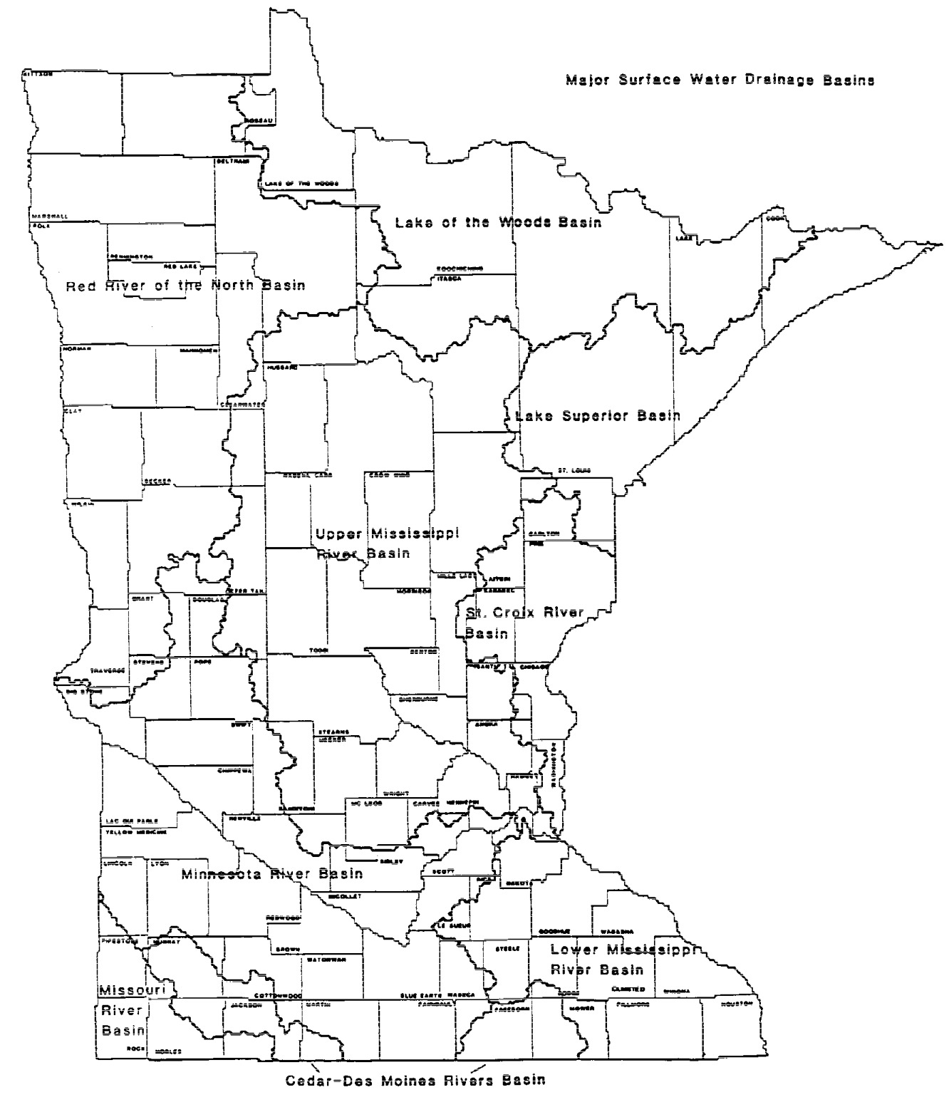
History:
18 SR 2195
Published Electronically:
April 1, 2008
7050.0467
[Repealed, 39 SR 154]
Published Electronically:
August 14, 2014
7050.0468 MAP: MINNESOTA ECOREGIONS.
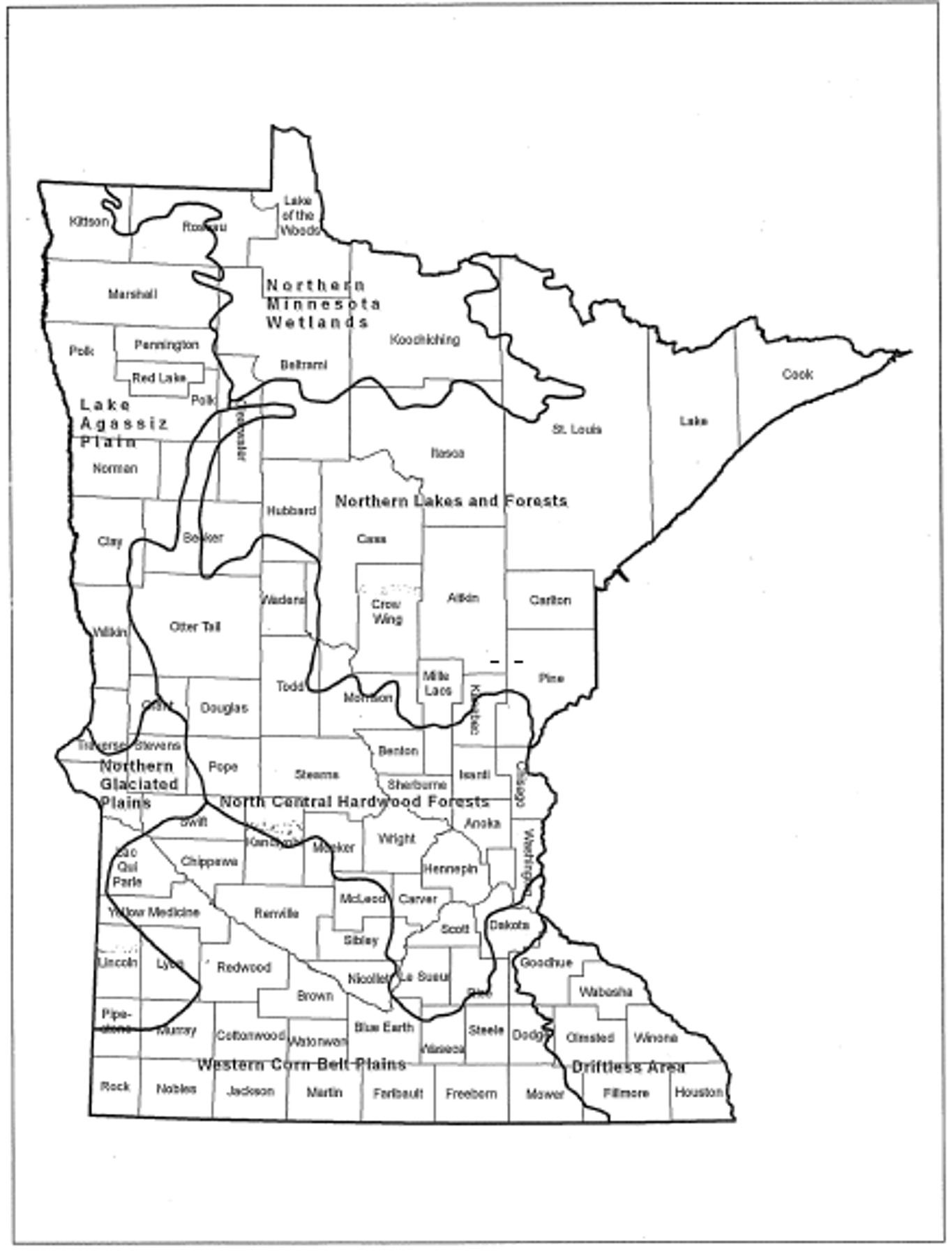
Statutory Authority:
MS s 115.03
History:
39 SR 154
Published Electronically:
August 14, 2014
7050.0470 CLASSIFICATIONS FOR SURFACE WATERS IN MAJOR DRAINAGE BASINS.
Subpart 1.
Lake Superior Basin.
The water use classifications for the listed waters in the Lake Superior Basin are as identified in items A to D. See parts 7050.0425 and 7050.0430 for the classifications of waters not listed.
A.
Streams:
(3)
Amity Creek, (T.50, R.13, S.5, 6; T.50, R.14, S.1; T.51, R.13, S.31, 32; T.51, R.14, S.26, 27, 28, 35, 36): 1B, 2A, 3B;
(4)
Amity Creek, East Branch (T.51, R.13, S.30, 31; T.51, R.14, S.13, 14, 15, 22, 24, 25, 36): 1B, 2A, 3B;
(6)
Anderson Creek, St. Louis County, (T.49, R.15, S.16, 17, 18; T.49, R.16, S.12, 13): 1B, 2A, 3B;
(8)
Assinika Creek, (T.63, R.1E, S.1; T.63, R.2E, S.7, 8, 16, 17, 21; T.64, R.1E, S.36; T.64, R.2E, S.31): 1B, 2A, 3B;
(10)
Baptism River, East Branch, (T.57, R.6, S.6; T.57, R.7, S.1, 2, 3, 9, 10, 11, 12, 16, 17, 20; T.58, R.6, S.30, 31; T.58, R.7, S.13, 17, 19, 20, 21, 22, 23, 24, 25, 26, 29, 30, 36; T.58, R.8, S.22, 23, 24, 25, 26): 1B, 2A, 3B;
(11)
Baptism River, Main Branch, (T.56, R.7, S.3, 4, 5, 9, 10, 14, 15; T.57, R.7, S.20, 27, 28, 29, 33, 34): 1B, 2A, 3B;
(12)
Baptism River, West Branch, (T.57, R.7, S.7, 17, 18, 20; T.57, R.8, S.1, 2, 12; T.58, R.8, S.2, 3, 4, 9, 10, 11, 15, 16, 20, 21, 22, 28, 33, 34, 35, 36; T.59, R.8, S. 34, 35): 1B, 2A, 3B;
(13)
Barber Creek (East Swan River) (Chisholm Creek) Chisholm, (T.58, R.20, S.21, 22, 26, 27, 34, 35): 7;
(14)
Barker Creek, (T. 60, R.3W, S.5, 6, 7, 8; T.60, R.4W, S.3, 9, 10, 11, 12; T.61, R.4W, S.34, 35): 1B, 2A, 3B;
(16)
Bear Trap Creek (Beartrap Creek), (T.51, R.16, S.30; T.51, R.17, S.16, 21, 22, 23, 25, 26, 27, 28): 1B, 2A, 3B;
(17)
Beaver Dam Creek (Beaverdam Creek), (T.63, R.3E, S.2, 3, 4, 5; T.64, R.3E, S.32, 33, 34, 35): 1B, 2A, 3B;
(18)
Beaver River (includes Kit Creek), (T.55, R.8, S.2, 3, 5, 6, 7, 8, 9, 10, 11, 12, 16, 17; T.55, R.9, S.1, 2; T.56, R.8, S.31; T.56, R.9, S.4, 5, 6, 8, 9, 16, 18, 19, 20, 21, 22, 23, 25, 26, 27, 28, 32, 33, 34, 35, 36; T.57, R.9, S.28, 32, 33): 1B, 2A, 3B;
(19)
Beaver River, East Branch (includes Hen Creek), (T.55, R.8, S.2; T.56, R.8, S.4, 5, 6, 8, 9, 15, 16, 21, 22, 25, 26, 27, 35, 36; T.57, R.8, S.7, 18, 19, 30, 31, 32; T.57, R.9, S.2, 3, 11, 12, 13, 14, 15, 23, 24, 25, 26, 36): 1B, 2A, 3B;
(20)
Beaver River, West Branch, (T.55, R.8, S.7, 17, 18; T.55, R.9, S.2, 3, 4, 10, 11, 12, 13, 14): 1B, 2A, 3B;
(21)
Berry Creek (Breda), (T.55, R.12, S.6, 7; T.55, R.13, S.12, 13; T.56, R.11, S.6; T.56, R.12, S.1, 11, 12, 14, 15, 16, 21, 28, 29, 31, 32; T.57, R.11, S.10, 15, 16, 21, 28, 29, 31, 32): 1B, 2A, 3B;
(22)
Blackhoof River, (T. 47, R.16, S.29, 30; T.47, R.17, S.6, 7, 9, 10, 14, 15, 16, 17, 18, 19, 20, 22, 25, 26, 27, 28; T.48, R.17, S.30, 31): 1B, 2A, 3B;
(24)
Blind Temperance Creek, (T.60, R.4W, S.19, 29, 30, 32; T.60, R.5W, S.24, 25, 36): 1B, 2A, 3B;
(28)
Brule River, (T.62, R.2E, S.1, 2; T.62, R.3E, S.4, 5, 6, 9, 10, 15, 16, 22, 27, 34; T.63, R.2E, S.21, 22, 23, 25, 26, 27, 28, 33, 35, 36; T.63, R.3E, S.30, 31, 32): 1B, 2A, 3B;
(29)
Brule River (excluding trout waters and waters within Boundary Waters Canoe Area Wilderness), (T.63, 64, R.1W, 1E, 2E): 1B, 2Bd, 3C;
(39)
Caribou River, (T.58, R.6, S.1, 2, 11, 13, 14, 15, 22, 23, 24, 25, 26, 36; T.59, R.6, S.23, 24, 25, 26, 35, 36): 1B, 2A, 3B;
(41)
Carlson Creek (Stony Brook), (T.62, R.4E, S.3, 4, 9, 10; T.63, R.4E, S.31, 32, 33, 34): 1B, 2A, 3B;
(42)
Cascade River, (T.60, R.2W, S.1; T.61, R.1W, S.19, 20, 21, 30, 31; T.61, R.2W, S.1, 12, 13, 14, 24, 25, 26, 35, 36; T.62, R.2W, S.10, 11, 14, 15, 16, 22, 23, 24, 25, 36): 1B, 2A, 3B;
(44)
Cascade River, North Branch (those waters outside the Boundary Waters Canoe Area Wilderness), (T.62, R.2W, S.10): 1B, 2A, 3B;
(47)
Cedar Creek, Cook County, (T.59, R.5W, S.2; T.60, R.5W, S.14, 22, 23, 25, 26, 35, 36): 1B, 2A, 3B;
(49)
Chellberg Creek (Chalberg Creek), (T.51, R.16, S.7; T.51, R.17, S.1, 2, 3, 10, 12): 1B, 2A, 3B;
(52)
Chicken Creek, (T.52, R.16, S.5, 7, 8, 18, 19; T.52, R.17, S.13, 24, 25; T.53, R.16, S.32): 1B, 2A, 3B;
(54)
Clear Creek, Carlton County, (T.47, R.15, S.7; T.47, R.16, S.1, 2, 3, 4, 12; T.48, R.16, S.33): 1B, 2A, 3B;
(57)
Colville Creek, East, (T.61, R.3E, S.5; T.62, R.2E, S.25; T.62, R.3E, S.30, 31, 32): 1B, 2A, 3B;
(60)
Cross River, (T.58, R.4W, S.6; T.58, R.5W, S.1; T.59, R.4W, S.31; T.59, R.5W, S.4, 5, 8, 9, 15, 16, 21, 22, 23, 25, 26, 35, 36; T.60, R.5W, S.30, 31, 32; T.60, R.6, S.13, 24, 25, 36): 1B, 2A, 3B;
(62)
Crown Creek, (T.57, R.8, S.2, 3, 4, 5, 9, 10, 11; T.58, R.8, S.5, 6, 7, 18, 19, 20, 29, 30, 31, 32, 33; T.58, R.9, S.1, 12, 13, 14, 24, 36; T.59, R.8, S.32): 1B, 2A, 3B;
(65)
Dago Creek, (T.54, R.9, S.18, 19; T.54, R.10, S.2, 11, 12, 13; T.55, R.10, S.27, 34, 35): 1B, 2A, 3B;
(67)
Deer Yard Creek (Spruce Creek), (T.60, R.2W, S.4, 5, 6, 7, 8, 9, 10, 15, 16, 17; T.61, R.2W, S.32): 1B, 2A, 3B;
(68)
Devil Track River, (T.61, R.1E, S.2, 3, 10, 11, 12, 13; T.62, R.1E, S.26, 31, 32, 33, 34, 35): 1B, 2A, 3B;
(69)
Devil Track River, Little, (T.61, R.1E, S.4, 5, 6, 7, 8, 9, 10; T.61, R.1W, S.1, 2, 11, 12): 1B, 2A, 3B;
(74)
Elbow Creek, Cook County, (T.62, R.1E, S.3, 4, 9, 10, 15, 22, 27, 34; T.63, R.1E, S.33, 34): 1B, 2A, 3B;
(77)
Encampment River, (T.53, R.10, S.3, 10, 11; T.54, R.10, S.8, 16, 17, 21, 27, 28, 34): 1B, 2A, 3B;
(81)
Flute Reed River, (T.62, R.3E, S.1, 2, 3, 10, 11, 12, 13, 14, 15; T.62, R.4E, S.17, 18, 20; T.63, R.3E, S.26, 34, 35, 36): 1B, 2A, 3B;
(84)
French River, (T.51, R.12, S.7, 17, 18; T.51, R.13, S.1, 2, 3, 12; T.52, R.13, S.8, 9, 16, 17, 20, 21, 23, 26, 27, 28, 29, 34, 35): 1B, 2A, 3B;
(88)
Gooseberry River, (T.54, R.9, S.18, 19, 20, 21, 22, 27; T.54, R.10, S.4, 5, 6, 8, 9, 10, 11, 12, 13; T.55, R.10, S.4, 9, 16, 17, 20, 29, 30, 31, 32; T.56, R.10, S.33): 1B, 2A, 3B;
(89)
Gooseberry River, Little, (T.54, R,10, S.6; T.54, R.11, S.1; T.55, R.10, S.31; T.55, R.11, S.34, 35, 36): 1B, 2A, 3B;
(90)
Grand Portage Creek, (T.63, R.5E, S.1; T.63, R.6E, S.4, 5, 6; T.64,; R.6E, S.31, 32, 33): 1B, 2A, 3B;
(91)
Greenwood River, (T.63, R.2E, S.1, 2, 3, 10, 11, 12, 13, 14, 15, 22, 23, 24; T.63, R.3E, S.6; T.64, R.2E, S.34; T.64, R.3E, S.31): 1B, 2A, 3B;
(92)
Hay Creek, (T.49, R.16, S.3, 4, 9, 10, 15; T.50, R.16, S.20, 21, 28, 29, 32, 33): 1B, 2A, 3B;
(93)
Heartbreak Creek, (T.59, R.4W, S.18, 19; T.59, R.5W, S.2, 11, 12, 13; T.60, R.5W, S.27, 28, 33, 34, 35): 1B, 2A, 3B;
(94)
Hellwig Creek, (T.52, R.17, S.3, 10, 14, 15, 23, 26; T.53, R.16, S.16, 18, 19, 20, 30; T.53, R.17, S.13, 14, 23, 24, 25, 26, 34, 35): 1B, 2A, 3B;
(95)
Hockamin Creek, (T.57, R.7, S.17, 18, 19; T.57, R.8, S.13, 16, 20, 21, 22, 23, 24, 25, 26, 27, 28, 29, 32, 33): 1B, 2A, 3B;
(98)
Hornby Junction Creek (Whiteface River, South Branch), (T.55, R.13, S.5,6, 7; T.56, R.13, S.28, 32, 33): 1B, 2A, 3B;
(100)
Houghtaling Creek, (T.59, R.6, S.2, 3, 4, 5, 6; T.60, R.6, S.25, 32, 33, 35, 36): 1B, 2A, 3B;
(102)
Hunter Creek (Hunters Creek), (T.46, R.18, S.2, 11, 12, 13; T.47, R.18, S.34, 35): 1B, 2A, 3B;
(105)
Irish Creek, (T.63, R.3E, S.8, 9, 10, 13, 14, 15, 23, 24, 25, 26; T.63, R.4E, S.17, 18, 19): 1B, 2A, 3B;
(106)
Joe Martin Creek (Martin Branch), (T.50, R.18, S.3, 4, 5, 7, 8; T.50, R.19, S.12): 1B, 2A, 3B;
(110)
Junco Creek, (T.62, R.1W, S.1, 2, 9, 10, 11, 12, 13, 14, 15, 16, 21, 28; T.62, R.1E, S.6, 7; T.63, R.1E, S.20, 29, 30, 31; T.63, R.1W, S.24, 25, 35): 1B, 2A, 3B;
(111)
Kadunce Creek (Kadunce River), (T.61, R.2E, S.2; T.62, R.2E, S.9, 10, 12, 13, 14, 15, 16, 22, 23, 24, 26, 35): 1B, 2A, 3B;
(112)
Keene Creek, (T.49, R.14, S.18; T.49, R.15, S.1, 12, 13; T.50, R.15, S.24, 25, 36): 1B, 2A, 3B;
(114)
Kimball Creek, (T.61, R.2E, S.3, 4, 10; T.62, R.2E, S.7, 16, 17, 18, 19, 20, 21, 28, 29, 33, 34): 1B, 2A, 3B;
(117)
Knife River, (T.52, R.11, S.4, 5, 8, 9, 17, 18, 19, 31; T.53, R.11, S.4, 5, 7, 8, 17, 18, 20, 29, 32, 33; T.54, R.11, S.20, 29, 32; T.52, R.12, S.24, 25, 36): 1B, 2A, 3B;
(120)
Knife River, Little, West Branch, (T.52, R.11, S.6; T.53, R.11, S.31; T.53, R.12, S.13, 14, 23, 24, 25, 26, 36): 1B, 2A, 3B;
(121)
Knife River, West Branch, (T.52, R.11, S.5, 6, 8; T.52, R.12, S.1; T.53, R.12, S.2, 3, 10, 15, 16, 22, 23, 27, 28, 34, 35, 36; T.54, R.12, S.35, 36): 1B, 2A, 3B;
(125)
Lester River, (T.50, R.13, S.4, 5, 8; T.51, R.13, S.5, 6, 7, 8, 16, 17, 18, 19, 20, 21, 28, 32, 33; T.51, R.14, S.1, 2, 10, 11, 12, 13, 15, 16, 24; T.52, R.13, S.31, 32; T.52, R.14, S.21, 22, 23, 27, 28, 34, 35): 1B, 2A, 3B;
(126)
Lindstrom Creek, (T.56, R.7, S.4; T.57, R.7, S.19, 30, 31, 32, 33; T.57, R.8, S.25): 1B, 2A, 3B;
(129)
Manitou River (Moose Creek), (T.57, R.6, S.3, 4, 10, 11; T.58, R.6, S.4, 5, 6, 7, 8, 16, 17, 18, 20, 21, 28, 29, 32, 33, 34): 1B, 2A, 3B;
(131)
Manitou River, North Branch (Balsam Creek), (T.58, R.6, S.6; T.58, R.7, S.1, 2; T.59, R.6, S.31; T.59, R.7, S.15, 16, 18, 19, 20, 21, 22, 25, 26, 27, 28, 33, 34, 35, 36; T.59, R.8, S.1, 2, 12, 13, 24, 25, 26): 1B, 2A, 3B;
(132)
Manitou River, South Branch (Junction Creek), (T.58, R.6, S.6; T.58, R.7, S.1, 4, 5, 6, 7, 8, 9, 10, 11, 12, 16, 17, 18; T.58, R.8, S.1; T.59, R.7, S.29, 30, 31, 32, 33): 1B, 2A, 3B;
(138)
Midway River (Rock Run), (T.49, R.15, S.5, 6; T.49, R.16, S.1, 12, 13, 14, 15, 21, 22; T.50, R.15, S.7, 8, 14, 15, 16, 17, 20, 21, 22, 23, 28, 29, 32, 33): 1B, 2A, 3B;
(139)
Mile Post Forty-Three Creek (Fortythree Creek, East and West Branch), (T.56, R.8, S.2, 3, 10, 11, 13, 14, 15): 1B, 2A, 3B;
(140)
Miller Creek, (T.49, R.14, S.4; T.50, R.14, S.6, 18, 19, 29, 30, 32, 33; T.50, R.15, S.12, 13; T.51, R.14, S.31, 32): 1B, 2A, 3B;
(141)
Mink Creek, (T.54, R.9, S.4, 5, 9; T.55, R.9, S.30, 31, 32; T.55, R.10, S.25, 26, 36): 1B, 2A, 3B;
(142)
Mission Creek, (T.48, R.15, S.5, 6; T.49, R.15, S.31; T.49, R.16, S.25, 26, 36): 1B, 2A, 3B;
(143)
Mississippi Creek, (T.61, R.2W, S.1, 2, 3; T.61, R.3W, S.1; T.62, R.2W, S.31, 32, 33, 34, 35, 36; T.62, R.3W, S.24, 25, 35, 36): 1B, 2A, 3B;
(145)
Mistletoe Creek, (T.60, R.3W, S.3, 4; T.61, R.2W, S.7, 18; T.61, R.3W, S.11, 13, 14, 15, 23, 24, 25, 26, 34, 35): 1B, 2A, 3B;
(149)
Mud Creek, Carlton County, (T.47, R.15, S.18; T.47, R.16, S.5, 6, 8, 9, 10, 11, 13, 14, 15, 16): 1B, 2A, 3B;
(154)
Murphy Creek (Maki Creek), (T.56, R.11, S.4, 5, 8, 17, 18, 19; T.57, R.10, S.4, 7, 8, 9, 18; T.57, R.11, S.13, 21, 22, 23, 24, 26, 27, 28, 33, 34): 1B, 2A, 3B;
(157)
Nemadji River, North Fork (Nemadji River), (T.46, R.17, S.1, 2, 3, 8, 9, 10, 17, 18, 19, 31, 32, 33; T.46, R.18, S.24, 25, 36; T.47, R.15, S.19, 30; T.47, R.16, S.23, 24, 25, 26, 27, 28, 29, 31, 32; T.47, R.17, S.35, 36): 1B, 2A, 3B;
(158)
Nemadji River, South Fork, (T.46, R.16, S.4, 5, 6, 7; T.46, R.17, S.1, 11, 12; T.47, R.15, S.30; T.47, R.16, S.25, 33, 34, 35, 36): 1B, 2A, 3B;
(159)
Nestor Creek (Nester Creek), (T.61, R.1W, S.4, 5, 6; T.61, R.2W, S.1; T.62, R.1W, S.31, 32, 33): 1B, 2A, 3B;
(160)
Net River, (T.45, R.16, S.6; T.45, R.17, S.1; T.46, R.16, S.3, 4, 8, 9, 17, 20, 21, 29, 31, 32, 33; T.47, R.16, S.34;): 1B, 2A, 3B;
(162)
Nicadoo Creek (Nicado Creek), (T.56, R.7, S.7; T.56, R.8, S.1, 12; T.57, R.8, S.27, 35, 36): 1B, 2A, 3B;
(163)
Nine Mile Creek (Ninemile Creek), (T.58, R.6, S.3, 4, 9, 16, 17; T.59, R.6, S.27, 28, 33, 34): 1B, 2A, 3B;
(164)
Oliver Creek (Silver), (T.57, R.7, S.5, 6; T.57, R.8, S.1; T.58, R.7, S.31, 32): 1B, 2A, 3B;
(165)
Onion Creek (Onion River and West Branch Onion River), (T.59, R.4W, S.1, 2, 3, 4, 12; T.60, R.4W, S.24, 25, 26, 35, 36): 1B, 2A, 3B;
(166)
Otter Creek, Big (Otter Creek), (T.48, R.16, S.7; T.48, R.17, S.3, 10, 11, 12; T.49, R.17, S.19, 20, 26, 27, 28, 29, 30, 32, 33, 34, 35; T.49, R.18, S.25, 26): 1B, 2A, 3B;
(167)
Otter Creek, Little, (T.48, R.17, S.7, 10, 15, 16, 17, 18; T.48, R.18, S.11, 12, 13, 14): 1B, 2A, 3B;
(176)
Pine River (White Pine River), (T.50, R.16, S.4, 8, 9, 15, 16, 17, 18, 19, 20, 21, 29, 30, 32; T.50, R.17, S.23, 24, 26): 1B, 2A, 3B;
(177)
Plouff Creek, (T.61, R.4W, S.17, 18; T.61, R.5W, S.2, 3, 11, 13, 14, 15, 23; T.62, R.5W, S.26, 34, 35): 1B, 2A, 3B;
(179)
Poplar River (Missouri Creek), (T.60, R.3W, S.3, 4, 5, 6, 9, 10, 15, 16, 17, 19, 20, 21, 28, 33; T.61, R.3W, S.30, 31; T.61, R.4W, S.10, 13, 14, 15, 22, 23, 25, 26, 36): 1B, 2A, 3B;
(180)
Portage Brook, (T.64, R.3E, S.24, 25, 26, 27, 28, 29, 32, 33, 34; T.64, R.4E, S.19, 20): 1B, 2A, 3B;
(184)
Reservation River, (T.62, R.5E, S.6; T.63, R.4E, S.23, 25, 26, 36; T.63, R.5E, S.16, 17, 18, 19, 20, 21, 29, 30, 31): 1B, 2A, 3B;
(187)
Rocky Run Creek, (T.49, R.15, S.6; T.50, R.15, S.30, 31; T.50, R.16, S.11, 12, 13, 24, 25): 1B, 2A, 3B;
(202)
Silver Creek, Lake County, (T.53, R.10, S.6, 7, 16, 17, 18, 21; T.53, R.11, S.1; T.54, R.10, S.18, 19, 30; T.54, R.11, S.11, 12, 13, 25, 36): 1B, 2A, 3B;
(203)
Silver Creek, Big (Silver Creek), Carlton County, (T.46, R.17, S.14, 23, 24, 25, 36): 1B, 2A, 3B;
(206)
Skunk Creek, Lake County, (T.54, R.9, S.4, 9, 16, 17, 20; T.55, R.9, S.19, 29, 30, 32, 33; T.55, R.10, S.13, 14, 24): 1B, 2A, 3B;
(207)
Skunk Creek, Carlton County, (T.46, R.17, S.4, 5, 6; T.47, R.17, S.31, 33, 34, 35, 36; T.47, R.18, S.36): 1B, 2A, 3B;
(208)
Spider Creek, (T.52, R.18, S.19, 20, 21, 22, 27, 28, 29, 30; T.52, R.19, S.9, 10, 13, 14, 15, 24): 1B, 2A, 3B;
(209)
Split Rock River, (T.54, R.8, S.6, 7; T.54, R.9, S.1, 2, 12; T.55, R.9, S.26, 28, 34, 35, 36): 1B, 2A, 3B;
(210)
Split Rock River, East Branch, (T.55, R.9, S.4, 5, 6, 9, 10, 14, 15, 22, 23, 24, 25, 26; T.56, R.9, S.30, 31, 32; T.56, R.10, S.1, 11, 12, 13, 14, 24, 25): 1B, 2A, 3B;
(211)
Split Rock River, West Branch, (T.55, R.9, S.6, 7, 8, 16, 17, 21, 22, 26, 27, 28; T.55, R.10, S.1; T.56, R.10, S.22, 26, 27, 33, 34, 35, 36): 1B, 2A, 3B;
(214)
Stanley Creek, (T.52, R.11, S.18, 19; T.52, R.12, S.4, 5, 8, 9, 10, 11, 12, 13): 1B, 2A, 3B;
(215)
State Line Creek, (T.46, R.15, S.6, 7, 18, 19, 30, 31; T.46, R.16, S.12, 13, 24, 25, 36; T.47, R.15, S.30, 31): 1B, 2A, 3B;
(217)
Stewart River, (T.53, R.10, S.18, 19, 20, 29; T.53, R.11, S.2, 3, 10, 11, 13, 14, 15; T.54, R.11, S.3, 4, 10, 15, 22, 26, 27, 34, 35): 1B, 2A, 3B;
(219)
Stewart River, Little, (T.53, R.10, S.19, 20, 29; T.53, R.11, S.9, 15, 16, 22, 23, 24): 1B, 2A, 3B;
(222)
Stoney Creek (Stony Creek or Rock Creek), Lake County, (T.55, R.9, S.30; T.55, R.10, S.20, 23, 24, 25, 27): 1B, 2A, 3B;
(224)
Stony Creek, Little, Cook County, (T.63, R.2E, S.4, 5, 9; T.64, R.2E, S.31, 32, 33): 1B, 2A, 3B;
(227)
Stump River (Lower Stump River), (T.64 R.4E, S.18; T.64, R.3E, S.8, 9, 13, 14, 15, 16, 17, 21, 22, 23, 24): 1B, 2A, 3B;
(228)
Sucker River (Big Sucker Creek), (T.51, R.12, S.3, 4, 10; T.52, R.12, S.18, 19, 29, 30, 31, 32, 33; T.52, R.13, S.1, 12, 13, 24, 25; T.53, R.12, S.19, 20, 30, 31; T.53, R.13, S.24, 25, 36): 1B, 2A, 3B;
(231)
Sullivan Creek, (T.56, R.11, S.1, 2, 10, 11, 15; T.57, R.10, S.19, 30; T.57, R.11, S.24, 25, 36): 1B, 2A, 3B;
(233)
Swamp River, (T.63, R.3E, S.25, 26, 36; T.63, R.4E, S.20, 29, 30; T.64, R.4E, S.21, 27, 28): 1B, 2A, 3B;
(237)
Swan River, East (Barber Creek), (T.55, R.19, S.18, 19, 30, 31; T.55, R.20, S.1, 2, 12, 13; T.56, R.20, S.2, 3, 11, 14, 23, 26, 27, 35; T.57, R.20, S.28, 33, 34): 1B, 2A, 3B;
(241)
Talmadge Creek (Talmadge River), (T.51, R.12, S.19; T.51, R.13, S.9, 10, 13, 14, 15, 24): 1B, 2A, 3B;
(242)
Temperance River, (T.59, R.4W, S.5, 6, 7, 8, 18, 19, 30, 31, 32; T.60, R.4W, S.5, 6, 7, 8, 17, 20, 28, 29, 32, 33; T.61, R.4W, S.4, 8, 9, 16, 17, 19, 20, 30, 31): 1B, 2A, 3B;
(244)
Thirty-nine Creek, Big, (T.56, R.8, S.19, 30, 31; T.56, R.9, S.1, 2, 3, 11, 12, 13, 14, 15, 22, 23, 24, 25; T.57, R.9, S.22, 26, 27, 35, 36): 1B, 2A, 3B;
(245)
Thirty-nine Creek, Little, (T.56, R.8, S.6, 7, 8, 17, 18, 19, 20, 29, 30; T.56, R.9, S.1, 12): 1B, 2A, 3B;
(249)
Tischer Creek (Congdon Creek/Hartley), (T.50, R.14, S.2, 3, 4, 10, 11, 13, 14; T.51, R.14, S.29, 33, 34): 1B, 2A, 3B;
(251)
Tower Creek, St. Louis County, (T.55, R.14, S.8, 9, 17, 18, 19; T.55, R.15, S.24, 25, 26): 1B, 2A, 3B;
(256)
Two Island River, (T.58, R.5W, S.2, 3, 4, 11; T.59, R.5W, S.7, 8, 17, 18, 20, 21, 27, 28, 29, 31, 32, 33, 34; T.59, R.6, S.11, 12): 1B, 2A, 3B;
(266)
Us-kab-wan-ka (Rush), (T.52, R.16, S.2, 11, 14, 23; T.53, R.15, S.5, 6; T.53, R.16, S.1, 11, 12, 14, 15, 22, 23, 27, 34, 35; T.54, R.15, S.23, 24, 26, 27, 32, 33, 34): 1B, 2A, 3B;
(271)
Wyman Creek, (T.58, R.14, S.3, 4; T.59, R.14, S.11, 13, 14, 23, 24, 26, 27, 34, 35): 1B, 2A, 3B; and
B.
Lakes:
(54)
Fraser Mine Pit Lake, (T.58, R.20, S.23): 1C, 2Bd, 3C, until the city of Chisholm no longer uses Fraser Mine Pit Lake as a water supply source for its public water system, and then the classification is identified in part 7050.0430;
(69)
*Lily Lakes (Vaseux Lake and Fan Lake), 16-0083-00 and 16-0084-00, [11/5/84P] (T.65, R.2E): 1B, 2Bd, 3A;
(92)
Northern Light Lake, 16-0089-00, [WR] (T.63, R.2E, S.29, 30, 31, 32, 33; T.63, R.1E, S.25): 2B, 3B;
(126)
Stone Lake, 69-0686-00, [WR] (T.55, R.17, S.6; T.55, R.18, S.1; T.56, R.17, S.31; T.56, R.18, S.36): 2B, 3B;
(129)
*Superior, Lake, excluding the portions identified in subitem (130) 16-0001-00, [11/5/84R] (T.49, 50, 51, 52, 53, 54, 55, 56, 57, 58, 59, 60, 61, 62, 63, 64, R.14W-7E): 1B, 2A, 3A;
(130)
*Superior, Lake, 16-0001-00, [3/9/98P] (those portions of Lake Superior north of latitude 47 degrees, 57 minutes, 13 seconds, east of Hat Point, south of the Minnesota-Ontario boundary, and west of the Minnesota-Michigan boundary): 1B, 2A, 3A;
(145)
*Unnamed Lake, 16-0237-00, [11/5/84P] (T.63, R.1, S.19, 30; T.63, R.2, S.24, 25): 1B, 2Bd, 3B;
D.
Scientific and Natural Areas: *Black Lake Bog [3/7/88P] Waters within the Black Lake Bog Scientific and Natural Area, Pine County, (T.45, R.15, S.18, 19, 30; T.45, R.16, S.13, 24, 25): 2B, 3B, except wetlands which are 2D.
Subp. 2.
Lake of the Woods Basin.
The water use classifications for the listed waters in Lake of the Woods Basin are as identified in items A to D. See parts 7050.0425 and 7050.0430 for the classifications of waters not listed.
A.
Streams:
(2)
Arrowhead Creek (Trapper Creek), (T.60, R.8, S.3, 10, 11, 13, 14, 15, 22, 23, 26, 27, 28, 34; T.61, R.8, S.14, 15, 21, 22, 27, 28, 34): 1B, 2A, 3B;
(3)
Ash River (Camp Ninety Creek), (T.66, R.20, S.4, 5, 9; T.67, R.20, S.5, 6, 8, 16, 17, 18, 19, 20, 29, 30, 31, 32; T.67, R.21, S.36; T.68, R.20, S.13, 14, 20, 21, 22, 23, 24, 28, 29, 31, 33; T.68, R.19, S.17, 18; T.68, R.21, S.36): 1B, 2A, 3B;
(6)
Blackduck River (Black Duck River), (T.66, R.19, S.5, 6, 7, 8, 17; T.66, R.20, S.1; T.67, R.19, S.29, 31, 32; T.67, R.20, S.2, 3, 4, 10, 14, 15, 23, 24, 25, 26, 36; T.68, R.20, S.26, 27, 28, 33, 34): 1B, 2A, 3B;
(11)
Dinner Creek, (T.153, R.26, S.4, 9, 10, 12, 13, 14, 15, 23, 24; T.154, R.26, S.7, 18, 19, 29, 30, 32, 33; T.154, R.27, S.1, 12; T.155, R.26, S.30, 31; T.155, R.27, S.25, 35, 36): 1B, 2A, 3B;
(12)
Dumbbell River, (T.60, R.7, S.3, 4, 5, 7, 8, 9, 10, 16, 18, 19, 20, 28, 29, 31, 32; T.61, R.7, S.34): 1B, 2A, 3B;
(13)
Fawn Creek, (T.66, R.20, S.1, 2, 3, 4, 12; T.67, R.20, S.15, 22, 23, 26, 34, 35): 1B, 2A, 3B;
(24)
Isabella River, Little, (T.59, R.8, S.3, 4, 5, 6, 9, 10, 15, 16, 22; T.60, R.8, S.31, 32; T.60, R.9, S.5, 6, 8, 9, 10, 15, 16, 22, 25, 26, 27, 36; T.61, R.9, S.9, 16, 17, 20, 21, 29, 32): 1B, 2A, 3B;
(27)
Jack Pine Creek, (T.60, R.8, S.5, 6, 7, 8, 18; T.61, R.8, S.19, 20, 29, 30, 31, 32): 1B, 2A, 3B;
(29)
Kawishiwi River, outside Boundary Waters Canoe Area Wilderness, (Source to Fall Lake): 1B, 2Bd, 3C;
(30)
Kinmount Creek, (T.67, R.20, S.19; T.67, R.21, S.13, 14, 15, 20, 21, 22, 23, 24): 1B, 2A, 3B;
(32)
Lost River, (T.65, R.19, S.6; T.65, R.20, S.1, 2, 3, 4, 5, 6, 7, 8, 12; T.65, R.21, S.1; T.66, R.20, S.20, 25, 27, 29, 31, 32, 33, 34, 35, 36): 1B, 2A, 3B;
(35)
Mitawan Creek, (T.60, R.9, S.1, 12; T.61, R.8, S.18, 19, 31; T.61, R.9, S.12, 13, 24, 25, 36): 1B, 2A, 3B;
(36)
*Mitawan Creek, [11/5/84P] (T.61, R.8, S.5, 6, 7; T.61, R.9, S.1, 2, 12; T.62, R.9, S.35): 1B, 2A, 3B;
(39)
Nine Mile Creek (Ninemile Creek), (T.66, R.19, S.4; T.67, R.19, S.7, 8, 18, 19, 20, 21, 27, 28, 29, 33; T.67, R.20, S.12, 13, 14, 23): 1B, 2A, 3B;
(48)
Sand Creek, (T.60, R.21, S.3, 4, 5, 10, 11, 14; T.61, R.20, S.19; T.61, R.21, S.3, 10, 11, 14, 15, 23, 24, 25, 26, 27, 33, 34, 35; T.62, R.21, S.34): 1B, 2A, 3B;
(49)
Scott Creek, (T.59, R.7, S.4; T.60, R.7, S.9, 10, 15, 16, 21, 22, 27, 33, 34, 35): 1B, 2A, 3B;
(53)
Snake Creek, (T.60, R.10, S.1; T.61, R.9, S.19, 30, 31; T.61, R.10, S.24, 25, 36): 1B, 2A, 3B;
(54)
Snake River, (T.60, R.10, S.3; T.61, R.9, S.18, 19; T.61, R.10, S.23, 24, 26, 27, 34): 1B, 2A, 3B;
(57)
Stoney Brook (Stony Brook), (T.60, R.22, S.3, 4; T.61, R.22, S.13, 24, 25, 35, 36; T.61, R.21, S.7, 18): 1B, 2A, 3B;
(61)
Two Rivers, East, (T.61, R.14, S.7, 8; T.61, R.15, S.1, 2, 3, 4, 12; T.62, R.14, S.29, 30, 31, 32; T.62, R.15, S.32, 33, 34, 35, 36): 1B, 2A, 3B;
(64)
Valley River, (T.62, R.23, S.1, 2, 3, 4, 10, 11, 12, 13, 14, 24; T.63, R.22, S.6, 7, 8, 9, 16, 17, 18, 19, 20, 21, 28, 29, 30; T.63, R.23, S.24, 25, 26, 35): 1B, 2A, 3B;
B.
Lakes:
(29)
*Crab Lake (includes West Crab Lake, 69-0297-00), 69-0220-00, [11/5/84P] (T.63, R.13, 14): 1B, 2A, 3B;
(95)
Lake of the Woods, 39-0002-00, (T.161, 162, 163, 164, 165, 166, 167, 168, R.30, 31, 32, 33, 34, 35, 36): 1B, 2Bd, 3A;
(171)
*Trygg (Twigg) Lake, 69-0389-00, [11/5/84P] (T.68, R.14W, S.31; T.68, R.15W, S.36): 1B, 2A, 3B;
D.
Scientific and Natural Areas: *Purvis Lake-Ober, [11/5/84P] Waters within the Purvis Lake-Ober Foundation Scientific and Natural Area, Saint Louis County, (T.62, R.13): 2B, 3B, except wetlands which are 2D.
Subp. 3.
Red River of the North Basin.
The water use classifications for the listed waters in the Red River of the North Basin are as identified in items A to D. See parts 7050.0425 and 7050.0430 for the classifications of waters not listed.
A.
Streams:
(3)
Badger Creek (Lower Badger Creek or County Ditch No. 11), (T.149, 150, 151, R.42, 43, 44): 2C;
(4)
Barnums Creek (Burnham Creek or County Ditch No. 72), (T.148, 149, 150, R.44, 45, 46, 47, 48): 2C;
(10)
Clearwater River, (T.148, R.35, S.5, 6, 8, 17, 20, 29, 31, 32; T.149, R.35, S.20, 29, 31, 32): 1B, 2A, 3B;
(18)
Elbow Lake Creek (Solid Bottom Creek), (T.142, R.38, S.6; T.143, R.38, S.31, 32): 1B, 2A, 3B;
(19)
Felton Creek, (T.141, R.44, S.7, 8, 17; T.141, R.45, S.7, 8, 12, 13, 14, 15, 16, 17, 18, 22; T.141, R.46, S.12, 13, 14): 1B, 2A, 3B;
(30)
Judicial Ditch No. 18, Goodridge, (T.154, R.40, S.18, 19, 27, 28, 29, 30; T.154, R.41, S.13, 14, 15, 16, 17, 18; T.154, R.42, S.7, 8, 13, 14, 15, 16; T.154, R.43, S.9, 10, 11, 12, 16): 7;
(53)
Schermerhorn Creek (Shimmelhorn Creek), (T.144, R.39, S.6; T.145, R.39, S.31; T.145, R.40, S.25, 26, 36): 1B, 2A, 3B;
(61)
Tamarac River (Source to the dam in S.5, T.157, R.48 at Stephen), (T.157, 158, R.45, 46, 47, 48): 1C, 2Bd, 3C;
(62)
Toad River, (T.138, R.38, S.6, 7, 18, 19, 30; T.139, R.38, S.30, 31; T.139, R.39, S.25, 36; T.138, R.39, S.25, 36): 1B, 2A, 3B;
(64)
Twelve Mile Creek (County Ditch No. 1), Donnelly, (T.126, R.43, S.16, 17, 18, 19, 21, 22, 25, 26, 27; T.126, R.44, S.23, 24, 25, 26, 27, 28, 29, 30, 31, 32, 33; T.126, R.45, S.25, 26, 27, 28, 36): 7;
(66)
Twelve Mile Creek, West Branch (West Branch Twelvemile Creek), (T.125, 126, 127, 128, R.45, 46): 2C;
(80)
Unnamed Ditch, Warroad, (T.163, R.37, S.19, 20, 21, 22, 23; T.163, R.38, S.19, 20, 21, 22, 23, 24, 30; T.163, R.39, S.25, 31, 32, 33, 34, 35, 36): 7;
D.
Scientific and Natural Areas:
(1)
*Green Water Lake, [11/5/84P] Waters within the Green Water Lake Scientific and Natural Area, Becker County, (T.141, R.38, S.28, 33, 34): 2B, 3B, except wetlands which are 2D; and
(2)
*Pembina Trail Preserve, [3/7/88P] Waters within the Pembina Trail Preserve Scientific and Natural Area, Polk County, (T.148, R.45, S.1, 2; T.149, R.44, S.18, 19, 30, 31; T.149, R.45, S.13, 24, 25, 36): 2B, 3B, except wetlands which are 2D.
Subp. 4.
Upper Mississippi River Basin (headwaters to the confluence with the St. Croix River).
The water use classifications for the listed waters in the Upper Mississippi River Basin from the headwaters to the confluence with the St. Croix River are as identified in items A to D. See parts 7050.0425 and 7050.0430 for the classifications of waters not listed.
A.
Streams:
(23)
Branch No. 3, Lateral 2, East Bethel/Ham Lake, (T.33, R.23, S.29, 32, along the west side of Minnesota Highway 65): 7;
(25)
Bruce Creek, (T.53, R.22, S.6, 7; T.53, R.23, S.26; T.54, R.22, S.18, 19, 30, 31; T.54, R.23, S.25): 1B, 2A, 3B;
(27)
Buckman Creek, Buckman, Buckman Coop Cry., (T.39, R.30, S.4, 5, 6, 9; T.39, R.31, S.1, 2, 10, 11; T.40, R.30, S.31; T.40, R.31, S.36): 7;
(28)
Bungo Creek, (T.137, R.30, S.6; T.137, R.31, S.1, 11, 12, 14, 21, 22, 23; T.138, R.30, S.31): 1B, 2A, 3B;
(29)
Bungoshine Creek (Bungashing Creek), (T.145, R.32, S.28, 29, 30; T.145, R.33, S.25, 26, 34, 35): 1B, 2A, 3B;
(30)
Bunker Hill Brook (Bunker Hill Creek), (T.38, R.30, S.6; T.38, R.31, S.1, 2, 10, 11): 1B, 2A, 3B;
(42)
County Ditch No. 15 (Bear Creek), Bertha, (T.132, R.35, S.2; T.133, R.34, S.7; T.133, R.35, S.12, 13, 24, 25, 26, 35): 7;
(46)
County Ditch No. 28, East Bethel/Ham Lake, (T.32, R.23, S.4, 5, 6; T.33, R.23, S.29, 32 along the east side of Minnesota Highway 65): 7;
(47)
County Ditch No. 42, McGregor, (T.47, R.23, S.6; T.47, R.24, S.1; T.48, R.23, S.29, 31, 32): 7;
(48)
County Ditch No. 63, Near Hutchinson, West Lynn Coop Cry., (T.116, R.30, S.19, 20, 21, 28, 33): 7;
(52)
*Crow River, North Fork, [11/5/84R] (From the Lake Koronis outlet to the Meeker - Wright County line): 2B, 3C;
(64)
Farnham Creek, (T.135, R.32, S.5, 6, 7; T.136, R.32, S.2, 3, 9, 10, 16, 19, 20, 21, 29, 30, 31, 32): 1B, 2A, 3B;
(76)
Hasty Brook, (T.49, R.19, S.18; T.49, R.20, S.4, 5, 9, 10, 13, 14, 15, 23; T.50, R.20, S.28, 29, 32, 33): 1B, 2A, 3B;
(91)
Judicial Ditch No. 15, Buffalo Lake, Iowa Pork Industries, Hector, (T.115, R.31, S.15, 16, 20, 21, 29, 30; T.115, R.32, S.22, 25, 26, 27, 28, 32, 33): 7;
(92)
Kabekona River, (T.143, R.32, S.6, 7, 18, 19; T.143, R.33, S.2, 3, 4, 9, 11, 12, 24; T.144, R.33, S.29, 30, 32, 33; T.144, R.34, S.24, 25, 36): 1B, 2A, 3B;
(110)
Meyers Creek (Johnson Creek), (T.122, R.28, S.4; T.123, R.28, S.22, 27, 33, 34): 1B, 2A, 3B;
(115)
*Mississippi River, [11/5/84R] (From Lake Itasca to Fort Ripley, at the common boundary of Crow Wing and Morrison Counties): 2B, 3C;
(116)
*Mississippi River, [11/5/84R] (From Fort Ripley, at the common boundary of Crow Wing and Morrison Counties, to the southerly boundary of Morrison County): 1C, 2Bd, 3C;
(117)
Mississippi River, (From the southerly boundary of Morrison County to Stearns County State-Aid Highway 7 bridge in Saint Cloud in S.13, T.124, R.28): 1C, 2Bd, 3C;
(118)
*Mississippi River, [11/5/84R] (Stearns County State-Aid Highway 7 bridge in Saint Cloud in S.13, T.124, R.28 to the northwestern city limits of Anoka, river mile 873.5): 1C, 2Bd, 3C;
(119)
Mississippi River, (From the northwestern city limits of Anoka, river mile 873.5, to the Upper Lock and Dam at Saint Anthony Falls in Minneapolis): 1C, 2Bd, 3C;
(120)
Mississippi River, (Outlet of Metro Wastewater Treatment Works in Saint Paul, river mile 835.3, to river mile 830, Rock Island RR Bridge): 2C, 3C;
(121)
Morrison Brook, (T.52, R.26, S.4, 9, 10, 14, 15; T.53, R.26, S.7, 8, 18, 19, 29, 30, 32, 33): 1B, 2A, 3B;
(142)
Poplar Brook (Martin Creek), (T.135, R.32, S.5, 6; T.136, R.32, S.22, 27, 28, 32, 33): 1B, 2A, 3B;
(148)
Rock Creek, Little, (T.38, R.31, S.3, 4, 10, 15, 21, 22, 28; T.39, R.30, S.17, 18, 20, 21, 22; T.39, R.31, S.13, 14, 22, 23, 27, 33, 34): 1B, 2A, 3B;
(152)
Round Prairie Creek (Trout Creek), (T.127, R.33, S.4; T.128, R.33, S.20, 29, 32, 33): 1B, 2A, 3B;
(153)
*Rum River, [11/5/84P] (From the Ogechie Lake spillway to the northernmost confluence with Lake Onamia): 2B, 3B;
(154)
*Rum River, [11/5/84R] (From the State Highway 27 bridge in Onamia to Madison and Rice Streets in Anoka): 2B, 3C;
(155)
Sand Creek, Crow Wing County, (T.45, R.30, S.2, 3, 11, 13, 14; T.46, R.30, S.34): 1B, 2A, 3B;
(164)
Skunk River (Co. Dt. No. 37) (Co. Dt. No. 29), Brooten, (T.123, R.35, S.4, 5, 9; T.123, R.35, S.9, 10, 11, 12; T.123, R.34, S.3, 4, 5, 6, 7, 8): 7;
(166)
Smith Creek, (T.53, R.26, S.1, 9, 10, 11, 12, 13, 14, 15; T.54, R.26, S.35, 36): 1B, 2A, 3B;
(169)
Snake River, (T.33, R.28, S.1; T.34, R.28, S.2, 11, 14, 23, 26, 35, 36; T.35, R.28, S.20, 28, 29, 33, 34, 35): 1B, 2A, 3B;
(177)
Spruce Creek, (T.130, R.36, S.3, 4, 9, 10; T.131, R.36, S.28, 29, 31, 32, 33, 34): 1B, 2A, 3B;
(182)
Stoney Brook (Stony Brook), Cass County, (T.135, R.29, S.5, 8, 9; T.136, R.29, S.30, 31, 32; T.136, R.30, S.20, 21, 22, 25, 26, 27, 29, 30; T.136, R.31, S.24, 25, 26): 1B, 2A, 3B;
(183)
Stony Brook (Stoney Brook), Foley, (T.36, R.29, S.2, 9, 10, 11, 16; T.37, R.29, S.35, 36): 7;
(186)
Straight Creek, Upper, (Straight River), (T.140, R.36, S.6; T.141, R.36, S.30, 31; T.141, R.37, S.24, 25): 1B, 2A, 3B;
(188)
Straight River, (T.139, R.34, S.7; T.139, R.35, S.4, 5, 6, 9, 10, 11, 12; T.139, R.36, S.1; T.140, R.36, S.28, 29, 33, 34, 35, 36): 1B, 2A, 3B;
(205)
Union Creek, (T.134, R.35, S.4, 5, 7, 8, 18, 19, 30, 31; T.135, R.35, S.27, 28, 33, 34): 1B, 2A, 3B;
(217)
Unnamed Ditch, Ramey, Ramey Farmers Coop Cry., (T.38, R.28, S.4, 5; T.39, R.28, S.29, 30, 32; T.39, R.29, S.25, 26, 27, 28): 7;
(234)
Wallingford Brook (Wallingford Creek), (T.139, R.33, S.1, 2, 11; T.140, R.33, S.25, 36): 1B, 2A, 3B;
B.
Lakes:
(32)
Pennington (Mahnomen, Alstead, Arco) Mine Pit, 18-0439-00, (T.46, R.29W, S.3, 9, 10, 11): 1B, 2A, 3B;
D.
Scientific and Natural Areas:
(1)
*Itasca Wilderness Sanctuary, [11/5/84P] Waters within the Itasca Wilderness Sanctuary, Clearwater County, (T.143, R.36): 2B, 3B, except wetlands which are 2D;
(2)
*Iron Springs Bog, [11/5/84P] Waters within the Iron Springs Bog Scientific and Natural Area, Clearwater County, (T.144, R.36): 2B, 3B, except wetlands which are 2D;
(3)
*Pennington Bog, [11/5/84P] Waters within the Pennington Bog Scientific and Natural Area, Beltrami County, (T.146, R.30): 2B, 3B, except wetlands which are 2D; and
(4)
*Wolsfeld Woods, [11/5/84P] Waters within the Wolsfeld Woods Scientific and Natural Area, Hennepin County, (T.118, R.23): 2B, 3B, except wetlands which are 2D.
Subp. 5.
Minnesota River Basin.
The water use classifications for the listed waters in the Minnesota River Basin are as identified in items A to D. See parts 7050.0425 and 7050.0430 for the classifications of waters not listed.
A.
Streams:
(1)
Altermatts Creek (County Ditch No. 39), Comfrey, (T.108, R.33, S.17, 19, 20, 30; T.108, R.34, S.24, 25, 35, 36): 7;
(4)
Beaver Creek, East Fork (County Ditch No. 63), Olivia, Olivia Canning Company, (T.115, R.34, S.1, 2, 3, 4, 5, 6; T.115, R.35, S.1, 12, 13, 14, 23, 24, 25, 26; T.116, R.34, S.16, 20, 21, 28, 29, 30, 32, 33, 34, 35): 7;
(8)
Boiling Springs Creek (County Ditch No. 1B), Echo, (T.113, R.38, S.5, 8; T.114, R.37, S.19, 30; T.114, R.38, S.25, 26, 27, 32, 33, 34): 7;
(20)
Chetomba Creek, Prinsburg, (T.116, R.36, S.6, 7, 18, 19; T.116, R.37, S.8, 9, 14, 15, 16, 23, 24; T.117, R.36, S.8, 9, 16, 17, 21, 28, 29, 30, 31, 32): 7;
(31)
County Ditch No. 5, Marietta, (T.117, R.45, S.6, 7, 18; T.117, R.46, S.1; T.118, R.46, S.23, 25, 26, 36): 7;
(32)
County Ditch No. 6 (Judicial Ditch No. 11), Janesville, (T.107, R.24, S.4, 8, 9, 17, 18; T.107, R.25, S.13): 7;
(37)
County Ditch No. 12 (Rice Creek), Belview, (T.113, R.36, S.7, 8, 18, 19; T.113, R.37, S.15, 21, 22, 23, 24): 7;
(38)
County Ditch No. 14, Tyler, (T.109, R.43, S.18; T.109, R.44, S.2, 3, 11, 13, 14; T.110, R.44, S.33, 34): 7;
(40)
County Ditch No. 22, Montgomery, Green Giant Company, (T.111, R.23, S.4, 9, 10; T.112, R.23, S.33): 7;
(41)
County Ditch No. 27, Madison, (T.117, R.43, S.3, 4, 5, 6; T.117, R.44, S.1; T.118, R.43, S.34; T.118, R.44, S.35, 36): 7;
(46)
County Ditch No. 44, Bricelyn, Owatonna Canning Company, (T.101, R.25, S.7, 8, 16, 17; T.101, R.26, S.1, 12; T.102, R.26, S.36): 7;
(47)
County Ditch No. 45, Renville, Southern Minnesota Beet Sugar Coop, (T.114, R.36, S.5, 6; T.115, R.36, S.7, 8, 9, 10, 17, 18, 19, 29, 30, 32): 7;
(48)
County Ditch No. 45, Branch Lateral 3, Renville, Golden Oval Eggs, (T.115, R.36, S.4, 5, 8): 7;
(50)
County Ditch No. 51, Le Center, (T.110, R.24, S.5, 6; T.111, R.24, S.31, 32; T.111, R.25, S.26, 35, 36): 7;
(53)
County Ditch No. 60 (Chippewa River), Millerville, Millerville Coop Cry., (T.130, R.39, S.14, 22, 23, 27, 28, 32, 33): 7;
(55)
County Ditch No. 63, Hanska, (T.108, R.30, S.11, 12, 14, 17, 18, 19, 20, 21, 22, 23, 27, 28): 7;
(58)
County Ditch No. 104, Sacred Heart, (T.114, R.38, S.1, 2; T.115, R.37, S.7, 18; T.115, R.38, S.13, 24, 25, 26, 35, 36): 7;
(59)
County Ditch No. 109, Morgan, (T.111, R.34, S.4, 5, 8, 17; T.112, R.34, S.22, 23, 27, 28, 33): 7;
(75)
Foster Creek (County Ditch No. 1), Alden, (T.102, R.23, S.4, 5; T.103, R.23, S.31, 32; T.103, R.24, S.25, 36): 7;
(77)
Hawk Creek (County Ditch No. 10), Willmar/Pennock, (T.118, R.36, S.2, 3, 8, 10, 15, 16, 17, 18, 19; T.118, R.37, S.5, 6, 7, 8, 9, 14, 15, 16, 18, 19, 23, 24, 30, 31; T.119, R.35, S.19; T.119, R.36, S.24, 25, 26, 35): 7;
(84)
Judicial Ditch No. 1A, Lafayette, (T.111, R.27, S.5, 6, 7; T.111, R.28, S.10, 11, 12, 15, 16, 17, 18, 19; T.111, R.29, S.24): 7;
(85)
Judicial Ditch No. 4, Dawson, Lac qui Parle Oil Coop, (T.117, R.43, S.7, 17, 18, 20, 21 NW1/4; T.117, R.44, S.12): 7;
(86)
Judicial Ditch No. 5, Murdock, (T.120, R.38, S.4, 5, 6, 9, 10, 11; T.120, R.39, S.1, 4, 9, 10, 11, 12): 7;
(90)
Judicial Ditch No. 10 (Morgan Creek), Hanska, (T.108, R.30, S.1; T.109, R.30, S.35 SE1/4, 36 SW1/4): 7;
(93)
Judicial Ditch No. 29 (Spring Creek), Evan, (T.110, R.33, S.6; T.111, R.33, S.21, 22, 28, 31, 32, 33): 7;
(95)
Judicial Ditch No. 30, Sleepy Eye, Del Monte Corporation, (T.109, R.32, S.4, 5, 6; T.110, R.32, S.31): 7;
(96)
Judicial Ditch No. 49 (Providence Creek), Amboy, (T.105, R.27, S.18, 19; T.105, R.28, S.13): 7;
(100)
Lateral Ditch C of County Ditch No. 55, Gaylord, (T.112, R.28, S.2, 3; T.113, R.28, S.32, 33, 34): 7;
(104)
Lone Tree Creek, Tracy, (T.109, R.39, S.2, 3, 4, 7, 8, 9; T.110, R.38, S.19, 20, 30; T.110, R.39, S.25, 34, 35, 36): 7;
(110)
*Minnesota River, [11/5/84R] (Lac qui Parle dam to the dam in Granite Falls S.34, T.116, R.39): 1C, 2Bd, 3C;
(111)
*Minnesota River, [11/5/84R] (from the dam in Granite Falls S.34, T.116, R.39 to Redwood County State-Aid Highway 11 bridge): 2B, 3C;
(117)
Mud Creek (Judicial Ditch No. 19), DeGraff/Murdock, (T.121, R.37, S.31; T.121, R.38, S.18, 19, 20, 28, 29, 33, 34, 35, 36; T.121, R.39, S.11, 12, 13): 7;
(118)
Muddy Creek (Mud Creek) (County Ditch No. 2) (County Ditch No. 4), Chokio, (T.124, R.42, S.6, 7, 15, 16, 17, 18, 21, 22, 23; T.124, R.43, S.1, 4, 5, 6, 7, 8; T.124, R.44, S.1, 2, 3, 12; T.125, R.43, S.34, 35, 36): 7;
(127)
Rush River, Middle Branch (County Ditch No. 23, County Ditch No. 42B, or County Ditch No. 54), Winthrop, (T.112, R.27, S.16, 19, 20, 21, 30; T.112, R.28, S.18, 19, 20, 21, 22, 25, 26, 27; T.112, R.29, S.7, 8, 9, 13, 14, 15, 16, 17, 18): 7;
(128)
Rush River, North Branch, (County Ditch No. 55), Gaylord (T.112, R.27, S.7, 8, 17; T.112, R.28, S.1, 2, 12): 7;
(130)
Saint James Creek, Saint James, (T.106, R.31, S.5, 7, 8, 18; T.107, R.31, S.21, 22, 28, 32, 33): 7;
(137)
Spring Creek (Judicial Ditch No. 29) (excluding trout waters) (see also Hindeman Creek and Judicial Ditch No. 29), (T.110, 111, R.33, 34): 2C;
(152)
Unnamed Creek, Pennock, (T.118, R.37, S.2, 3, 4, 5; T.119, R.36, S.4, 5, 6, 7, 18, 19; T.119, R.37, S.24, 25, 26, 35): 7;
(157)
Unnamed Ditch (County Ditch No. 47), New Richland, (T.105, R.22, S.17, 18, 19; T.105, R.23, S.24): 7;
(166)
Unnamed Ditch, Wabasso, (T.110, R.36, S.3; T.111, R.36, S.18, 19, 20, 28, 29, 33, 34; T.111, R.37, S.13): 7;
(172)
Unnamed Ditch, Near Fernando, Round Grove Coop Cry., (T.113, R.30, S.5; T.114, R.29, S.19, 20, 30; T.114, R.30, S.25, 26, 27, 28, 29, 32): 7;
(182)
Unnamed Ditch, Hancock, (T.122, R.40, S.6; T.122, R.41, S.1, 12; T.123, R.40, S.18, 19, 30, 31; T.123, R.41, S.11, 12): 7;
(189)
Unnamed Dry Run, Mankato, Southview Heights Coop Association, (T.108, R.26, S.19, 30; T.108, R.27, S.24): 7;
(194)
Old Whetstone River Channel, Ortonville, Big Stone Canning Company, (T.121, R.46, S.16, 21): 7;
D.
Scientific and Natural Areas: *Blackdog Preserve, [3/7/88P] Waters within the Blackdog Preserve Scientific and Natural Area, Dakota County (T.27, R.24, S.27, 34): 2B, 3B, except wetlands which are 2D.
Subp. 6.
Saint Croix River Basin.
The water use for the listed waters in the Saint Croix River Basin are as identified in items A to D. See parts 7050.0425 and 7050.0430 for the classifications of waters not listed.
A.
Streams:
(4)
Beaver Creek, (T.35, R.20, S.7, 8, 17; T.35, R.21, S.3, 4, 10, 12, 13, 14, 15; T.36, R.21, S.33, 34): 1B, 2A, 3B;
(9)
Crooked Creek (East Fork Crooked Creek), (T.41, R.17, S.6, 7, 18, 19, 20, 29, 30; T.41, R.18, S.11, 12, 13; T.42, R.17, S.31): 1B, 2A, 3B;
(10)
Crooked Creek, West Fork, (T.41, R.18, S.11, 12; T.42, R.18, S.3, 4, 9, 10, 16; T.43, R.18, S.27, 34): 1B, 2A, 3B;
(14)
Hay Creek, (T.40, R.18, S.6, 7, 8, 18, 19; T.41, R.18, S.10, 15, 20, 21, 22, 29, 32, 33): 1B, 2A, 3B;
(17)
*Kettle River, [11/5/84R] (From the north Pine County line to the site of the former dam at Sandstone, at quarter section line between the NW 1/4 and SW 1/4, S.22, T.42, R.20): 2B, 3C;
(18)
*Kettle River, [11/5/84P] (From the site of the former dam at Sandstone, at quarter section line between the NW 1/4 and SW 1/4, S.22, T.42, R.20 to its confluence with the Saint Croix River): 2B, 3B;
(26)
Moosehorn River (Moose River), (T.48, R.18, S.3, 9, 10, 14, 15, 16, 23, 26, 34, 35): 1B, 2A, 3B;
(33)
Sand River (Sand Creek), (T.43, R.18, S.4, 5, 7, 8, 18, 19; T.43, R.19, S.24; T.44, R.18, S.33, 34): 1B, 2A, 3B;
D.
Scientific and Natural Areas:
(1)
*Boot Lake, [11/5/84P] Waters within the Boot Lake Scientific and Natural Area, Anoka County, (T.33, R.22): 2B, 3B, except wetlands which are 2D;
(2)
*Falls Creek, [4/18/94P] (trout designated waters within Washington County), (T.32, R.19, S.7; T.32, R.20, S.12): 1B, 2A, 3B;
(3)
*Falls Creek, [4/18/94P] Waters within the Falls Creek Scientific and Natural Area, Washington County, (T.32, R.19, S.7; T.32, R.20, S.12): 2B, 3B, except wetlands which are 2D; and
(4)
*Kettle River, [11/5/84P] Waters within the Kettle River Scientific and Natural Area, Pine County, (T.41, R.20): 2B, 3B.
Subp. 7.
Lower Mississippi River Basin (from the confluence with the St. Croix River to the Iowa border).
The water use classifications for the listed waters in the Lower Mississippi River Basin from the confluence with the St. Croix River to the Iowa border are as identified in items A to D. See parts 7050.0425 and 7050.0430 for the classifications of waters not listed.
A.
Streams:
(12)
Beaver Creek, West, (T.102, R.6, S.5, 6, 7, 18, 19, 30; T.102, R.7, S.12, 13, 24, 25, 26): 1B, 2A, 3B;
(29)
*Cannon River, [11/5/84R] (from the northern city limits of Faribault at the common border of the SE1/4 and the NE1/4 of S.19, T.110, R.20 to its confluence with the Mississippi River): 2B, 3C;
(30)
Cannon River, Little, (T.110, R.18, S.1, 10, 11, 12, 15; T.111, R.18, S.13, 24, 25, 36): 1B, 2A, 3B;
(32)
Cedar Valley Creek (Cedar Creek), (T.105, R.6, S.6; T.106, R.6, S.1, 11, 12, 14, 15, 21, 22, 28, 29, 31, 32): 1B, 2A, 3B;
(43)
Crooked Creek, Main Branch, (T.102, R.4, S.18, 19, 20, 28, 29, 30; T.102, R.5, S.25, 26, 36): 1B, 2A, 3B;
(61)
Garvin Brook, (T.106, R.8, S.4, 5, 8, 17; T.107, R.8, S.10, 11, 14, 15, 23, 26, 27, 33, 34, 35): 1B, 2A, 3B;
(62)
Gilbert Creek, (T.111, R.12, S.6; T.111, R.13, S.1, 2, 3, 4, 10, 11, 12; T.112, R.12, S.31): 1B, 2A, 3B;
(71)
Hay Creek, (T.111, R.15, S.4; T.112, R.14, S.19; T.112, R.15, S.1, 12, 13, 23, 24, 26, 27, 33, 34; T.113, R.15, S.24, 25, 36): 1B, 2A, 3B;
(74)
Indian Creek, East, (T.109, R.9, S.19; T.109, R.10, S.21, 22, 23, 24, 26, 27, 28, 29, 31, 32; T.109, R.11, S.36): 1B, 2A, 3B;
(79)
Judicial Ditch No. 1, Hayfield, (T.105, R.17, S.4, 5; T.106, R.17, S.31, 32; T.106, R.18, S.25, 26, 27, 36): 7;
(94)
Mazeppa Creek (Trout Brook), (T.109, R.14, S.4, 5, 9; T.110, R.14, S.19, 29, 30, 32; T.110, R.15, S.24, 25): 1B, 2A, 3B;
(96)
Mill Creek, (T.104, R.11, S.5, 6; T.105, R.11, S.31; T.105, R.12, S.14, 23, 25, 26, 36): 1B, 2A, 3B;
(101)
Nepstad Creek (Shattuck Creek), (T.102, R.8, S.4, 5, 7, 8, 9; T.102, R.9, S.1, 2, 12): 1B, 2A, 3B;
(108)
Pickwick Creek (Big Trout Creek), (T.106, R.5, S.7, 18; T.106, R.6, S.13, 23, 24, 26, 34, 35): 1B, 2A, 3B;
(109)
Pickwick Creek, Little (Little Trout Creek), (T.106, R.5, S.18, 19, 29, 30, 32; T.106, R.6, S.13): 1B, 2A, 3B;
(111)
Pine Creek (New Hartford Creek), (T.105, R.5, S.18, 19, 20, 29, 30, 31, 32; T.105, R.6, S.13, 36): 1B, 2A, 3B;
(114)
Pine Creek, Fillmore and Winona Counties, (T.104, R.9, S.2, 3, 4; T.105, R.9, S.25, 26, 33, 34, 35; T.105, R.8, S.30, 31, 32, 33): 1B, 2A, 3B;
(116)
Pine Creek, Dakota and Goodhue Counties, (T.112, R.17, S.5, 6, 8, 9; T.113, R.17, S.31; T.113, R.18, S.25, 26, 35, 36): 1B, 2A, 3B;
(118)
Pleasant Valley Creek, (T.106, R.6, S.7, 18, 19; T.106, R.7, S.1, 12, 13, 24, 25): 1B, 2A, 3B;
(121)
Rice Creek (Sugar Creek), (T.103, R.11, S.3, 4, 5, 7, 8, 9; T.104, R.11, S.14, 23, 28, 33): 1B, 2A, 3B;
(122)
Riceford Creek, (T.101, R.7, S.6, 7, 18, 19; T.101, R.8, S.1, 12, 13, 24; T.102, R.7, S.29, 30, 31, 32): 1B, 2A, 3B;
(124)
Rollingstone Creek, (T.107, R.8, S.2, 3, 4, 5, 6, 7, 9, 10, 11; T.107, R.9, S.12, 13): 1B, 2A, 3B;
(127)
Root River, South Branch, (T.102, R.10, S.5, 6; T.102, R.11, S.1, 2, 3, 4, 5, 6, 7, 8, 9, 10, 11, 18; T.102, R.12, S.13, 21, 22, 23, 24, 26, 27; T.103, R.9, S.7, 18; T.103, R.10, S.13, 14, 15, 16, 21, 22, 23, 24, 28, 29, 32, 33; T.103, R.11, S.36): 1B, 2A, 3B;
(128)
Root River, South Fork, (T.102, R.8, S.2, 3, 4, 8, 9, 10, 11, 17, 18, 19; T.102, R.9, S.24, 25, 26): 1B, 2A, 3B;
(131)
Rush Creek, (T.104, R.8, S.2, 3, 4, 10, 11, 13, 14; T.105, R.8, S.6, 7, 18, 19, 20, 29, 32, 33; T.105, R.9, S.1, 2, 12; T.106, R.9, S.26, 34, 35, 36): 1B, 2A, 3B;
(148)
Spring Valley Creek, (T.103, R.12, S.8, 17, 18, 19, 20, 30; T.103, R.13, S.23, 24, 25, 26, 27, 28, 29, 32, 33, 34): 1B, 2A, 3B;
(156)
Thompson Creek (Indian Springs Creek), (T.103, R.4, S.5, 6, 7; T.103, R.5, S.12, 13, 14, 15, 21, 22, 28; T.104, R.4, S.32): 1B, 2A, 3B;
(165)
Trout Run Creek (Trout Run), (T.104, R.10, S.4, 5, 8, 9, 16, 17, 20, 21; T.105, R.10, S.18, 19, 30, 31, 32): 1B, 2A, 3B;
(168)
Trout Valley Creek (Trout Creek), Wabasha and Winona Counties, (T.108, R.9, S.5, 8, 17, 20; T.109, R.9, S.31): 1B, 2A, 3B;
(191)
Unnamed Dry Run, Owatonna, Owatonna Canning Company, (T.107, R.20, S.6; T.107, R.21, S.1): 7;
(192)
Unnamed Dry Run, Owatonna, Owatonna Canning Company, (T.107, R.20, S.6; T.107, R.21, S.1): 7;
(194)
Vermillion River, (T.113, R.20, S.1, 2, 3, 4, 9; T.114, R.18, S.19, 20; T.114, R.19, S.21, 22, 23, 24, 28, 29, 30, 31; T.114, R.20, S.33, 34, 35, 36): 1B, 2A, 3B;
(198)
Watson Creek, (T.103, R.10, S.19, 20, 21, 29, 30; T.103, R.11, S.22, 23, 24, 25, 26, 27, 28, 29, 30): 1B, 2A, 3B;
(200)
Whitewater River, Main Branch, (T.107, R.10, S.2, 3, 9, 10; T.108, R.10, S.1, 2, 10, 11, 14, 15, 22, 23, 26, 27, 35): 1B, 2A, 3B;
(201)
Whitewater River, South Branch, (T.106, R.9, S.6; T.106, R.10, S.1; T.107, R.9, S.31; T.107, R.10, S.3, 10, 11, 13, 14, 24, 25, 36): 1B, 2A, 3B;
(202)
Whitewater River, Middle Branch, (T.106, R.11, S.2, 3, 10; T.107, R.10, S.9, 10, 16, 17, 19, 20, 30; T.107, R.11, S.24, 25, 26, 35): 1B, 2A, 3B;
(203)
Whitewater River, North Branch (Winona and Wabasha), (T.107, R.10, S.5, 6, 7, 8, 9; T.107, R.11, S.1, 2, 3; T.108, R.11, S.30, 31, 32, 33, 34): 1B, 2A, 3B;
(208)
Winnebago Creek, (T.101, R.4, S.28, 29, 30; T.101, R.5, S.7, 8, 14, 15, 16, 17, 22, 23, 24, 25; T.101, R.6, S.12): 1B, 2A, 3B; and
Subp. 8.
Cedar-Des Moines Rivers Basin.
The water use classifications for the listed waters in the Cedar-Des Moines Rivers Basin are as identified in items A to D. See parts 7050.0425 and 7050.0430 for the classifications of waters not listed.
A.
Streams:
(3)
County Ditch No. 11, Sherburne, (T.101, R.32, S.4, 9, 10; T.102, R.32, S.7, 8, 16, 17, 21, 27, 28, 33, 34): 7;
(10)
Goose Creek, Twin Lakes, (T.101, R.20, S.31; T.101, R.21, S.16, 17, 18, 21, 22, 26, 27, 35, 36; T.101, R.22, S.12, 13): 7;
(16)
Okabena Creek, Worthington, Worthington Lagoons and Allied Mills, (T.102, R.38, S.6, 7; T.102, R.39, S.7, 8, 9, 10, 11, 12, 14, 15, 16, 18; T.102, R.40, S.13): 7;
(27)
Unnamed Creek, Iona, (T.105, R.41, S.3, 4, 9; T.106, R.40, S.19, 29, 30, 32; T.106, R.41, S.24, 25, 26, 34, 35): 7;
D.
Scientific and Natural Areas: *Prairie Bush Clover, [3/7/88P] Waters within the Prairie Bush Clover Scientific and Natural Area, Jackson County, (T.103, R.35, S.17): 2B, 3B, except wetlands which are 2D.
Subp. 9.
Missouri River Basin.
The water use classifications for the listed waters in the Missouri River Basin are as identified in items A to D. See parts 7050.0425 and 7050.0430 for the classifications of waters not listed.
A.
Streams:
(4)
Flandreau Creek, Lake Benton, (T.108, R.46, S.1, 2, 11; T.109, R.45, S.30, 31; T.109, R.46, S.36): 7;
History:
9 SR 914; 12 SR 1810; 15 SR 1057; 18 SR 2195; 22 SR 1466; 24 SR 1105; 24 SR 1133; 27 SR 1217; 32 SR 1699
Published Electronically:
April 1, 2008
7050.0480
[Renumbered 7050.0465]
Published Electronically:
April 1, 2008
Official Publication of the State of Minnesota
Revisor of Statutes