
Minnesota Administrative Rules
6106.0050 DEFINITIONS.
Subpart 1.
Scope of terms and measurement of distances.
For the purposes of this chapter, the terms used have the meanings given in this part. All distances, unless otherwise specified, are measured horizontally.
Subp. 2.
Access path.
"Access path" means an area designated to provide ingress and egress to public waters.
Subp. 4.
Agricultural use.
"Agricultural use" has the meaning given under Minnesota Statutes, section 40A.02.
Subp. 5.
Alternative design.
"Alternative design" means subdivision design methods such as conservation design, transfer of development density, or similar zoning and site design techniques that protect open space and natural areas.
Subp. 6.
Barge fleeting.
"Barge fleeting" means temporarily parking and securing barges on the river, on or off channel, while tows are assembled or broken up.
Subp. 7.
Biological and ecological functions.
"Biological and ecological functions" means the functions of vegetation in stabilizing soils and slopes, retaining and filtering runoff, providing habitat, and recharging groundwater.
Subp. 8.
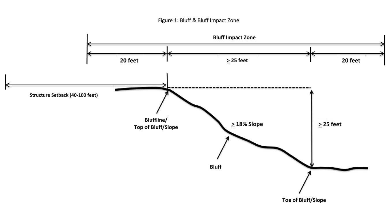
Bluff.
"Bluff" means a natural topographic feature having:
A.
a slope that rises at least 25 feet and the grade of the slope averages 18 percent or greater, measured over a horizontal distance of 25 feet, as follows:
(1)
where the slope begins above the ordinary high water level, from the toe of the slope to the top of the slope; or
(2)
where the slope begins below the ordinary high water level, from the ordinary high water level to the top of the slope. See Figure 1; or
B.
a natural escarpment or cliff with a slope that rises at least ten feet above the ordinary high water level or toe of the slope, whichever is applicable, to the top of the slope, with a slope of 75 degrees or greater.
Subp. 9.
Bluff impact zone.
"Bluff impact zone" means the bluff and land within 20 feet of the bluff. See Figure 1.
Subp. 10.
Bluffline.
"Bluffline" means a line delineating the top of the bluff. More than one bluffline may be encountered proceeding landward from the river. See also subpart 9, Figure 1, and subpart 78, "top of the bluff."
Subp. 11.
Buildable area.
"Buildable area" means the area upon which structures may be placed on a lot or parcel of land and excludes land areas needed to meet requirements for setback, rights-of-way, bluff impact zones, historic properties, wetlands, designated floodways, land below the ordinary high water level of public waters, and other areas restricted from development by local ordinance.
Subp. 12.
Building.
"Building" means a structure with two or more outside rigid walls and a fully secured roof and affixed to a permanent site.
Subp. 13.
Certificate of compliance.
"Certificate of compliance" means a document, written after a compliance inspection, certifying that the development is in compliance with applicable requirements at the time of the inspection.
Subp. 15.
Conditional use.
"Conditional use" has the meaning given under Minnesota Statutes, section 394.22.
Subp. 16.
Conservation design.
"Conservation design" means a pattern of subdivision that is characterized by grouping lots within a portion of a parcel, where the remaining portion of the parcel is permanently protected as open space.
Subp. 17.
Conventional subdivision.
"Conventional subdivision" means a pattern of subdivision that is characterized by lots that are spread regularly throughout a parcel in a lot and block design.
Subp. 18.
Deck.
"Deck" means a horizontal, unenclosed, aboveground level structure open to the sky, with or without attached railings, seats, trellises, or other features, attached or functionally related to a principal use or site.
Subp. 20.
Development.
"Development" has the meaning given under Minnesota Statutes, section 116G.03.
Subp. 21.
Discretionary action.
"Discretionary action" means an action under this chapter related to land use that requires a public hearing by local ordinance or statute, such as preliminary plats, final subdivision plats, planned unit developments, conditional use permits, interim use permits, variances, appeals, and rezonings.
Subp. 23.
Electric power facilities.
"Electric power facilities" means equipment and associated facilities for generating electric power as identified and defined under Minnesota Statutes, section 216E.01, and devices for converting wind energy to electrical energy.
Subp. 24.
Essential services.
"Essential services" means underground or overhead gas, electrical, communications, steam, or water distribution, collection, supply, or disposal systems, including stormwater. Essential services includes poles, wires, mains, drains, pipes, conduits, cables, fire alarm boxes, traffic signals, hydrants, navigational structures, aviation safety facilities, or other similar equipment and accessories in conjunction with the systems. Essential services does not include buildings, treatment works as defined in Minnesota Statutes, section 115.01, electric power facilities, or transmission services.
Subp. 27.
Hard-surface trail.
"Hard-surface trail" means a trail surfaced in asphalt, crushed aggregate, or other hard surface, for multipurpose use, as determined by local, regional, or state agency plans.
Subp. 28.
Historic property.
"Historic property" means an archaeological site, standing structure, site, district, or other property that is:
A.
listed in the National Register of Historic Places or the State Register of Historic Places or locally designated as a historic site under Minnesota Statutes, chapter 471;
B.
determined to meet the criteria for eligibility to the National Register of Historic Places or the State Register of Historic Places; or
C.
an unplatted cemetery that falls under the provisions of Minnesota Statutes, chapter 307, in consultation with the Office of the State Archeologist.
Subp. 29.
Impervious surface.
"Impervious surface" means a constructed hard surface that either prevents or retards the entry of water into the soil and causes water to run off the surface in greater quantities and at an increased rate of flow than prior to development. Examples are rooftops, decks, sidewalks, patios, parking lots, storage areas, roads, and driveways, including those with concrete, asphalt, or gravel surfaces.
Subp. 30.
Intensive vegetation clearing.
"Intensive vegetation clearing" means removal of all or a majority of the trees or shrubs in a contiguous patch, strip, row, or block.
Subp. 31.
Interim use.
"Interim use" has the meaning given under Minnesota Statutes, sections 394.303 and 462.3597.
Subp. 32.
Land alteration.
"Land alteration" means an activity that exposes the soil or changes the topography, drainage, or cross section of the land, excluding gardening or similar minor soil disturbances.
Subp. 34.
Local park agencies.
"Local park agencies" means the Minneapolis Park and Recreation Board and the Three Rivers Park District.
Subp. 36.
Lot width.
"Lot width" means the shortest distance between lot lines measured at both the ordinary high water level and at the required structure setback from the ordinary high water level.
Subp. 39.
Native plant community.
"Native plant community" means a plant community that has been identified as part of the Minnesota biological survey or biological survey issued or adopted by a local, state, or federal agency.
Subp. 40.
Natural-surface trail.
"Natural-surface trail" means a trail composed of native soil and rock or compacted granular stone, primarily intended for hiking, equestrian, or mountain bike use, as determined by local, regional, or state agency plans.
Subp. 41.
Natural vegetation.
"Natural vegetation" means any combination of ground cover, understory, and tree canopy that, while it may have been altered by human activity, continues to stabilize soils, retain and filter runoff, provide habitat, and recharge groundwater.
Subp. 42.
Nonconformity.
"Nonconformity" has the meaning given under Minnesota Statutes, section 394.22.
Subp. 43.
Nonmetallic mining.
"Nonmetallic mining" means construction, reconstruction, repair, relocation, expansion, or removal of any facility for the extraction, stockpiling, storage, disposal, or reclamation of nonmetallic minerals such as stone, sand, and gravel. Nonmetallic mining does not include ancillary facilities such as access roads, bridges, culverts, and water level control structures. For purposes of this subpart, "facility" includes all mine pits, quarries, stockpiles, basins, processing structures and equipment, and any structures that drain or divert public waters to allow mining.
Subp. 44.
Off-premise advertising signs.
"Off-premise advertising signs" means those signs that direct attention to a product, service, business, or entertainment venue that is not exclusively related to the premises where the sign is located.
Subp. 45.
Ordinary high water level.
"Ordinary high water level" has the meaning given under Minnesota Statutes, section 103G.005.
Subp. 46.
Overlay district.
"Overlay district" means a zoning district that is applied over one or more previously established zoning districts, establishing additional or stricter standards and criteria for covered properties in addition to those of the underlying zoning district. Overlay districts are often used to protect historic features and natural resources such as shoreland or floodplain.
Subp. 48.
Patio.
"Patio" means a constructed hard surface located at ground level with no railings and open to the sky.
Subp. 49.
Picnic shelter.
"Picnic shelter" means a roofed structure open on all sides, accessory to a recreational use.
Subp. 50.
Planned unit development.
"Planned unit development" means a method of land development that merges zoning and subdivision controls, allowing developers to plan and develop a large area as a single entity, characterized by a unified site design, a mix of structure types and land uses, and phasing of development over a number of years. Planned unit development includes any conversion of existing structures and land uses that use this method of development.
Subp. 51.
Plat.
"Plat" has the meaning given under Minnesota Statutes, sections 505.01, subdivision 3, and 515B.2-110.
Subp. 52.
Port.
"Port" means a water transportation complex established and operated under the jurisdiction of a port authority according to Minnesota Statutes, chapter 458.
Subp. 53.
Primary conservation areas.
"Primary conservation areas" means key resources and features, including shore impact zones, bluff impact zones, floodplains, wetlands, gorges, areas of confluence with tributaries, natural drainage routes, unstable soils and bedrock, native plant communities, cultural and historic properties, significant existing vegetative stands, tree canopies, and other resources identified in local government plans.
Subp. 54.
Professional engineer.
"Professional engineer" means an engineer licensed to practice in Minnesota.
Subp. 55.
Public recreational facilities.
"Public recreational facilities" means recreational facilities provided by the state or a local government and dedicated to public use, including parks, scenic overlooks, observation platforms, trails, docks, fishing piers, picnic shelters, water access ramps, and other similar water-oriented public facilities used for recreation.
Subp. 56.
Public river corridor views.
"Public river corridor views" means views toward the river from public parkland, historic properties, and public overlooks, as well as views toward bluffs from the ordinary high water level of the opposite shore, as seen during the summer months.
Subp. 57.
Public transportation facilities.
"Public transportation facilities" means all transportation facilities provided by federal, state, or local government and dedicated to public use, such as roadways, transit facilities, railroads, and bikeways.
Subp. 58.
Public utilities.
"Public utilities" means electric power facilities, essential services, and transmission services.
Subp. 59.
Public waters.
"Public waters" has the meaning given under Minnesota Statutes, section 103G.005.
Subp. 60.
Readily visible.
"Readily visible" means land and development that are easily seen from the ordinary high water level of the opposite shore during summer months.
Subp. 61.
Resource agency.
"Resource agency" means a federal, state, regional, or local agency that engages in environmental, natural, or cultural resource protection or restoration activities, including planning, implementation, and monitoring.
Subp. 62.
Retaining wall.
"Retaining wall" means a vertical or nearly vertical structure constructed of mortar and rubble masonry, rock, or stone regardless of size, vertical timber pilings, horizontal timber planks with piling supports, sheet pilings, poured concrete, concrete blocks, or other durable material.
Subp. 63.
Riprap.
"Riprap" means coarse stones, boulders, cobbles, broken rock or concrete, or brick materials placed or constructed to armor shorelines, streambeds, bridge abutments, pilings, and other shoreline structures against scour or water or ice erosion.
Subp. 64.
River corridor boundary.
"River corridor boundary" means the boundary approved and adopted by the Metropolitan Council under Minnesota Statutes, section 116G.06, as approved and adopted by the legislature in Minnesota Statutes, section 116G.15, and as legally described in the State Register, volume 43, pages 508 to 519.
Subp. 65.
River-dependent use.
"River-dependent use" means the use of land for commercial, industrial, or utility purposes, where access to and use of a public water feature is an integral part of the normal conduct of business and where the use is dependent on shoreline facilities.
Subp. 66.
Selective vegetation removal.
"Selective vegetation removal" means removal of isolated individual trees or shrubs that are not in a contiguous patch, strip, row, or block and that does not substantially reduce the tree canopy or understory cover.
Subp. 68.
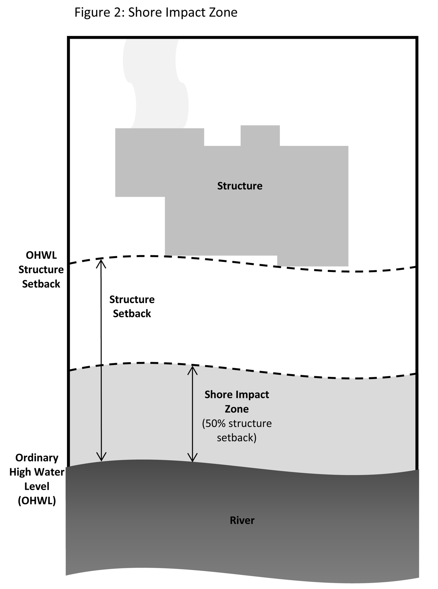
Shore impact zone.
"Shore impact zone" means land located between the ordinary high water level of public waters and a line parallel to it at a setback of 50 percent of the required structure setback or, for areas in agricultural use, 50 feet landward of the ordinary high water level. See Figure 2.
Subp. 69.
Shoreline facilities.
"Shoreline facilities" means facilities that require a location adjoining public waters for ingress and egress, loading and unloading, and water intake and outflow, such as barge facilities, port facilities, commodity loading and unloading equipment, watercraft lifts, marinas, short-term watercraft mooring facilities for patrons, and water access ramps. Structures that would be enhanced by a shoreline location, but do not require a location adjoining public waters as part of their function, are not shoreline facilities, such as restaurants, bait shops, and boat dealerships.
Subp. 70.
Special purpose unit of government.
"Special purpose unit of government" means the University of Minnesota; the St. Paul Port Authority; watershed management organizations established under Minnesota Statutes, chapter 103B; watershed districts established under Minnesota Statutes, chapter 103D; and any other unit of government other than those listed in subparts 33 and 71.
Subp. 71.
State or regional agency.
"State or regional agency" means the Metropolitan Airports Commission, Minnesota Historical Society, University of Minnesota, Department of Natural Resources, Department of Transportation, and Metropolitan Council and other state agencies.
Subp. 72.
Steep slope.
"Steep slope" means a natural topographic feature with an average slope of 12 to 18 percent, measured over a horizontal distance equal to or greater than 50 feet, and any slopes greater than 18 percent that are not bluffs.
Subp. 74.
Structure.
"Structure" means a building, sign, or appurtenance thereto, except for aerial or underground utility lines, such as sewer, electric, telephone, telegraph, or gas lines, and utility line towers, poles, and other supporting appurtenances.
Subp. 75.
Subdivision.
"Subdivision" has the meaning given under Minnesota Statutes, section 462.352.
Subp. 76.
Subsurface sewage treatment system.
"Subsurface sewage treatment system" has the meaning given under part 7080.1100.
Subp. 77.
Toe of the bluff.
"Toe of the bluff" means a line along the bottom of a bluff, requiring field verification, such that the slope above the line exceeds 18 percent and the slope below the line is 18 percent or less, measured over a horizontal distance of 25 feet. See subpart 9, Figure 1.
Subp. 78.
Top of the bluff.
"Top of the bluff" means a line along the top of a bluff, requiring field verification, such that the slope below the line exceeds 18 percent and the slope above the line is 18 percent or less, measured over a horizontal distance of 25 feet. See subpart 9, Figure 1.
Subp. 79.
Transmission services.
"Transmission services" means:
A.
electric power lines, cables, pipelines, or conduits that are:
(1)
used to transport power between two points, as identified and defined under Minnesota Statutes, section 216E.01, subdivision 4; or
(2)
for mains or pipelines for gas, liquids, or solids in suspension, used to transport gas, liquids, or solids in suspension between two points; and
Subp. 80.
Treeline.
"Treeline" means the more or less continuous line formed by the tops of trees in a wooded area when viewed from a particular point. The treeline is determined during all seasons as if under full foliage.
Subp. 81.
Twin Cities metropolitan area.
"Twin Cities metropolitan area" is the area over which the Metropolitan Council has jurisdiction according to Minnesota Statutes, section 473.121, subdivision 2.
Subp. 83.
Water access ramp.
"Water access ramp" means a boat ramp, carry-down site, boarding dock, and approach road, or other access that allows launching and removal of a boat, canoe, or other watercraft with or without a vehicle and trailer.
Subp. 84.
Water-oriented accessory structure.
"Water-oriented accessory structure" means a small building or other improvement, except stairways, fences, docks, and retaining walls, that, because of the relationship of its use to public waters, needs to be located closer to public waters than the normal structure setback. Examples include gazebos, screen houses, fish houses, pump houses, and detached decks and patios.
History:
41 SR 799; 43 SR 778
Published Electronically:
January 30, 2024
Official Publication of the State of Minnesota
Revisor of Statutes