
Minnesota Administrative Rules
CHAPTER 6105, WILD, SCENIC, AND RECREATIONAL RIVERS
DEPARTMENT OF NATURAL RESOURCES
| Part | Title |
|---|---|
| STATEWIDE STANDARDS AND CRITERIA | |
| 6105.0010 | POLICY. |
| 6105.0020 | PURPOSE. |
| 6105.0030 | SCOPE. |
| 6105.0040 | DEFINITIONS. |
| 6105.0050 | SEVERABILITY. |
| 6105.0060 | RIVERS ELIGIBLE FOR INCLUSION IN RIVER SYSTEM. |
| 6105.0070 | PROCEDURE FOR INCLUDING A RIVER: MANAGEMENT PLANS. |
| 6105.0080 | LAND USE. |
| 6105.0090 | LAND USE DISTRICTS. |
| 6105.0100 | USE WITHIN LAND USE DISTRICTS. |
| 6105.0110 | ZONING DIMENSIONS. |
| 6105.0120 | SANITARY STANDARDS. |
| 6105.0130 | WATERSHED MANAGEMENT AND FLOOD CONTROL STRUCTURES. |
| 6105.0140 | SUBDIVISIONS. |
| 6105.0150 | VEGETATIVE CUTTING. |
| 6105.0160 | GRADING AND FILLING. |
| 6105.0170 | PERMITS FOR UTILITY TRANSMISSION CROSSINGS. |
| 6105.0180 | STANDARDS AND CRITERIA FOR UTILITY TRANSMISSION CROSSINGS OF LANDS WITHIN THE JURISDICTION OF THE LOCAL AUTHORITY. |
| 6105.0190 | PUBLIC ROAD PERMITS. |
| 6105.0200 | STANDARDS AND CRITERIA FOR CONSTRUCTION OF NEW PUBLIC ROADS OR RECONSTRUCTION OF EXISTING ROADS. |
| 6105.0210 | PUBLIC USE OF WATERS AND LANDS WITHIN WILD, SCENIC, AND RECREATIONAL RIVER LAND USE DISTRICTS. |
| 6105.0220 | IMPLEMENTATION OF PROPOSED MANAGEMENT PLAN. |
| 6105.0230 | REVIEWS AND CERTIFICATION OF LOCAL LAND USE DECISIONS. |
| 6105.0240 | REVIEW OF APPLICATIONS FOR CONDITIONAL USE PERMITS. |
| 6105.0250 | COPIES OF PLATS SUPPLIED TO COMMISSIONER. |
| LOWER SAINT CROIX WATER SURFACE USE | |
| 6105.0300 | STATUTORY AUTHORITY AND PURPOSE. |
| 6105.0310 | SCOPE. |
| 6105.0320 | DEFINITIONS. |
| 6105.0330 | RESTRICTED SPEED ZONES. |
| 6105.0340 | WATER SKIING. |
| 6105.0350 | PENALTY. |
| LOWER SAINT CROIX NATIONAL SCENIC RIVERWAY | |
| 6105.0351 | STATEMENT OF POLICY. |
| 6105.0352 | SCOPE. |
| 6105.0353 | JURISDICTION. |
| 6105.0354 | DEFINITIONS. |
| 6105.0360 | ST. CROIX RIVERWAY DESIGNATION AND ESTABLISHMENT OF DISTRICTS. |
| 6105.0370 | USE STANDARDS AND CRITERIA. |
| 6105.0380 | DIMENSIONAL STANDARDS AND CRITERIA. |
| 6105.0390 | SANITARY STANDARDS AND CRITERIA. |
| 6105.0400 | SUBDIVISIONS. |
| 6105.0410 | MARINAS. |
| 6105.0420 | ALTERATIONS IN PUBLIC WATERS. |
| 6105.0430 | TRANSMISSION SERVICES. |
| 6105.0440 | PUBLIC ROADS. |
| SAINT CROIX RIVERWAY ORDINANCE ADMINISTRATION AND ENFORCEMENT | |
| 6105.0500 | JOINT EXERCISE OF POWERS. |
| 6105.0510 | LOCAL PERMIT PROCEDURES. |
| 6105.0520 | VARIANCES. |
| 6105.0530 | PUBLIC HEARINGS. |
| 6105.0540 | CERTIFYING CERTAIN ACTIONS. |
| 6105.0550 | IMPLEMENTATION AND ENFORCEMENT ASSISTANCE. |
| KETTLE RIVER MANAGEMENT PLAN | |
| 6105.0600 | STATUTORY AUTHORITY. |
| 6105.0605 | DESIGNATION OF RIVER. |
| 6105.0610 | SCOPE. |
| 6105.0620 | PURPOSE. |
| 6105.0625 | CLASSIFICATION OF RIVER. |
| 6105.0630 | RECREATION MANAGEMENT. |
| 6105.0640 | LAND MANAGEMENT. |
| 6105.0650 | ADMINISTRATION OF PLAN. |
| 6105.0700 | [Repealed, 12 SR 365] |
| 6105.0710 | RECREATION MANAGEMENT MAPS. |
| 6105.0720 | PROPERTY DESCRIPTIONS AND ACREAGE. |
| 6105.0730 | LAND USE DISTRICT ACREAGE. |
| 6105.0740 | SCENIC EASEMENT ACREAGE. |
| 6105.0750 | ACQUISITION ACREAGE. |
| 6105.0760 | TYPICAL TRAIL DESIGN. |
| MISSISSIPPI RIVER MANAGEMENT PLAN | |
| 6105.0800 | DESIGNATION OF RIVER. |
| 6105.0810 | STATUTORY AUTHORITY. |
| 6105.0820 | SCOPE. |
| 6105.0830 | CLASSIFICATION: SCENIC RIVER. |
| 6105.0840 | CLASSIFICATION: RECREATIONAL. |
| 6105.0850 | RECREATION MANAGEMENT. |
| 6105.0860 | LAND MANAGEMENT. |
| 6105.0870 | ADMINISTRATION OF MANAGEMENT PLAN. |
| 6105.0880 | INTERAGENCY RECOMMENDATIONS. |
| 6105.0900 | LAND MANAGEMENT TOTALS. |
| 6105.0910 | LAND USE DISTRICT ACREAGES. |
| 6105.0911 | [Amendment merged into 6105.0910, 9 SR 2341] |
| 6105.0920 | SCENIC EASEMENTS. |
| 6105.0930 | FEE ACQUISITIONS. |
| 6105.0940 | SITES TYPICAL. |
| 6105.0950 | LAND MANAGEMENT MAPS. |
| 6105.0960 | RECREATION MANAGEMENT MAPS. |
| NORTH FORK OF CROW RIVER IN MEEKER COUNTY | |
| 6105.1000 | DESIGNATION OF RIVER. |
| 6105.1010 | STATUTORY AUTHORITY. |
| 6105.1020 | SCOPE. |
| 6105.1030 | CLASSIFICATION: RECREATIONAL RIVER. |
| 6105.1040 | LAND USE MANAGEMENT. |
| 6105.1050 | LAND ACQUISITION. |
| 6105.1060 | RECREATION MANAGEMENT. |
| 6105.1070 | ADMINISTRATION OF MANAGEMENT PLAN. |
| 6105.1080 | RECOMMENDATIONS FOR COOPERATION WITH GOVERNMENTAL UNITS. |
| 6105.1090 | LAND USE DISTRICT ACREAGE PER RIVER MILE. |
| 6105.1100 | PROPERTY DESCRIPTIONS: LAND USE DISTRICT. |
| 6105.1110 | PROPERTY DESCRIPTIONS: SCENIC AREAS. |
| 6105.1120 | CROW RIVER RECREATION MANAGEMENT PLAN. |
| 6105.1130 | SITES TYPICAL. |
| MINNESOTA RIVER MANAGEMENT PLAN | |
| 6105.1200 | DESIGNATION OF RIVER. |
| 6105.1210 | STATUTORY AUTHORITY. |
| 6105.1220 | SCOPE. |
| 6105.1230 | SEVERABILITY. |
| 6105.1240 | STIPULATION. |
| 6105.1250 | RIVER CLASSIFICATIONS. |
| 6105.1260 | LAND MANAGEMENT; ZONING. |
| 6105.1270 | LAND ACQUISITION. |
| 6105.1280 | RECREATION MANAGEMENT. |
| 6105.1290 | LAND USE DISTRICT DESCRIPTIONS AND ACREAGES. |
| 6105.1291 | [Amendment merged into 6105.1290, 11 SR 454] |
| 6105.1300 | SCENIC EASEMENT DESCRIPTIONS AND ACREAGES. |
| 6105.1310 | FEE TITLE DESCRIPTIONS AND ACREAGES. |
| 6105.1320 | PRIMITIVE CAMPSITE. |
| 6105.1330 | REST AREA. |
| 6105.1340 | BOAT ACCESS. |
| 6105.1350 | CANOE ACCESS. |
| 6105.1360 | CAMPGROUND. |
| 6105.1370 | TRAIL DESIGN. |
| RUM RIVER MANAGEMENT PLAN | |
| 6105.1400 | DESIGNATION OF RIVER. |
| 6105.1410 | STATUTORY AUTHORITY. |
| 6105.1420 | SCOPE. |
| 6105.1430 | CLASSIFICATION OF RIVER. |
| 6105.1440 | LAND USE MANAGEMENT. |
| 6105.1450 | LAND ACQUISITION. |
| 6105.1460 | RECREATION MANAGEMENT. |
| 6105.1470 | ADMINISTRATION OF MANAGEMENT PLAN. |
| 6105.1480 | LAND USE DISTRICT DESCRIPTIONS STARTING FROM MILE 145.7 AT OGECHIE LAKE SPILLWAY. |
| 6105.1490 | SCENIC EASEMENT ACQUISITION STARTING AT MILE 145.7. |
| 6105.1500 | FEE TITLE DESCRIPTIONS. |
| CANNON RIVER MANAGEMENT PLAN | |
| 6105.1550 | DESIGNATION OF RIVER. |
| 6105.1560 | STATUTORY AUTHORITY. |
| 6105.1570 | SCOPE. |
| 6105.1580 | DEFINITION OF NORMAL HIGH WATER MARK. |
| 6105.1590 | SEVERABILITY. |
| 6105.1600 | CLASSIFICATION OF RIVERS. |
| 6105.1610 | LAND USE MANAGEMENT. |
| 6105.1620 | LAND ACQUISITION. |
| 6105.1630 | RECREATION MANAGEMENT IN GENERAL. |
| 6105.1640 | RECREATIONAL USES. |
| 6105.1650 | MAINTENANCE OF RECREATIONAL FACILITIES. |
| 6105.1660 | ENFORCEMENT OF USER RULES. |
| 6105.1670 | ADMINISTRATION OF THE MANAGEMENT PLAN. |
| 6105.1680 | LAND USE DISTRICT LEGAL DESCRIPTIONS. |
| 6105.1681 | [Amendment merged into 6105.1680, 9 SR 296] |
| 6105.1690 | TYPICAL SIGNS. |
| 6105.1700 | TYPICAL SITES. |
STATEWIDE STANDARDS AND CRITERIA
6105.0010 POLICY.
It is in the interest of present and future generations to preserve and protect the outstanding scenic, recreational, natural, historical, and scientific values of certain Minnesota rivers and their adjacent lands. Accordingly, the commissioner of natural resources does hereby provide standards and criteria for the preservation, protection, and management of such rivers, as authorized by Laws of Minnesota 1973, chapter 271.
Statutory Authority:
MS s 104.34
Published Electronically:
June 11, 2008
6105.0020 PURPOSE.
The standards and criteria established in parts 6105.0010 to 6105.0250 will provide minimum statewide requirements for the selection, classification, management, and control of wild, scenic, and recreational rivers and their land use districts.
Statutory Authority:
MS s 104.34
Published Electronically:
June 11, 2008
6105.0030 SCOPE.
The standards and criteria for wild, scenic, and recreational rivers hereby established in parts 6105.0010 to 6105.0250 shall pertain to public waters and to public and private lands within the land use districts as defined in the management plan.
The extent of the lands so covered is a maximum of 320 acres per each mile of river on both sides (not each side) of those rivers or river segments which the commissioner of natural resources has designated as components of the Minnesota wild and scenic rivers system.
All state, local, and special governmental units, councils, commissions, boards, districts, agencies, departments, and other authorities shall exercise their powers so as to further the purpose of the Minnesota Wild and Scenic Rivers Act and management plans adopted thereunder.
Land owned by the state, its agencies and subdivisions shall be administered in accordance with the management plan. No land so owned within the land use district shall be transferred if the commissioner determines such transfer is inconsistent with the plan.
In case of conflict between a provision of the Minnesota Wild and Scenic Rivers Act of these parts and some other law of this state or provisions of existing local ordinances, the more protective provision shall apply.
Statutory Authority:
MS s 104.34
Published Electronically:
June 11, 2008
6105.0040 DEFINITIONS.
Subpart 1.
Shall; measurement of distances.
For the purpose of these parts, certain terms or words used herein shall be interpreted as follows: the word "shall" is mandatory, not permissive. All distances unless otherwise specified shall be measured horizontally.
Subp. 2.
Agricultural use.
"Agricultural use" means the management of land for production of farm crops such as vegetables, fruit trees, grain, and other crops, and their storage on the area, as well as for the raising thereon of farm poultry, domestic pets, and domestic farm animals.
Subp. 3.
Bluffline.
"Bluffline" means a line along the top of a slope connecting the points at which the slope becomes less than 13 percent. This applies to those slopes within the land use district which are beyond the setback provision from the normal high water mark.
Subp. 4.
Building line.
"Building line" means that line measured across the width of the lot at the point where the main structure is placed in accordance with setback provisions.
Subp. 5.
Campground.
"Campground" means an area accessible by vehicle and containing campsites or camping spurs for tent and trailer camping.
Subp. 7.
Cluster development.
"Cluster development" means a pattern of subdivision development which places housing units into compact groupings while providing a network of commonly owned or dedicated open space.
Subp. 8.
Commissioner.
"Commissioner" means the commissioner of the Department of Natural Resources.
Subp. 9.
Conditional use.
"Conditional use" means a use of land which is permitted within a zoning district only when allowed by the county board of commissioners or their legally designated agent after a public hearing, if certain conditions are met which eliminate or minimize the incompatibility with other permitted uses of the district.
Subp. 10.
Essential services.
"Essential services" means underground or overhead gas, electrical, steam, or water distribution systems; collection, communication, supply, or disposal systems, including poles, wires, mains, drains, sewers, pipes, conduits, cables, fire alarm boxes, traffic signals, hydrants, or other similar equipment and accessories in conjunction therewith; but not including buildings or transmission services.
Subp. 11.
Forestry.
"Forestry" means the management, including logging, of a forest, woodland, or plantation and related research and educational activities, including the construction, alteration, or maintenance of woodroads, skidways, landings, and fences.
Subp. 12.
Land use district.
"Land use district" means those lands designated by the commissioner as the protected land corridor along those rivers or river segments which the commissioner has designated as components of the Minnesota wild and scenic rivers system. The boundaries of such land use district shall include not more than 320 acres per each mile of river on both sides (not each side) of the river.
Subp. 13.
Mining operation.
"Mining operation" means the removal from the land of stone, sand and gravel, coal, salt, iron, copper, nickel, granite, petroleum products, or other material for commercial, industrial, or governmental purposes.
Subp. 14.
Nonconforming use.
"Nonconforming use" means any use of land established before the effective date of a county or local ordinance which does not conform to the use restrictions of a particular zoning district. This should not be confused with substandard dimensions of a conforming use.
Subp. 15.
Normal high water mark.
"Normal high water mark" means a mark delineating the highest water level which has been maintained for a sufficient period of time to leave evidence upon the landscape. In areas where the normal high water mark is not evident, setbacks shall be measured from the stream bank.
Subp. 16.
Open space recreational uses.
"Open space recreational uses" means recreation use particularly oriented to and utilizing the outdoor character of an area; including hiking and riding trails, primitive campsites, campgrounds, waysides, parks, and recreation areas.
Subp. 17.
Primitive campsites.
"Primitive campsites" means an area that consists of individual remote campsites accessible only by foot or water.
Subp. 18.
Scenic easement.
"Scenic easement" means an interest in land, less than the fee title, which limits the use of the land for the purpose of protecting the scenic, recreational, or natural characteristics of wild, scenic, or recreational river areas. Unless otherwise expressly and specifically provided by the parties, such easement shall be: perpetually held for the benefit of the people of Minnesota; specifically enforceable by its holder or any beneficiary; and binding on the holder of the servient estate, the holder's heirs, successors, and assigns. Unless specifically provided by the parties, no such easement shall give the holder or any beneficiary the right to enter on the land except for enforcement of the easement.
Subp. 20.
Setback.
"Setback" means the minimum horizontal distance between a structure and the normal high water mark or between a structure and a road or highway.
Subp. 21.
Sewage disposal system.
"Sewage disposal system" means any system for the collection, treatment, and dispersion of sewage including but not limited to septic tanks, soil absorption systems, and drain fields.
Subp. 22.
Single-family dwelling.
"Single-family dwelling" means a detached building containing one dwelling unit.
Subp. 23.
Structure.
"Structure" means any building, sign, or appurtenance thereto, except aerial or underground utility lines, such as sewer, electric, telephone, telegraph, or gas lines, including towers, poles, and other supporting appurtenances.
Subp. 24.
Subdivision.
"Subdivision" means improved or unimproved land or lands which are divided for the purpose of ready sale or lease, or divided successively within a five-year period for the purpose of sale or lease, into three or more lots or parcels of less than five acres each, contiguous in area and which are under common ownership or control.
Subp. 25.
Substandard use.
"Substandard use" means any use of shorelands existing prior to the date of enactment or amendment of a county or local ordinance which is permitted within the applicable land use district but does not meet the minimum lot area, length of water frontage, structure setbacks, or other dimensional standards of the ordinance.
Subp. 26.
Variance.
"Variance" means a modification or variation of the provisions of the local ordinance where it is determined that, by reason of exceptional circumstances, the strict enforcement of any provision of the local ordinance would cause unnecessary hardship, or that strict conformity with the provisions of the local ordinance would be unreasonable, impractical, or not feasible under the circumstances. This shall be evaluated according to the provisions contained in parts 6105.0220 to 6105.0250.
Subp. 27.
Watershed management or flood control structure.
"Watershed management or flood control structure" means a dam, floodwall, wing dam, dike, diversion channel, or an artificially deepened or widened stream channel following the same or approximately the same course as the natural channel, or any other structure for altering or regulating the natural flow condition of a river or stream. The term "watershed management or flood control structure" does not include pilings, retaining walls, gabion baskets, rock riprap, or other facilities intended primarily to prevent erosion and which must be authorized by permit from the commissioner.
Subp. 28.
Wetland.
"Wetland" means land which is annually subject to periodic or continual inundation by water and commonly referred to as a bog, swamp, or marsh.
Statutory Authority:
MS s 104.34
History:
17 SR 1279
Published Electronically:
June 11, 2008
6105.0050 SEVERABILITY.
The provisions of these rules shall be severable, and the invalidity of any paragraph, subparagraph, or subdivision thereof shall not make void any other paragraph, subparagraph, subdivision, or any other part.
Statutory Authority:
MS s 104.34
Published Electronically:
June 11, 2008
6105.0060 RIVERS ELIGIBLE FOR INCLUSION IN RIVER SYSTEM.
Subpart 1.
General characterization and classification.
To be eligible for inclusion in the Minnesota wild and scenic rivers system, a river or segment of a river, and its adjacent lands must possess outstanding scenic, recreational, natural, historical, scientific, or similar values. The river or its segments shall be classified into one or more of the three classes of rivers: wild, scenic, and recreational. Each river shall be managed so as to preserve and protect the values which qualify it for designation and classification.
Subp. 2.
Wild rivers.
Wild rivers are those that exist in a free-flowing state with excellent water quality and with adjacent lands that are essentially primitive.
A.
"Free-flowing" means existing in natural condition without significant artificial modification such as impoundment, diversion, or straightening. The existence, however, of low dams, diversion works, or other minor structures shall not automatically bar its inclusion as a wild, scenic, or recreational river.
B.
"Excellent water quality" means that the water quality is in or approaches natural condition with no significant evidence of human activities.
C.
"Adjacent lands that are essentially primitive" means that the river's adjacent lands should possess a wilderness or natural-like appearance. These adjacent lands should be substantially free of habitation and other evidence of human intrusion. However, the existence of a few unobtrusive structures along the river would not bar a river from wild river classification nor would a limited amount of domestic livestock grazing and pasture land, and cropland developed for the production of hay.
Wild rivers should not be paralleled by conspicuous and well-traveled roads or railroads. Short, inconspicuous, and well-screened stretches would not bar a river from wild river classification, nor would a bridge or utility crossings.
Subp. 3.
Scenic rivers.
Scenic rivers are those rivers that exist in a free-flowing state and with adjacent lands that are largely undeveloped.
B.
"Adjacent lands that are largely undeveloped" means that the adjacent lands still present an overall natural character, but in places may have been developed for agricultural, residential, or other land uses. Small communities that are limited to short reaches of the total area would not bar a river from scenic river classification.
Although roads and railroads may occasionally bridge certain rivers, this will not bar such rivers from scenic river classification, nor will short stretches of conspicuous roads and railroads and longer stretches of inconspicuous and well screened roads or railroads paralleling the river.
Subp. 4.
Recreational rivers.
Recreational rivers are those rivers that may have undergone some impoundment or diversion in the past and that may have adjacent lands which are considerably developed, but that are still capable of being managed so as to further the purposes of this act.
A.
"May have undergone some impoundment or diversion in the past" means that there may be preexisting water resource development and diversions having an environmental impact greater than that described for wild and scenic rivers.
B.
"May have adjacent lands that are considerably developed" means that the bordering lands may have already been developed for a full range of agricultural or other land uses. Recreational rivers also may be readily accessible by preexisting roads or railroads.
Statutory Authority:
MS s 104.34
History:
17 SR 1279
Published Electronically:
June 11, 2008
6105.0070 PROCEDURE FOR INCLUDING A RIVER: MANAGEMENT PLANS.
Subpart 1.
In general.
For each river proposed to be included in the wild and scenic rivers system, the commissioner shall prepare a management plan. The plan shall:
A.
give emphasis to the preservation and protection of the area's scenic, recreational, natural, historic, and similar values;
B.
place no unreasonable restrictions upon compatible, preexisting, economic uses of particular tracts of land.
Subp. 2.
Contents of plan.
Each management plan shall include:
B.
The proposed land use district boundaries which shall not exceed 320 acres per each mile of river on both sides (not each side) of the river.
C.
The proposed methods for preserving the river and its adjacent lands.
Land use controls, applied through local zoning ordinances, will be employed to preserve and protect the values of the river which justified its selection and classification.
Scenic easements or fee title to land may be acquired when preservation dictates stricter limits on shoreland development than land use controls can impose.
Fee ownership, or, when sufficient, use easements, may be acquired for campsites, accesses, launch areas, trails, and other public uses of land.
The commissioner can acquire fee and lesser interests in land by purchase, grant, gift, devise, exchange, or lease.
Statutory Authority:
MS s 104.34
Published Electronically:
June 11, 2008
6105.0080 LAND USE.
In order to preserve and protect those rivers and adjacent lands which possess outstanding scenic, recreational, natural, historical, scientific, and similar values, to reduce the effects of overcrowding and poorly planned development of such adjacent lands, to prevent pollution, to provide ample space on lots for sanitary facilities, to preserve natural beauty and quietude, to maintain property values, and to promote the general welfare, land use ordinances and official zoning district maps shall be enacted or amended by the county or municipality to comply with the management plan promulgated for lands within the jurisdiction of the local authority.
Statutory Authority:
MS s 104.34
Published Electronically:
June 11, 2008
6105.0090 LAND USE DISTRICTS.
Statutory Authority:
MS s 104.34
Published Electronically:
June 11, 2008
6105.0100 USE WITHIN LAND USE DISTRICTS.
Subpart 1.
Nonconforming uses.
All uses in existence prior to the effective date of enactment or amendment of the ordinance which do not conform to the use restrictions of the newly established land use district are nonconforming uses. Under the authority permitted by law, local authorities may adopt provisions to regulate and control, reduce the number or extent of, or gradually eliminate nonconforming uses. Local authorities shall provide for the gradual elimination of sanitary facilities inconsistent with part 6120.1300, subpart 3, items B, C, and E over a period of time not to exceed five years from the date of enactment of the local ordinance.
Subp. 2.
Substandard uses.
All uses in existence prior to the effective date of enactment or amendment of the ordinance which are permitted uses within the newly established land use district, but do not meet the minimum lot area, setbacks, or other dimensional requirements of the ordinance are substandard uses. All substandard uses, except for substandard signs, shall be allowed to continue subject to the following conditions and exceptions:
A.
Any structural alteration or addition to a substandard use which will increase the substandard dimensions shall not be allowed.
B.
Each local authority shall provide for the gradual amortization of substandard signs over a period of time not to exceed five years from the enactment or amendment of the ordinance.
Subp. 3.
Permitted and conditional uses.
In the following table of uses P means permitted use, C means conditional use, and N means nonpermitted use.
Certain of the following uses are subject to the zoning dimension provisions and sanitary provisions in parts 6105.0110 and 6105.0120. All of the following uses are subject to the vegetative cutting provisions and the grading and filling provisions in parts 6105.0150 and 6105.0160.
| Land Use Districts | ||||
| Wild River | Scenic River | Rec. River | ||
| A. | Governmental campgrounds, subject to management plan specifications. | N | P | P |
| B. | Private campgrounds, subject to management plan specifications. | N | C | C |
| C. | Public accesses, road access type with boat launching facilities subject to management plan specifications. | N | P | P |
| D. | Public accesses, trail access type, subject to management plan specifications. | P | P | P |
| E. | Temporary docks. | C | C | P |
| F. | Other governmental open space recreational uses, subject to management plan specifications. | P | P | P |
| G. | Other private open space recreational uses, subject to management plan specifications. | C | C | C |
| H. | Agricultural uses. | P | P | P |
| I. | Single family residential uses. | P | P | P |
| J. | Forestry uses. | P | P | P |
| K. | Essential services. | P | P | P |
| L. | Sewage disposal systems. | P | P | P |
| M. | Private roads and minor public streets. | P | P | P |
| N. | Signs approved by federal, state, or local government which are necessary for public health and safety and signs indicating areas that are available, or not available, for public use. | P | P | P |
| O. | Signs not visible from the river that are not specified in N. | P | P | P |
| P. | Governmental resource management for improving fish and wildlife habitat; wildlife management areas; nature areas; accessory roads. | P | P | P |
| Q. | Underground mining that does not involve surface excavation in the land use district. | C | C | C |
| R. | Utility transmission power lines and pipelines, subject to the provisions of parts 6105.0170 and 6105.0180. | C | C | C |
| S. | Public roads, subject to the provisions in parts 6105.0190 and 6105.0200. | C | C | C |
All uses not listed as permitted or conditional uses shall not be allowed within the applicable land use district.
Statutory Authority:
MS s 104.34
Published Electronically:
June 11, 2008
6105.0110 ZONING DIMENSIONS.
Subpart 1.
Substandard lots.
Lots of record in the office of the county register of deeds or registrar of titles on the effective date of enactment or amendment of the local land use ordinance, which do not meet the requirements of this part shall be allowed as building sites provided the proposed use is consistent with the local ordinance and the sanitary provisions, part 6105.0120, and the zoning dimension provisions, part 6105.0110, are complied with to the greatest extent practicable.
If in a group of two or more contiguous lots under a single ownership any individual lot does not meet the lot width requirements of the local ordinance, such individual lot cannot be considered as a separate parcel of land for purposes of sale or development, but must be combined with adjacent lots under the same ownership so that the combination of lots will equal one or more parcels of land each meeting the lot width requirements of the local ordinance, or to the greatest extent practicable.
Subp. 2.
Lot size.
For lots platted or created by metes and bounds description, the minimum size shall be:
A.
for wild rivers, at least six acres in area, and at least 300 feet in width at the building line and at least 300 feet at the water line for lots abutting a wild river;
B.
for scenic rivers, at least four acres in area, and at least 250 feet in width at the building line and at least 250 feet at the water line for lots abutting a scenic river;
Subp. 3.
Structures.
Structures:
A.
Density of dwelling units. The density of dwelling units shall not exceed one dwelling unit per lot.
B.
Setback. Structures, except signs specified in part 6105.0100, subpart 3, item N, essential services, private roads, and minor public streets, shall be placed so as to satisfy all setback requirements of subitems (1) to (3):
(1)
From the normal high water mark: wild river, 200 feet; scenic river, 150 feet; recreational river, 100 feet.
(3)
From tributaries designated in the management plan: wild river, 100 feet; scenic river, 100 feet; recreational river, 100 feet.
C.
Placement of structures. Structures shall not be located on slopes greater than 13 percent unless such structures can be screened and sewage disposal system facilities can be installed so as to comply with the sanitary provisions in part 6105.0120.
Where a floodplain ordinance exists, no structure shall be located in the floodway of a stream as defined in Minnesota Statutes, section 103F.111, subdivision 5, and furthermore shall be placed at an elevation consistent with any such applicable floodplain management ordinances. Where no floodplain ordinances exist, the elevation to which the lowest floor of a structure, including a basement, shall be placed, shall be determined after an evaluation of available flood information and shall be consistent with the statewide standards and criteria for management of floodplain areas of Minnesota.
Published Electronically:
June 11, 2008
6105.0120 SANITARY STANDARDS.
The sanitary provision standards set forth in part 6120.1300 shall apply to wild, scenic, and recreational river land use districts. However, the provisions of part 6120.1300, subpart 3, item D are superseded by the following setback provisions for septic tank and soil absorption systems:
| Setback from the Normal High Water Mark | |
| Wild river | 150 feet |
| Scenic river | 100 feet |
| Recreational river | 75 feet |
| Tributaries | 75 feet |
Statutory Authority:
MS s 104.34
Published Electronically:
June 11, 2008
6105.0130 WATERSHED MANAGEMENT AND FLOOD CONTROL STRUCTURES.
Minnesota Statutes, section 103G.245, requires a permit from the commissioner of natural resources before any change is made in the course, current, or cross-section of public waters.
Published Electronically:
June 11, 2008
6105.0140 SUBDIVISIONS.
Subpart 1.
Land suitability.
No land may be subdivided which is held unsuitable by the local authority, or the commissioner, for the proposed use because of flooding, inadequate drainage, soil and rock formations with severe limitations for development, severe erosion potential, unfavorable topography, inadequate water supply or sewage disposal capabilities, or any other feature likely to be harmful to the health, safety, or welfare of the future residents of the proposed subdivision or of the community.
Subp. 2.
Subdivision standards.
The provisions otherwise set forth in parts 6105.0080 to 6105.0200 shall apply to all plats except planned cluster developments.
Subp. 3.
Planned cluster developments.
Local ordinances shall contain provisions for allowing planned cluster developments when the proposed clustering provides a means of preserving agricultural land, open space, woods, scenic views and other features of the natural environment. Smaller lot sizes than those permitted in part 6105.0110, subpart 2 may be allowed for planned cluster developments provided:
A.
Preliminary plans are approved by the commissioner of natural resources prior to their enactment by the local authority.
B.
Central sewage facilities are installed which at least meet the applicable standards, criteria, or rules of the Minnesota Department of Health and the Minnesota Pollution Control Agency.
C.
Open space is preserved. This may be accomplished through the use of restrictive deed covenants, public dedication, granting of scenic easements, or other methods.
Statutory Authority:
MS s 104.34
Published Electronically:
June 11, 2008
6105.0150 VEGETATIVE CUTTING.
Subpart 1.
In general.
On lands within 200 feet of the normal high water mark of wild rivers, 150 feet of the normal high water mark of scenic rivers, 100 feet of the normal high water mark of recreational rivers and lands within 100 feet of the normal high water mark of tributaries designated in the management plan and on lands 40 feet landward of the bluffline on wild rivers, 30 feet landward of the bluffline on scenic rivers, and 20 feet landward of the bluffline on recreational rivers, the following standards shall apply:
A.
Clear cutting, except for any authorized public services such as roads and utilities, shall not be permitted.
B.
Selective cutting of trees in excess of four inches in diameter at breast height is permitted provided that cutting is spaced in several cutting operations and a continuous tree cover is maintained, uninterrupted by large openings. In cases where the existing tree cover has been interrupted by large openings in the past, selective cutting should be performed so as to maintain a continuous tree cover in the remaining wooded areas.
C.
The above cutting provisions will not be deemed to prevent:
(1)
the removal of diseased or insect-infested trees, or of rotten or damaged trees that present safety hazards;
(2)
pruning understory vegetation, shrubs, plants, bushes, grasses, or from harvesting crops, or cutting suppressed trees or trees less than four inches in diameter at breast height.
Subp. 2.
Clear cutting restrictions.
Clear cutting anywhere in wild, scenic, or recreational river land use districts is subject to the following standards and criteria:
A.
Clear cutting shall not be used as a cutting method where soil, slope, or other watershed conditions are fragile and subject to injury.
B.
Clear cutting shall be conducted only where clear-cut blocks, patches, or strips are, in all cases, shaped and blended with the natural terrain.
D.
Where feasible all clear cuts shall be conducted between September 15 and May 15. If natural regeneration will not result in adequate vegetative cover, areas in which clear cutting is conducted shall be replanted to prevent erosion and to maintain the aesthetic quality of the area. Where feasible, replanting shall be performed in the same spring, or the following spring.
Statutory Authority:
MS s 104.34
Published Electronically:
June 11, 2008
6105.0160 GRADING AND FILLING.
Subpart 1.
In general.
Grading and filling in of the natural topography which is not accessory to a permitted or conditional use shall not be permitted in the land use district. Grading and filling in of the natural topography which is accessory to a permitted or conditional use shall be performed in a manner which minimizes earth moving, erosion, tree clearing, and the destruction of natural amenities and shall be controlled by the local ordinance.
Subp. 2.
Additional standards.
Grading and filling in of the natural topography shall also meet the following standards:
B.
temporary ground cover, such as mulch, is used and permanent ground cover, such as sod, is planted;
Subp. 3.
Excavation.
Excavation of material from, or filling in a wild, scenic, or recreational river, or construction of any permanent structures or navigational obstructions therein is prohibited, unless authorized by a permit from the commissioner pursuant to Minnesota Statutes, section 103G.245.
Subp. 4.
Draining or filling wetlands prohibited.
No state or local authority shall authorize the drainage or filling in of wetlands within wild, scenic, or recreational river land use districts.
Published Electronically:
June 11, 2008
6105.0170 PERMITS FOR UTILITY TRANSMISSION CROSSINGS.
Subpart 1.
Requirement.
All utility crossings (transmission and distribution) of wild, scenic, or recreational rivers, or of state lands within their land use districts which are under the control of the commissioner, require a permit from the commissioner pursuant to Minnesota Statutes, section 84.415 or 103G.245. In reviewing permit applications for such crossings, primary consideration shall be given to crossings that are proposed to be located with or adjacent to existing public facilities, such as roads and utilities.
Subp. 2.
Conditional use permit.
Utility transmission crossings of lands within the jurisdiction of the local authority within wild, scenic, or recreational river land use districts, require a conditional use permit from the local authority. Transmission means electric power, telephone, and telegraph lines, cables, or conduits which are used to transport large blocks of power between two points (with respect to electric power, generally, 69 kilovolts or more) or main or pipeline crossings for gas, liquids, or solids in suspension which are used to transport large amounts of gas, liquids, or solids in suspension between two points. A conditional use permit is not required for high voltage (200 kilovolts or greater) transmission lines under the control of the Environmental Quality Board, pursuant to Minnesota Statutes, section 216E.10.
"Distribution" means lines, cables, or conduits or mains or pipelines used to distribute power, water, gas, or other essential services to the utility company's customers. These are essential services. A conditional use permit is not required for essential services.
Published Electronically:
June 11, 2008
6105.0180 STANDARDS AND CRITERIA FOR UTILITY TRANSMISSION CROSSINGS OF LANDS WITHIN THE JURISDICTION OF THE LOCAL AUTHORITY.
Subpart 1.
Policy.
It is essential to regulate utility transmission crossings of lands within the jurisdiction of the local authority within wild, scenic, or recreational river land use districts in order to provide maximum protection and preservation of the natural environment and to minimize any adverse effects which may result from such utility crossings. These standards and criteria provide a basic framework of environmental considerations concerning such a proposed crossing. The considerations deal with route design, structure design, construction methods, safety considerations, and right-of-way maintenance.
Subp. 2.
Applicant requirements.
For each environmental consideration listed in these standards and criteria, the applicant shall indicate how the applicant is satisfying the consideration, where applicable, or if not, why not. In dealing with route design considerations the applicant must, where applicable, also supply data on relevant site conditions. The local authority shall issue a conditional use permit if the applicant shows that the applicant has satisfied, to the extent feasible, these environmental considerations.
In general, avoid wild, scenic, and recreational river land use districts, especially wild river land use districts, whenever practicable. But if there is no feasible alternative, the following standards and criteria shall apply.
Subp. 3.
Route design.
Route design:
A.
With regard to topography:
(4)
avoid creating tunnel vistas by, for example, building deflections into the route or using acceptable screening techniques.
B.
With regard to location, avoid entering areas within 200 feet of wild, scenic, and recreational rivers and avoid entering areas within 100 feet of designated tributaries with wild, scenic, or recreational river land use districts except where the utility has been authorized by the commissioner to cross wild, scenic, or recreational rivers or tributaries within their land use districts.
C.
With regard to vegetation:
(2)
run along fringe of forests rather than through them, but if it is necessary to route through forests, then utilize open areas in order to minimize destruction of commercial forest resources.
D.
With regard to soil characteristics:
(1)
avoid soils whose high susceptibility to erosion would create sedimentation and pollution problems during and after construction;
Subp. 4.
Structure design.
Structure design:
A.
With regard to locating the utility overhead or underground, primary considerations must be given to underground placement in order to minimize visual impact. If the proposal is for overhead placement, the applicant shall explain the economic, technological, or land characteristic factors, which make underground placement infeasible. Economic considerations alone shall not be the major determinant.
If overhead placement is necessary, the crossing should be hidden from view as much as practicable.
B.
With regard to the appearance of the structures, they shall be made as compatible as practicable with the natural area with regard to height and width, materials used, and color.
C.
With regard to the width of the right-of-way, the cleared portion of the right-of-way should be kept to a minimum.
Subp. 5.
Construction methods.
Construction methods:
A.
Construct across wetlands in the winter in order to minimize damage to vegetation, and in order to prevent erosion and sedimentation.
C.
Effective erosion and sedimentation control programs shall be conducted during all clearing, construction, or reconstruction operations in order to prevent the degradation of the river and adjacent lands.
Subp. 6.
Safety considerations.
Applicants must adhere to applicable federal and state safety regulations, both with regard to prevention (such as safety valves and circuit breakers) and with regard to emergency procedures in the event of failure (fire suppression, oil spill cleanup).
Subp. 7.
Right-of-way maintenance.
Right-of-way maintenance:
A.
If possible, natural vegetation of value to fish or wildlife, and which does not pose a hazard to or restrict reasonable use of the utility, shall be allowed to grow in the right-of-way.
B.
Where vegetation has been removed, new vegetation consisting of native grasses, herbs, shrubs, and trees, should be planted and maintained on the rights-of-way.
C.
Chemical control of vegetation is discouraged. But where such methods are justified, chemicals used and the manner of their use must be in accordance with rules and other requirements of all state and federal agencies with authority over the use.
History:
17 SR 1279
Published Electronically:
June 11, 2008
6105.0190 PUBLIC ROAD PERMITS.
Subpart 1.
Requirement.
A permit as established in Minnesota Statutes, section 103G.245, is required for the construction or reconstruction, removal, or abandonment of any road or railroad crossing, of a public water.
In reviewing permit applications required for road or railroad crossings, primary consideration shall be given to crossings located with or adjacent to existing facilities, such as roads and utilities.
Subp. 2.
Conditional use permit.
A conditional use permit from the local authority shall be required for any construction of new public roads, or the reconstruction of any existing public roads within wild, scenic, or recreational river land use districts. Public roads include township, county, and municipal roads and highways which serve or are designed to serve flows of traffic between communities or other traffic generating areas. Public roads also include public streets and roads which serve as feeders or traffic-ways between minor public streets and major roads. A conditional use permit is not required for minor public streets which are streets intended to serve primarily as an access to abutting properties.
Published Electronically:
June 11, 2008
6105.0200 STANDARDS AND CRITERIA FOR CONSTRUCTION OF NEW PUBLIC ROADS OR RECONSTRUCTION OF EXISTING ROADS.
Subpart. 1.
Policy.
It is essential to regulate the construction of new public roads and reconstruction of existing public roads within wild, scenic, and recreational river land use districts in order to provide maximum protection and preservation of the natural environment and to minimize any adverse effects which may result from such development. These standards and criteria provide a basic framework of environmental considerations concerning such proposed road construction. The considerations deal with route design, construction methods, safety considerations, right-of-way maintenance, and waysides.
Subp. 2.
Applicant's requirement.
For each environmental consideration listed below, the applicant shall indicate how the applicant is satisfying the consideration, where applicable, or if not, why not. In dealing with route design considerations, the applicant must, where applicable, also supply data on relevant site conditions. The local authority shall issue a conditional use permit if the applicant shows that the applicant has satisfied, to the extent feasible, these environmental considerations.
In general, avoid wild, scenic, and recreational river land use districts, especially wild river land use districts, whenever practicable. But if there is no feasible alternative, the following standards and criteria shall apply.
Subp. 3.
Route design.
Route design:
B.
With regard to location, avoid new public road construction within 200 feet of wild, scenic, and recreational rivers and avoid new public road construction within 100 feet of designated tributaries within wild, scenic, or recreational river land use districts, except where a crossing of a wild, scenic, or recreational river has been authorized by the commissioner.
C.
With regard to vegetation:
(2)
run along fringes of forests rather than through them, but if it is necessary to route through forests, then utilize open areas in order to minimize destruction of commercial forest.
D.
With regard to soil characteristics:
(1)
avoid soils whose high susceptibility to erosion would create sedimentation and pollution problems during and after construction;
E.
With regard to crossing of public waters, a permit from the commissioner is required for a road or railroad crossing, or reconstruction, removal, or abandonment of any existing road or railroad crossing, of a public water.
Subp. 4.
Construction methods.
Construction methods:
A.
Construct new roads so they rest as lightly on the land as feasible, avoiding cuts and fills so as to blend into the natural terrain so that it appears to be a part of the natural landscape.
B.
Reconstruction of an existing public road or railroad should be performed in a manner that would minimize any adverse effect on the natural beauty and environment of the river.
C.
Effective erosion and sedimentation control programs shall be conducted during all clearing, construction, or reconstruction operations in order to prevent the degradation of the river and its adjacent lands.
D.
Construct across wetlands in a manner which minimizes damage to vegetation, and in a manner preventing erosion and sedimentation.
Subp. 5.
Safety considerations.
Applicants must adhere to applicable federal and state safety regulations with regard to new road construction or reconstruction of an existing road.
Subp. 6.
Right-of-way maintenance.
Right-of-way maintenance:
A.
If possible, natural vegetation of value to fish or wildlife, and which does not pose a safety hazard, shall be allowed to grow in the roadside right-of-way.
B.
Where vegetation has been removed, new vegetation consisting of native grasses, herbs, shrubs, and trees should be planted and maintained on the roadside right-of-way.
C.
Chemical control of vegetation is discouraged. But where such methods are justified, chemicals used and the manner of their use must be in accordance with rules, regulations, and other requirements of all state and federal agencies with authority over their use.
Subp. 7.
Highway waysides.
Highway waysides shall be designed in such a manner so as to harmonize with the surroundings.
Statutory Authority:
MS s 104.34
History:
17 SR 1279
Published Electronically:
June 11, 2008
6105.0210 PUBLIC USE OF WATERS AND LANDS WITHIN WILD, SCENIC, AND RECREATIONAL RIVER LAND USE DISTRICTS.
Subpart 1.
Policy.
In order to protect the rights of private landowners, to ensure quietude, to prohibit trespassing, to prevent littering, and to maintain the essential quality of wild, scenic, and recreational rivers and their land use districts, the commissioner and local governments shall adopt measures to manage the use and enjoyment of the rivers and their land use districts by the public.
The public use and enjoyment of wild, scenic, and recreational rivers and their land use districts is limited to the public waters and designated publicly owned lands and interests in land within the land use districts. Private lands which may be located within the land use district do not become public in any sense. As otherwise provided in parts 6105.0010 to 6105.0070, private landowners may grant scenic easements in their land to the state of Minnesota. However, unless specifically provided by the parties, no such easement shall give the holder or any beneficiary the right to enter on the land except for enforcement of the easement.
The restrictions set forth in subpart 2 shall not apply to persons who have been authorized by the commissioner or by the appropriate local government to possess such items for the sole purpose of removing such items from the area.
Subp. 2.
Restrictions.
Restrictions:
A.
Pursuant to Minnesota Statutes, section 609.68, whoever unlawfully deposits garbage, rubbish, offal, or the body of a dead animal, or other litter in or upon any public highway, public waters or the ice thereon, public lands, or without the consent of the owner, private lands or water or ice thereon, may be sentenced to imprisonment for not more than 90 days or to payment of a fine of not more than $100.
B.
No person shall discharge a firearm while traveling on or using a wild, scenic, or recreational river, except for the purpose of hunting during those times and in those areas in which hunting for protected animals is allowed.
C.
No person traveling over or using publicly owned lands within wild, scenic, or recreational river land use districts shall use trail bikes, all-terrain vehicles, or vehicles of a similar nature, provided that snowmobiles may be provided for in accordance with the management plan. This provision shall not apply to the lawful use of such vehicles on public roads and public streets.
D.
Overnight camping, fires, or campfires shall not be allowed on publicly owned lands within wild, scenic, or recreational river land use districts, except in areas posted or designated by the commissioner for such purposes.
E.
No person traveling on or using a wild, scenic, or recreational river shall enter upon private lands within the land use district without permission from the landowner, lessee, or occupant.
Subp. 3.
Water surface zoning.
Any regulations which may be necessary to reduce conflicts among users of a particular river, or between users and nearby residents, shall be promulgated as part of the management plan for the river, or as amendments thereto. The boundaries of such areas shall be described with particularity in the management plan.
Statutory Authority:
MS s 104.34
History:
17 SR 1279
Published Electronically:
June 11, 2008
6105.0220 IMPLEMENTATION OF PROPOSED MANAGEMENT PLAN.
Adoption of the management plan, and adoption or amendment of local ordinances to comply with the management plan, shall be carried out pursuant to the procedures described in Laws of Minnesota 1973, chapter 271, sections 5 and 6.
On deeming it necessary to expedite the preservation and protection of the designated river, the commissioner may request the local authority to initially implement the land use controls described in the adopted management plan by passing an interim zoning resolution, providing such a resolution would be otherwise lawful.
Statutory Authority:
MS s 104.34
History:
17 SR 1279
Published Electronically:
June 11, 2008
6105.0230 REVIEWS AND CERTIFICATION OF LOCAL LAND USE DECISIONS.
Subpart 1.
Procedure established.
In order to ensure that the standards herein are not nullified by unjustified exceptions in particular cases, and to promote uniformity in the treatment of applications for such exceptions, a review and certification procedure is hereby established for certain local land use decisions. These certain decisions consist of any decisions which directly affect the use of land within a wild, scenic, or recreational river land use district, and are one of the following types of action:
A.
Adopting or amending an ordinance regulating the use of land, including rezoning of particular tracts of land.
Subp. 2.
Compliance with decision guides.
No such action shall be effective unless and until the commissioner has certified that the action complies with the Minnesota Wild and Scenic Rivers Act, the statewide standards and criteria, and the management plan; and conforms to the following decision guides:
A.
A land use ordinance or amendment must comply with the act, the statewide standards and criteria, and the management plan.
B.
The grant of a variance requires the presence of these conditions:
(1)
The strict enforcement of the land use controls will result in unnecessary hardship. "Hardship" as used in connection with the granting of a variance means the property in question cannot be put to a reasonable use under the conditions allowed by the zoning provisions. Economic considerations alone shall not constitute a hardship if any reasonable use for the property exists under the terms of the ordinance.
(2)
Granting of the variance is not contrary to the purpose and intent of the zoning provisions herein established by these standards and criteria, and is consistent with the comprehensive management plan adopted by the commissioner.
(3)
There are exceptional circumstances unique to the subject property which were not created by the landowner.
(4)
Granting of the variance will not allow any use which is neither a permitted or conditional use in the land use district in which the subject property is located.
(5)
Granting of the variance will not alter the essential character of the locality as established by the management plan.
(6)
Exception: where a setback pattern from the normal high water mark has already been established on both sides of the proposed building site, the setback of the proposed structure may be allowed to conform to that pattern. This provision shall apply only to lots which do not meet the minimum lot width restrictions of the ordinance.
C.
Approval of a plat which is inconsistent with the local land use ordinance is permissible only if the detrimental impact of the inconsistency is more than overcome by other protective characteristics of the proposal.
Subp. 3.
Procedures for the certification process.
Procedures:
A.
A copy of all notices of any public hearings, or where a public hearing is not required, a copy of the application to consider zoning amendments, variances, or inconsistent plats under the local ordinance shall be received by the commissioner at least 30 days prior to such hearings or meetings to consider such actions. The notice or application shall include a copy of the proposed ordinance or amendment, or a copy of the proposed inconsistent plat, or a description of the requested variance.
B.
The local authority shall notify the commissioner of its final decision on the proposed action, within ten days of the decision.
C.
The commissioner shall, no later than 30 days after receiving notice of the final decision, communicate to the local authority either certification of approval, with or without conditions, or notice of nonapproval.
D.
The action becomes effective when and only when either:
(1)
the final decision taken by the local authority has previously received certification of approval from the commissioner; or
(3)
thirty days have elapsed from the day the commissioner received notice of the final decision, and the local authority has received from the commissioner neither certification of approval nor notice of nonapproval; or
E.
In the case of notice of nonapproval of an ordinance or a variance or an inconsistent plat, either the applicant, or the chief executive officer of the county or municipality, may, within 30 days of said notice, file with the commissioner a demand for hearing. If the demand for hearing is not made within the 30 days, the notice of nonapproval becomes final. Also:
(1)
The hearing shall be held in an appropriate local community within 60 days of the demand for it but not before two weeks' published notice. Notice and the conduct of the hearing and the allocation of costs of the hearing shall be accomplished in the same manner as provided in Minnesota Statutes, section 103G.311, subdivisions 2, 6, and 7.
(2)
Within 30 days after the hearing, the commissioner shall either certify approval of the proposed action, or deny it. The decision shall be based upon findings of fact made on substantial evidence found in the hearing record. On concluding that the proposed action satisfies the standards and criteria of part 6105.0230, subpart 2, then the commissioner shall certify approval; otherwise, the commissioner shall deny it.
History:
17 SR 1279
Published Electronically:
June 11, 2008
6105.0240 REVIEW OF APPLICATIONS FOR CONDITIONAL USE PERMITS.
A copy of all notices of any public hearings, or where a public hearing is not required, a copy of the application to consider issuance of a conditional use permit shall be received by the commissioner at least 30 days prior to such hearings or meetings to consider issuance of a conditional use permit. A copy of the decision shall be forwarded to the commissioner within ten days of such action.
Statutory Authority:
MS s 104.34
Published Electronically:
June 11, 2008
6105.0250 COPIES OF PLATS SUPPLIED TO COMMISSIONER.
Copies of all plats within the boundaries of wild, scenic, or recreational river land use districts shall be forwarded to the commissioner within ten days of approval by the local authority.
Statutory Authority:
MS s 104.34
Published Electronically:
June 11, 2008
LOWER SAINT CROIX WATER SURFACE USE
6105.0300 STATUTORY AUTHORITY AND PURPOSE.
These parts are authorized by Minnesota Statutes, section 86B.205, subdivision 9, and are promulgated in order to promote the full use by all of the people, now and in the future, of the water surface of the Lower Saint Croix River in a manner consistent with safety for persons and property and with the enjoyment of the scenic and recreational values which caused the river to be designated a national scenic riverway.
Published Electronically:
June 11, 2008
6105.0310 SCOPE.
These parts apply to the waters of the Lower Saint Croix River from the dam at Taylors Falls to its confluence with the Mississippi River.
Statutory Authority:
MS s 104.25
Published Electronically:
June 11, 2008
6105.0320 DEFINITIONS.
Subpart 1.
Scope of terms; shall.
For the purpose of these rules the word "shall" is mandatory, not permissive, and certain words or terms shall be interpreted as follows.
Subp. 2.
Mile.
"Mile" means distance in miles above the confluence of the Saint Croix River with the Mississippi River.
Subp. 3.
Motorboat.
"Motorboat" means any watercraft propelled in any respect by machinery, including watercraft temporarily equipped with detachable motors.
Subp. 4.
Slow-no wake.
"Slow-no wake" means operation of a motorboat at the slowest possible speed necessary to maintain steerage.
Subp. 5.
Slow speed.
"Slow speed" means operation of a motorboat at a leisurely speed, less than planing speed, whereby the wake or wash created by the motorboat is minimal.
Subp. 6.
Watercraft.
"Watercraft" means any contrivance used or designed for navigation on water other than duck boat during the duck hunting season, rice boat during the harvest season, or seaplane.
Statutory Authority:
MS s 104.25
Published Electronically:
June 11, 2008
6105.0330 RESTRICTED SPEED ZONES.
Subpart 1.
Slow speed zone.
No motorboat shall at any time be operated in excess of a slow speed from the dam at Taylors Falls to the sandbars located approximately at mile 31.0.
Subp. 2.
Slow-no wake speed.
No motorboat shall be operated in excess of a slow-no wake speed in the following areas:
A.
at the narrows located approximately at mile 28.6, which is 0.4 miles downstream from the Arcola High Bridge;
B.
between the Coast Guard navigational buoys designating location of the navigation channel from the railroad swing bridge located at approximately mile 17.3 to the south side of the southernmost bridge in the Interstate Highway 94 corridor located at approximately mile 16.1 and from shore to shore in the area known as South Hudson Bay, downstream from the Hudson dike road to the embankment of Interstate Highway 94;
C.
between the Coast Guard navigational buoys designating the Kinnickinnic River delta narrows from approximately mile 6.6 to approximately mile 6.0;
D.
at the Prescott Narrows from the north side of U.S. Highway No. 10 bridge located approximately at mile 0.3 to the confluence of the Saint Croix River with the Mississippi River;
E.
within 100 feet of shore (including the shores of islands) and of swimmers, from sandbars located approximately at mile 31.0 to the confluence of the Saint Croix River with the Mississippi River;
G.
from shore to shore in the area known as Afton-Catfish Bar, located approximately at mile 11.4 to 11.8 as measured in the navigational channel, and established by regulatory buoys; and
H.
between the dam at Taylors Falls to the confluence of the Saint Croix River with the Mississippi River, whenever the water level reaches 683.0 feet, mean sea level, as measured at the Stillwater gauge.
Subp. 3.
Exception.
Any motorboat designated for law enforcement shall be exempt from this part in circumstances involving emergencies or violation of law.
History:
15 SR 2492; 20 SR 1196
Published Electronically:
June 11, 2008
6105.0340 WATER SKIING.
Subpart 1.
Between sunrise and sunset.
No watercraft towing a person on water skis, aquaplane, or similar device shall be operated between sunset and sunrise on the Saint Croix River from the dam at Taylors Falls to its confluence with the Mississippi River.
Subp. 2.
Restricted speed zone.
No watercraft towing a person on water skis, aquaplane, or similar device shall be operated at any time in any zone designated a restricted speed zone under part 6105.0330; provided, however, that any watercraft launching or landing a person on water skis, aquaplane, or similar device by the most direct route to open water shall be exempt from part 6105.0320, subpart 2, item E.
Subp. 3.
At sandbars.
From May 15 through September 15, inclusive, no watercraft towing a person on water skis, aquaplane, or similar device shall operate after 12:00 noon on Saturdays, Sundays, and legal holidays, from the sandbars located approximately at mile 31.0 to the upper end of the federal nine-foot navigation channel approximately at mile 24.5.
History:
9 SR 2476
Published Electronically:
June 11, 2008
6105.0350 PENALTY.
Any person violating any of the provisions of parts 6105.0300 to 6105.0340 shall be guilty of a misdemeanor.
Statutory Authority:
MS s 104.25
Published Electronically:
June 11, 2008
LOWER SAINT CROIX NATIONAL SCENIC RIVERWAY
6105.0351 STATEMENT OF POLICY.
In order to protect and preserve the outstanding scenic, recreational, geologic, fish and wildlife, historic, cultural, and other similar values of the Lower Saint Croix National Scenic Riverway in a manner consistent with the National Wild and Scenic Rivers Act, Public Law 90-542, and the Federal Lower Saint Croix River Act, Public Law 92-560, the commissioner of natural resources does hereby provide minimum standards and criteria for the management and development of the Lower Saint Croix National Scenic Riverway in Minnesota, as authorized by Minnesota Statutes, section 103F.351, subdivisions 3 to 5.
Published Electronically:
June 11, 2008
6105.0352 SCOPE.
Subpart 1.
Standards and criteria.
To achieve the policies declared in part 6105.0351, the commissioner hereby sets forth minimum standards and criteria for the wise management and development of the Lower Saint Croix National Scenic Riverway in parts 6105.0351 to 6105.0550 which include:
Subp. 2.
Adopting ordinances.
These standards and criteria provide minimum requirements for the Lower Saint Croix National Scenic Riverway in Minnesota. Local units of government shall have 90 days from the date of promulgation of the standards and criteria for the Lower Saint Croix National Scenic Riverway by the commissioner to adopt Saint Croix Riverway ordinances which reflect local needs and existing conditions, and which are in compliance with these standards and criteria. On the date of adoption of a Saint Croix Riverway ordinance by the local unit of government after approval by the commissioner, the critical area designation and the interim development regulations are no longer in effect for lands and waters under their jurisdiction. If any local unit of government fails to adopt an adequate Saint Croix Riverway ordinance within the 90-day period, the commissioner may adopt such an ordinance for the local unit of government in the manner and with the effect specified in Minnesota Statutes, section 103F.215. Nothing shall prevent the local units of government from adopting Saint Croix Riverway ordinances or applying other existing rules or ordinances which are more protective than these minimum standards and criteria.
Published Electronically:
June 11, 2008
6105.0353 JURISDICTION.
The standards and criteria for the Lower Saint Croix National Scenic Riverway in Minnesota, as hereby set forth in parts 6105.0351 to 6105.0550, apply to both incorporated and unincorporated areas, public and private lands, and public waters within the riverway boundary established in the Lower Saint Croix River master plan prepared pursuant to Public Law 92-560 and Minnesota Statutes, section 103F.351.
All federal, state, local, and special governmental units, councils, commissions, boards, districts, agencies, departments, and other authorities shall exercise their powers so as to further the purposes of the federal and state Lower Saint Croix River acts, the master plan, and these standards and criteria.
Published Electronically:
June 11, 2008
6105.0354 DEFINITIONS.
Subpart 1.
Scope.
For the purpose of these standards and criteria, certain terms or words used herein shall be interpreted as follows: the word "shall" is mandatory, not permissive. All distances, unless otherwise specified, shall be measured horizontally.
Subp. 2.
Accessory use.
"Accessory use" means a use subordinate to and serving the principal use on the same lot and customarily incidental thereto, such as vegetative cutting and grading and filling.
Subp. 3.
Agriculture.
"Agriculture" means the utilization of land for production of farm crops such as vegetables, fruit trees, grain, and other crops, as well as for the raising of poultry and domestic farm animals.
Subp. 4.
Appurtenance.
"Appurtenance" means a structure subordinate to and serving the principal structure on the same lot and customarily incidental thereto such as garages, decks, essential services, signs, docks, and stairways and lifts, except that appurtenance does not include private water supply and sewage and waste disposal systems below the ground.
Subp. 5.
Bluffline.
"Bluffline" means a line along the top of a slope connecting the points at which the slope, proceeding away from the river or adjoining watershed channel, becomes less than 12 percent; except that bluffline does not include the tops of slopes not visible from the river assuming no vegetation cover or the tops of slopes associated with minor undulations or roadside ditches, provided that the construction and presence of any proposed structure near the tops of such slopes will not cause erosion and that the structure will not be visible from the river. The location of the bluffline for any particular property shall be certified by a licensed land surveyor or the local authority. More than one bluffline may be encountered proceeding away from the river or adjoining watershed channel. All setbacks required herein shall be applicable to each bluffline.
Subp. 6.
Building line.
"Building line" means a line measured across the width of the lot at that point where the principal structure is placed in accordance with setback provisions.
Subp. 7.
Channel.
"Channel" means a natural or artificial depression of perceptible extent, with a definite bed and banks to confine and conduct flowing water either continuously or periodically.
Subp. 9.
Conservancy.
"Conservancy" means the practice or implementation of policies for the protection and preservation of the natural character of lands for their value to scenic enjoyment, wildlife, water and soil conservation, flood plain management, forestry, and other such purposes.
Subp. 10.
Dwelling unit.
"Dwelling unit" means a residential accommodation which is arranged, designed, used, or intended for use exclusively as living quarters for one family.
Subp. 11.
Harbor.
"Harbor" means a portion of a body of water along or landward of the natural shoreline deep enough for recreational watercraft navigation, and so situated with respect to shoreline features as to provide protection from winds, waves, ice, and currents. Natural harbors consist of bays and estuaries, while artificial harbors are constructed by dredging.
Subp. 12.
Local authority.
"Local authority" means that person or body of persons affiliated with a county or municipal government which has authority to take whatever action or decision these standards and criteria are referring to when the term is used, including but not limited to boards of commissioners, councils, boards of adjustment, planning commissions, zoning administrators, and tree inspectors.
Subp. 13.
Lot.
"Lot" means a parcel, piece, or portion of land designated by metes and bounds, registered land survey, plat, or other means and separated from other parcels or portions by said description that is recorded in the office of the county register of deeds.
Subp. 14.
Marina.
"Marina" means an area of concentrated small craft mooring, where ancillary facilities may be provided for some or all of such services as fueling, sewage pumpout, boat launching, boat repair, and boat storage; except that marina does not mean temporary docks associated with riparian residential development if the mooring area is of a size not to exceed the resource limitations of the site and the needs of the residents of the development.
Subp. 15.
Nonconforming use.
"Nonconforming use" means any use of land established before the effective date of a Saint Croix Riverway ordinance which does not conform to the use restrictions of a particular zoning district. This should not be confused with substandard dimensions of a conforming use.
Subp. 16.
Ordinary high-water mark.
"Ordinary high-water mark" means a mark delineating the highest water level which has been maintained for a sufficient period of time to leave evidence upon the landscape. The ordinary high-water mark is commonly that point where the natural vegetation changes from predominantly aquatic to predominantly terrestrial. In areas where the ordinary high-water mark is not evident, setbacks shall be measured from the stream bank of the following water bodies that have permanent flow or open water: the main channel, adjoining side channels, backwaters, and sloughs.
Subp. 17.
Planned cluster development.
"Planned cluster development" means a pattern of subdivision development which places dwelling units into compact groupings while providing a network of commonly owned or dedicated open space.
Subp. 18.
Public roads.
"Public roads" means county, municipal, and township roads and highways which serve or are designed to serve flows of traffic between communities or other traffic-generating areas.
Subp. 19.
Public waters.
"Public waters" means any waters of the state which serve a beneficial public purpose as defined in Minnesota Statutes, section 105.37, subdivision 6.
Subp. 20.
Riverway boundary.
"Riverway boundary" means a legally described line delineating the landward extent of the Saint Croix Riverway.
Subp. 21.
Saint Croix Riverway.
"Saint Croix Riverway" means all lands and public waters within the riverway boundary subject to the standards and criteria for the Lower Saint Croix National Scenic Riverway in Minnesota.
Subp. 22.
Saint Croix Riverway ordinance.
"Saint Croix Riverway ordinance" means a set of rules and any amendments thereto, adopted by a local unit of government in accordance with the standards and criteria for the Lower Saint Croix National Scenic Riverway, which regulates the use of land within any particular rural or urban district.
Subp. 23.
Scenic easement.
"Scenic easement" means an interest in land, less than fee title, that limits the use of the land for the purpose of protecting the scenic, recreational, and natural characteristics of areas in the Saint Croix Riverway. Unless otherwise expressly and specifically provided by mutual agreement of the parties, the easement shall be: perpetually held for the benefit of the people of Minnesota; specifically enforceable by its holder or any beneficiary; and binding on the holder of the servient estate, the holder's heirs, successors, or assigns. Unless specifically provided by the parties, no such easement shall give the holder or any beneficiary the right to enter on the land except for enforcement of the easement.
Subp. 24.
Screening.
"Screening" means the presence of vegetation or topography which makes any structure on any property visually inconspicuous in summer months as viewed from the river.
Subp. 25.
Setback.
"Setback" means the minimum horizontal distance between any part of a structure and the ordinary high-water mark or a bluffline.
Subp. 26.
Single family residential.
"Single family residential" means the use of a parcel of land for living accommodations including or intending to include a detached building containing one dwelling unit.
Subp. 27.
Slope.
"Slope" means all lands between the ordinary high-water mark and the riverway boundary having an angle of ascent or descent of more than 12 percent from the horizontal.
Subp. 28.
Structure.
"Structure" means any building or appurtenance thereto, except transmission services.
Subp. 29.
Subdivision.
"Subdivision" means improved or unimproved land or lands which are divided for the purpose of ready sale or lease, or divided successively within a five-year period for the purpose of sale or lease, into three or more lots or parcels of less than five acres each, contiguous in area, and which are under common ownership or control.
Subp. 30.
Substandard structure.
"Substandard structure" means any structure established before the effective date of a Saint Croix Riverway ordinance which is permitted within a particular zoning district but does not meet the structure setbacks or other dimensional standards of the ordinance.
Subp. 31.
Transmission services.
"Transmission services" means electric power, telephone, and telegraph lines, cables, and conduits that are used to transport large blocks of power, convey intelligence, or transport material between two points. In the case of electrical power, this will generally mean 69 kilovolts or more. For mains or pipelines, this means those conduits used to transport large amounts of gas, liquids, or solids in suspension. This should not be confused with distribution lines, cables, and conduits used to provide power, water, gas, or other essential services to utility company customers.
Subp. 32.
Variance.
"Variance" means any modification or variation of the dimensional standards of a Saint Croix Riverway ordinance where it is determined that, because of hardships, strict enforcement of the ordinance is impractical.
Subp. 33.
Visually inconspicuous.
"Visually inconspicuous" means difficult to see or not readily noticeable in summer months as viewed from the river.
Subp. 34.
Watercourse.
"Watercourse" means a channel in which a flow of water occurs either continuously or intermittently. The term applies to either natural or artificially constructed channels.
Subp. 35.
Wetlands.
"Wetlands" means lands which are annually subject to periodic or continual inundation by water and commonly referred to as bogs, swamps, marshes, or sloughs.
Statutory Authority:
MS s 104.25
History:
17 SR 1279; L 1998 c 324 s 9
Published Electronically:
June 11, 2008
6105.0360 ST. CROIX RIVERWAY DESIGNATION AND ESTABLISHMENT OF DISTRICTS.
These standards and criteria designate a Saint Croix Riverway coinciding with the riverway boundary established in the Lower Saint Croix National Scenic Riverway Master Plan. These standards and criteria, as administered by local authorities through the adoption of Saint Croix Riverway ordinances, shall apply to all lands and waters in the Saint Croix Riverway.
For the purpose of these standards and criteria, there shall be two types of districts in the Saint Croix Riverway because of the variation in development patterns:
A.
Rural districts, which consist of those lands in the Saint Croix Riverway in:
(4)
Afton, south of the line separating Government Lots 4 and 5, extended west to the riverway boundary in Sections 22 and 23.
B.
Urban districts, which consist of those lands in the Saint Croix Riverway in the cities of:
(10)
Afton, north of the line described in item A, subitem (4).
The urban and rural districts as established on May 1, 1974, and herein shall not be changed by future incorporation, consolidation, or annexation.
Statutory Authority:
MS s 104.25
Published Electronically:
June 11, 2008
6105.0370 USE STANDARDS AND CRITERIA.
Subpart 1.
Purpose.
The purpose of establishing standards and criteria for uses in the Saint Croix Riverway shall be to protect and preserve existing natural, scenic, and recreational values, to maintain proper relationships between various land use types, and to prohibit new residential, commercial, or industrial uses that are inconsistent with the National Wild and Scenic Rivers Act, and the federal and state Lower Saint Croix River Acts.
Subp. 2.
Permitted uses.
All structures associated with the following uses are permitted in the Saint Croix Riverway subject to the dimensional requirements of a Saint Croix Riverway ordinance:
Subp. 3.
Accessory uses in general.
The following standards and criteria are provided to preserve vegetative and topographical screening, and to retard surface runoff, soil erosion, and nutrient loss.
Subp. 4.
Vegetative cutting; permit required.
On lands within 200 feet of the ordinary high water mark in rural districts, 100 feet of the ordinary high water mark in urban districts, and 40 feet landward of blufflines and on slopes greater than 12 percent in all districts, there shall be no vegetative cutting of live trees or shrubs without a permit from the local authority. A permit may be issued only if:
A.
the cutting, including topping, involves trees less than six inches in diameter at breast height;
B.
the cutting, including topping, involves vegetation which is not screening any structure from view from the river; and
C.
the essential character, quality, and density of existing growths is preserved and continuous canopy cover is maintained; or
Subp. 5.
Vegetative cutting; no permit required.
A separate vegetative cutting permit is not required for the following; however, the vegetative cutting shall be accomplished in such a manner that the essential character, quality, and density of existing growths is preserved and continuous canopy cover is maintained as viewed from the river:
A.
clearing the minimum area necessary for a structure, sewage disposal system, and private road and parking area, undertaken pursuant to a validly issued building permit;
B.
maintenance trimming or pruning on any particular property or in transportation or utility rights-of-way;
C.
vegetative cutting in areas of the Saint Croix Riverway not covered under subpart 4, provided that the cutting, including topping, involves vegetation which is not screening any structure from view from the river.
Subp. 6.
Grading and filling; permit required.
Grading, filling, excavating, or otherwise changing the topography landward of the ordinary high water mark shall not be conducted without a permit from the local authority. A permit may be issued only if:
B.
earth moving, erosion, vegetative cutting, draining or filling of wetlands, and the destruction of natural amenities is minimized;
D.
temporary ground cover, such as mulch, is used and permanent ground cover, such as sod, is planted;
Subp. 7.
Grading and filling; permit not required.
A separate grading and filling permit is not required for grading, filling, or excavating the minimum area necessary for a structure, sewage disposal system, and private road and parking area undertaken pursuant to a validly issued building permit. However, the standards and criteria of subpart 6 shall be required as conditions of the building permit.
Subp. 8.
Conditional uses.
Conditional uses:
A.
In urban districts, uses permitted without a rezoning in specific districts by existing local ordinances in effect on May 1, 1974, may be allowed as conditional uses by the local authority, subject to the provisions of part 6105.0510, subpart 2. The local authority shall establish special zoning districts coinciding with the boundaries of zoning districts in effect on May 1, 1974, and shall specify standards and criteria by which conditional uses may be allowed within special zoning districts.
B.
In rural districts, marinas may be allowed as conditional uses by the local authority, subject to the provisions of part 6105.0510, subpart 2, between the Boomsite Highway Wayside and Stillwater, and where provided in part 6105.0410, subpart 1, item B. No other conditional uses shall be allowed in rural districts.
Subp. 10.
Nonconforming uses.
Prohibited uses in existence prior to the effective date of adoption of a Saint Croix Riverway ordinance are nonconforming uses and shall not be enlarged or expanded. Under authority permitted by law, local authorities may adopt provisions to regulate and control, reduce the number or extent of, or gradually eliminate nonconforming uses. Local authorities shall provide for the elimination of sanitary facilities inconsistent with part 6105.0390, subpart 3, item B, C, and E over a period of time not to exceed five years from the date of adoption of a Saint Croix Riverway ordinance or where required at an earlier date by existing county shoreland ordinances.
Subp. 11.
Substandard structures.
All structures in existence prior to the effective date of adoption of a Saint Croix Riverway ordinance which are permitted within a particular zoning district but do not meet the structure setbacks or other dimensional standards of the ordinance are substandard structures and shall be subject to the following conditions:
B.
In no instance shall the extent to which a structure or sanitary facility violates a setback standard be increased.
C.
Any alteration or expansion of a substandard structure which increases the horizontal or vertical riverward building face shall not be allowed unless it can be demonstrated that the structure will be visually inconspicuous in summer months as viewed from the river.
D.
If a substandard structure needs replacing due to destruction, deterioration, or obsolescence, such replacement shall comply with the dimensional standards of a Saint Croix Riverway ordinance.
Statutory Authority:
MS s 104.25
Published Electronically:
June 11, 2008
6105.0380 DIMENSIONAL STANDARDS AND CRITERIA.
Subpart 1.
Purpose.
The purpose of establishing dimensional standards and criteria in the Saint Croix Riverway shall be to protect riverway lands by means of acreage, frontage, setback, and height requirements on development. Specific objectives shall be to maintain the aesthetic integrity of the Saint Croix Riverway's dominant natural setting, to reduce the adverse effects of poorly planned shoreland and bluffland development, to provide sufficient space on lots for sanitary facilities, to minimize flood damage, to prevent pollution of surface and ground water, to minimize soil erosion, and to provide a natural buffer between the river and developed areas.
Subp. 2.
Substandard lots.
Lots recorded in the office of the county register of deeds prior to May 1, 1974, that do not meet the requirements of subpart 3, may be allowed as building sites when:
C.
it can be demonstrated that a proper and adequate sewage disposal system can be installed in accordance with the provisions of part 6105.0390, subpart 3; and
D.
the dimensional standards of a Saint Croix Riverway ordinance are complied with to the greatest extent practicable. A Saint Croix Riverway ordinance may, consistent with these standards and criteria, set a minimum size for substandard lots or impose other restrictions on the development of substandard lots.
Subp. 3.
Lot size.
For lots created after May 1, 1974, the minimum size shall be:
A.
In rural districts, not less than 2-1/2 acres in area; not less than 200 feet in width at the building line; and not less than 200 feet in width on the side abutting or nearest the river.
B.
In urban districts:
(1)
where public sewer and water were available as of May 1, 1974: not less than 20,000 square feet in area; not less than 100 feet in width at the building line; and not less than 100 feet in width on the side abutting or nearest the river; and
(2)
where public sewer and water were not available as of May 1, 1974: not less than one acre in area; not less than 150 feet in width at the building line, and not less than 150 feet in width on the side abutting or nearest the river.
Greater densities of development than those specified above may be permitted for planned cluster developments, subject to the provisions of part 6105.0400, subpart 4.
Subp. 4.
Number of dwelling units.
There shall not be more than one dwelling unit per lot, with the exception of planned cluster developments that shall be subject to the provisions of part 6105.0400, subpart 4.
Subp. 5.
Structure setbacks.
Structure setbacks:
A.
The following minimum setbacks from the ordinary high water mark and blufflines shall apply to all structures and private roads and parking areas, except those specified as exceptions herein:
(1)
In rural districts: not less than 200 feet from the ordinary high water mark and not less than 100 feet from a bluffline.
(2)
In urban districts: not less than 100 feet from the ordinary high water mark and not less than 40 feet from a bluffline.
B.
Exceptions to the minimum setbacks:
(1)
In rural districts, structure setback from a bluffline may be reduced up to a minimum of 40 feet when it can be demonstrated that no change in the natural appearance of the shoreline, slope, and bluffline will occur and the structure will be visually inconspicuous in summer months as viewed from the river. In reviewing the proposed building site, the local authority, in cooperation with an agent of the commissioner of natural resources, may determine that the structure setback can be varied to within the 40-to-100-foot range from a bluffline if the natural appearance of the shoreline, slope, and bluffline is preserved, and if the applicant agrees to donate a scenic easement to the state. Such scenic easement shall specify that on all land lying from the proposed building line to the river, or property line closest to the river, no destruction, cutting, trimming, or removal of trees, shrubs, bushes, or plants, and no topographic changes of the natural landscape by excavation, drainage, filling, dumping, or any other means shall occur without a written authorization from the commissioner of natural resources.
(2)
Where a substandard setback pattern from the ordinary high water mark or a bluffline has already been established by existing principal dwelling unit structures on adjacent lots on both sides of the proposed building site, the setback of the proposed structure shall be the average setback of the existing dwelling units plus at least 40 feet, or the required minimum setbacks of the particular zoning district, whichever distance is less from the average setback line. This exception shall apply only to substandard lots which do not meet the minimum lot width requirements of part 6105.0380, subpart 3.
(3)
Developments subject to state permits which provide services to the public and which, by their nature, require location on or near public waters shall be subject to the conditions of the state permits as provided in parts 6105.0390 and 6105.0410 to 6105.0440.
(4)
Temporary docks may be allowed as approved by federal, state, or local governments to extend into the water the minimum distance necessary to facilitate the launching or mooring of watercraft during the open-water season.
(5)
Signs may be allowed as approved by federal, state, or local governments which are necessary for the public health and safety. Signs may also be allowed that indicate areas that are available or not available for public use. Outside the minimum setbacks within the Saint Croix Riverway, signs that are otherwise lawful are permitted, provided they will be visually inconspicuous in summer months as viewed from the river.
(6)
Stairways and lifts to enable access from bluffland properties to the water on steep slopes may be allowed by the local authority, provided the disruption of vegetation and topography is kept to a minimum and the structure will be visually inconspicuous in summer months as viewed from the river.
Subp. 6.
Placement of structures.
In addition to the setback requirements of subpart 5, placement of structures shall be controlled as follows:
A.
Structures shall not be permitted on slopes greater than 12 percent, with the exception of stairways and lifts. Regardless of the number of blufflines on a given property, structures on slopes shall not be permitted. The physical alteration of slopes shall not be permitted for the purpose of overcoming this limitation.
B.
When a floodplain ordinance exists, no structure shall be located in the floodway, as defined in Minnesota Statutes, section 103F.111, subdivision 5. Outside the floodway, structures shall be placed at an elevation consistent with any applicable floodplain management ordinance. Local units of government lacking such ordinances shall adopt floodplain management regulations in accordance with Minnesota Statutes, section 103F.121, subdivisions 1 and 2. Until such adoption, the elevation to which the lowest floor of a structure, including a basement, shall be placed, shall be determined after an evaluation of available flood information, and shall be consistent with the statewide standards and criteria for management of floodplain areas in Minnesota.
C.
The total area of all impervious surfaces on a lot shall not exceed 20 percent of the total lot area.
Subp. 7.
Structure height.
The distance between the average ground level at the building line and the uppermost point of the structure shall not exceed 35 feet.
Subp. 8.
Color of structures.
The exterior color of new structures, including roofs, shall be of earth or summer vegetation tones, unless completely screened from the river by topography. This standard is recommended when repainting and reroofing existing structures visible from the river.
History:
L 2014 c 289 s 70
Published Electronically:
August 14, 2014
6105.0390 SANITARY STANDARDS AND CRITERIA.
Subpart 1.
Purpose.
In order to ensure safe and healthful conditions, to prevent pollution and contamination of surface and ground waters, and to guide development compatible with the natural characteristics of blufflands, shorelands, and related water resources, Saint Croix Riverway ordinances shall control individual water supply and waste disposal systems with respect to location, construction, repair, use, and maintenance; and shall control commercial, agricultural, industrial and public waste disposal, and solid waste disposal sites.
Subp. 2.
Water supply.
Any public or private supply of water for domestic purposes shall conform to Minnesota Department of Health standards for water quality. Private wells shall be placed in areas not subject to flooding and upslope from any source of contamination.
Subp. 3.
Sewage and waste disposal.
Any premises used for human occupancy shall be provided with an adequate method of sewage disposal to be maintained in accordance with acceptable practices.
A.
Public or municipal collection and treatment facilities shall be used where available or feasible.
B.
All private sewage and other sanitary waste disposal systems shall conform to applicable standards, criteria, and rules of the Minnesota Department of Health and the Minnesota Pollution Control Agency, and any applicable local government regulations in terms of size, construction, use, and maintenance.
C.
Location and installation of a septic tank and soil absorption system shall be such that, with reasonable maintenance, it will function in a sanitary manner and will not create a nuisance, endanger the quality of any domestic water supply, nor pollute or contaminate any waters of the state. In determining a suitable location for the system, consideration shall be given to the size and shape of the lot, slope of natural and finished grade, soil permeability, high groundwater elevation, geology, proximity to existing or future water supplies, accessibility for maintenance, and possible expansion of the system.
D.
Septic tank and soil absorption systems shall be set back the following distances:
(1)
in rural districts, not less than 200 feet from the ordinary high water mark and not less than 40 feet from a bluffline; and
(2)
in urban districts, not less than 100 feet from the ordinary high water mark and not less than 40 feet from a bluffline.
E.
Soil absorption systems shall not be allowed in the following areas for disposal of domestic sewage:
(2)
areas where the highest known groundwater table, bedrock, or impervious soil conditions are within four feet of the bottom of the system; and
(3)
areas of ground slope which create a danger of seepage of the effluent onto the surface of the ground.
F.
Saint Croix Riverway ordinances may require or allow alternative methods of sewage disposal, such as holding tanks, privies, electric or gas incinerators, biological and/or tertiary waste treatment plants, or land disposal systems, provided such facilities meet the standards, criteria, and rules of the Minnesota Department of Health and the Minnesota Pollution Control Agency.
G.
Public sewage disposal and commercial, agricultural, and solid waste disposal shall be subject to the standards, criteria, and rules of the Minnesota Pollution Control Agency.
Statutory Authority:
MS s 104.25
Published Electronically:
June 11, 2008
6105.0400 SUBDIVISIONS.
Subpart 1.
Land suitability.
Land may be subdivided only where it is demonstrated by the applicant that all lots are suitable for residential development. No land shall be subdivided which is held unsuitable by the local authority, or the commissioner, for the proposed use because of flooding, inadequate drainage, soil and rock formations with severe limitations for development, severe erosion potential, unfavorable topography, inadequate water supply or sewage disposal capabilities, or any other feature likely to be harmful to the health, safety, or welfare of future residents of the proposed subdivision or of the community.
Subp. 2.
Subdivision standards.
The provisions otherwise set forth in parts 6105.0360 to 6105.0440 shall apply to all plats except planned cluster developments.
Subp. 3.
Preliminary plan approval.
Preliminary plans for all plats, including planned cluster developments, shall be approved by the commissioner prior to their approval by the local authority.
Subp. 4.
Planned cluster developments.
A pattern of subdivision development which places dwelling units into compact groupings may be allowed when the proposed clustering provides a better means of preserving agricultural land, open space, woods, scenic views, wetlands, and other features of the natural environment than traditional subdivision development. Except for minimum setbacks and height limits, altered dimensional standards may be allowed as exceptions to Saint Croix Riverway ordinances for planned cluster developments provided:
A.
the number of dwelling units allowed shall not exceed 50 percent more than the total number of dwelling units allowed if the development was based on the minimum lot size requirements for a single-family residential subdivision;
B.
open space is preserved, including at least 50 percent of the length of shoreland or bluffland frontage as viewed from the river on which the placement of structures is otherwise permitted in part 6105.0380;
C.
temporary docks, if allowed, shall be centralized and of a size not to exceed the needs of the residents of the development;
D.
central sewage facilities, if allowed, shall meet the applicable standards, criteria, or rules of the Minnesota Department of Health, the Minnesota Pollution Control Agency, and any applicable local government regulations; and
Statutory Authority:
MS s 104.25
Published Electronically:
June 11, 2008
6105.0410 MARINAS.
Subpart 1.
District location.
New marinas may only be allowed between the Boomsite Highway Wayside and Stillwater and downstream from the northern city limits of Stillwater in urban districts.
Exception: for rural districts downstream from Stillwater, where marina proposals have water permits pending and/or environmental assessments or impact statements have been ordered under the state or federal environmental impact statement process before the date of notice of hearing for these standards and criteria, the prohibition of marinas does not necessarily apply. These marina proposals may be permitted, modified, or denied on the basis of water permit hearings. This exception shall not be construed to limit or restrict any federal or state agency or court from basing a decision in any permit proceeding on the intent and purposes of the National Wild and Scenic Rivers Act (Public Law 92-560); Minnesota Statutes, section 103F.351, subdivisions 3 to 5; and any other applicable state or federal statutes and regulations.
Subp. 2.
Design standards.
New marinas or marina expansions may be permitted only if they are in the public interest, their size does not exceed the resource limitations of the site, and their design involves utilization of existing harbors in the watercourse or construction of harbors landward of the watercourse.
The design of a marina shall allow for screening between the harbor and the main channel of the watercourse so as to make marina facilities visually inconspicuous in summer months as viewed from the river.
An alternative to use of the water surface for new marinas or marina expansions could be the provision of drydocking facilities for the storage of boats during the open-water season.
Subp. 3.
Permit requirements.
No construction or development associated with a marina shall begin until all of the following authorizations have been obtained by the applicant:
A.
Land authorization. Marinas must be listed as a conditional use in a Saint Croix Riverway ordinance. For uses and structures above the ordinary high-water mark associated with a marina, a public hearing shall be held by the local authority to consider a marina as a conditional use in accordance with part 6105.0530, subparts 2 to 5. The local authority may approve or deny the marina as a result of the public hearing. If the local authority approves the marina, final issuance of the local permit shall be conditioned upon the granting of all state and federal permits required for a marina.
B.
Water authorization.
(1)
Minnesota Statutes, section 103G.245 requires a permit from the commissioner to change the course, current, or cross-section of public waters wholly or partly within the state in the Saint Croix Riverway by any means, including, but not limited to, filling, excavating, or placing of any materials in or on the beds of public waters.
(2)
Under section 10 of the River and Harbor Act of 1899 and/or section 404 of the Federal Water Pollution Control Act Amendments of 1972, a permit for structures and/or fill is also required from the Army Corps of Engineers.
(3)
If the local authority grants the conditional use permit, then prior to the issuance of a permit required by Minnesota Statutes, section 103G.245 for the construction, reconstruction, or expansion of a marina in the Saint Croix Riverway, the commissioner may hold a public hearing as provided by Minnesota Statutes, section 103G.311.
(4)
Preservation of existing screening, or the establishment of adequate screening shall be a primary consideration of the commissioner in reviewing marina permit applications in the Saint Croix Riverway. Aesthetic incompatibility with the purposes of these standards and criteria shall be adequate justification for denial of a permit application by the commissioner.
(5)
Shoreline protective structures authorized by permit, such as rock riprap revetments, shall be of natural earth color tones so as to be visually inconspicuous from the river.
(6)
Below the ordinary high-water mark in the watercourse outside of harbors, no permanent pilings, piers, docks, levees, jetties, breakwaters, or the like shall be authorized for marinas.
C.
Sanitary authorization. All fueling and sanitary facilities associated with a marina shall conform to applicable standards, criteria, and rules of the Minnesota Department of Health and the Minnesota Pollution Control Agency, and any applicable local government regulations in terms of location, size, construction, use, and maintenance.
Published Electronically:
June 11, 2008
6105.0420 ALTERATIONS IN PUBLIC WATERS.
Changing the course, current, or cross-section of public waters requires a permit from the commissioner of natural resources under Minnesota Statutes, section 103G.245. The standards in part 6105.0410, subpart 3, item B, subitems (4) to (6) shall apply to any alterations in public waters.
Under section 10 of the River and Harbor Act of 1899 and/or section 404 of the Federal Water Pollution Control Act Amendments of 1972, a permit for any structure and/or fill is also required from the Army Corps of Engineers.
Prior to the issuance of a permit for alterations in public waters, the commissioner may hold a public hearing in the manner provided by Minnesota Statutes, section 103G.311.
Published Electronically:
June 11, 2008
6105.0430 TRANSMISSION SERVICES.
A permit from the commissioner is required pursuant to Minnesota Statutes, section 84.415 or 103G.245 before transmission services may cross state-owned lands or public waters.
Rules of the Department of Natural Resources relating to utility crossings of public lands and waters, parts 6135.0100 to 6135.1800, shall apply to proposed transmission services crossings of state-owned lands and public waters. The performance standards in these rules as they relate to transmission services shall apply when securing approval from the local authority to cross other lands in the Saint Croix Riverway.
Prior to the issuance of permit for a transmission services crossing of state-owned lands or public waters in the Saint Croix Riverway, the commissioner may hold a public hearing in the manner provided by Minnesota Statutes, section 103G.311.
Published Electronically:
June 11, 2008
6105.0440 PUBLIC ROADS.
A permit from the commissioner is required pursuant to Minnesota Statutes, section 103G.245 before construction, reconstruction, removal, or abandonment of any road or railroad crossing of public waters. In reviewing permit applications required for road or railroad crossings, consideration shall be given to crossings with or adjacent to existing facilities, such as roads and utilities.
Rules of the Department of Natural Resources relating to the wild, scenic, and recreational rivers system, part 6105.0200 shall apply to road crossings of public waters. The performance standards in these rules as they relate to public roads shall also apply when securing approval from the local authority to cross other lands in the Saint Croix Riverway.
Prior to the issuance of a permit for road crossing of public waters in the Saint Croix Riverway, the commissioner may hold a public hearing in the manner provided by Minnesota Statutes, section 103G.311.
Published Electronically:
June 11, 2008
SAINT CROIX RIVERWAY
ORDINANCE ADMINISTRATION AND ENFORCEMENT
6105.0500 JOINT EXERCISE OF POWERS.
In order to facilitate more logical, consistent, and efficient administration of Saint Croix Riverway ordinances, counties and cities are encouraged, whenever feasible and practicable, to enter into joint powers agreements with adjacent or otherwise similarly situated local units of government for the purpose of jointly administering and enforcing Saint Croix Riverway ordinances pursuant to the procedures and authority of Minnesota Statutes, sections 394.32 and 471.59.
Statutory Authority:
MS s 104.25
Published Electronically:
June 11, 2008
6105.0510 LOCAL PERMIT PROCEDURES.
Subpart 1.
Permitted uses.
In order to facilitate orderly and efficient administration and enforcement of Saint Croix Riverway ordinances, local units of government shall establish permit procedures for permitted and accessory uses and associated structures.
Subp. 2.
Conditional uses.
In accordance with the provisions of part 6105.0370, subpart 8, conditional uses are subject to the following procedures:
A.
establishment of special zoning districts, conditional uses, and specific standards and criteria by which conditional uses may be allowed, shall be approved by the commissioner prior to adoption of a Saint Croix Riverway ordinance; and
Statutory Authority:
MS s 104.25
Published Electronically:
June 11, 2008
6105.0520 VARIANCES.
Variances shall only be granted where there are particular hardships which make the strict enforcement of a Saint Croix Riverway ordinance impractical. Hardship means the proposed use of the property and associated structures in question cannot be established under the conditions allowed by a Saint Croix Riverway ordinance; the plight of the landowner is due to circumstances unique to the property, not created by the landowner after May 1, 1974; and the variance, if granted, will not alter the essential character of the locality. Economic considerations alone shall not constitute a hardship if a reasonable use for the property and associated structures exists under the conditions allowed by a Saint Croix Riverway ordinance. In addition, no variance shall be granted that would permit any use that is prohibited in a Saint Croix Riverway ordinance in which the subject property is located. Conditions may be imposed in the granting of variances to ensure compliance and to protect adjacent properties and the public interest, especially in regard to the view from the river.
Statutory Authority:
MS s 104.25
History:
17 SR 1279
Published Electronically:
June 11, 2008
6105.0530 PUBLIC HEARINGS.
Subpart 1.
Requirement.
In addition to public hearings required by Minnesota Statutes, sections 375.51 and 462.357, prior to the adoption of a Saint Croix Riverway ordinance or amendments thereto, public hearings shall be held before any conditional use permit, any variance, and any proposal for a subdivision is approved or denied in the Saint Croix Riverway by the local authority.
Subp. 2.
Requirements of the applicant.
The applicant shall submit sufficient copies of the following information to the local authority 30 days prior to the public hearing on the application for a conditional use, variance, or subdivision:
A.
Plat of survey showing the property location, boundaries, dimensions, elevations, blufflines, utility and roadway corridors, the ordinary high water mark, floodway, and floodplain.
F.
Suitability of the area for on-site waste disposal. Type, size, and location of the system shall be indicated. If a public or municipal wastewater collection and treatment system is to be utilized, the applicant must submit a written agreement from the municipality or sanitary authority indicating that the system has the capacity to handle the development.
Subp. 3.
Review of application.
No less than 20 days prior to the public hearing, the local authority shall send copies of the above information to the following agencies for review and comment: Department of Natural Resources, county or city planning commission, regional planning commission, and Minnesota-Wisconsin Boundary Area Commission.
Subp. 4.
Hearing record and decision.
The hearing record shall contain the comments of the agencies listed in subpart 3 and any other interested parties when such comments have been submitted. The decision by the local authority shall address the following items:
A.
preserving the scenic and recreational resources of the Saint Croix Riverway, especially in regard to the view from and use of the river;
E.
the erosion potential of the site based on degree and direction of slope, soil type, and vegetative cover;
Subp. 5.
Forwarding the decision.
A copy of the final decision by the local authority on the application for a conditional use, variance, or subdivision shall be forwarded to the commissioner within ten days of such action.
Statutory Authority:
MS s 104.25
Published Electronically:
June 11, 2008
6105.0540 CERTIFYING CERTAIN ACTIONS.
Subpart 1.
In general.
In order to ensure that the standards and criteria herein are not nullified by unjustified exceptions in particular cases, and to promote uniformity in the treatment of applications for such exceptions, a review and certification procedure is hereby established for certain land use decisions. These certain decisions consist of any decisions which directly affect the use of the land in the Saint Croix Riverway, and are one of the following types of action:
A.
Adopting or amending a Saint Croix Riverway ordinance regulating the use of land, including rezoning of particular tracts of land.
Subp. 2.
Effective date of action.
No such action becomes effective unless and until the commissioner has certified that the action complies with the intent of the National Wild and Scenic Rivers Act, the federal and state Lower Saint Croix River acts and the master plan adopted thereunder, and these standards and criteria. In determining the acceptability of the proposed action, the items in part 6105.0530, subpart 4 shall also be considered.
Subp. 3.
Certification process.
Certification process:
A.
A copy of all notices of any public hearings to consider adoption or amendment of a Saint Croix Riverway ordinance, or variance application shall be received by the commissioner at least 20 days prior to such hearings to consider such actions. The notice shall include a copy of the proposed Saint Croix Riverway ordinance or amendments, or a description of the requested variance.
B.
The local authority shall notify the commissioner of its final decision on the proposed action within ten days of the decision.
C.
The commissioner shall, no later than 30 days after receiving notice of the final decision, communicate to the local authority either certification of approval, with or without conditions; or notice of nonapproval.
D.
The action becomes effective when and only when either:
(1)
the final decision taken by the local authority has previously received certification of approval from the commissioner;
(3)
30 days have elapsed from the day the commissioner receives notice of the final decision, and the local authority has previously received from the commissioner neither certification of approval nor notice of nonapproval; or
E.
In the case of notice of nonapproval of a Saint Croix Riverway ordinance, amendment, or variance, either the local authority or the applicant may, within 30 days of said notice, file with the commissioner a demand for hearing. If the demand for hearing is not made within the 30 days, the notice of nonapproval becomes final. If a public hearing is demanded:
(1)
The hearing shall be held in the appropriate local community within 60 days of the demand for it but not before two weeks' published notice. Notice and the conduct of the hearing and the allocation of costs of the hearing shall be accomplished in the same manner as provided in Minnesota Statutes, section 103G.311, subdivisions 2, 6, and 7.
(2)
Within 30 days after the hearing, the commissioner shall either certify approval of the proposed action, or deny it. The decision shall be based upon findings of fact made on substantial evidence found in the hearing record. On concluding that the proposed action satisfies the criteria of subpart 2, then the commissioner shall certify approval; otherwise the commissioner shall deny it.
History:
17 SR 1279
Published Electronically:
June 11, 2008
6105.0550 IMPLEMENTATION AND ENFORCEMENT ASSISTANCE.
The Department of Natural Resources shall provide assistance to the local units of government under the jurisdiction of the federal and state Lower St. Croix River Acts to implement and enforce St. Croix Riverway ordinances adopted pursuant to these standards and criteria.
Statutory Authority:
MS s 104.25
Published Electronically:
June 11, 2008
KETTLE RIVER MANAGEMENT PLAN
6105.0600 STATUTORY AUTHORITY.
Parts 6105.0600 to 6105.0760 are authorized by Minnesota Statutes 1974, section 104.35.
Statutory Authority:
MS s 104.35
Published Electronically:
June 11, 2008
6105.0605 DESIGNATION OF RIVER.
That portion of the Kettle River from the Carlton-Pine county line to its confluence with the Saint Croix River is designated a component of the Minnesota wild and scenic rivers system.
History:
12 SR 365
Published Electronically:
June 11, 2008
6105.0610 SCOPE.
Parts 6105.0600 to 6105.0760 apply to those portions of the river and its designated wild and scenic river land use districts indicated by the land use district legal descriptions of part 6105.0730.
History:
12 SR 365
Published Electronically:
June 11, 2008
6105.0620 PURPOSE.
Parts 6105.0600 to 6105.0760 provide standards and criteria for state and local management of the designated land use districts of the Kettle River wild and scenic river. They establish the manner in which public recreational use of the river and public and private development of the land use districts may take place.
History:
12 SR 365
Published Electronically:
June 11, 2008
6105.0625 CLASSIFICATION OF RIVER.
The Kettle River from the Carlton-Pine county line downstream to the Kettle River dam site at Sandstone is classified as scenic. The Kettle River from the dam downstream to its confluence with the Saint Croix River is classified as wild.
History:
12 SR 365
Published Electronically:
June 11, 2008
6105.0630 RECREATION MANAGEMENT.
Subpart 1.
Policy.
As provided for in the management plan, the recreation management policy is to provide for the orderly use of public lands and waters within the wild and scenic river land use districts. The development of selected land- and river-oriented recreational facilities and the maintenance of these will help protect the rights of private landowners, ensure quietude, prohibit trespassing, and maintain the essential quality of wild and scenic river land use districts, as provided for in part 6105.0210.
Subp. 2.
Design specifications.
As provided for in part 6105.0100, subpart 3 and the Kettle River management plan, the development of public or private recreational facilities within the wild or scenic river land use districts shall conform to the design specification guidelines as shown in part 6105.0760, subparts 1 to 6.
Subp. 3.
Camping.
No public river-oriented camping facilities will be provided in close proximity to private recreational developments which are designed to serve the public demand for these.
Subp. 4.
Corridor trails.
No Department of Natural Resources state corridor trails shall be established in either the wild or scenic river land use districts other than those identified in the Kettle River management plan.
A.
The Kettle River crossing for the Minnesota-Wisconsin Boundary Trail shall be by a temporary bridge. The exact location, nature, and design of the crossing shall conform to the provisions of parts 6105.0190 and 6105.0200.
B.
If additional recreational trails are desired by local residents and landowners, it is recommended that these be developed through the Department of Natural Resources trail assistance programs. Through the department's trail assistance programs, funds for local trail development and maintenance are made available to local units of government.
Subp. 5.
Regulation of use.
The recreational use of the Kettle River and adjacent public lands will be regulated where necessary to ensure that the use does not adversely affect the values for which the river qualified for designation.
Subp. 6.
Management maps.
The commissioner of natural resources adopts the recreation management maps, plates 1 to 8 in part 6105.0710 for the protection recreational use, and management of public lands or interests in land, for the Kettle River and its adjacent lands within the wild and scenic river land use districts.
Subp. 7.
Funds and litter patrols.
The Division of Parks and Recreation shall allocate funds for maintenance of the Kettle River, and its adjacent lands, from the department's river development and maintenance account; and that the possibility of using local volunteer litter patrols be investigated as a means of supplementing the department's maintenance program.
Subp. 8.
Allocation of responsibilities.
The department's Enforcement Division shall enter into discussions with the local units of government concerning the delineation of responsibilities for enforcement of applicable wild and scenic river regulations.
Subp. 9.
Use study.
The Division of Parks and Recreation shall arrange for a recreational use study of the Kettle River.
Statutory Authority:
MS s 104.35
Published Electronically:
June 11, 2008
6105.0640 LAND MANAGEMENT.
Subpart 1.
Permitted utility crossings.
No permit will be issued for a utility crossing of the designated land use districts of the Kettle River, except for those utility crossings identified below:
G.
Township road bridge crossing in SW 1/4 Section 10, T44N-R20W.
Further, utility crossings are particularly inappropriate within the wild river land use district. However, additional crossings would be allowed at the existing line crossing (Section 14-15, Township 40N, Range 20W) only if the preferred alternative of using a crossing above the designated area or using one of the corridors in the scenic portion of the river would generate even greater adverse environmental effects and if the crossings can be installed without significant additional right-of-way clearing within the land use district.
Subp. 2.
Tributaries.
The designated tributaries referred to in parts 6105.0110, subpart 3, item B, subitem (3) and 6105.0120 shall be:
Subp. 3.
Management area.
The commissioner of natural resources adopts the land use district legal descriptions of part 6105.0730 according to part 6105.0070, subpart 2 for the protection and management of lands within the wild and scenic river land use districts.
A.
The regulations contained in parts 6105.0010 to 6105.0250 shall be applicable to all unincorporated lands, at the time of designation, within the wild and scenic river land use districts, except for those under federal jurisdiction.
B.
The lands or interests in land recommended to be acquired in this plan will be acquired where funds are available for such purchases from willing sellers, as provided for in Minnesota Statutes, section 103F.331.
C.
The land use regulations contained in parts 6120.2600 to 6120.3900 shall be applied to all incorporated lands, and shall be administered in conformity with the provisions of parts 6105.0220 to 6105.0250, as applicable.
D.
Because acquisition of land, or interests in land, is from willing sellers, at the appraised value, some lands recommended for scenic easement acquisition may be purchased in fee title. This change from the recommended acquisition would be based on the mutual agreement by and between the state of Minnesota and the landowner(s). Furthermore, additional lands, or interests in land, may be purchased in order to further the policies established in Minnesota Statutes, chapter 271, and this management plan.
E.
Land exchanges will be expedited, wherever feasible, in order to acquire lands within the land use district boundaries. These exchanges will be expedited in the manner prescribed by state law. However, land exchanges will not be recommended if such exchanges would adversely affect other Department of Natural Resources management programs.
History:
12 SR 365
Published Electronically:
October 8, 2013
6105.0650 ADMINISTRATION OF PLAN.
Subpart 1.
Pine County.
Pine County shall enact or amend ordinances and maps as necessary to:
Subp. 2.
Willow River, Rutledge, and Sandstone.
The municipalities of Willow River, Rutledge, and Sandstone shall enact or amend ordinances as necessary to:
A.
Establish the scenic river land use districts as delineated for their jurisdictions in the land use district legal descriptions.
B.
Conform to the provisions of parts 6105.0010 to 6105.0090 and 6105.0110 to 6105.0250 with the following exceptions to the dimensional standards and provisions of these parts:
(4)
Minimum on-site sewage treatment system setback, 50 feet.
No clearcutting of trees within 75 feet of the OHW of the river and designated tributaries.
Subp. 3.
More protective rules.
Nothing in parts 6105.0010 to 6105.0250 or this management plan shall preclude Pine County or its subdivisions or the municipalities of Willow River, Rutledge, or Sandstone from adopting regulations more protective than those adopted in this management plan, subject to approval by the commissioner of Natural Resources.
Subp. 4.
Department assistance.
The Department of Natural Resources shall assist the local units of government in the implementation of parts 6105.0010 to 6105.0250, in accordance with the provisions of Minnesota Statutes 1974, section 104.36, subdivision 2. The Department of Natural Resources shall delineate the land use district boundaries on the appropriate zoning maps, for the affected local units of government.
History:
12 SR 365
Published Electronically:
June 11, 2008
6105.0700
[Repealed, 12 SR 365]
Published Electronically:
June 11, 2008
6105.0710 RECREATION MANAGEMENT MAPS.
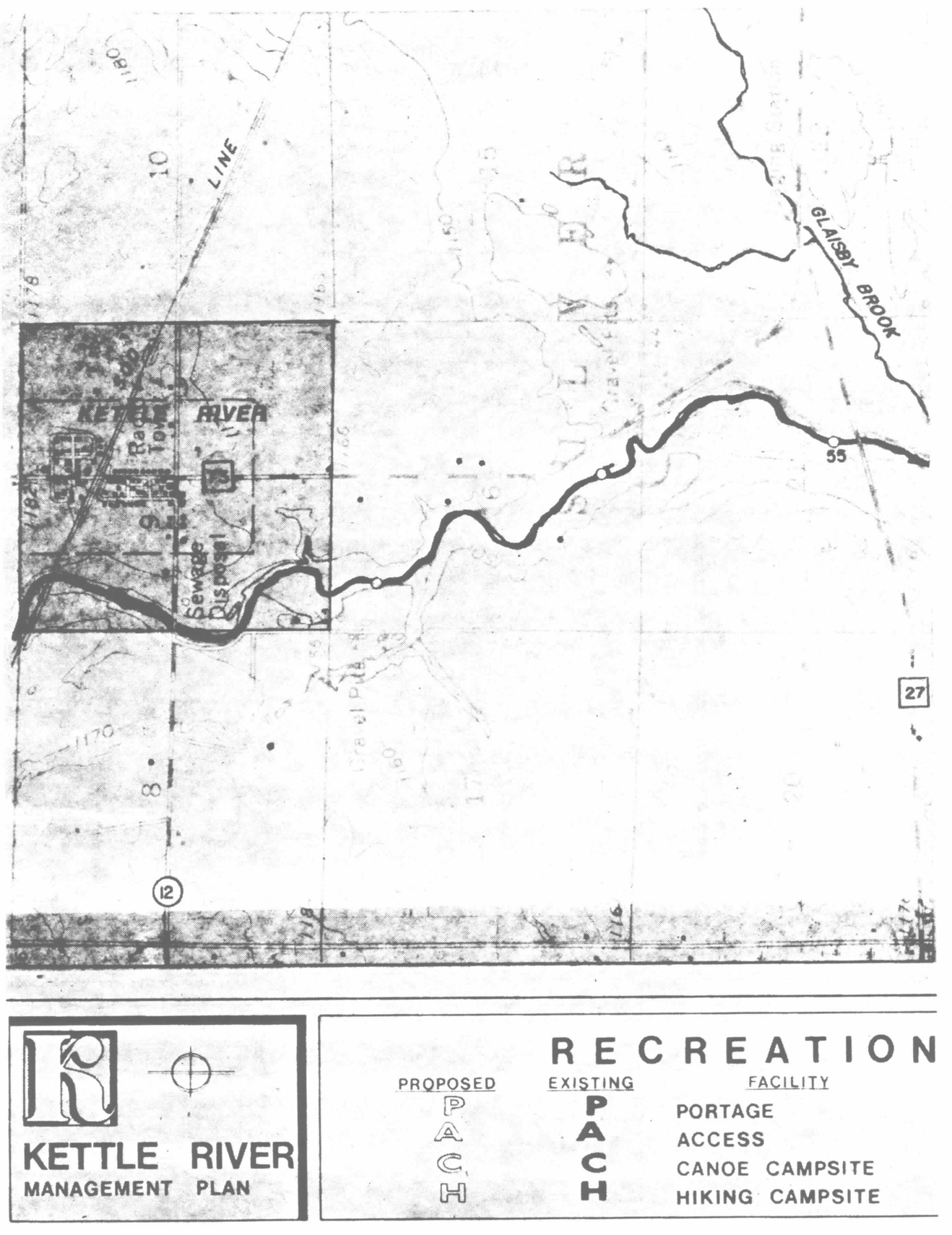
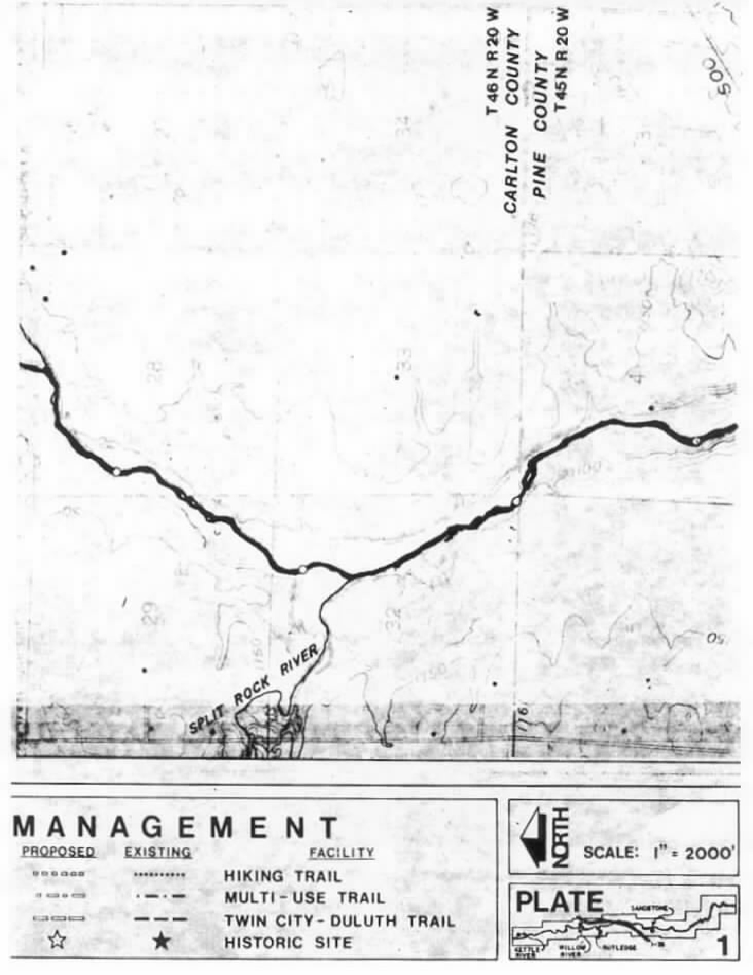
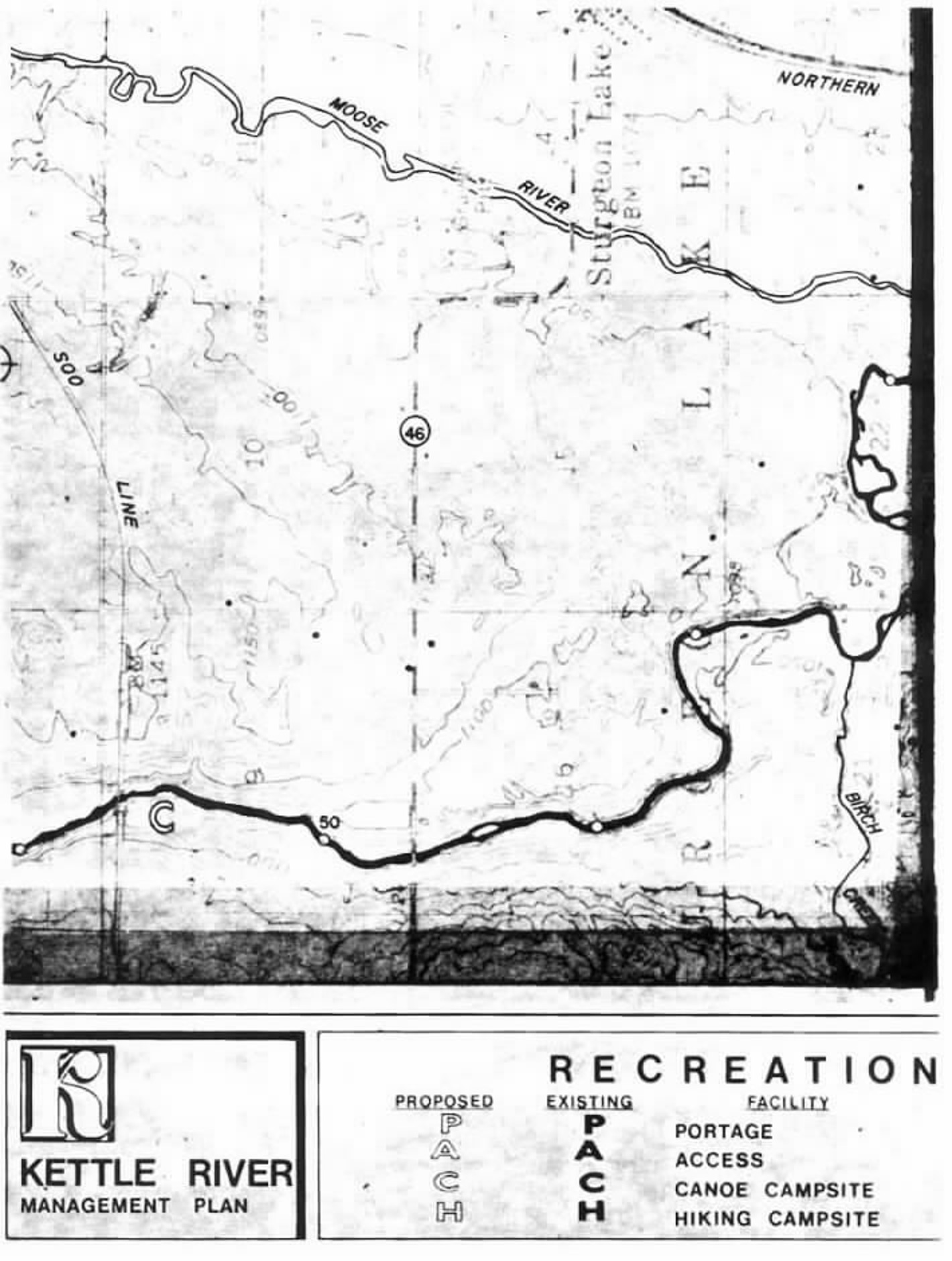
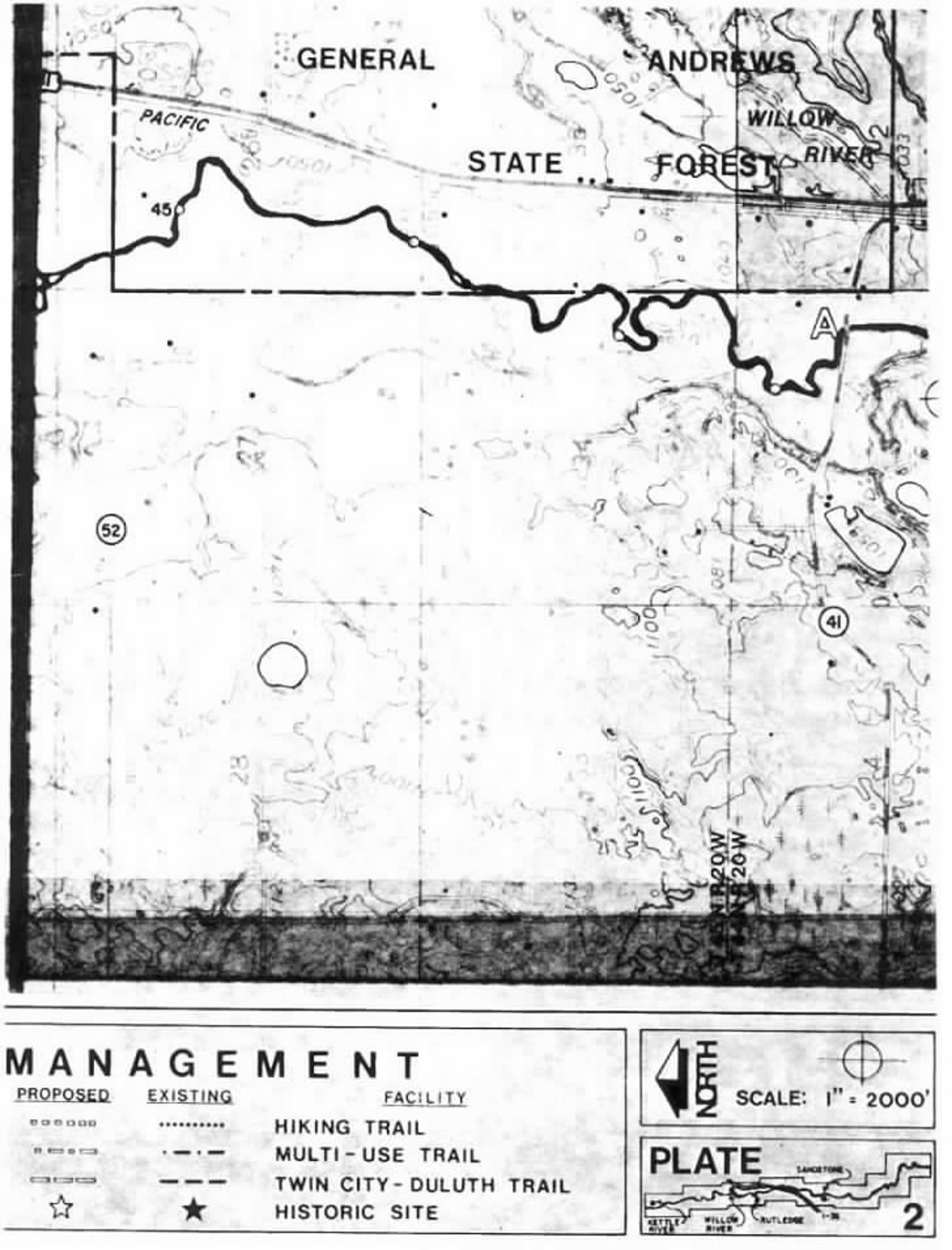
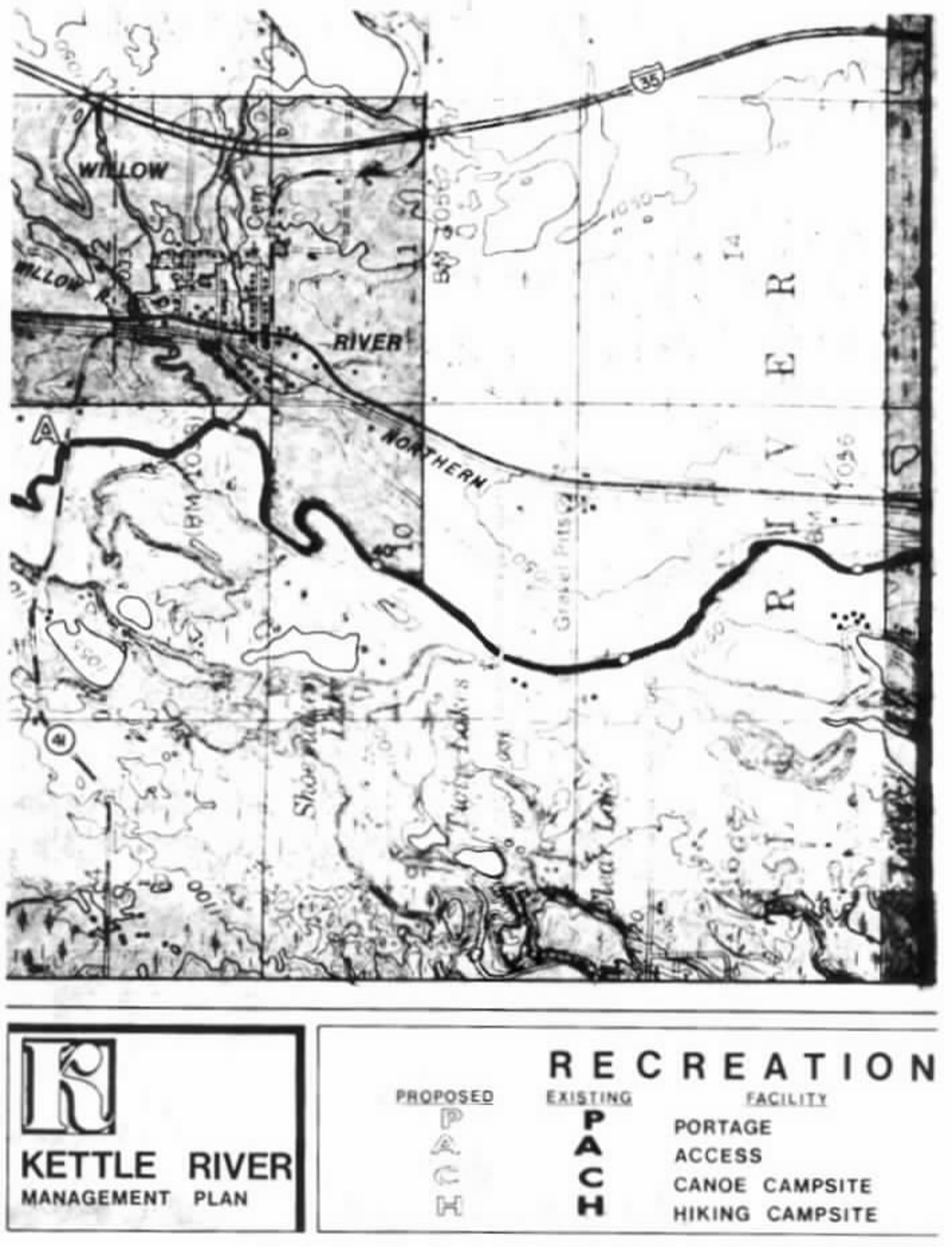
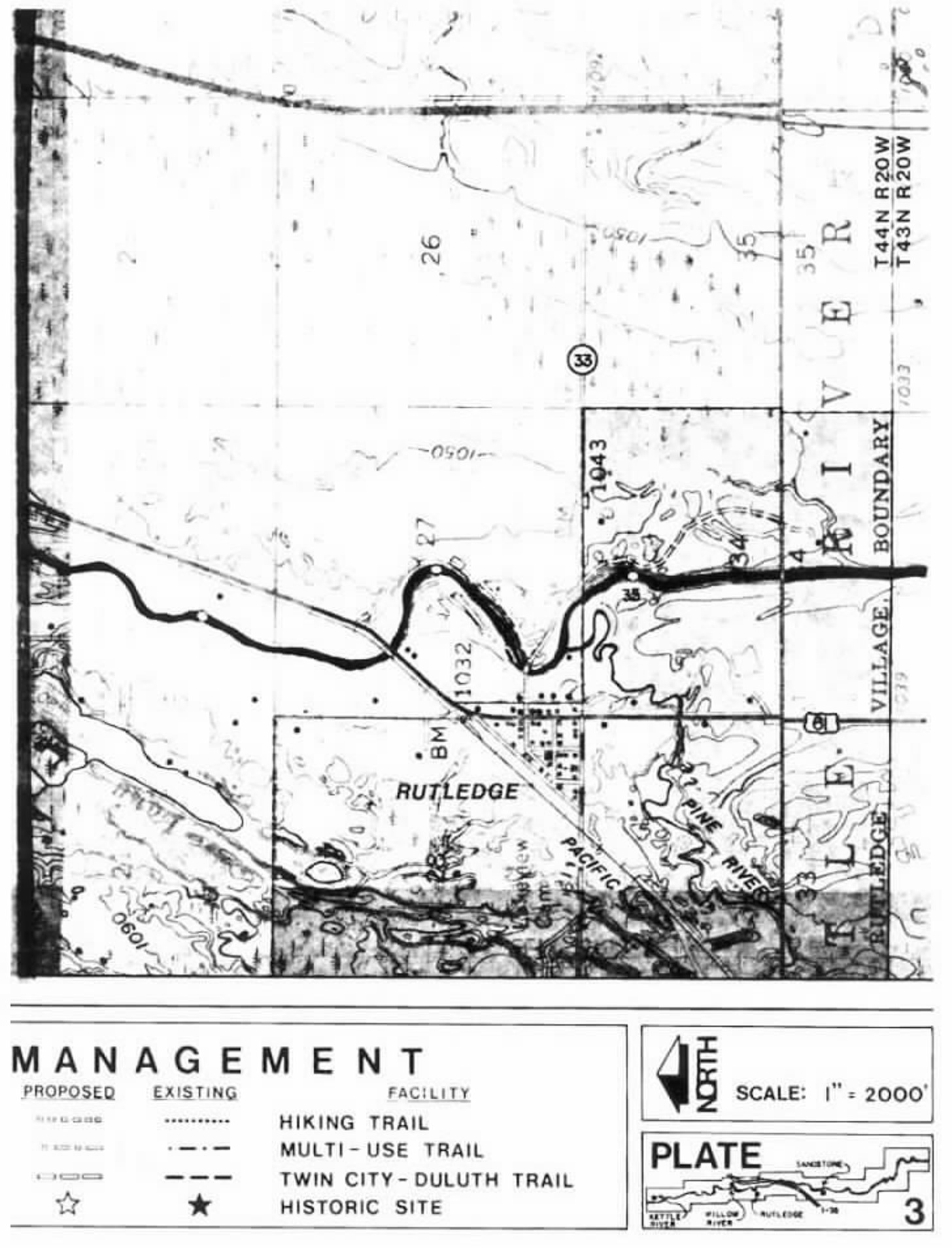
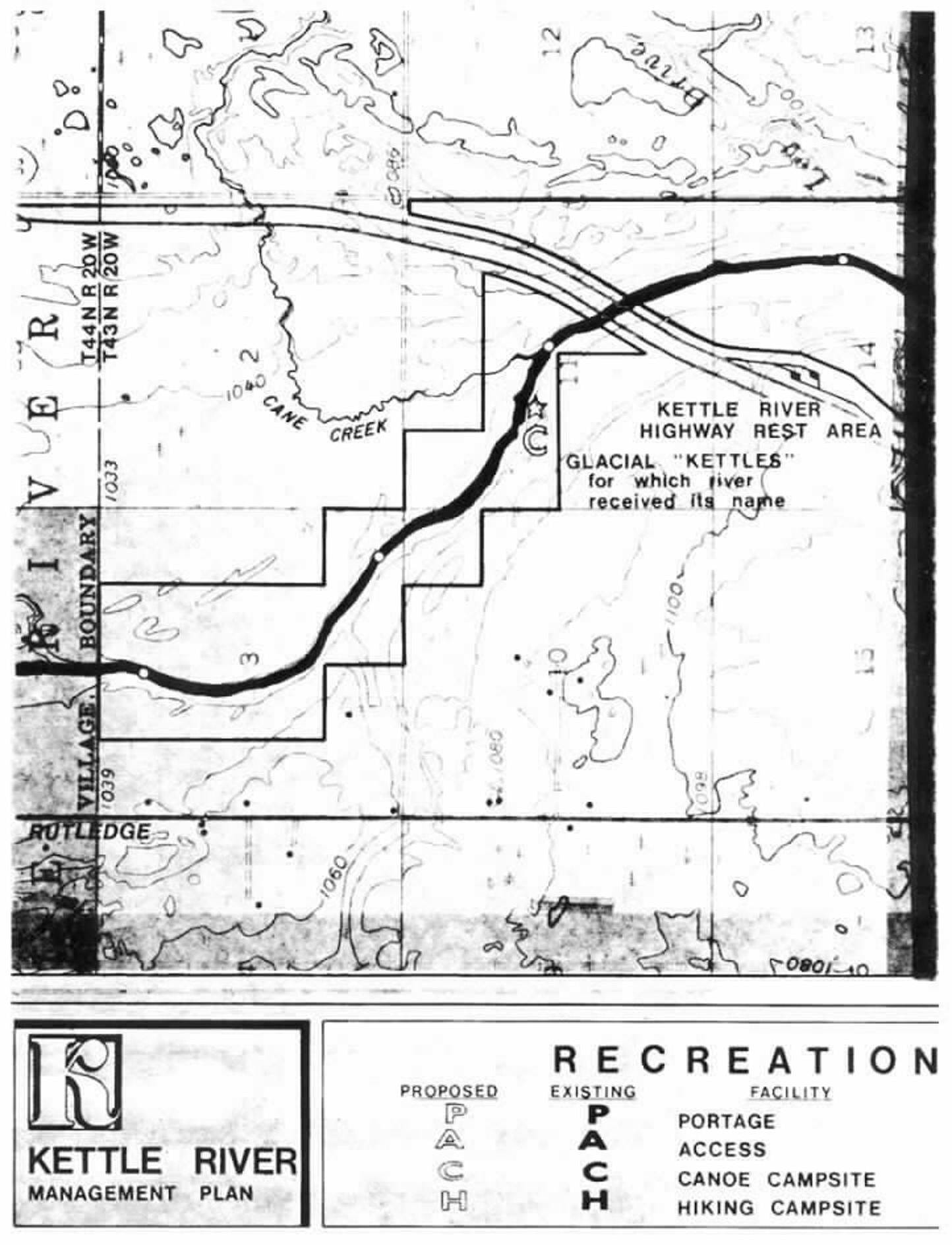
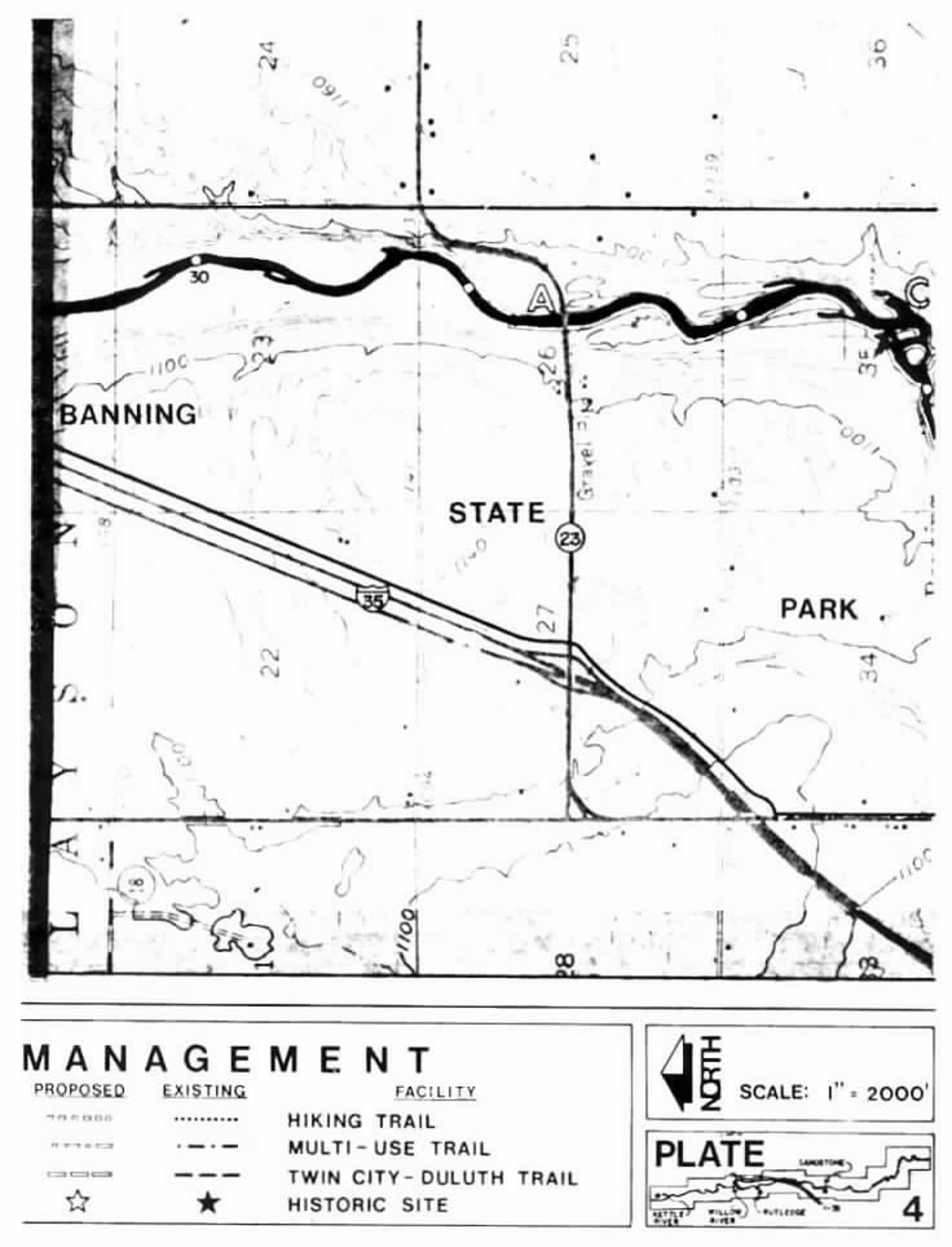
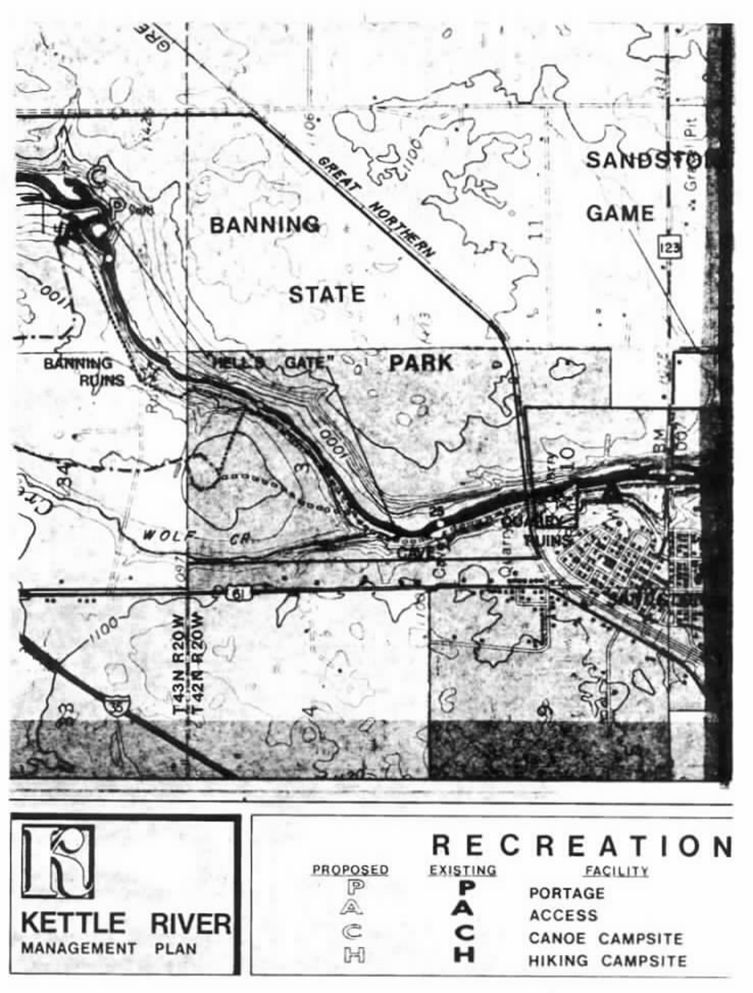
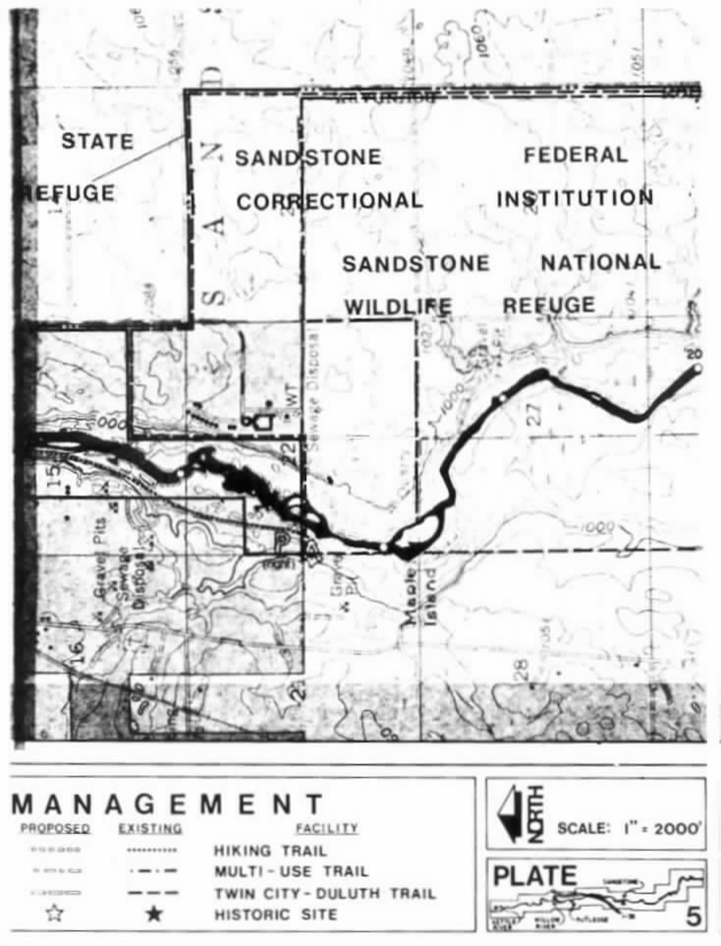
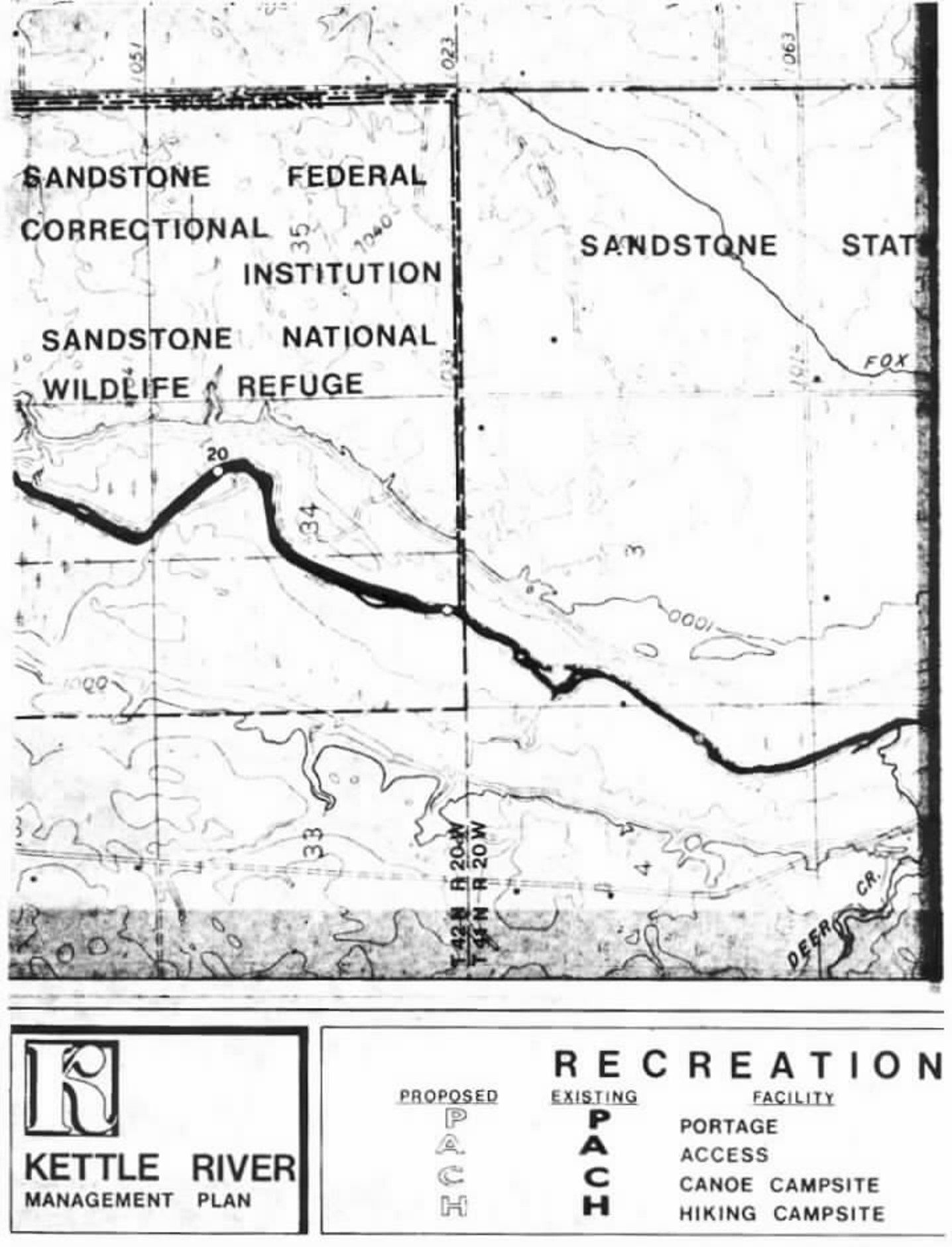
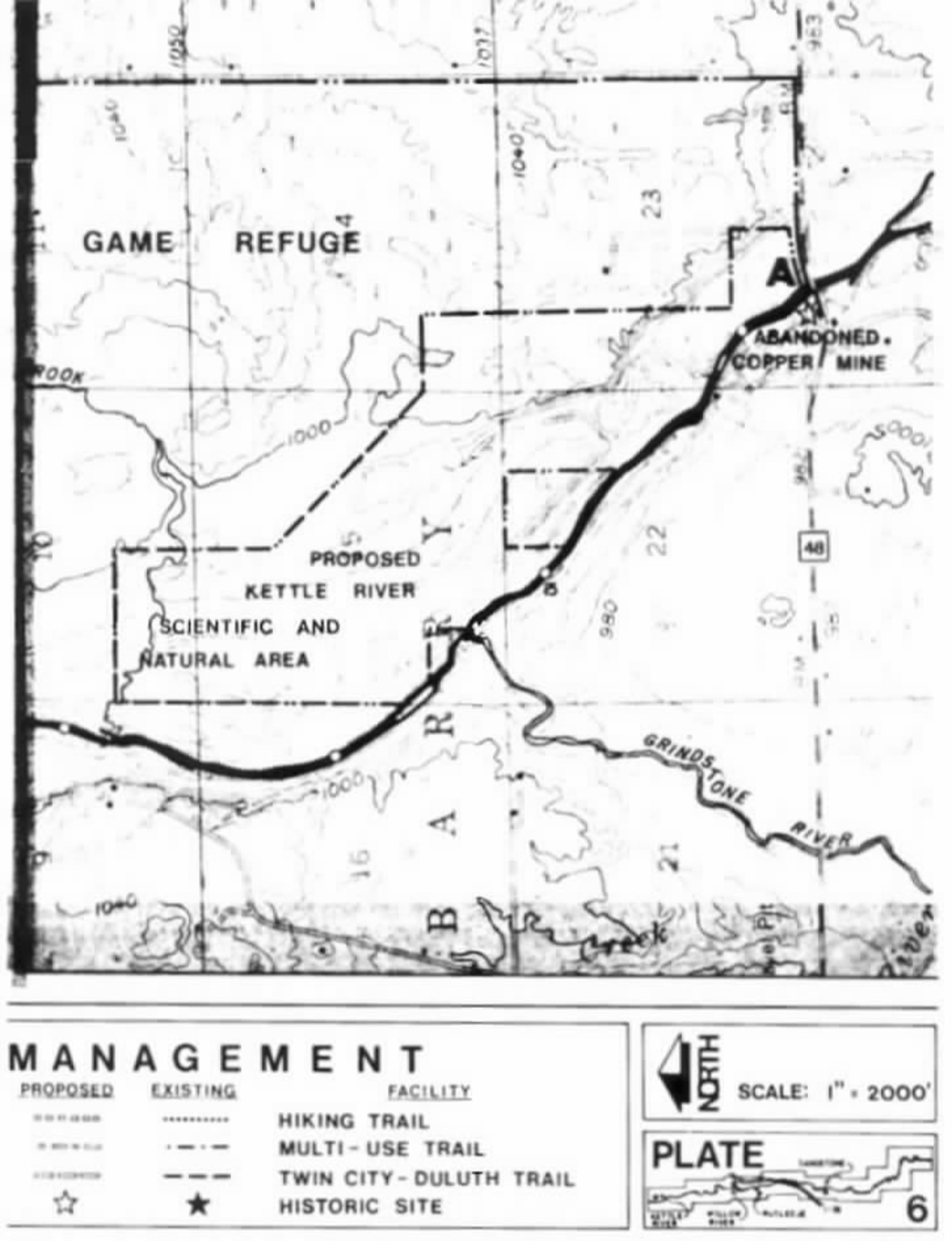
Statutory Authority:
MS s 104.35
Published Electronically:
June 11, 2008
6105.0720 PROPERTY DESCRIPTIONS AND ACREAGE.
| River Mile | Acreage |
| 0-1 | 106.74 |
| 1-2 | 263.77 |
| 2-3 | 300.20 |
| 3-4 | 316.02 |
| 4-5 | 319.50 |
| 5-6 | 288.05 |
| 6-7 | 301.56 |
| 7-8 | 320.00 |
| 8-9 | 300.00 |
| 9-10 | 320.00 |
| 10-11 | 310.00 |
| 11-12 | 268.45 |
| 12-13 | 320.00 |
| 13-14 | 319.00 |
| 14-15 | 317.00 |
| 15-16 | 320.00 |
| 16-17 | 300.00 |
| 17-18 | 310.00 |
| 18-19 | 309.89 |
| 19-20 | 310.00 |
| 20-21 | 310.00 |
| 21-22 | 310.00 |
| 22-23 | 296.00 |
| 23-24 | 265.00 |
| 24-25 | 271.50 |
| 25-26 | 280.00 |
| 26-27 | 318.71 |
| 27-28 | 286.36 |
| 28-29 | 316.44 |
| 29-30 | 258.89 |
| 30-31 | 242.11 |
| 31-32 | 305.23 |
| 32-33 | 316.66 |
| 33-34 | 299.36 |
| 34-35 | 295.49 |
| 35-36 | 265.81 |
| 36-37 | 294.59 |
| 37-38 | 226.81 |
| 38-39 | 301.62 |
| 39-40 | 311.81 |
| 40-41 | 289.22 |
| 41-42 | 285.66 |
| 42-43 | 244.46 |
| 43-44 | 303.37 |
| 44-45 | 317.65 |
| 45-46 | 311.78 |
| 46-47 | 319.11 |
| 47-48 | 310.95 |
| 48-49 | 316.95 |
| 49-50 | 318.27 |
| 50-51 | 289.20 |
| 51-52 | 299.74 |
| TOTAL - 15,298.93 |
Statutory Authority:
MS s 104.35
Published Electronically:
June 11, 2008
6105.0730 LAND USE DISTRICT ACREAGE.
Subpart 1.
T 45 N - R 20 W.
The land use district acreage for T 45 N - R 20 W is as follows:
| A. | Section 4 | Government Lot 3 | 45.34 acres |
| Government Lot 2 | 19.20 acres | ||
| Government Lot 10 | 31.96 acres | ||
| W 1/2 SWNE | 20.00 acres | ||
| Government Lot 9 | 34.54 acres | ||
| Government Lot 8 | 26.91 acres | ||
| Government Lot 7 | 47.50 acres | ||
| Government Lot 6 | 41.50 acres | ||
| Government Lot 5 | 42.75 acres | ||
| Government Lot 4 | 25.75 acres | ||
| B. | Section 5 | Government Lot 1 | 38.70 acres |
| C. | Section 9 | Government Lot 1 | 30.63 acres |
| Government Lot 2 | 16.98 acres | ||
| Government Lot 3 | 26.83 acres | ||
| Government Lot 4 | 44.12 acres | ||
| Government Lot 5 | 31.25 acres | ||
| Government Lot 6 | 48.75 acres | ||
| Government Lot 7 | 37.85 acres | ||
| Government Lot 8 | 23.75 acres | ||
| E 1/2 NWNW | 20.00 acres | ||
| W 1/2 SWNE | 20.00 acres | ||
| D. | Section 15 | W 1/2 W 1/2 SW | 40.00 acres |
| E. | Section 16 | W 1/2 NE | 80.00 acres |
| N 1/2 SE | 80.00 acres | ||
| Government Lot 1 | 32.50 acres | ||
| Government Lot 2 | 20.37 acres | ||
| Government Lot 3 | 20.93 acres | ||
| Government Lot 4 | 31.20 acres | ||
| Government Lot 5 | 19.95 acres | ||
| Government Lot 6 | 24.55 acres | ||
| Government Lot 7 | 35.50 acres | ||
| E 1/2 SWSW | 20.00 acres | ||
| Government Lot 8 | 35.50 acres | ||
| Government Lot 9 | 35.60 acres | ||
| Government Lot 10 | 40.75 acres | ||
| F. | Section 21 | Government Lot 1 | 5.50 acres |
| Government Lot 2 | 32.25 acres | ||
| W 1/2 NE | 80.00 acres | ||
| NENW | 40.00 acres | ||
| Government Lot 3 | 24.50 acres | ||
| Government Lot 4 | 13.10 acres | ||
| Government Lot 5 | 38.60 acres | ||
| NWSE | 40.00 acres | ||
| SESE | 40.00 acres | ||
| G. | Section 22 | W 1/2 NWNW | 20.00 acres |
| SWNW | 40.00 acres | ||
| Government Lot 12 | 36.56 acres | ||
| Government Lot 13 | 23.30 acres | ||
| Government Lot 2 | 9.35 acres | ||
| Government Lot 3 | 13.74 acres | ||
| Government Lot 4 | 4.10 acres | ||
| Government Lot 5 | 19.35 acres | ||
| Government Lot 6 | 17.25 acres | ||
| Government Lot 7 | 39.40 acres | ||
| Government Lot 8 | 39.90 acres | ||
| Government Lot 14 | 12.00 acres | ||
| Government Lot 9 | 34.25 acres | ||
| Government Lot 10 | 17.00 acres | ||
| Government Lot 11 | 22.00 acres | ||
| S 1/2 SW | 80.00 acres | ||
| SWSE | 40.00 acres | ||
| H. | Section 23 | Government Lot 5 | 28.59 acres |
| Government Lot 7 | 25.00 acres | ||
| SWSESW | 10.00 acres | ||
| Government Lot 8 | 9.61 acres | ||
| Government Lot 6 | 6.41 acres | ||
| I. | Section 26 | Government Lot 8 | 23.93 acres |
| SWNW | 40.00 acres | ||
| Government Lot 7 | 24.26 acres | ||
| Government Lot 1 | 51.65 acres | ||
| Government Lot 6 | 38.99 acres | ||
| Government Lot 3 | 38.34 acres | ||
| Government Lot 5 | 36.85 acres | ||
| W 1/2 NWNE | 17.50 acres | ||
| Government Lot 2 | 42.84 acres | ||
| W 1/2 NWNWSE | 3.75 acres | ||
| Government Lot 4 | 32.62 acres | ||
| J. | Section 27 | E 1/2 E 1/2 E 1/2 | 80.00 acres |
| K. | Section 34 | W 1/2 SE | 80.00 acres |
| SWNE | 40.00 acres | ||
| Government Lot 1 | 39.90 acres | ||
| Government Lot 2 | 28.50 acres | ||
| Government Lot 3 | 7.50 acres | ||
| Government Lot 4 | 27.54 acres | ||
| Government Lot 5 | 8.05 acres | ||
| Government Lot 6 | 30.44 acres | ||
| Government Lot 7 | 3.40 acres | ||
| L. | Section 35 | Government Lot 1 | 5.67 acres |
| Government Lot 2 | 31.25 acres | ||
| Government Lot 3 | 39.98 acres | ||
| Government Lot 4 | 0.17 acres | ||
| Government Lot 5 | 38.80 acres | ||
| Government Lot 6 | 39.69 acres | ||
| E 1/2 W 1/2 West of Road | 70.00 acres |
Subp. 2.
T 44 N - R 20 W.
The land use district acreage for T 44 N - R 20 W is as follows:
| A. | Section 2 | NWNW | 40.93 acres |
| SWNW | 40.00 acres | ||
| All west of road in W 1/2 SW | 25.00 acres | ||
| B. | Section 3 | Government Lot 3 | 47.34 acres |
| Government Lot 4 | 23.60 acres | ||
| Government Lot 5 | 34.03 acres | ||
| Government Lot 6 | 58.34 acres | ||
| SESW | 40.00 acres | ||
| Government Lot 7 | 57.05 acres | ||
| Government Lot 8 | 49.02 acres | ||
| Government Lot 9 | 25.73 acres | ||
| C. | Section 10 | W 1/2 NW | 80.00 acres |
| Government Lot 1 | 21.20 acres | ||
| NENE | 40.00 acres | ||
| Government Lot 2 | 41.06 acres | ||
| Government Lot 3 | 27.17 acres | ||
| Government Lot 4 | 50.13 acres | ||
| Government Lot 5 | 25.96 acres | ||
| Government Lot 6 | 47.44 acres | ||
| Government Lot 7 | 34.94 acres | ||
| Government Lot 8 | 52.24 acres | ||
| W 1/2 NWSE | 20.00 acres | ||
| D. | Section 15 | Government Lot 1 | 47.20 acres |
| Government Lot 2 | 23.70 acres | ||
| Government Lot 5 | 35.15 acres | ||
| Government Lot 6 | 11.00 acres | ||
| Government Lot 7 | 43.05 acres | ||
| Government Lot 8 | 49.53 acres | ||
| Government Lot 9 | 27.91 acres | ||
| W 1/2 NE West of road | 70.00 acres | ||
| Government Lot 3 | 26.69 acres | ||
| Government Lot 4 | 31.05 acres | ||
| W 1/2 NWSW East of Road | 22.00 acres | ||
| E. | Section 16 | E 1/2 E 1/2 NENE | 10.00 acres |
| F. | Section 22 | Government Lot 5 | 38.58 acres |
| Government Lot 6 | 50.52 acres | ||
| Government Lot 8 | 33.17 acres | ||
| Government Lot 9 | 40.66 acres | ||
| Government Lot 1 | 26.25 acres | ||
| Government Lot 2 | 21.25 acres | ||
| Government Lot 3 | 21.85 acres | ||
| Government Lot 4 | 26.72 acres | ||
| G. | Section 27 | W 1/2 E 1/2 | 160.00 acres |
| Government Lot 1 | 47.23 acres | ||
| Government Lot 2 | 34.43 acres | ||
| Government Lot 3 | 27.83 acres | ||
| Government Lot 4 | 49.06 acres | ||
| Government Lot 5 | 24.62 acres | ||
| Government Lot 6 | 47.06 acres | ||
| Government Lot 7 | 39.68 acres | ||
| Government Lot 8 | 27.95 acres | ||
| H. | Section 34 | Government Lot 1 | 48.63 acres |
| Government Lot 2 | 48.54 acres | ||
| Government Lot 3 | 43.93 acres | ||
| Government Lot 4 | 40.75 acres | ||
| Government Lot 5 | 32.34 acres | ||
| Government Lot 6 | 30.33 acres | ||
| Government Lot 7 | 26.38 acres | ||
| Government Lot 8 | 25.86 acres |
Subp. 3.
T 43 N - R 20 W.
The land use district acreage for T 43 N - R 20 W is as follows:
| A. | Section 2 | W 1/2 SWSW | 20.00 acres |
| B. | Section 3 | Government Lot 2 | 43.58 acres |
| Government Lot 3 | 49.35 acres | ||
| Government Lot 4 | 38.56 acres | ||
| Government Lot 5 | 36.68 acres | ||
| NESE | 40.00 acres | ||
| Government Lot 6 | 38.73 acres | ||
| E 1/2 SESW | 20.00 acres | ||
| Government Lot 7 | 33.35 acres | ||
| Government Lot 8 | 25.06 acres | ||
| Government Lot 9 | 28.36 acres | ||
| C. | Section 10 | Government Lot 2 | 33.61 acres |
| Government Lot 1 | 1.75 acres | ||
| E 1/2 NWNE | 20.00 acres | ||
| SENE | 40.00 acres | ||
| D. | Section 11 | Government Lot 1 | 37.63 acres |
| NENW | 40.00 acres | ||
| Government Lot 2 | 21.40 acres | ||
| Government Lot 3 | 34.36 acres | ||
| Government Lot 4 | 25.24 acres | ||
| Government Lot 5 | 38.57 acres | ||
| Government Lot 6 | 34.85 acres | ||
| Government Lot 7 | 20.08 acres | ||
| Government Lot 8 | 46.75 acres | ||
| E 1/2 SESW | 20.00 acres | ||
| NESW | 40.00 acres | ||
| E. | Section 14 | Government Lot 1 | 32.55 acres |
| Government Lot 2 | 35.87 acres | ||
| Government Lot 3 | 54.86 acres | ||
| Government Lot 4 | 57.25 acres | ||
| Government Lot 5 | 37.06 acres | ||
| Government Lot 6 | 38.66 acres | ||
| Government Lot 7 | 42.23 acres | ||
| F. | Section 23 | Government Lot 1 | 38.98 acres |
| Government Lot 2 | 38.40 acres | ||
| Government Lot 3 | 45.36 acres | ||
| Government Lot 4 | 28.56 acres | ||
| Government Lot 5 | 45.00 acres | ||
| Government Lot 6 | 28.45 acres | ||
| Government Lot 7 | 35.42 acres | ||
| Government Lot 8 | 33.96 acres | ||
| G. | Section 26 | Government Lot 1 | 35.40 acres |
| Government Lot 2 | 66.54 acres | ||
| Government Lot 3 | 31.55 acres | ||
| Government Lot 4 | 35.97 acres | ||
| Government Lot 5 | 40.10 acres | ||
| Government Lot 6 | 54.86 acres | ||
| E 1/2 E 1/2 W 1/2 | 80.00 acres | ||
| H. | Section 34 | Government Lot 2 | 29.43 acres |
| NESE | 40.00 acres | ||
| Government Lot 1 | 6.30 acres | ||
| I. | Section 35 | Government Lot 1 | 34.94 acres |
| Government Lot 2 | 31.56 acres | ||
| Government Lot 3 | 29.06 acres | ||
| Government Lot 4 | 56.15 acres | ||
| Government Lot 5 | 39.07 acres | ||
| Government Lot 6 | 35.25 acres | ||
| Government Lot 7 | 23.24 acres | ||
| Government Lot 8 | 42.28 acres | ||
| E 1/2 NENW | 20.00 acres | ||
| S 1/2 NW | 80.00 acres | ||
| SWSE | 40.00 acres | ||
| W 1/2 NESE | 20.00 acres |
Subp. 4.
T 42 N - R 20 W.
The land use district acreage for T 42 N - R 20 W is as follows:
| A. | Section 3 | NENE | 43.74 acres |
| NWNE | 43.77 acres | ||
| S 1/2 NE | 80.00 acres | ||
| N 1/2 SE | 80.00 acres | ||
| E 1/2 SW | 80.00 acres | ||
| E 1/2 W 1/2 SW | 40.00 acres | ||
| B. | Section 10 | E 1/2 NW | 80.00 acres |
| E 1/2 E 1/2 W 1/2 NW | 20.00 acres | ||
| SWNE | 40.00 acres | ||
| W 1/2 SE | 80.00 acres | ||
| NWNESW | 9.00 acres | ||
| E 1/2 E 1/2 SW | 32.50 acres | ||
| C. | Section 15 | W 1/2 E 1/2 | 160.00 acres |
| E 1/2 SW | 80.00 acres | ||
| E 1/2 SWSW | 20.00 acres | ||
| SENW | 40.00 acres | ||
| E 1/2 E 1/2 NENW | 10.00 acres | ||
| D. | Section 21 | E 1/2 NESE | 20.00 acres |
| SESE | 40.00 acres | ||
| E. | Section 22 | NW | 160.00 acres |
| W 1/2 SW | 80.00 acres | ||
| W 1/2 E 1/2 SW | 40.00 acres | ||
| NENESW | 10.00 acres | ||
| W 1/2 NWNE | 20.00 acres | ||
| F. | Section 27 | NW | 160.00 acres |
| E 1/2 NESW | 20.00 acres | ||
| E 1/2 SESW | 20.00 acres | ||
| W 1/2 SE | 80.00 acres | ||
| W 1/2 E 1/2 E 1/2 SE | 20.00 acres | ||
| SWNE | 40.00 acres | ||
| W 1/2 NWNE | 20.00 acres | ||
| SENWNE | 10.00 acres | ||
| SWNENE | 10.00 acres | ||
| W 1/2 SENE | 20.00 acres | ||
| W 1/2 SENENE | 5.00 acres | ||
| W 1/2 E 1/2 SENE | 10.00 acres | ||
| W 1/2 E 1/2 SE | 40.00 acres | ||
| G. | Section 28 | NENE | 40.00 acres |
| H. | Section 34 | NE | 160.00 acres |
| E 1/2 NENW | 20.00 acres | ||
| E 1/2 SENW | 20.00 acres | ||
| E 1/2 SW | 80.00 acres | ||
| NWSE | 40.00 acres | ||
| N 1/2 SWSE | 20.00 acres | ||
| SWSWSE | 10.00 acres | ||
| NWNESE | 10.00 acres | ||
| W 1/2 SWNESE | 5.00 acres | ||
| SENWSW | 10.00 acres | ||
| SWSENW | 10.00 acres | ||
| E 1/2 SWSW | 20.00 acres |
Subp. 5.
T 42 N - R 20 W.
The land use district acreage for T 41 N - R 20 W is as follows:
| A. | Section 3 | N 1/2 NW | 111.59 acres |
| SWNW | 40.00 acres | ||
| W 1/2 SENW | 20.00 acres | ||
| W 1/2 W 1/2 SW | 40.00 acres | ||
| NENWSW | 10.00 acres | ||
| B. | Section 4 | E 1/2 NENE | 28.30 acres |
| SENE | 40.00 acres | ||
| E 1/2 SE | 80.00 acres | ||
| E 1/2 W 1/2 SE | 40.00 acres | ||
| C. | Section 9 | E 1/2 E 1/2 | 160.00 acres |
| E 1/2 W 1/2 E 1/2 East of road | 60.00 acres | ||
| D. | Section 10 | W 1/2 W 1/2 W 1/2 | 80.00 acres |
| E 1/2 NWSW | 20.00 acres | ||
| SESWNW | 10.00 acres | ||
| E. | Section 15 | W 1/2 W 1/2 NW | 40.00 acres |
| W 1/2 SW | 80.00 acres | ||
| SESW | 40.00 acres | ||
| W 1/2 NWSW | 20.00 acres | ||
| W 1/2 SWSE | 20.00 acres | ||
| F. | Section 16 | E 1/2 E 1/2 | 160.00 acres |
| E 1/2 W 1/2 NE | 40.00 acres | ||
| E 1/2 W 1/2 W 1/2 NE | 20.00 acres | ||
| G. | Section 22 | NWSENW | 10.00 acres |
| N 1/2 NW | 80.00 acres | ||
| E 1/2 SENW | 20.00 acres | ||
| S 1/2 NE | 80.00 acres | ||
| W 1/2 NWNE | 20.00 acres | ||
| SENWNE | 10.00 acres | ||
| NESE | 40.00 acres | ||
| NENWSE | 10.00 acres | ||
| NESESE | 10.00 acres | ||
| H. | Section 23 | S 1/2 SW | 80.00 acres |
| S 1/2 N 1/2 SW | 40.00 acres | ||
| N 1/2 NWSW | 20.00 acres | ||
| NWNESW | 10.00 acres | ||
| S 1/2 SWNW | 20.00 acres | ||
| I. | Section 26 | NWNWNW North of road | 6.00 acres |
| W 1/2 E 1/2 | 160.00 acres | ||
| E 1/2 W 1/2 | 160.00 acres | ||
| E 1/2 NWNW | 20.00 acres | ||
| W 1/2 SENE | 20.00 acres | ||
| E 1/2 SWSW | 20.00 acres | ||
| J. | Section 35 | W 1/2 E 1/2 | 160.00 acres |
| W 1/2 SESE | 20.00 acres | ||
| E 1/2 W 1/2 | 160.00 acres | ||
| E 1/2 NWNW | 20.00 acres |
Subp. 6.
T 40 N - R 20 W.
The land use district acreage for T 40 N - R 20 W is as follows:
| A. | Section 3 | SWSW | 40.00 acres |
| NWSW | 34.49 acres | ||
| B. | Section 4 | SESE | 40.00 acres |
| NESE | 33.96 acres | ||
| C. | Section 9 | NENE | 40.00 acres |
| D. | Section 10 | NW | 160.00 acres |
| E 1/2 SW | 80.00 acres | ||
| SWNE | 40.00 acres | ||
| SWNWNE | 10.00 acres | ||
| W 1/2 SE | 80.00 acres | ||
| W 1/2 SESE | 20.00 acres | ||
| E. | Section 13 | S 1/2 S 1/2 | 160.00 acres |
| F. | Section 14 | SW | 160.00 acres |
| S 1/2 SE | 80.00 acres | ||
| NWSE | 40.00 acres | ||
| S 1/2 NESE | 20.00 acres | ||
| SWNW | 40.00 acres | ||
| S 1/2 NWNW | 20.00 acres | ||
| S 1/2 SENW | 20.00 acres | ||
| G. | Section 15 | E 1/2 NE | 80.00 acres |
| NWNE | 40.00 acres | ||
| E 1/2 SWNE | 20.00 acres | ||
| E 1/2 NENW | 20.00 acres | ||
| E 1/2 NESE | 20.00 acres | ||
| H. | Section 23 | NENE | 40.00 acres |
| E 1/2 NWNE | 20.00 acres | ||
| I. | Section 24 | N 1/2 N 1/2 | 160.00 acres |
| N 1/2 S 1/2 NE | 40.00 acres |
Subp. 7.
T 40 N - R 19 W.
The land use district acreage for T 40 N - R 19 W is as follows:
| A. | Section 18 | S 1/2 SWSW | 19.56 acres |
| B. | Section 19 | Government Lot 1 | 12.40 acres |
| Government Lot 2 | 28.20 acres | ||
| Government Lot 3 | 49.80 acres | ||
| Government Lot 4 | 38.20 acres | ||
| Government Lot 5 | 15.80 acres | ||
| Government Lot 6 | 33.60 acres | ||
| Government Lot 7 | 56.70 acres | ||
| Government Lot 8 | 20.00 acres | ||
| Government Lot 9 | 37.90 acres | ||
| Government Lot 10 | 35.50 acres | ||
| C. | Section 20 | Government Lot 1 | 37.50 acres |
| W 1/2 NWSW | 20.00 acres | ||
| D. | Section 29 | Government Lot 7 | 18.90 acres |
| Government Lot 6 | 45.50 acres | ||
| W 1/2 NENW | 20.00 acres | ||
| Government Lot 5 | 47.50 acres | ||
| Government Lot 4 | 21.84 acres | ||
| SWSE | 40.00 acres | ||
| Government Lot 3 | 48.60 acres | ||
| Government Lot 2 | 22.65 acres | ||
| Government Lot 1 | 9.40 acres | ||
| E. | Section 30 | E 1/2 NE | 80.00 acres |
| E 1/2 E 1/2 SE | 40.00 acres | ||
| F. | Section 32 | N 1/2 NWNW | 20.00 acres |
| Government Lot 9 | 24.90 acres | ||
| Government Lot 8 | 19.60 acres | ||
| Government Lot 6 | 33.70 acres | ||
| Government Lot 7 | 34.66 acres | ||
| Government Lot 5 | 21.30 acres | ||
| Government Lot 4 | 60.80 acres | ||
| Government Lot 3 | 49.60 acres | ||
| Government Lot 2 | 53.40 acres | ||
| Government Lot 1 | 45.55 acres | ||
| G. | Section 33 | Government Lot 1 | 5.20 acres |
| Government Lot 2 | 29.80 acres | ||
| S 1/2 NWSW | 20.00 acres |
Subp. 8.
T 39 N - R 19 W.
The land use district acreage for T 39 N - R 19 W is as follows:
| A. | Section 4 | Government Lot 7 | 16.00 acres |
| Government Lot 9 | 30.30 acres | ||
| Government Lot 10 | 35.60 acres | ||
| Government Lot 11 | 38.87 acres | ||
| Government Lot 8 | 13.40 acres | ||
| B. | Section 5 | Government Lot 1 | 36.54 acres |
| Government Lot 2 | 35.78 acres | ||
| SENE | 40.00 acres | ||
| NENE | 34.55 acres | ||
| NWNE | 34.85 acres | ||
| NENW | 35.15 acres | ||
| C. | Section 8 | Government Lot 7 | 26.64 acres |
| Government Lot 1 | 9.40 acres | ||
| Government Lot 6 | 30.70 acres | ||
| D. | Section 9 | NWNW | 40.00 acres |
Statutory Authority:
MS s 104.35
Published Electronically:
June 11, 2008
6105.0740 SCENIC EASEMENT ACREAGE.
Subpart 1.
T 45 N - R 20 W.
The scenic easement acreage for T 45 N - R 20 W is as follows:
| A. | Section 4 | Government Lot 3 | 45.34 acres |
| Government Lot 10 | 31.96 acres | ||
| Government Lot 9 | 34.50 acres | ||
| Government Lot 8 | 26.91 acres | ||
| B. | Section 9 | Government Lot 1 | 30.63 acres |
| Government Lot 2 | 16.98 acres | ||
| Government Lot 3 | 26.83 acres | ||
| W 1/2 SWNE | 20.00 acres | ||
| Government Lot 4 | 44.12 acres | ||
| Government Lot 5 | 31.25 acres | ||
| C. | Section 15 | W 1/2 SWSW | 20.00 acres |
| D. | Section 16 | Government Lot 4 | 31.20 acres |
| Government Lot 5 | 19.95 acres | ||
| Government Lot 3 | 20.93 acres | ||
| E. | Section 21 | N 1/2 NWNE | 20.00 acres |
| N 1/2 NENW | 20.00 acres | ||
| Government Lot 1 | 5.50 acres | ||
| Government Lot 2 | 16.13 acres | ||
| F. | Section 22 | W 1/2 NWNW | 20.00 acres |
| Government Lot 2 | 19.35 acres | ||
| Government Lot 5 | 19.35 acres | ||
| G. | Section 23 | Government Lot 5 | 28.59 acres |
| Government Lot 7 | 25.00 acres | ||
| Government Lot 6 | 6.41 acres | ||
| H. | Section 26 | Government Lot 1 | 39.15 acres |
| Government Lot 3 | 18.34 acres | ||
| Government Lot 4 | 19.62 acres |
Subp. 2.
T 44 N - R 20 W.
The scenic easement acreage for T 44 N - R 20 W is as follows:
| A. | Section 2 | SWNWSWNW | 2.50 acres |
| W 1/2 SWSWNW | 5.00 acres | ||
| B. | Section 3 | Government Lot 3 | 47.34 acres |
| Government Lot 4 | 10.00 acres | ||
| Government Lot 5 | 34.03 acres | ||
| C. | Section 10 | Government Lot 1 | 21.20 acres |
| NENE | 40.00 acres | ||
| Government Lot 2 | 20.53 acres | ||
| Government Lot 3 | 27.17 acres | ||
| Government Lot 6 | 47.44 acres | ||
| Government Lot 7 | 34.94 acres | ||
| Government Lot 8 | 32.24 acres | ||
| W 1/2 NWSE | 20.00 acres | ||
| D. | Section 27 | Government Lot 2 | 34.43 acres |
| E. | Section 34 | Government Lot 2 | 28.54 acres |
| Government Lot 3 | 23.93 acres | ||
| Government Lot 4 | 20.75 acres |
Subp. 3.
T 41 N - R 20 W.
The scenic easement acreage for T 41 N - R 20 W is as follows:
| A. | Section 9 | E 1/2 E 1/2 West of river | 144.00 acres |
| E 1/2 W 1/2 E 1/2 | 65.00 acres | ||
| B. | Section 15 | S 1/2 SESW | 20.00 acres |
| C. | Section 16 | NESE West of river | 34.00 acres |
| W 1/2 W 1/2 NE | 40.00 acres | ||
| E 1/2 SESE | 20.00 acres | ||
| D. | Section 22 | N 1/2 NW | 80.00 acres |
| N 1/2 SENW | 20.00 acres | ||
| SESENW | 10.00 acres | ||
| S 1/2 NE | 80.00 acres | ||
| W 1/2 NWNE | 20.00 acres | ||
| SENWNE | 10.00 acres | ||
| NESE | 40.00 acres | ||
| NESESE | 10.00 acres | ||
| E. | Section 23 | W 1/2 W 1/2 SW | 40.00 acres |
| SWSWNW | 10.00 acres | ||
| E 1/2 SWSW West of river | 13.00 acres | ||
| F. | Section 26 | E 1/2 NWNW | 20.00 acres |
| E 1/2 SESW East of river | 13.00 acres | ||
| SWSESW East of river | 3.00 acres | ||
| NWNWNW North of road | 3.50 acres | ||
| W 1/2 NENW West of river | 16.00 acres | ||
| SENW | 40.00 acres | ||
| G. | Section 35 | W 1/2 W 1/2 E 1/2 NE | 40.00 acres |
| N 1/2 NENW East of river | 10.00 acres | ||
| E 1/2 SWSE | 20.00 acres | ||
| SENWSE | 10.00 acres |
Subp. 4.
T 40 N - R 20 W.
The scenic easement acreage for T 40 N - R 20 W is as follows:
| A. | Section 3 | N 1/2 NWSW | 25.86 acres |
| SWNWSW | 10.00 acres | ||
| B. | Section 4 | SESE | 40.00 acres |
| C. | Section 9 | S 1/2 NENE | 20.00 acres |
| NWNENE | 10.00 acres | ||
| D. | Section 10 | NWNW South of river | 21.00 acres |
| NESWNW | 10.00 acres | ||
| E 1/2 NESW West of river | 17.00 acres | ||
| N 1/2 SENW West of river | 15.00 acres | ||
| SESENW | 9.00 acres |
Subp. 5.
Total.
The total scenic easement acreage for this part is 2,117.44 acres; this equals 13.84 percent of the land use district.
Statutory Authority:
MS s 104.35
Published Electronically:
June 11, 2008
6105.0750 ACQUISITION ACREAGE.
Subpart 1.
T 44 N - R 20 W.
The acquisition acreage for T 44 N - R 20 W is as follows:
| Section 3 | Government Lot 4 | 13.60 acres |
Subp. 2.
T 43 N - R 20 W.
The acquisition acreage for T 43 N - R 20 W is as follows:
| A. | Section 3 | Government Lot 2 | 37.58 acres |
| Government Lot 3 | 43.35 acres | ||
| Government Lot 4 | 32.56 acres | ||
| Government Lot 5 | 30.68 acres | ||
| Government Lot 6 | 32.73 acres | ||
| Government Lot 7 | 27.35 acres | ||
| Government Lot 8 | 19.06 acres | ||
| Government Lot 9 | 22.36 acres | ||
| B. | Section 11 | Government Lot 1 | 37.63 acres |
| Government Lot 3 | 34.36 acres | ||
| Government Lot 7 | 20.08 acres | ||
| Government Lot 2 | 5.00 acres | ||
| C. | Section 34 | Government Lot 2 | 12.00 acres |
| NESE | 40.00 acres |
Subp. 3.
T 42 N - R 20 W.
The acquisition acreage for T 42 N - R 20 W is as follows:
| A. | Section 3 | NENWSW | 10.00 acres |
| E 1/2 SWSW | 20.00 acres | ||
| S 1/2 NE | 80.00 acres | ||
| N 1/2 SE | 80.00 acres | ||
| SESW | 40.00 acres | ||
| B. | Section 10 | E 1/2 E 1/2 W 1/2 NW | 20.00 acres |
| E 1/2 W 1/2 E 1/2 W 1/2 NW | 10.00 acres | ||
| W 1/2 SE | 80.00 acres | ||
| NWNESW | 9.00 acres | ||
| S 1/2 SWNE south of railroad | 17.00 acres | ||
| S 1/2 SENW south of railroad | 13.00 acres | ||
| C. | Section 15 | NWNE | 40.00 acres |
| NESW | 40.00 acres | ||
| SENW | 40.00 acres | ||
| D. | Section 22 | NWNW | 40.00 acres |
Subp. 4.
T 41 N - R 20 W.
The acquisition acreage for T 41 N - R 20 W is as follows:
| Section 23 | SWSESW | 10.00 acres |
Subp. 5.
T 40 N - R 20 W.
The acquisition acreage for T 40 N - R 20 W is as follows:
| Section 9 | NENENE | 10.00 acres |
Subp. 6.
T 40 N - R 19 W.
The acquisition acreage for T 40 N - R 19 W is as follows:
| Section 33 | Government Lot 2 | 29.80 acres | |
| S 1/2 NWSW | 20.00 acres |
Subp. 7.
T 39 N - R 19.
The acquisition acreage for T 39 N - R 19 W is as follows:
| A. | Section 4 | Government Lot 7 | 16.00 acres |
| Government Lot 9 | 30.30 acres | ||
| Government Lot 10 | 35.60 acres | ||
| Government Lot 11 | 38.87 acres | ||
| Government Lot 8 | 13.40 acres | ||
| B. | Section 5 | Government Lot 1 | 36.54 acres |
| Government Lot 2 | 35.78 acres | ||
| SENE | 40.00 acres | ||
| NENE | 34.55 acres | ||
| NWNE | 34.85 acres | ||
| NENW | 35.15 acres | ||
| C. | Section 8 | Government Lot 7 | 26.64 acres |
| Government Lot 1 | 9.40 acres | ||
| Government Lot 6 | 30.70 acres |
Subp. 8.
Total.
The total acquisition acreage for this part is 1,342.92 acres; this equals 8.78 percent of the land use district.
Statutory Authority:
MS s 104.35
Published Electronically:
June 11, 2008
6105.0760 TYPICAL TRAIL DESIGN.
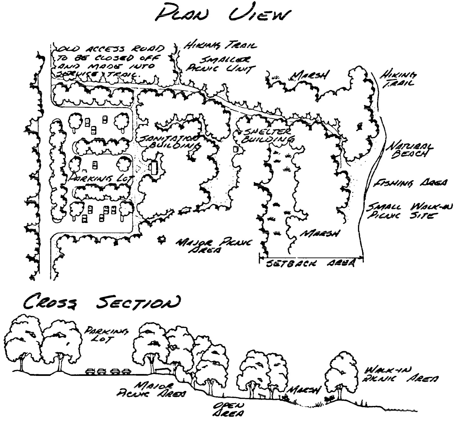
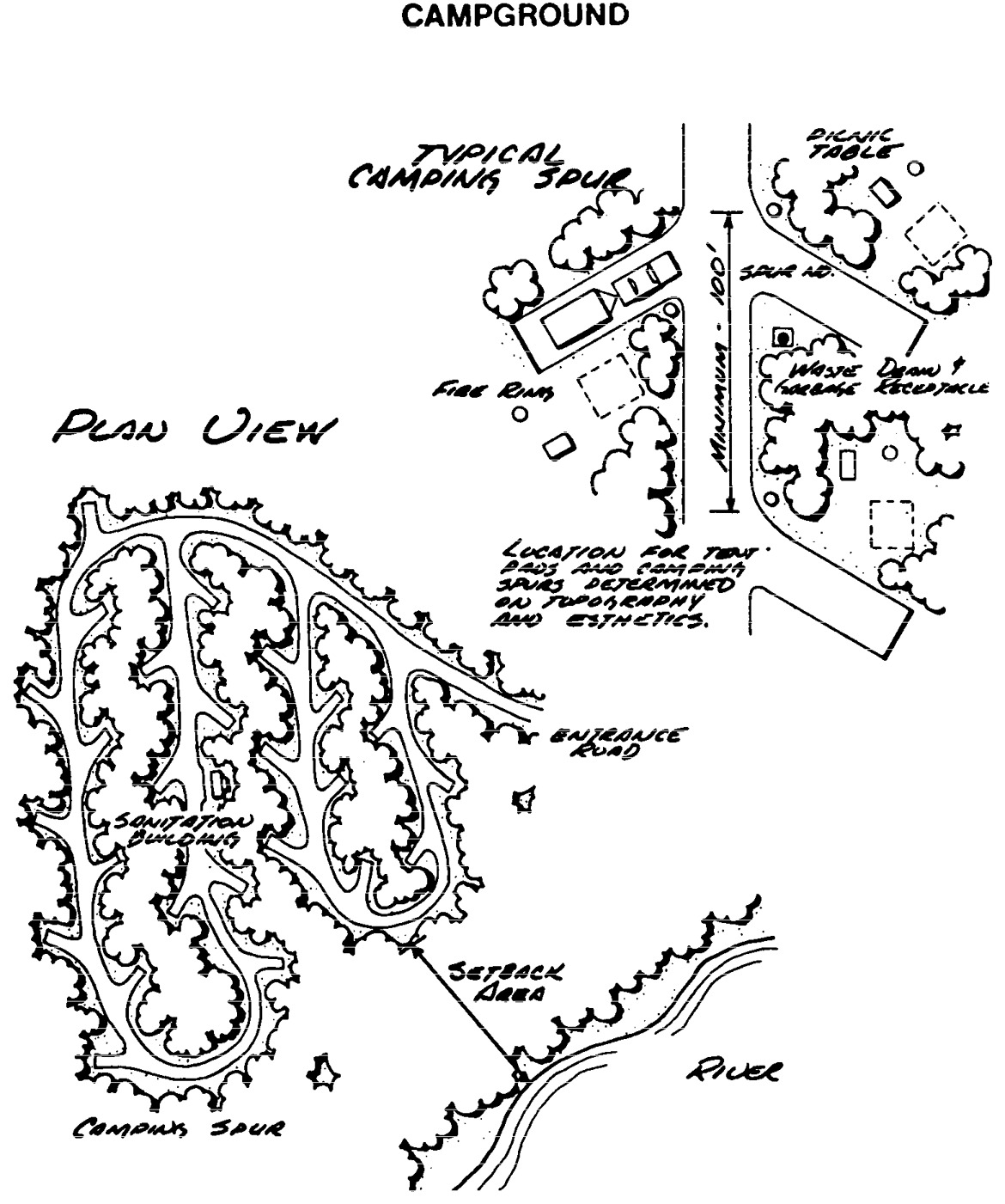
Statutory Authority:
MS s 104.35
Published Electronically:
June 11, 2008
MISSISSIPPI RIVER MANAGEMENT PLAN
6105.0800 DESIGNATION OF RIVER.
That portion of the Mississippi River from the County State-Aid Highway No. 7 bridge at Saint Cloud to the northwestern boundaries of the city of Anoka and the city of Champlin is hereby designated a component of the Minnesota wild, scenic, and recreational rivers system.
Statutory Authority:
MS s 104.35
Published Electronically:
June 11, 2008
6105.0810 STATUTORY AUTHORITY.
This designation is made by the commissioner of natural resources pursuant to the authority of the Minnesota Wild and Scenic Rivers Act, Minnesota Statutes, sections 103F.301 to 103F.345.
Published Electronically:
June 11, 2008
6105.0820 SCOPE.
The designation and parts 6105.0800 to 6105.0960 apply to the river and the adjacent lands as provided in the land management maps in part 6105.0950, plates 1 to 9 and the property descriptions for the land use districts.
Statutory Authority:
MS s 104.35
Published Electronically:
June 11, 2008
6105.0830 CLASSIFICATION: SCENIC RIVER.
That portion of the Mississippi River and adjacent lands from the County State-Aid Highway No. 7 bridge at Saint Cloud to the county line at the Clearwater River between Stearns and Wright Counties, and State Highway No. 24 in Sherburne County, is classified as scenic.
Statutory Authority:
MS s 104.35
Published Electronically:
June 11, 2008
6105.0840 CLASSIFICATION: RECREATIONAL.
That portion of the designated river and adjacent lands from the county line at the Clearwater River between Stearns and Wright Counties, and State Highway No. 24 in Sherburne County, to the northwestern boundaries of the city of Anoka and the city of Champlin is classified as recreational, in accordance with the provision of Minnesota Statutes, sections 103F.311, subdivision 4, and 103F.315, subdivision 2, and part 6105.0060.
Published Electronically:
June 11, 2008
6105.0850 RECREATION MANAGEMENT.
Subpart 1.
Policy.
As provided for in the management plan, the recreation management policy is to provide for the orderly use of public lands and waters within the scenic and recreational river land use district. The development of selected land and river-oriented recreational facilities and the maintenance of these will help protect the rights of private landowners, ensure quietude, prohibit trespassing, and maintain the essential quality of wild and scenic river land use districts as provided in part 6105.0210, subpart 1.
Subp. 2.
Design specifications.
As provided for in part 6105.0100, subpart 3 and the management plan, the development of public or private recreational facilities within the scenic and recreational river land use districts shall conform to the design specification guidelines as shown on figures 1 to 6 in part 6105.0940.
Subp. 3.
Camping.
No public river-oriented camping facilities will be provided in close proximity to private recreational developments which are designed to serve the public demand for these.
Subp. 4.
Regulated use.
The recreational use of the Mississippi Scenic and Recreational River and adjacent public lands will be regulated where necessary to ensure that the use does not adversely affect the values for which the river qualified for designation.
Subp. 5.
Management maps.
The commissioner of natural resources adopts the recreation management maps, plates 1 to 9 in part 6105.0960, for the protection, recreational use, and management of public lands or interests in land, for the Mississippi Scenic and Recreational River and its adjacent lands within the recreational river land use districts.
Subp. 6.
Funds.
The Division of Parks and Recreation shall allocate funds for maintenance of the Department of Natural Resources' recreational facilities within the Mississippi River land use districts from the department's river development and maintenance account.
Subp. 7.
Division of responsibilities.
The department's Enforcement Division shall enter into discussions with the local units of government concerning delineation of responsibility for enforcement of applicable wild, scenic, and recreational river regulations.
Subp. 8.
Islands.
All islands acquired by or transferred to the Department of Natural Resources, shall be managed in a manner consistent with the policy established in the Minnesota Wild and Scenic Rivers Act, Minnesota Statutes 1974, sections 104.31 to 104.40.
Subp. 9.
Wildlife studies.
Wildlife studies will be completed, if possible, in cooperation with local groups and individuals before permanently siting any Department of Natural Resources recreational facilities within the Mississippi Scenic and Recreational River area.
Subp. 10.
Volunteers.
The assistance of volunteer groups will be encouraged to help in the removal of litter from Department of Natural Resources water access campsites and rest areas.
Statutory Authority:
MS s 104.35
Published Electronically:
June 11, 2008
6105.0860 LAND MANAGEMENT.
Subpart 1.
Tributaries.
The designated tributaries referred to in parts 6105.0110, subpart 3, item B, subitem (3) and 6105.0120 shall be:
Subp. 2.
Management maps.
The commissioner of natural resources hereby adopts the land management maps, plates 1 to 9 in part 6105.0950 to the area identified in the legal description and according to part 6105.0070, subpart 2, item B for the protection and management of lands within the scenic and recreational river land use districts.
A.
Parts 6105.0010 to 6105.0250 shall apply to all lands within the scenic and recreational river land use districts that are within unincorporated areas of the counties at the time of designations. Federal lands, however, are not subject to these parts.
B.
The land or interests in land recommended to be acquired in this plan will be acquired where funds are available for such purchases, in the manner as provided for in Minnesota Statutes 1974, section 104.37.
C.
Portions of the scenic or recreational land use districts which are within the boundaries of municipalities on the date of designation shall be covered by various provisions of parts 6105.0010 to 6105.0250 and parts 6120.2600 to 6120.3900, as specified in part 6105.0870, subparts 5 to 9.
D.
Because acquisition of land, or interests in land, is from willing sellers, at the appraised value, some lands recommended for scenic easement acquisition may be purchased in fee title. This change from the recommended acquisition would be based on the mutual agreement by and between the state of Minnesota and the landowner(s). Furthermore, additional lands, or interests in land, may be purchased in order to further the policies established in Minnesota Statutes, section 103F.305, and this management plan.
E.
Land exchanges will be expedited, wherever feasible, in order to acquire lands within the land use district boundaries. These exchanges will be expedited in the manner described by law. However, land exchanges will not be recommended if such exchanges would adversely affect other Department of Natural Resources management programs.
Published Electronically:
June 11, 2008
6105.0870 ADMINISTRATION OF MANAGEMENT PLAN.
Subpart 1.
Scope.
The land use controls referenced herein shall apply to the entire area within the land use district boundaries as identified on the land management maps, plates 1 to 9 in part 6105.0950, and the land use district property descriptions and determined in accordance with part 6105.0070, subpart 2, item B. In accordance with the Minnesota wild and scenic rivers act, Minnesota Statutes 1974, section 104.36 each local government shall, within six months of designation of the scenic and recreational river, adopt or amend its local ordinances and land use district maps to the extent necessary to comply with the statewide standards and criteria and the management plan as follows.
Subp. 2.
Stearns County.
Stearns County shall enact or amend such ordinances and maps as necessary to:
Subp. 3.
Sherburne County.
Sherburne County shall enact or amend such ordinances and maps as necessary to:
Subp. 4.
Wright County.
Wright County shall enact or amend such ordinances and maps as necessary to:
Subp. 5.
Saint Cloud.
The municipality of Saint Cloud shall enact or amend such ordinances and maps as necessary to:
A.
establish a scenic river land use district as identified on the land management maps, plate 1 in part 6105.0950, subpart 1, and the land use district property descriptions;
Subp. 6.
Clearwater, Monticello, and Elk River.
The municipalities of Clearwater, Monticello, and Elk River shall enact or amend such ordinances and maps as necessary to:
A.
establish a recreational river land use district as identified on the land management maps, plates 1 to 9 in part 6105.0950 and the land use district property descriptions;
Subp. 7.
Becker, Dayton, and Ramsey.
The municipalities of Becker, Dayton, and Ramsey shall enact or amend such ordinances and maps as necessary to:
A.
establish a recreational river land use district as identified on the land management maps, plates 1 to 9 in part 6105.0950, and the land use district property descriptions; and
B.
conform to the provisions of parts 6105.0010 to 6105.0250, except that the lot size requirements of part 6120.3300, subpart 2, item A, for natural environment waters under the statewide standards and criteria for the management of municipal shoreland areas of Minnesota shall be substituted for the lot size requirements of part 6105.0110, subpart 2, item A, subitem (3).
Subp. 8.
Elk River Township.
Elk River Township, excluding the presently incorporated city of Elk River, shall be subject to parts 6105.0010 to 6105.0250 until such time as it may be consolidated and incorporated. At that time those regulations required for the city of Elk River (see subpart 6) will apply to the newly incorporated area as well. In addition, the minimum setback for any new structure shall be 100 feet rather than 75 feet.
Subp. 9.
Power plants.
The Northern States Power Company Sherco and Monticello power plant sites shall be listed in the Sherburne and Wright county ordinances as permitted uses. Northern States Power Company shall work with the Department of Natural Resources in determining the most appropriate location for the development of any structures or related facilities that may be located within the scenic and recreational land use district boundary. Such development shall be consistent with all other provisions of parts 6105.0080 to 6105.0200.
Subp. 10.
Land in annexation area.
The portion of the land use district which is within the orderly annexation area established by the Minnesota Municipal Board adjacent to the city of Monticello in 1972 legally described in the land use district as Government Lots 1, 2, 3 and 4 of Section 18 and Government Lots 1, 2 and 3 of Section 8, Township 121 N. Range 24 W. of Wright County, shall be governed by the recreational development standards of parts 6120.2600 to 6120.3900. The zoning authority shall also conform to the provisions of parts 6105.0010 to 6105.0070; and 6105.0150 to 6105.0250.
Subp. 11.
Otsego.
The municipality of Otsego shall enact or amend such ordinances and maps as necessary to:
A.
establish a recreational river land use district, as identified on the land management maps, plates 1 to 9 in part 6105.0950, and the land use district property descriptions;
B.
for the recreational river land use district within Sections 10, 11, 13, 14, and 15, Township 121 North, Range 24 West and Sections 7 and 18, Township 121 North, Range 23 West, conform to the provisions of parts 6105.0010 to 6105.0250, except that minimum lot size shall be 2-1/2 acres; and
C.
for the recreational river land use district west of State Highway 101 within Sections 14, 23, 26 and Government Lot 1 and the East 1/2 of the East 1/2 of the Southeast 1/4 of Section 15, Township 121 North, Range 23 West and for the recreational river land use district west of CSAH 42 in Section 26, Township 121 North, Range 23 West, conform to the provisions and administrative procedures of parts 6105.0010 to 6105.0090; 6105.0100, subparts 1 and 2; Urban river class standards in parts 6120.3100, 6120.3200, and 6120.3300, subpart 2b; 6120.3300, subparts 7 to 12; 6120.3800; and 6105.0110 to 6105.0250 with the following exceptions to the provisions of these parts:
(5)
impervious surface coverage requirements in part 6120.3300, subpart 11, item B, may be varied without a variance if all of the following criteria and standards are met:
(a)
all structures and impervious surfaces are located on slopes less than 13 percent. The physical alteration of slopes shall not be permitted for the purpose of overcoming this limitation;
(b)
the site development is designed, implemented, and maintained using the most applicable combination of comprehensive practices that prevent flooding, pollution, erosion, and sedimentation problems consistent with "Protecting Water Quality in Urban Areas, Best Management Practices for Minnesota," Minnesota Pollution Control Agency, October 1989, which is incorporated by reference, is available at the State Law Library, and is not subject to frequent change;
(c)
a site development, maintenance, and inspection plan incorporating the comprehensive practices in unit (b) is approved by the local government and implemented; and
D.
for the recreational river land use district within Sections 10, 14, 15, 16, 17, 23, 25, 26, and 36, Township 121 North, Range 23 West that is not listed in item C, conform to the provisions and administrative procedures listed in item C, except minimum lot size shall be 2-1/2 acres and maximum total lot area covered by impervious surface shall be 25 percent and not subject to variability.
History:
18 SR 1751
Published Electronically:
October 8, 2013
6105.0880 INTERAGENCY RECOMMENDATIONS.
Subpart 1.
Federal and state relations.
As authorized under Minnesota Statutes 1974, section 161.142, subdivision 4 the commissioner of transportation "...may act as agent for any other department of state, public corporation, or political subdivision of the state in accepting federal aid in their behalf for the purposes expressed in subdivisions 1 to 7." This relates to the planning, acquisition, development, maintenance, and overall administration of the Great River Road. Accordingly, it is recommended that a portion of any federal funds made available to the state of Minnesota for expenditure on the Great River Road be accepted by the commissioner of transportation, on behalf of the Department of Natural Resources, for the purposes of land acquisition related to preservation of areas adjacent to the designated recreational river and the Great River Road.
It is further recommended that any proposed development, acquisition or related action concerning the Great River Road be conducted and administered in accordance with this management plan and the provisions of parts 6105.0010 to 6105.0250.
Since the Department of Natural Resources is responsible for administering the Mississippi as a scenic and recreational river, it is recommended that the state of Minnesota, through the appropriate application process, apply for those islands presently administered by the Bureau of Land Management to be transferred to the Department of Natural Resources under the authority granted the commissioner of natural resources in Minnesota Statutes 1974, section 104.35.
The Department of Natural Resources is presently working in cooperation with the Bureau of Outdoor Recreation, U.S. Department of Interior, on their study of the Mississippi River from Itasca to Anoka for possible inclusion in the national wild and scenic rivers system. This study area includes that portion of the river from Saint Cloud to Anoka hereby designated as a state scenic and recreational river. If the entire federal study area is recommended for inclusion in the national wild and scenic rivers system it is recommended that the portion from Saint Cloud to Anoka continue to be administered by the Department of Natural Resources.
Subp. 2.
Other governmental units.
Other governmental units:
A.
In order to further the purposes of the Minnesota Wild and Scenic Rivers Act, it is recommended that all Department of Transportation lands within the recreational river land use districts be administered in accordance with the provisions of parts 6105.0010 to 6105.0250 and this management plan. In particular, it is stated in part 6105.0100, subpart 3, item C that public accesses within the recreational river land use district will be subject to management plan specifications and will be considered as permitted uses. Also, part 6105.0200, subpart 7 states that highway waysides shall be designed in such a manner so as to harmonize with the surroundings.
B.
No Department of Natural Resources corridor trails are proposed in this management plan for the Mississippi scenic or recreational river area. Local residents and landowners may desire specific recreational trails for their area. If so, it is recommended that such trails be developed through the Department of Natural Resources' trail assistance programs. Through the department's trail assistance programs, funds for local trail development and maintenance are made available to local units of government.
C.
It is recommended that the Minnesota Department of Transportation, in cooperation with the Department of Natural Resources, Governor's Trail Advisory Committee, counties, municipalities, and other agencies and groups, conduct a study to determine an appropriate route for a bicycle route paralleling the Mississippi River from the Twin Cities to Saint Cloud.
D.
To help ensure that the outstanding heritage of the Mississippi River will be protected for future generations, it is recommended that the Minnesota Historical Society conduct an inventory of all historical and archaeological sites within the proposed scenic and recreational river land use districts, and recommend appropriate methods for preservation of those having outstanding historical significance.
E.
It is recommended that the Minnesota Pollution Control Agency be appropriated sufficient funds to conduct ongoing analysis and monitoring of water quality information, and to allow for appropriate measures to ensure that water quality regulations and standards be maintained for the Mississippi River.
F.
It is recommended that Stearns County and the city of Saint Cloud work with local groups and the Department of Natural Resources to determine the best site for location of an access to the river below the Saint Cloud Dam.
Statutory Authority:
MS s 104.35
Published Electronically:
June 11, 2008
6105.0900 LAND MANAGEMENT TOTALS.
Subpart 1.
Land use district acreages.
Land use district acreages are as follows:
B.
West Bank:
| Stearns County | 1,537.33 | ||
| Wright County | 4,714.03 | ||
| Hennepin County | 964.25 | ||
| _ | |||
| Total | 7,215.61 | ||
| _ | |||
| Grand Total | 14,949.72 |
History:
13 SR 38
Published Electronically:
June 11, 2008
6105.0910 LAND USE DISTRICT ACREAGES.
Subpart 1.
T 35 N - R 31 W.
The land use district acreages for T 35 N - R 31 W in Sherburne County are as follows:
| A. | Section 1 | |
| Government Lot 4 | 17.00 acres West of Road | |
| B. | Section 12 | |
| Government Lot 1 | 30.00 acres West of Road | |
| Government Lot 2 | 37.20 acres West of Road | |
| Government Lot 3 | 41.20 acres West of Road | |
| Government Lot 4 | 23.50 acres West of Road | |
| Government Lot 5 | 4.73 acres Island | |
| Government Lot 6 | 15.34 acres Island | |
| Government Lot 7 | 7.45 acres Island | |
| Government Lot 8 | 14.88 acres Island | |
| Government Lot 9 | 44.95 acres Island | |
| C. | Section 13 | |
| Government Lot 1 | 2.60 acres Island | |
| Government Lot 2 | 1.80 acres Island | |
| Government Lot 3 | 19.33 acres Island | |
| Government Lot 4 | 49.00 acres West | |
| Government Lot 5 | 57.10 acres | |
| Government Lot 6 | 48.30 acres | |
| Government Lot 7 | 23.47 acres West | |
| D. | Section 24 | |
| Government Lot 1 | 53.60 acres | |
| Government Lot 2 | 74.82 acres | |
| Government Lot 3 | 72.85 acres | |
| Government Lot 4 | 54.50 acres West | |
| E. | Section 25 | |
| Government Lot 1 | 51.38 acres West | |
| Government Lot 2 | 59.85 acres West | |
| Government Lot 3 | 64.57 acres West |
Subp. 2.
T 35 N - R 30 W.
The land use district acreages for T 35 N - R 30 W in Sherburne County are as follows:
| A. | Section 30 | |
| NW 1/4 SW 1/4 | 44.24 acres | |
| Government Lot 1 | 43.24 acres | |
| B. | Section 31 | |
| Government Lot 3 | 67.00 acres | |
| Government Lot 2 | 23.74 acres South | |
| Government Lot 1 | 59.55 acres | |
| C. | Section 32 | |
| Government Lot 1 | 66.58 acres West of Road | |
| SW 1/4 SE 1/4 | 3.00 acres West of Road | |
| NW 1/4 SW 1/4 | 40.00 acres |
Subp. 3.
T 34 N - R 30 W.
The land use district acreages for T 34 N - R 30 W in Sherburne County are as follows:
| A. | Section 5 | |
| Government Lot 1 | 32.29 acres | |
| NW 1/4 NE 1/4 | 19.00 acres West of Road | |
| Government Lot 2 | 45.10 acres West of Road | |
| Government Lot 3 | 41.42 acres | |
| Government Lot 4 | 44.00 acres | |
| B. | Section 8 | |
| Government Lot 1 | 72.60 acres | |
| Government Lot 2 | 61.60 acres | |
| Government Lot 3 | 9.39 acres Island | |
| C. | Section 9 | |
| Government Lot 1 | 42.75 acres South | |
| Government Lot 2 | 38.40 acres | |
| Government Lot 3 | 50.30 acres | |
| D. | Section 14 | |
| S 1/2 SW 1/4 SW 1/4 | 20.00 acres | |
| E. | Section 15 | |
| Government Lot 1 | 2.52 acres | |
| Government Lot 2 | 48.55 acres South | |
| SE 1/4 NW 1/4 | 40.00 acres | |
| Government Lot 3 | 40.20 acres | |
| Government Lot 4 | 38.60 acres | |
| Government Lot 5 | 39.90 acres | |
| Government Lot 6 | 30.85 acres | |
| F. | Section 16 | |
| Government Lot 1 | 43.00 acres | |
| Government Lot 2 | 38.70 acres | |
| G. | Section 22 | |
| Government Lot 1 | 11.00 acres | |
| H. | Section 23 | |
| NW 1/4 NW 1/4 | 40.00 acres | |
| Government Lot 1 | 33.24 acres | |
| Government Lot 2 | 44.30 acres | |
| Government Lot 3 | 47.80 acres | |
| I. | Section 25 | |
| Government Lot 1 | 61.68 acres | |
| Government Lot 2 | 78.50 acres | |
| Government Lot 3 | 31.00 acres South Part | |
| Government Lot 4 | 19.70 acres South Part | |
| J. | Section 26 | |
| Government Lot 1 | 50.20 acres | |
| K. | Section 36 | |
| Government Lot 1 | 54.00 acres |
Subp. 4.
T 34 N - R 29 W.
The land use district acreages for T 34 N - R 29 W in Sherburne County are as follows:
| A. | Section 30 | |
| Government Lot 1 | 24.05 acres West | |
| Government Lot 2 | 26.84 acres | |
| Government Lot 3 | 24.00 acres | |
| Government Lot 4 | 30.57 acres | |
| Government Lot 5 | 34.50 acres | |
| B. | Section 31 | |
| Government Lot 2 | 8.38 acres | |
| Government Lot 1 | .77 acres | |
| C. | Section 32 | |
| Government Lot 1 | 44.25 acres | |
| Government Lot 2 | 58.00 acres | |
| Government Lot 3 | 45.80 acres | |
| Government Lot 4 | 35.10 acres | |
| D. | Section 33 | |
| S 1/2 SW 1/4 SE 1/4 | 20.00 acres | |
| Government Lot 1 | 36.95 acres | |
| E. | Section 34 | |
| Government Lot 1 | 39.70 acres | |
| SE 1/4 SW 1/4 | 40.00 acres | |
| Government Lot 2 | 31.90 acres | |
| Government Lot 3 | 25.95 acres | |
| F. | Section 35 | |
| Government Lot 1 | 37.75 acres |
Subp. 5.
T 33 N - R 29 W.
The land use district acreages for T 33 N - R 29 W in Sherburne County are as follows:
| A. | Section 2 | |
| Government Lot 1 | 10.64 acres Island | |
| Government Lot 2 | 21.90 acres | |
| Government Lot 3 | 31.75 acres | |
| Government Lot 4 | 17.00 acres West | |
| Government Lot 5 | 25.55 acres West | |
| Government Lot 6 | 56.20 acres | |
| B. | Section 3 | |
| Government Lot 1 | 18.34 acres | |
| C. | Section 4 | |
| Government Lot 4 | 34.25 acres | |
| Government Lot 3 | 51.32 acres | |
| NE 1/4 NW 1/4 | 35.40 acres | |
| Government Lot 2 | 19.91 acres | |
| Government Lot 1 | 33.38 acres | |
| D. | Section 5 | |
| Government Lot 1 | 8.38 acres | |
| E. | Section 11 | |
| Government Lot 1 | 17.80 acres | |
| F. | Section 12 | |
| Government Lot 1 | 42.35 acres | |
| Government Lot 2 | 41.16 acres South | |
| Government Lot 3 | 19.28 acres South | |
| Government Lot 4 | 56.10 acres | |
| Government Lot 5 | 45.33 acres | |
| G. | Section 13 | |
| Government Lot 1 | 32.55 acres | |
| Government Lot 2 | 14.44 acres |
Subp. 6.
T 33 N - R 28 W.
The land use district acreages for T 33 N - R 28 W in Sherburne County are as follows:
| A. | Section 18 | |
| W 1/2 NW 1/4 NW 1/4 | 23.40 acres | |
| W 1/2 SW 1/4 NW 1/4 | 23.40 acres | |
| Government Lot 2 | 28.50 acres All but NE 10 | |
| S 1/2 NE 1/4 SW 1/4 | 20.00 acres | |
| Government Lot 1 | 30.90 acres | |
| SW 1/4 SE 1/4 | 40.00 acres | |
| All but NE 1/4 of SE 1/4 SE 1/4 | 30.00 acres | |
| B. | Section 19 | |
| Government Lot 3 | 40.13 acres | |
| Government Lot 2 | 14.00 acres Island | |
| Government Lot 1 | 2.68 acres Island | |
| C. | Section 20 | |
| Government Lot 6 | 52.81 acres Island | |
| Government Lot 5 | 32.38 acres South | |
| Government Lot 4 | 29.70 acres South | |
| Government Lot 3 | 28.40 acres South | |
| Government Lot 2 | 25.80 acres South | |
| Government Lot 1 | 9.38 acres Island | |
| D. | Section 21 | |
| Government Lot 6 | 45.97 acres Island | |
| Government Lot 5 | 31.42 acres | |
| Government Lot 4 | 39.70 acres | |
| Government Lot 3 | 26.74 acres | |
| Government Lot 2 | 34.20 acres | |
| Government Lot 1 | 56.27 acres | |
| E. | Section 27 | |
| Government Lot 4 | 58.87 acres | |
| Government Lot 3 | 39.72 acres | |
| Government Lot 2 | 36.58 acres | |
| W 1/2 NW 1/4 SE 1/4 | 20.00 acres | |
| Government Lot 1 | 31.52 acres | |
| SE 1/4 SE 1/4 | 40.00 acres | |
| F. | Section 28 | |
| Government Lot 1 | 25.20 acres | |
| G. | Section 34 | |
| Government Lot 1 | 31.20 acres | |
| H. | Section 35 | |
| Government Lot 4 | 42.72 acres | |
| Government Lot 3 | 57.30 acres | |
| Government Lot 2 | 41.70 acres | |
| Government Lot 1 | 67.00 acres | |
| I. | Section 36 | |
| Government Lot 2 | 55.63 acres | |
| Government Lot 1 | 38.50 acres |
Subp. 7.
T 33 N - R 27 W.
The land use district acreages for T 33 N - R 27 W in Sherburne County are as follows:
| A. | Section 31 | |
| SW 1/4 SE 1/4 | 40.00 acres | |
| Government Lot 1 | 36.60 acres | |
| B. | Section 32 | |
| Government Lot 1 | 30.40 acres | |
| Government Lot 2 | 24.60 acres | |
| Government Lot 3 | 26.06 acres | |
| Government Lot 4 | 32.37 acres | |
| C. | Section 33 | |
| Government Lot 1 | 39.10 acres | |
| SE 1/4 SW 1/4 | 40.00 acres | |
| SW 1/4 SE 1/4 | 40.00 acres | |
| Government Lot 2 | 37.10 acres | |
| D. | Section 34 | |
| Government Lot 1 | 58.80 acres | |
| Government Lot 2 | 33.20 acres South | |
| Government Lot 3 | 39.80 acres | |
| S 1/2 SE 1/4 NE 1/4 | 20.00 acres | |
| NE 1/4 SE 1/4 | 40.00 acres | |
| Government Lot 4 | 29.00 acres | |
| E. | Section 35 | |
| Government Lot 1 | 38.55 acres | |
| Government Lot 2 | 33.84 acres | |
| Government Lot 3 | 19.97 acres South |
Subp. 8.
T 33 N - R 26 W.
The land use district acreages for T 33 N - R 26 W in Sherburne County are as follows:
| A. | Section 33 | |
| Government Lot 2 | 39.97 acres | |
| B. | Section 34 | |
| Government Lot 1 | 18.88 acres South | |
| Government Lot 2 | 7.00 acres SW of Road | |
| Government Lot 3 | 2.00 acres SW of Road |
Subp. 9.
T 32 N - R 28 W.
The land use district acreage for T 32 N - R 28 W in Sherburne County are as follows:
| Section 1 | ||
| Government Lot 2 | 31.88 acres | |
| Government Lot 1 | 36.67 acres |
Subp. 10.
T 32 N - R 27 W.
The land use district acreages for T 32 N - R 27 W in Sherburne County are as follows:
| A. | Section 1 | |
| Government Lot 4 | 31.70 acres | |
| Government Lot 3 | 23.30 acres | |
| Government Lot 2 | 21.00 acres | |
| Government Lot 1 | 25.00 acres | |
| B. | Section 2 | |
| Government Lot 4 | 45.25 acres Island | |
| Government Lot 3 | 3.93 acres | |
| Government Lot 2 | 12.00 acres | |
| Government Lot 1 | 26.87 acres | |
| C. | Section 4 | |
| Government Lot 2 | 6.20 acres | |
| Government Lot 1 | 6.80 acres | |
| D. | Section 6 | |
| Government Lot 3 | 48.87 acres | |
| Government Lot 2 | 31.40 acres | |
| Government Lot 1 | 11.00 acres |
Subp. 11.
T 32 N - R 26 W.
The land use district acreages for T 32 N - R 26 W in Sherburne County are as follows:
| A. | Section 3 | |
| Government Lot 4 | 4.00 acres SW of Road | |
| Government Lot 3 | 8.00 acres SW of Road | |
| Government Lot 2 | 32.00 acres SW of Road | |
| Government Lot 1 | 19.78 acres | |
| Government Lot 5 | 6.85 acres | |
| B. | Section 4 | |
| Government Lot 6 | 21.70 acres | |
| Government Lot 5 | 16.52 acres | |
| Government Lot 4 | 38.50 acres | |
| Government Lot 3 | 56.40 acres | |
| Government Lot 2 | 33.20 acres | |
| Government Lot 7 | 23.80 acres Island | |
| Government Lot 8 | 18.76 acres | |
| Government Lot 1 | 2.85 acres Island | |
| C. | Section 5 | |
| Government Lot 5 | 24.00 acres South | |
| Government Lot 4 | 17.59 acres South | |
| Government Lot 3 | 6.10 acres South | |
| Government Lot 2 | 41.27 acres South | |
| Government Lot 1 | 8.29 acres Island | |
| D. | Section 6 | |
| Government Lot 4 | 21.93 acres | |
| Government Lot 3 | 24.15 acres | |
| Government Lot 2 | 35.32 acres | |
| Government Lot 1 | 50.54 acres | |
| E. | Section 10 | |
| Government Lot 2 | 17.71 acres | |
| Government Lot 1 | 3.48 acres | |
| F. | Section 11 | |
| NW 1/4 NW 1/4 | 40.00 acres | |
| SW 1/4 NW 1/4 | 40.00 acres | |
| NW 1/4 SW 1/4 | 40.00 acres | |
| Government Lot 1 | 37.00 acres | |
| G. | Section 13 | |
| SW 1/4 SW 1/4 | 40.00 acres | |
| H. | Section 14 | |
| Government Lot 4 | 32.77 acres | |
| Government Lot 3 | 41.42 acres West Part (less 20 acres) | |
| Government Lot 2 | 29.45 acres | |
| NW 1/4 SE 1/4 | 30.00 acres All but NE 1/4-10 acres | |
| Government Lot 1 | 32.77 acres | |
| SE 1/4 SE 1/4 | 40.00 acres | |
| I. | Section 23 | |
| Government Lot 1 | 6.67 acres | |
| J. | Section 24 | |
| Government Lot 4 | 39.07 acres | |
| Government Lot 3 | 56.22 acres | |
| Government Lot 2 | 22.81 acres | |
| Government Lot 1 | 17.00 acres South |
Subp. 12.
T 32 N - R 25 W.
The land use district acreages for T 32 N - R 25 W in Anoka County are as follows:
| A. | Section 19 | |
| Government Lot 4 | 29.00 acres SW of Road | |
| SW 1/4 NW 1/4 | 11.00 acres South of Road | |
| Government Lot 5 | 32.00 acres SW of Road | |
| Government Lot 6 | 22.00 acres SW of Road | |
| SE 1/4 SE 1/4 | 4.00 acres South of Road | |
| B. | Section 28 | |
| Government Lot 1 | 36.84 acres | |
| C. | Section 29 | |
| Government Lot 1 | 38.60 acres | |
| Government Lot 2 | 50.70 acres | |
| Government Lot 3 | 39.90 acres | |
| Government Lot 4 | 35.55 acres | |
| D. | Section 30 | |
| Government Lot 1 | 44.80 acres | |
| Government Lot 2 | 45.80 acres | |
| E. | Section 32 | |
| Government Lot 1 | 7.20 acres | |
| F. | Section 33 | |
| Government Lot 1 | 22.95 acres | |
| Government Lot 2 | 40.30 acres | |
| Government Lot 3 | 36.10 acres South | |
| G. | Section 34 | |
| Government Lot 1 | 29.18 acres | |
| Government Lot 2 | 38.30 acres South | |
| Government Lot 3 | 27.82 acres South | |
| Government Lot 4 | 28.50 acres South | |
| H. | Section 35 | |
| Government Lot 1 | 10.00 acres |
Subp. 13.
T 124 N - R 28 W.
The land use district acreages for T 124 N - R 28 W in Stearns County are as follows:
| A. | Section 13 | |
| Government Lot 3 | 3.88 acres | |
| Government Lot 4 | 20.12 acres | |
| B. | Section 24 | |
| Government Lot 1 | 57.58 acres | |
| Government Lot 2 | 29.32 acres | |
| Government Lot 3 | 22.92 acres | |
| Government Lot 4 | 23.65 acres | |
| C. | Section 25 | |
| Government Lot 1 | 17.15 acres East | |
| Government Lot 2 | 19.82 acres East | |
| E 1/2 NW 1/4 SW 1/4 | 15.33 acres Less the southerly 300 feet | |
| Government Lot 3 | 40.00 acres Less the southerly 300 feet | |
| Government Lot 4 | 22.85 acres | |
| Government Lot 5 | 48.98 acres | |
| D. | Section 36 | |
| Government Lot 1 | 44.66 acres | |
| Government Lot 2 | 26.15 acres | |
| Government Lot 3 | 29.20 acres | |
| Government Lot 4 | 27.96 acres |
Subp. 14.
T 123 N - R 28 W.
The land use district acreage for T 123 N - R 28 W in Stearns County is as follows:
| Section 1 | ||
| Government Lot 1 | 10.60 acres (within 300 feet of river) | |
| Government Lot 2 | 10.00 acres (within 300 feet of river) | |
| Government Lot 3 | 21.10 acres (all east of railroad right of way) |
Subp. 15.
T 123 N - R 27 W.
The land use district acreages for T 123 N - R 27 W in Stearns County are as follows:
| A. | Section 6 | |
| Government Lot 1 | 29.10 acres | |
| B. | Section 7 | |
| Government Lot 3 | 30.08 acres | |
| SE 1/4 NW 1/4 | 40.00 acres | |
| Government Lot 2 | 40.00 acres | |
| Government Lot 1 | 20.62 acres | |
| NE 1/4 SE 1/4 | 40.00 acres | |
| C. | Section 8 | |
| Government Lot 2 | 36.34 acres | |
| Government Lot 1 | 25.82 acres | |
| E 1/2 SW 1/4 SW 1/4 | 20.00 acres | |
| D. | Section 17 | |
| Government Lot 4 | 40.52 acres | |
| Government Lot 3 | 39.35 acres | |
| Government Lot 2 | 34.65 acres | |
| Government Lot 1 | 25.10 acres | |
| E. | Section 20 | |
| Government Lot 2 | 26.43 acres | |
| N 1/2 SW 1/4 NE 1/4 | 20.00 acres | |
| Government Lot 1 | 25.18 acres | |
| N 1/2 NE 1/4 SE 1/4 | 20.00 acres | |
| F. | Section 21 | |
| Government Lot 3 | 41.92 acres | |
| Government Lot 2 | 37.96 acres | |
| Government Lot 1 | 48.10 acres | |
| G. | Section 26 | |
| Government Lot 2 | 33.25 acres | |
| Government Lot 1 | 29.42 acres | |
| H. | Section 27 | |
| Government Lot 4 | 60.97 acres | |
| Government Lot 3 | 31.58 acres | |
| Government Lot 2 | 11.72 acres North | |
| Government Lot 1 | 23.95 acres | |
| I. | Section 28 | |
| Government Lot 2 | 60.62 acres | |
| SE 1/4 NW 1/4 | 32.00 acres NE of Road | |
| SW 1/4 NE 1/4 | 40.00 acres | |
| Government Lot 1 | 41.26 acres | |
| J. | Section 35 | |
| Government Lot 5 | 40.00 acres |
Subp. 16.
T 123 N - R 27 W.
The land use district acreage for T 123 N - R 27 W in Wright County are as follows:
| Section 35 | ||
| Government Lot 4 | 19.00 acres East of Road | |
| Government Lot 5 | 3.65 acres East of Road | |
| Government Lot 3 | 11.00 acres East of Road | |
| Government Lot 1 | 16.45 acres East of Road | |
| Government Lot 2 | 27.15 acres East of Road | |
| SE 1/4 NW 1/4 | 2.00 acres East of Road |
Subp. 17.
T 122 N - R 27 W.
The land use district acreages for T 122 N - R 27 W in Wright County are as follows:
| A. | Section 2 | |
| NE 1/4 NE 1/4 | 36.00 acres | |
| B. | Section 1 | |
| Government Lot 5 | 15.95 acres | |
| Government Lot 4 | 39.93 acres | |
| Government Lot 3 | 27.35 acres | |
| Government Lot 2 | 46.10 acres | |
| Government Lot 1 | 41.05 acres |
Subp. 18.
T 122 N - R 26 W.
The land use district acreages for T 122 N - R 26 W in Wright County are as follows:
| A. | Section 5 | |
| Government Lot 1 | 14.82 acres | |
| B. | Section 6 | |
| Government Lot 2 | 58.76 acres | |
| Government Lot 1 | 24.45 acres | |
| C. | Section 7 | |
| Government Lot 9 | 28.20 acres | |
| Government Lot 8 | 12.00 acres North Half | |
| Government Lot 6 | 11.05 acres North | |
| Government Lot 4 | 8.65 acres Northwest Corner | |
| Government Lot 3 | 16.15 acres West | |
| Government Lot 2 | 19.32 acres All but SE 10 | |
| D. | Section 8 | |
| Government Lot 5 | 33.36 acres | |
| Government Lot 4 | 51.82 acres | |
| Government Lot 3 | 36.00 acres | |
| Government Lot 2 | 56.95 acres | |
| E. | Section 9 | |
| Government Lot 1 | 27.56 acres | |
| F. | Section 13 | |
| Government Lot 1 | 21.58 acres | |
| G. | Section 14 | |
| Government Lot 5 | 43.30 acres | |
| Government Lot 4 | 41.22 acres | |
| Government Lot 3 | 40.62 acres | |
| Government Lot 2 | 25.18 acres | |
| Government Lot 1 | 38.00 acres | |
| SE 1/4 SE 1/4 | 40.00 acres | |
| H. | Section 15 | |
| Government Lot 4 | 38.56 acres North | |
| Government Lot 3 | 30.42 acres | |
| Government Lot 2 | 29.90 acres | |
| Government Lot 1 | 33.45 acres | |
| I. | Section 16 | |
| Government Lot 4 | 59.55 acres | |
| Government Lot 3 | 39.10 acres | |
| Government Lot 2 | 34.82 acres | |
| Government Lot 1 | 17.85 acres | |
| J. | Section 24 | |
| NW 1/4 NW 1/4 | 40.00 acres | |
| Government Lot 3 | 28.35 acres | |
| Government Lot 2 | 49.08 acres | |
| Government Lot 1 | 29.28 acres | |
| NE 1/4 SE 1/4 | 40.00 acres |
Subp. 19.
T 122 N - R 25 W.
The land use district acreages for T 122 N - R 25 W in Wright County are as follows:
| A. | Section 19 | |
| Government Lot 1 | 16.26 acres | |
| Government Lot 2 | 20.32 acres | |
| B. | Section 30 | |
| Government Lot 1 | 36.15 acres | |
| Government Lot 2 | 55.56 acres | |
| Government Lot 3 | 47.48 acres | |
| Government Lot 4 | 45.35 acres ALL but SW 10 | |
| C. | Section 31 | |
| Government Lot 1 | 39.88 acres | |
| D. | Section 32 | |
| Government Lot 4 | 22.35 acres | |
| NW 1/4 SW 1/4 NW 1/4 | 10.00 acres | |
| Government Lot 3 | 29.00 acres | |
| NW 1/4 NW 1/4 SW 1/4 | 10.00 acres | |
| Government Lot 2 | 19.56 acres North | |
| Government Lot 1 | 32.72 acres North | |
| E. | Section 33 | |
| Government Lot 4 | 32.28 acres | |
| Government Lot 3 | 32.05 acres | |
| Government Lot 2 | 27.15 acres | |
| Government Lot 1 | 48.12 acres | |
| F. | Section 34 | |
| Government Lot 1 | 36.26 acres |
Subp. 20.
T 121 N - R 25 W.
The land use district acreages for T 121 N - R 25 W in Wright County are as follows:
| A. | Section 2 | |
| Government Lot 1 | 7.82 acres | |
| B. | Section 3 | |
| NW 1/4 NW 1/4 | 41.40 acres | |
| Government Lot 4 | 33.06 acres | |
| Government Lot 3 | 31.18 acres East | |
| Government Lot 2 | 43.75 acres | |
| Government Lot 1 | 20.00 acres North of 152 and West & North of Side Streets | |
| C. | Section 11 | |
| 42.00 acres North of Street, one block North of Main | ||
| D. | Section 12 | |
| Government Lot 3 | 10.00 acres North | |
| Government Lot 2 | 34.10 acres North | |
| Government Lot 1 | 40.65 acres | |
| E. | Section 13 | |
| NW 1/4 NE 1/4 | 40.00 acres | |
| NE 1/4 NE 1/4 | 40.00 acres |
Subp. 21.
T 121 N - R 24 W.
The land use district acreages for T 121 N - R 24 W in Wright County are as follows:
| A. | Section 7 | |
| Government Lot 1 | 0.52 acres | |
| Government Lot 2 | 3.69 acres | |
| B. | Section 8 | |
| Government Lot 1 | 23.10 acres | |
| Government Lot 2 | 39.20 acres | |
| Government Lot 3 | 40.48 acres | |
| Government Lot 4 | 42.00 acres | |
| C. | Section 9 | |
| Government Lot 2 | 29.70 acres | |
| Government Lot 3 | 16.22 acres Island | |
| Government Lot 4 | 24.47 acres Island | |
| Government Lot 1 | 4.00 acres | |
| D. | Section 10 | |
| Government Lot 1 | 28.16 acres | |
| Government Lot 2 | 41.00 acres | |
| Government Lot 3 | 22.10 acres | |
| Government Lot 4 | 54.50 acres | |
| N 1/2 SW 1/4 SE 1/4 | 20.00 acres | |
| E. | Section 11 | |
| Government Lot 1 | 57.50 acres | |
| Government Lot 2 | 19.42 acres | |
| F. | Section 13 | |
| Government Lot 4 | 36.55 acres | |
| Government Lot 3 | 31.87 acres | |
| Government Lot 2 | 23.75 acres | |
| Government Lot 1 | 34.62 acres | |
| G. | Section 14 | |
| N 1/2 NE 1/4 NW 1/4 | 20.00 acres | |
| Government Lot 2 | 35.10 acres | |
| Government Lot 1 | 31.46 acres | |
| H. | Section 15 | |
| NW 1/4 NW 1/4 NW 1/4 | 10.00 acres | |
| I. | Section 16 | |
| NE 1/4 NW 1/4 | 39.50 acres | |
| NW 1/4 NE 1/4 | 33.62 acres | |
| NE 1/4 NE 1/4 | 38.46 acres | |
| J. | Section 18 | |
| Government Lot 4 | 38.08 acres | |
| Government Lot 3 | 22.10 acres | |
| Government Lot 2 | 22.75 acres | |
| Government Lot 1 | 38.42 acres |
Subp. 22.
T 121 N - R 23 W.
The land use district acreages for T 121 N - R 23 W in Wright County are as follows:
| A. | Section 7 | |
| Government Lot 1 | 11.80 acres | |
| B. | Section 10 | |
| Government Lot 1 | 53.75 acres | |
| C. | Section 14 | |
| Government Lot 1 | 24.18 acres | |
| Government Lot 2 | 32.70 acres | |
| D. | Section 15 | |
| Government Lot 5 | 44.00 acres | |
| Government Lot 4 | 49.20 acres | |
| SW 1/4 NE 1/4 | 40.00 acres | |
| Government Lot 3 | 32.22 acres | |
| Government Lot 2 | 27.50 acres | |
| Government Lot 1 | 35.87 acres | |
| E 1/2 E 1/2 SE 1/4 | 40.00 acres | |
| E. | Section 16 | |
| Government Lot 4 | 37.12 acres | |
| Government Lot 3 | 20.14 acres North | |
| Government Lot 2 | 37.00 acres | |
| Government Lot 1 | 40.32 acres | |
| F. | Section 17 | |
| Government Lot 4 | 30.00 acres | |
| SW 1/4 NW 1/4 | 40.00 acres | |
| Government Lot 3 | 46.50 acres | |
| Government Lot 2 | 36.47 acres | |
| Government Lot 1 | 35.86 acres | |
| G. | Section 18 | |
| Government Lot 5 | 34.46 acres | |
| Government Lot 4 | 61.15 acres | |
| Government Lot 3 | 45.20 acres | |
| N 1/2 SE 1/4 NE 1/4 | 20.00 acres | |
| Government Lot 2 | 25.20 acres | |
| Government Lot 1 | 6.57 acres | |
| H. | Section 23 | |
| Government Lot 1 | 38.18 acres | |
| Government Lot 2 | 38.20 acres | |
| Government Lot 3 | 44.84 acres | |
| Government Lot 4 | 46.10 acres | |
| I. | Section 25 | |
| Government Lot 3 | 10.90 acres | |
| Government Lot 2 | 18.90 acres | |
| Government Lot 1 | 6.48 acres | |
| J. | Section 26 | |
| Government Lot 1 | East of Minn. Hwy. 101 and County Hwy. 36 | |
| Government Lot 2 | East of County Hwy. 36 | |
| Government Lot 3 | 36.40 acres | |
| Government Lot 4 | 44.07 acres | |
| K. | Section 36 | |
| Government Lot 2 | 37.50 acres | |
| Government Lot 1 | 36.20 acres | |
| Government Lot 3 | 31.00 acres North | |
| Government Lot 4 | 31.88 acres North | |
| NW 1/4 SE 1/4 | 9.00 acres North of Road | |
| Government Lot 5 | 16.70 acres North of Road |
Subp. 23.
T 121 N - R 23 W.
The land use district acreage for T 121 N - R 23 W in Hennepin County are as follows:
| Section 36 | ||
| Government Lot 5 | 10.00 acres |
Subp. 24.
T 121 N - R 22 W.
The land use district acreage for T 121 N - R 22 W in Hennepin County are as follows:
| Section 31 | ||
| Government Lot 1 | 17.00 acres North of Road | |
| Government Lot 2 | 27.00 acres Northeast of Road | |
| Government Lot 3 | 43.30 acres Northeast of Road | |
| Government Lot 4 | 53.00 acres Island |
Subp. 25.
T 120 N - R 22 W.
The land use district acreages for T 120 N - R 22 W in Hennepin County are as follows:
| A. | Section 4 | |
| Government Lot 1 | 9.22 acres | |
| Government Lot 2 | 18.17 acres | |
| B. | Section 5 | |
| Government Lot 1 | 14.46 acres Island | |
| Government Lot 2 | 28.00 acres | |
| NW 1/4 SW 1/4 | 40.00 acres | |
| Government Lot 3 | 33.60 acres | |
| Government Lot 4 | 34.40 acres | |
| Government Lot 5 | 10.90 acres | |
| C. | Section 6 | |
| Government Lot 1 | 11.83 acres Island | |
| Government Lot 2 | 3.00 acres | |
| Government Lot 3 | 56.08 acres | |
| D. | Section 8 | |
| N 1/2 NE 1/4 NE 1/4 | 20.00 acres | |
| E. | Section 9 | |
| NW 1/4 NW 1/4 | 40.00 acres | |
| NE 1/4 NW 1/4 | 40.00 acres | |
| Government Lot 1 | 36.88 acres | |
| F. | Section 10 | |
| Government Lot 3 | 52.00 acres | |
| Government Lot 4 | 28.00 acres | |
| Government Lot 5 | 20.63 acres North | |
| Government Lot 6 | 30.50 acres North | |
| Government Lot 1 | 36.62 acres Island | |
| Government Lot 2 | 33.85 acres Island | |
| NE 1/4 SE 1/4 SW 1/4 | 10.00 acres | |
| G. | Section 11 | |
| Government Lot 1 | 28.82 acres | |
| Government Lot 2 | 41.25 acres | |
| Government Lot 3 | 29.14 acres | |
| SW 1/4 SE 1/4 | 40.00 acres | |
| Government Lot 4 | 26.60 acres | |
| H. | Section 14 | |
| NE 1/4 NE 1/4 | 40.00 acres |
Subp. 26.
Total acreages.
The total land use district acreages for Sherburne, Anoka, Stearns, Wright, and Hennepin Counties are as follows:
| Sherburne County Total | 7,103.57 | ||
| Anoka County Total | 630.54 | ||
| Stearns County Total | 1,537.33 | ||
| Wright County Total | 4,675.23 | ||
| Hennepin County Total | 964.25 | ||
| West of River Total | 7,215.61 | ||
| East of River Total | 7,734.11 | ||
| _ | |||
| Grand Total | 14,949.72 |
History:
13 SR 38
Published Electronically:
June 11, 2008
6105.0911
[Amendment merged into 6105.0910, 9 SR 2341]
Published Electronically:
June 11, 2008
6105.0920 SCENIC EASEMENTS.
Subpart 1.
T 35 N - R 31 W.
The scenic easements for T 35 N - R 31 W in Sherburne County are as follows:
| A. | Section 13 | ||
| Government Lot 4 | 49.00 | the west | |
| Government Lot 5 | 37.10 | the south | |
| Government Lot 6 | 48.30 | ||
| Government Lot 7 | 23.47 | the south | |
| B. | Section 24 | ||
| Government Lot 1 | 33.60 | ||
| Government Lot 2 | 48.82 | except the island | |
| Government Lot 3 | 30.85 | except the island | |
| Government Lot 4 | 18.50 | except the island (the west) | |
| C. | Section 25 | ||
| Government Lot 1 | 8.38 | except the island (the west) | |
| Government Lot 2 | 10.85 | except the island | |
| Government Lot 3 | 54.57 | except the island |
Subp. 2.
T 35 N - R 30 W.
The scenic easements for T 35 N - R 30 W in Sherburne County are as follows:
| A. | Section 30 | ||
| Government Lot 1 | 43.24 | ||
| B. | Section 31 | ||
| Government Lot 3 | 27.00 | all but NE 40 | |
| Government Lot 2 | 13.74 | ||
| Government Lot 1 | 39.55 | the south | |
| C. | Section 32 | ||
| SW 1/4 NW 1/4 W 1/4 | 10.00 | ||
| Government Lot 1 | 41.58 |
Subp. 3.
T 34 N - R 30 W.
The scenic easements for T 34 N - R 30 W in Sherburne County are as follows:
| A. | Section 5 | ||
| Government Lot 1 | 32.29 | ||
| Government Lot 2 | 27.10 | ||
| Government Lot 3 | 21.42 | ||
| Government Lot 4 | 44.00 | ||
| B. | Section 8 | ||
| Government Lot 1 | 52.60 | the west | |
| C. | Section 9 | ||
| Government Lot 1 | 42.75 | the south | |
| Government Lot 2 | 38.40 | ||
| Government Lot 3 | 50.30 | ||
| D. | Section 15 | ||
| Government Lot 2 | 28.55 | the south | |
| S 1/2 SE 1/4 NW 1/4 | 20.00 | ||
| Government Lot 3 | 40.20 | ||
| Government Lot 4 | 18.60 | the south | |
| Government Lot 5 | 9.90 | ||
| Government Lot 6 | 30.85 | ||
| E. | Section 16 | ||
| Government Lot 1 | 43.00 | ||
| Government Lot 2 | 38.70 |
Subp. 4.
T 34 N - R 30 W.
The scenic easements for T 34 N - R 30 W in Sherburne County are as follows:
| A. | Section 14 | ||
| S 1/2 SW 1/4 SW 1/4 | 20.00 | ||
| B. | Section 22 | ||
| Government Lot 1 | 11.00 | ||
| C. | Section 23 | ||
| NW 1/4 NW 1/4 | 40.00 | ||
| Government Lot 1 | 33.24 | ||
| Government Lot 3 | 43.80 | All but 4 acres-Stickney wayside | |
| D. | Section 25 | ||
| Government Lot 1 | 21.68 | just the SW | |
| Government Lot 2 | 11.00 | ||
| Government Lot 3 | 31.00 | south | |
| Government Lot 4 | 19.70 | south | |
| E. | Section 26 | ||
| Government Lot 1 | 30.20 | all but NE 20 acres | |
| F. | Section 36 | ||
| Government Lot 1 | 54.00 |
Subp. 5.
T 34 N - R 29 W.
The scenic easements for T 34 N - R 29 W in Sherburne County are as follows:
| A. | Section 30 | ||
| Government Lot 1 | 24.05 | the west | |
| Government Lot 2 | 26.84 | ||
| Government Lot 3 | 24.00 | ||
| Government Lot 4 | 30.57 | ||
| Government Lot 5 | 34.50 | ||
| B. | Section 31 | ||
| Government Lot 1 | 0.77 | ||
| Government Lot 2 | 8.30 | ||
| C. | Section 32 | ||
| Government Lot 1 | 24.25 | the west | |
| Government Lot 2 | 18.00 | the south | |
| Government Lot 3 | 5.80 | the south | |
| D. | Section 34 | ||
| Government Lot 2 | 21.90 | ||
| E. | Section 35 | ||
| Government Lot 1 | 14.00 | south of road |
Subp. 6.
T 33 N - R 29 W.
The scenic easements for T 33 N - R 29 W in Sherburne County are as follows:
| A. | Section 2 | ||
| Government Lot 2 | 10.00 | south of road | |
| Government Lot 3 | 3.00 | south of road | |
| Government Lot 4 | 17.00 | the west | |
| Government Lot 5 | 25.55 | ||
| Government Lot 6 | 56.20 | ||
| B. | Section 3 | ||
| Government Lot 1 | 18.34 | ||
| C. | Section 11 | ||
| Government Lot 1 | 18.34 |
Subp. 7.
T 33 N - R 29 W.
The scenic easements for T 33 N - R 29 W in Sherburne County are as follows:
| A. | Section 12 | ||
| Government Lot 1 | 42.35 | ||
| Government Lot 2 | 41.16 | south | |
| Government Lot 3 | 19.28 | south | |
| Government Lot 4 | 36.10 | the west | |
| Government Lot 5 | 15.33 | the west | |
| B. | Section 13 | ||
| Government Lot 1 | 32.55 | ||
| Government Lot 2 | 14.44 |
Subp. 8.
T 33 N - R 28 W.
The scenic easements for T 33 N - R 28 W in Sherburne County are as follows:
| A. | Section 18 | ||
| W 1/2 NW 1/4 NW 1/4 | 23.40 | ||
| W 1/2 SW 1/4 NW 1/4 | 23.40 | ||
| Government Lot 2 | 28.50 | ||
| Government Lot 1 | 30.90 | ||
| S 1/2 NE 1/4 SW 1/4 | 20.00 | ||
| SW 1/4 SE 1/4 | 40.00 | ||
| SE 1/4 SE 1/4 | 30.00 | all but NE 1/4 | |
| B. | Section 19 | ||
| Government Lot 3 | 40.13 | ||
| C. | Section 20 | ||
| Government Lot 5 | 32.38 | south | |
| Government Lot 4 | 29.70 | ||
| Government Lot 3 | 28.40 | south | |
| Government Lot 2 | 25.80 | south | |
| D. | Section 21 | ||
| Government Lot 5 | 31.42 | ||
| Government Lot 4 | 39.70 | ||
| Government Lot 3 | 26.74 | ||
| Government Lot 2 | 34.20 | ||
| Government Lot 1 | 36.27 | ||
| E. | Section 27 | ||
| Government Lot 4 | 58.87 | ||
| Government Lot 3 | 19.72 | west | |
| Government Lot 2 | 36.58 | ||
| Government Lot 1 | 21.52 | ||
| F. | Section 28 | ||
| Government Lot 1 | 25.20 | ||
| G. | Section 34 | ||
| Government Lot 1 | 31.20 |
Subp. 9.
T 32 N - R 27 W.
The scenic easements for T 32 N - R 27 W in Sherburne County are as follows:
| Section 6 | |||
| Government Lot 2 | 31.40 | ||
| Government Lot 1 | 11.00 |
Subp. 10.
T 33 N - R 27 W.
The scenic easements for T 33 N - R 27 W in Sherburne County are as follows:
| A. | Section 31 | ||
| SE 1/4 SW 1/4 SE 1/4 | 10.00 | ||
| Government Lot 1 | 36.60 | ||
| B. | Section 32 | ||
| Government Lot 1 | 30.40 | ||
| Government Lot 2 | 24.60 | ||
| C. | Section 33 | ||
| Government Lot 1 | 19.10 | south | |
| S 1/2 SE 1/4 SW 1/4 | 20.00 | ||
| S 1/2 SW 1/4 SE 1/4 | 20.00 | ||
| Government Lot 2 | 17.10 | south |
Subp. 11.
T 32 N - R 27 W.
The scenic easements for T 32 N - R 27 W in Sherburne County are as follows:
| Section 4 | |||
| Government Lot 2 | 6.20 | ||
| Government Lot 1 | 6.80 |
Subp. 12.
T 33 N - R 27 W.
The scenic easements for T 33 N - R 27 W in Sherburne County are as follows:
| A. | Section 34 | ||
| Government Lot 1 | 12.80 | ||
| Government Lot 3 | 19.80 | ||
| Government Lot 4 | 29.00 | ||
| B. | Section 35 | ||
| Government Lot 2 | 13.84 | south |
Subp. 13.
T 32 N - R 26 W.
The scenic easements for T 32 N - R 26 W in Sherburne County are as follows:
| A. | Section 4 | ||
| Government Lot 6 | 9.00 | south | |
| Government Lot 3 | 16.40 | south | |
| Government Lot 2 | 33.20 | ||
| Government Lot 8 | 18.70 | ||
| B. | Section 5 | ||
| Government Lot 2 | 18.00 | south | |
| C. | Section 10 | ||
| Government Lot 2 | 17.71 | ||
| Government Lot 1 | 3.48 |
Subp. 14.
T 32 N - R 25 W.
The scenic easements for T 32 N - R 25 W in Anoka County are as follows:
| A. | Section 29 | ||
| Government Lot 2 | 30.70 | ||
| Government Lot 3 | 19.90 | south | |
| B. | Section 32 | ||
| Government Lot 1 | 7.20 | ||
| C. | Section 33 | ||
| Government Lot 1 | 22.95 | ||
| Government Lot 2 | 20.30 | the south | |
| Government Lot 3 | 16.10 | the southwest | |
| D. | Section 34 | ||
| Government Lot 1 | 19.18 | the south | |
| Government Lot 2 | 28.30 | the south | |
| Government Lot 3 | 17.82 | the south | |
| Government Lot 4 | 18.50 | the south |
Subp. 15.
T 124 N - R 28 W.
The scenic easements for T 124 N - R 28 W in Stearns County are as follows:
| A. | Section 24 | ||
| Government Lot 3 | 22.92 | ||
| Government Lot 4 | 23.65 | ||
| B. | Section 36 | ||
| Government Lot 4 | 27.96 |
Subp. 16.
T 123 N - R 28 W.
The scenic easements for T 123 N - R 28 W in Stearns County are as follows:
| Section 1 | |||
| Government Lot 1 | 11.26 | ||
| Government Lot 2 | 12.74 | the east | |
| Government Lot 3 | 35.07 |
Subp. 17.
T 123 N - R 27 W.
The scenic easements for T 123 N - R 27 W in Stearns County are as follows:
| A. | Section 6 | ||
| Government Lot 1 | 19.10 | ||
| B. | Section 7 | ||
| Government Lot 3 | 10.08 | ||
| C. | Section 17 | ||
| Government Lot 2 | 34.65 | ||
| Government Lot 1 | 25.10 | ||
| D. | Section 20 | ||
| Government Lot 2 | 26.43 | ||
| Government Lot 1 | 25.18 | ||
| N 1/2 SE 1/4 NE 1/4 | 20.00 | ||
| E. | Section 21 | ||
| Government Lot 2 | 6.00 | ||
| Government Lot 1 | 8.10 | ||
| F. | Section 26 | ||
| Government Lot 2 | 33.25 | ||
| G. | Section 27 | ||
| Government Lot 4 | 60.97 | ||
| Government Lot 3 | 31.58 | ||
| Government Lot 2 | 11.72 | ||
| Government Lot 1 | 23.85 | ||
| H. | Section 28 | ||
| Government Lot 2 | 20.62 | ||
| E 1/2 SE 1/4 NW 1/4 | 32.00 | ||
| SW 1/4 NE 1/4 | 40.00 | ||
| Government Lot 1 | 41.26 |
Subp. 18.
T 122 N - R 27 W.
The scenic easements for T 122 N - R 27 W in Wright County are as follows:
| Section 1 | |||
| Government Lot 3 | 27.35 |
Subp. 19.
T 122 N - R 26 W.
The scenic easements for T 122 N - R 26 W in Wright County are as follows:
| A. | Section 7 | ||
| Government Lot 3 | 16.15 | west | |
| Government Lot 2 | 5.00 | ||
| B. | Section 8 | ||
| Government Lot 5 | 13.36 | west | |
| Government Lot 4 | 11.82 | ||
| Government Lot 3 | 6.00 | ||
| Government Lot 1 | 16.95 | ||
| C. | Section 13 | ||
| Government Lot 1 | 21.58 | ||
| D. | Section 14 | ||
| Government Lot 5 | 23.30 | ||
| Government Lot 2 | 5.18 | ||
| Government Lot 1 | 18.00 | ||
| E 1/2 SE 1/4 SE 1/4 | 20.00 | ||
| E. | Section 15 | ||
| Government Lot 4 | 18.56 | ||
| Government Lot 3 | 30.42 | ||
| Government Lot 2 | 9.90 | ||
| Government Lot 1 | 13.45 | ||
| F. | Section 16 | ||
| Government Lot 2 | 34.82 | ||
| Government Lot 1 | 17.85 | ||
| G. | Section 24 | ||
| NW 1/4 NW 1/4 | 40.00 | ||
| Government Lot 3 | 28.35 | ||
| Government Lot 2 | 19.08 | ||
| Government Lot 1 | 19.28 | ||
| E 1/2 NE 1/4 SE 1/4 | 20.00 |
Subp. 20.
T 122 N - R 25 W.
The scenic easements for T 122 N - R 25 W in Wright County are as follows:
| A. | Section 19 | ||
| Government Lot 1 | 16.26 | ||
| Government Lot 2 | 20.32 | ||
| B. | Section 30 | ||
| Government Lot 1 | 33.15 | NE of road | |
| Government Lot 2 | 26.56 | NE of road | |
| Government Lot 3 | 47.48 | ||
| Government Lot 4 | 45.35 | ||
| C. | Section 31 | ||
| Government Lot 1 | 9.88 |
Subp. 21.
T 122 N - R 25 W.
The scenic easements for T 122 N - R 25 W in Wright County are as follows:
| A. | Section 32 | ||
| Government Lot 4 | 22.35 | ||
| Government Lot 3 | 16.00 | ||
| Government Lot 2 | 12.56 | north | |
| Government Lot 1 | 12.72 | ||
| B. | Section 33 | ||
| Government Lot 1 | 28.12 | north |
Subp. 22.
T 121 N - R 24 W.
The scenic easements for T 121 N - R 24 W in Wright County are as follows:
| A. | Section 9 | ||
| Government Lot 2 | 4.00 | ||
| B. | Section 10 | ||
| Government Lot 2 | 21.00 | ||
| Government Lot 3 | 22.10 | ||
| C. | Section 11 | ||
| Government Lot 2 | 9.42 | ||
| D. | Section 13 | ||
| Government Lot 4 | 36.55 | ||
| Government Lot 3 | 11.87 | ||
| Government Lot 2 | 3.75 | ||
| Government Lot 1 | 14.62 | ||
| E. | Section 14 | ||
| Government Lot 2 | 35.10 | ||
| Government Lot 1 | 31.46 | ||
| F. | Section 16 | ||
| NE 1/4 NW 1/4 | 19.50 | ||
| NW 1/4 NE 1/4 | 13.62 |
Subp. 23.
T 121 N - R 23 W.
The scenic easements for T 121 N - R 23 W in Wright County are as follows:
| A. | Section 18 | ||
| Government Lot 4 | 20.00 | southern 20 acres | |
| Government Lot 3 | 15.20 | ||
| Government Lot 2 | 25.20 | ||
| B. | Section 25 | ||
| Government Lot 3 | 5.00 | NE of road | |
| C. | Section 26 | ||
| Government Lot 2 | 13.70 | ||
| Government Lot 3 | 10.00 | NE of road | |
| Government Lot 4 | 7.00 | NE of road | |
| D. | Section 36 | ||
| Government Lot 2 | 7.00 | NE of road | |
| Government Lot 3 | 12.00 | North and NE of road | |
| Government Lot 4 | 32.88 | ||
| Government Lot 5 | 13.00 | North of road & west of Crow River |
Subp. 24.
T 120 N - R 22 W.
The scenic easements for T 120 N - R 22 W in Hennepin County are as follows:
| A. | Section 4 | ||
| Government Lot 1 | 9.22 | ||
| B. | Section 5 | ||
| Government Lot 5 | 9.10 | N of road | |
| C. | Section 8 | ||
| NE 1/4 NE 1/4 | 2.00 | N of road | |
| D. | Section 9 | ||
| NW 1/4 NW 1/4 | 12.00 | N of road | |
| NE 1/4 of NW 1/4 | 12.00 | N of road | |
| E. | Section 10 | ||
| Government Lot 3 | 25.00 | NE of road | |
| NE 1/4 SE 1/4 SW 1/4 | 2.00 | NE of road | |
| Government Lot 4 | 16.00 | NE of road | |
| Government Lot 5 | 20.63 | North | |
| Government Lot 6 | 30.50 | North | |
| F. | Section 11 | ||
| Government Lot 1 | 28.82 | ||
| Government Lot 2 | 41.25 | ||
| Government Lot 3 | 29.14 | ||
| Government Lot 4 | 26.20 | ||
| G. | Section 14 | ||
| NE 1/4 NE 1/4 NE 1/4 | 10.00 |
Subp. 25.
Total acreages.
The total scenic easement district acreages for Sherburne, Anoka, Stearns, Wright, and Hennepin Counties are as follows:
| Sherburne County Total | 3,114.07 |
| Anoka County Total | 200.95 |
| Stearns County Total | 603.49 |
| Wright County Total | 1,111.12 |
| Hennepin County Total | 274.26 |
| West Total | 1,988.87 |
| East Total | 3,315.02 |
| Grand Total | 5,303.89 |
Statutory Authority:
MS s 104.35
Published Electronically:
June 11, 2008
6105.0930 FEE ACQUISITIONS.
Subpart 1.
T 35 N - R 31 W.
The fee acquisitions for T 35 N - R 31 W in Sherburne County are as follows:
| A. | Section 24 | |||
| Government Lot 2 | 26.00 | Island | ||
| Government Lot 3 | 42.00 | Island | ||
| Government Lot 4 | 36.00 | Island | ||
| B. | Section 25 | |||
| Government Lot 1 | 43.00 | Island | ||
| Government Lot 2 | 29.00 | Island | ||
| Government Lot 3 | 10.00 | Island |
Subp. 2.
T 33 N - R 29 W.
The fee acquisitions for T 33 N - R 29 W in Sherburne County are as follows:
| A. | Section 2 | |||
| Government Lot 1 | 10.64 | Island | ||
| B. | Section 19 | |||
| Government Lot 2 | 14.00 | |||
| Government Lot 1 | 2.68 | |||
| C. | Section 20 | |||
| Government Lot 6 | 52.81 | Island | ||
| unsurveyed | 4.50 | Island | ||
| unsurveyed | 5.00 | Island | ||
| Government Lot 1 | 9.38 | Island | ||
| D. | Section 21 | |||
| Government Lot 6 | 45.97 | Island |
Subp. 3.
T 33 N - R 26 W.
The fee acquisitions for T 33 N - R 26 W in Sherburne County are as follows:
| Section 35 | ||||
| Government Lot 1 | 38.55 |
Subp. 4.
T 32 N - R 27 W.
The fee acquisitions for T 32 N - R 27 W in Sherburne County are as follows:
| Section 2 | ||||
| Government Lot 4 | 45.25 | Island | ||
| Government Lot 3 | 3.93 | Island |
Subp. 5.
T 32 N - R 26 W.
The fee acquisitions for T 32 N - R 26 W in Sherburne County are as follows:
| A. | Section 3 | |||
| Government Lot 5 | 6.85 | Island | ||
| B. | Section 4 | |||
| Government Lot 7 | 23.80 | Island | ||
| Government Lot 1 | 2.85 | Island | ||
| C. | Section 5 | |||
| Government Lot 1 | 8.29 | Island |
Subp. 6.
T 32 N - R 25 W.
The fee acquisitions for T 32 N - R 25 W in Anoka County are as follows:
| Section 33 | 9.16 |
Subp. 7.
T 124 N - R 28 W.
The fee acquisitions for T 124 N - R 28 W in Stearns County are as follows:
| A. | Section 13 | 1.45 | ||
| unsurveyed island | 5.00 | Island | ||
| unsurveyed island | 2.00 | |||
| B. | Section 25 | 28.00 |
Subp. 8.
T 123 N - R 27 W.
The fee acquisitions for T 123 N - R 27 W in Stearns County are as follows:
| A. | Section 17 | |||
| unsurveyed island | 2.00 | |||
| B. | Section 20 | |||
| unsurveyed island | 12.00 | |||
| C. | Section 21 | |||
| unsurveyed island | 1.00 |
Subp. 9.
T 121 N - R 24 W.
The fee acquisitions for T 121 N - R 24 W in Wright County are as follows:
| Section 16 | ||||
| Government Lot 3 | 16.22 | |||
| Government Lot 2 | 24.47 |
Subp. 10.
T 121 N - R 23 W.
The fee acquisitions for T 121 N - R 23 W in Wright County are as follows:
| A. | Section 7 | |||
| Government Lot 1 | 11.80 | Island | ||
| B. | Section 9 | |||
| unsurveyed island | 6.90 | |||
| C. | Section 18 | |||
| Government Lot 1 | 6.51 | Island | ||
| D. | Section 25 | |||
| Government Lot 1 | 6.48 | Island | ||
| Government Lot 2 | 18.90 | Island | ||
| E. | Section 36 | |||
| Government Lot 1 | 30.20 | Island |
Subp. 11.
T 121 N - R 22 W.
The fee acquisitions for T 121 N - R 22 W in Hennepin County are as follows:
| Section 31 | ||||
| Government Lot 4 | 53.00 | Island |
Subp. 12.
T 120 N - R 22 W.
The fee acquisitions for T 120 N - R 22 W in Hennepin County are as follows:
| A. | Section 5 | |||
| Government Lot 1 | 14.46 | Island | ||
| B. | Section 6 | |||
| Government Lot 1 | 11.83 | Island | ||
| C. | Section 10 | |||
| Government Lot 1 | 36.82 | Island | ||
| Government Lot 2 | 33.85 | Island |
Subp. 13.
Totals.
The total fee acquisitions for properties described in subparts 1 to 12 for Sherburne, Anoka, Stearns, Wright, and Hennepin Counties are as follows:
| Sherburne County Total | 460.50 |
| Anoka County Total | 9.16 |
| East Total | 469.66 |
| Stearns County Total | 51.45 |
| Wright County Total | 121.48 |
| Hennepin County Total | 149.96 |
| West Total | 322.89 |
| Grand Total | 792.55 |
Statutory Authority:
MS s 104.35
Published Electronically:
June 11, 2008
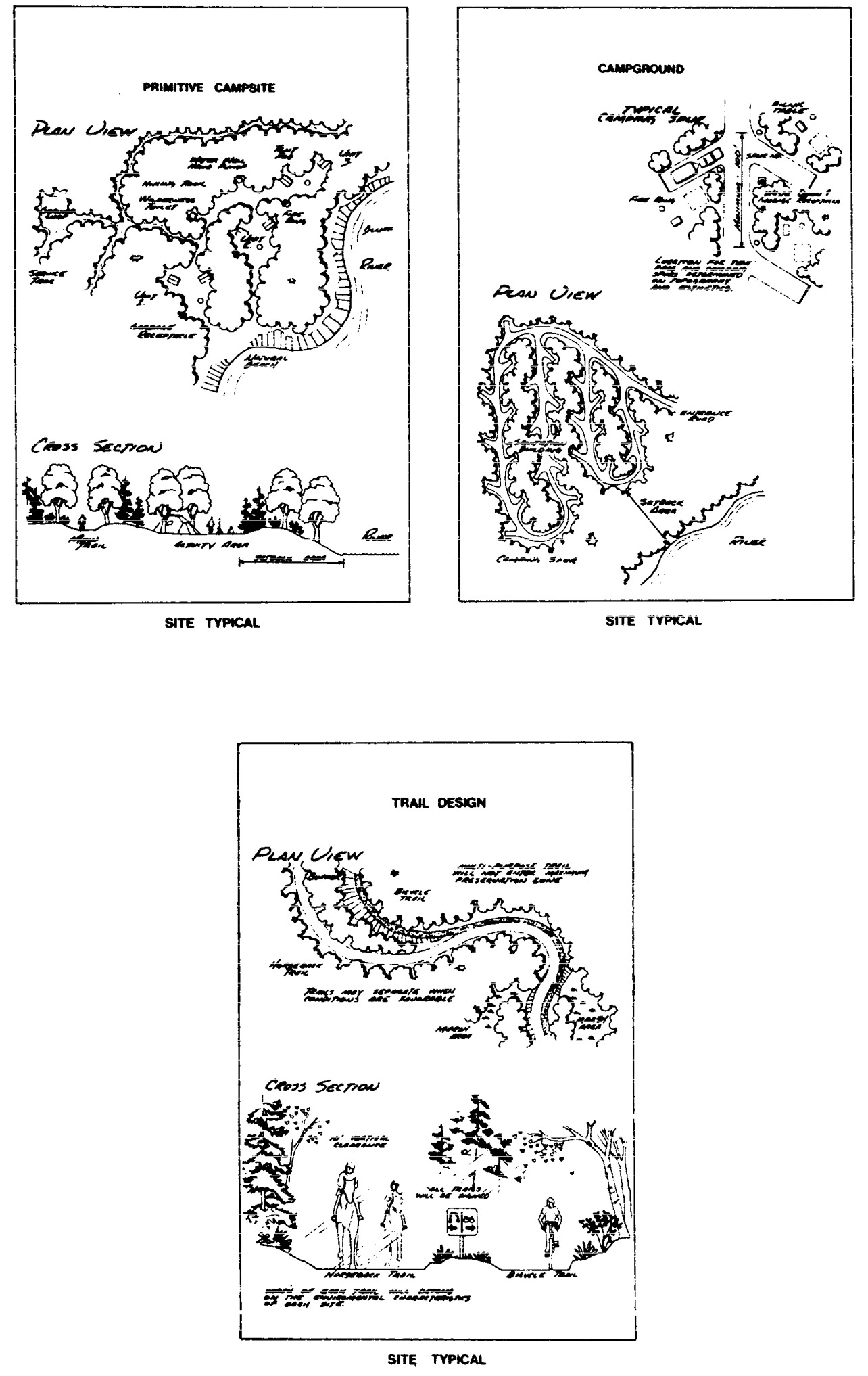
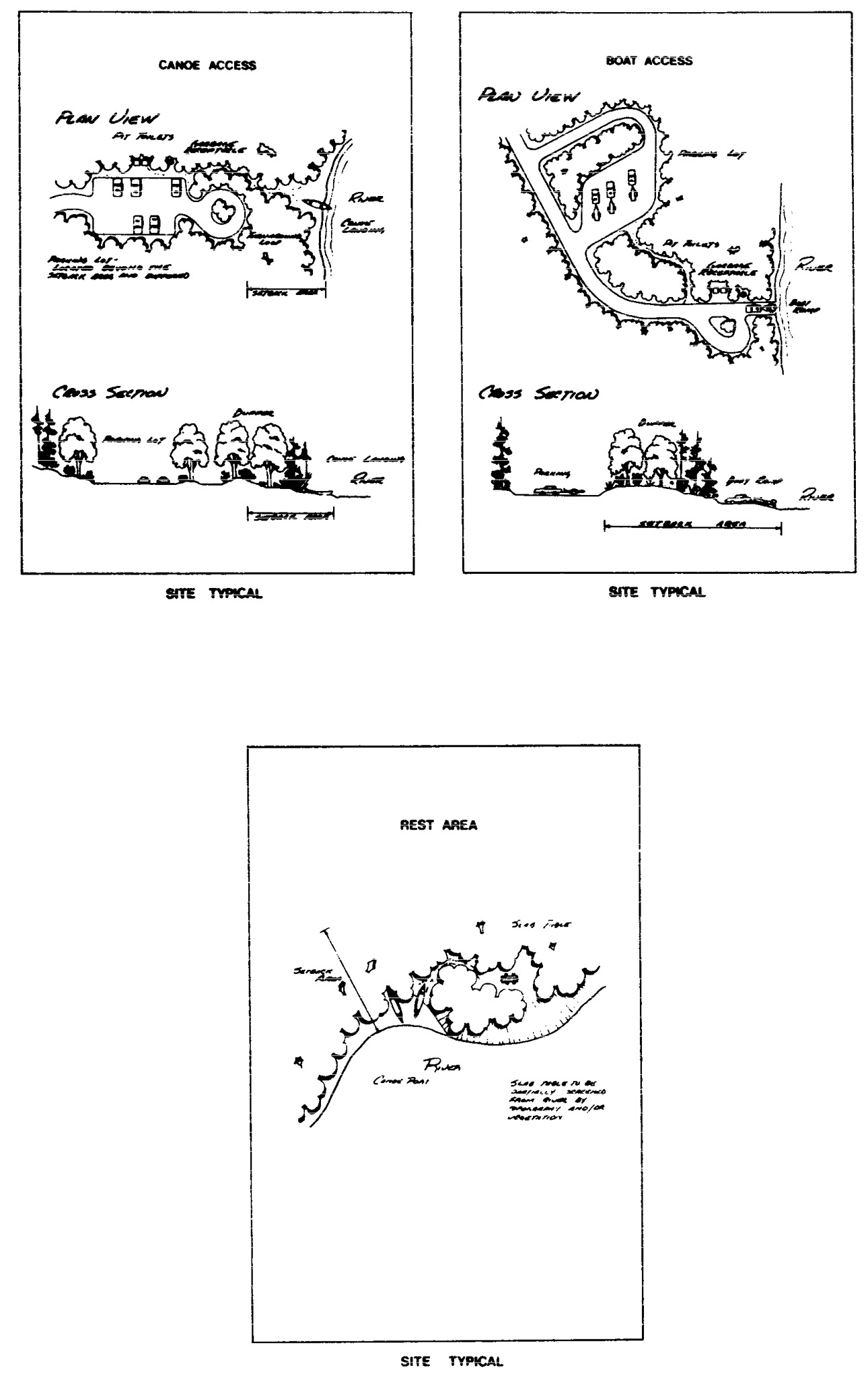
Statutory Authority:
MS s 104.35
Published Electronically:
June 11, 2008
6105.0950 LAND MANAGEMENT MAPS.
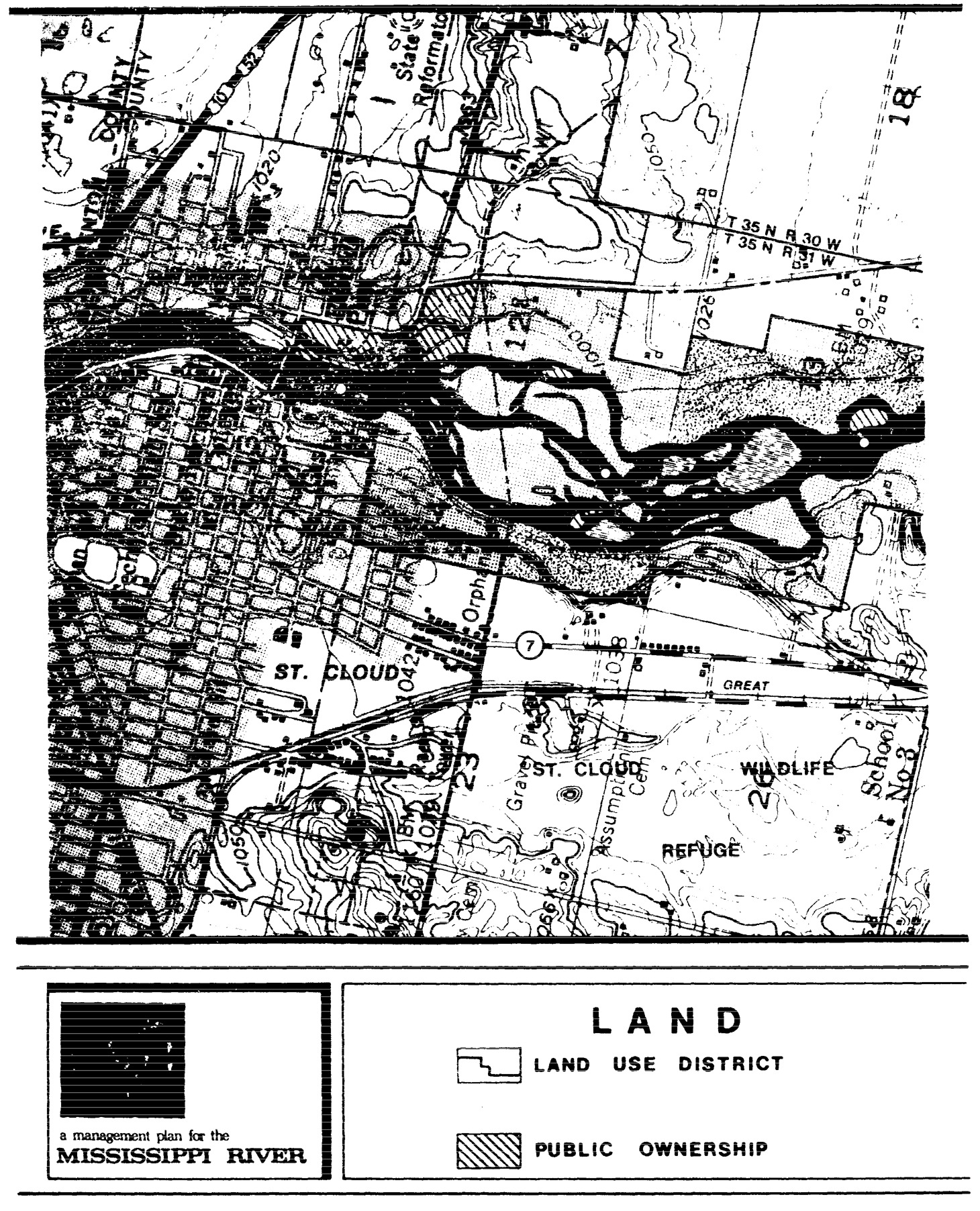
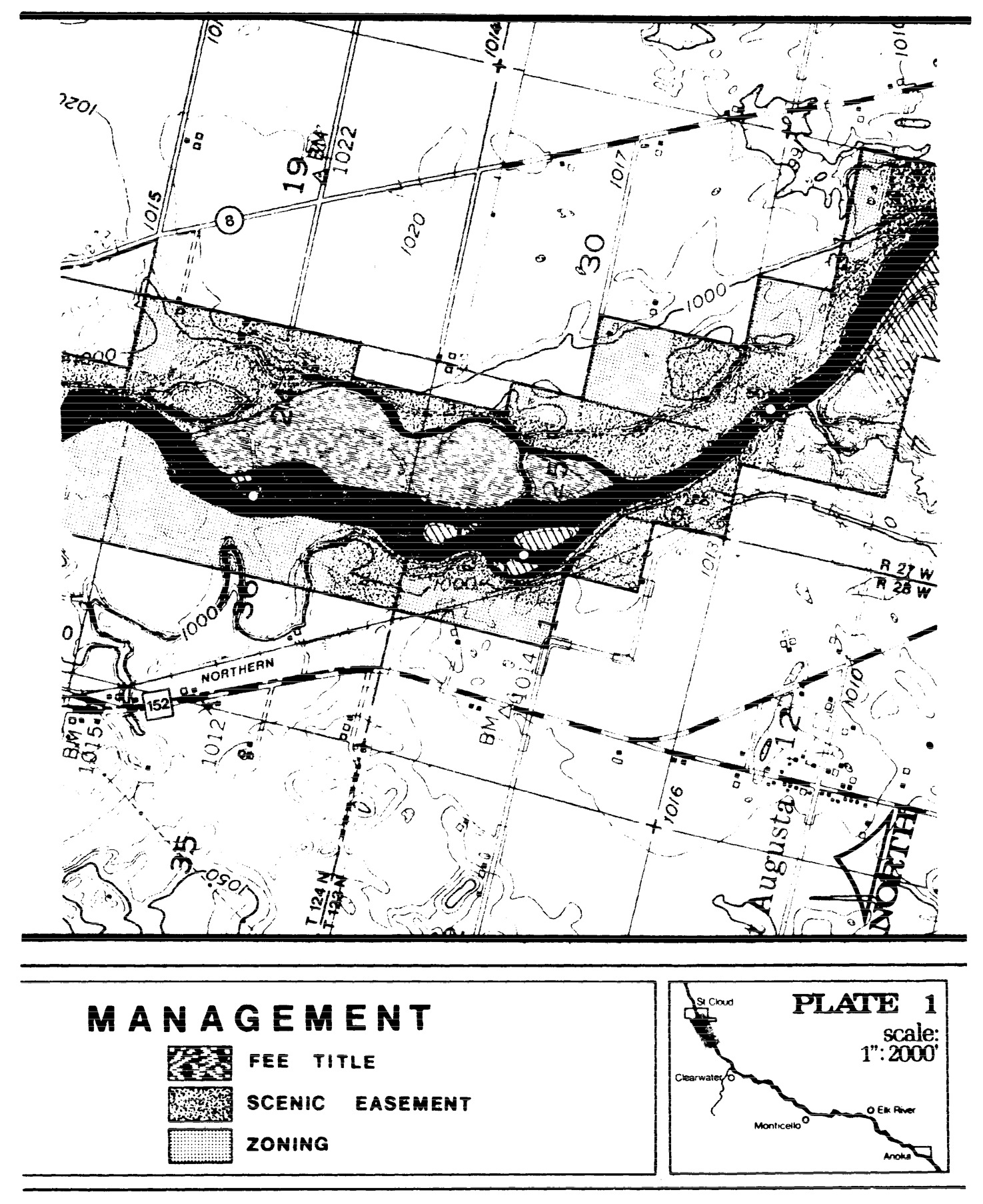
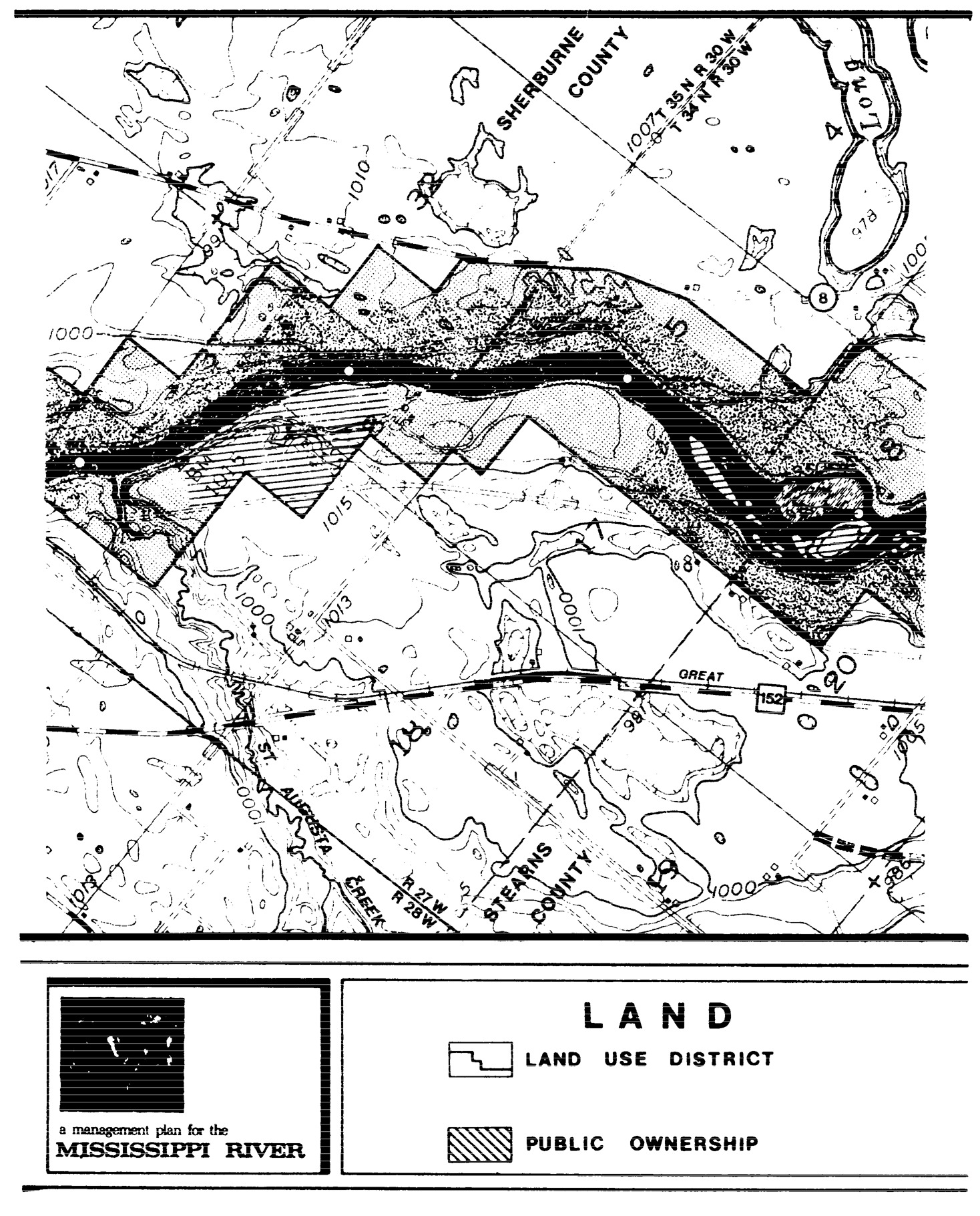
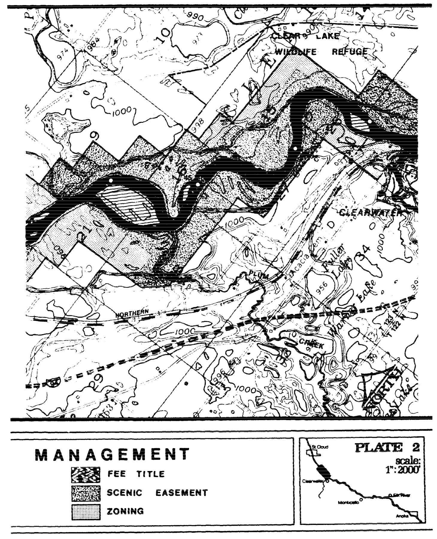
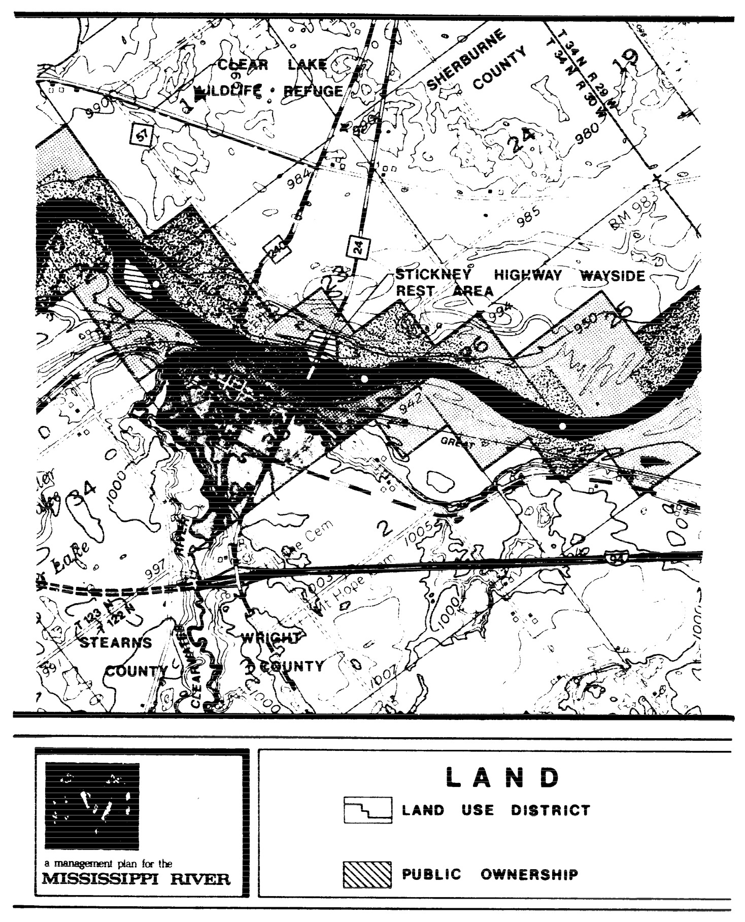
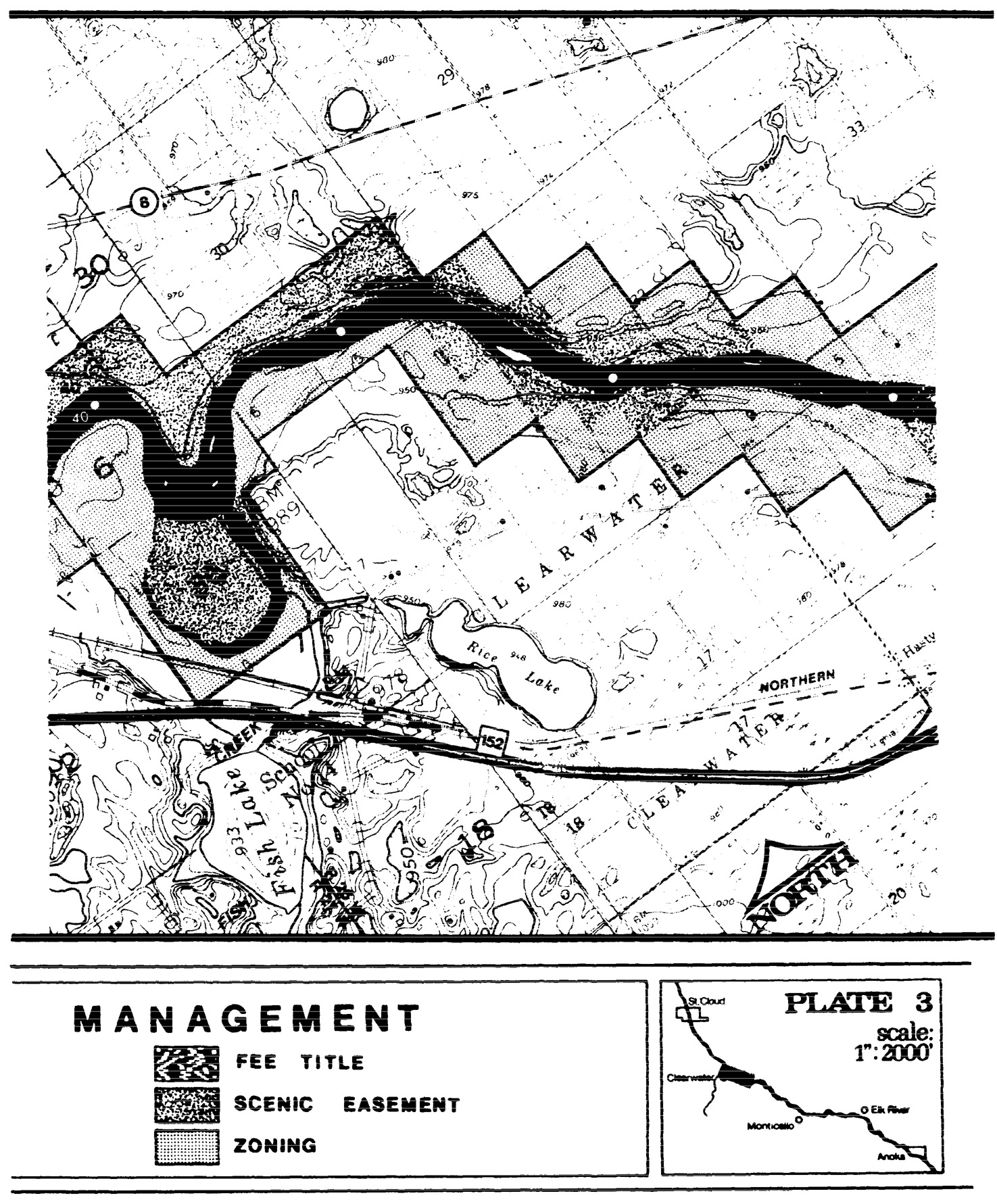
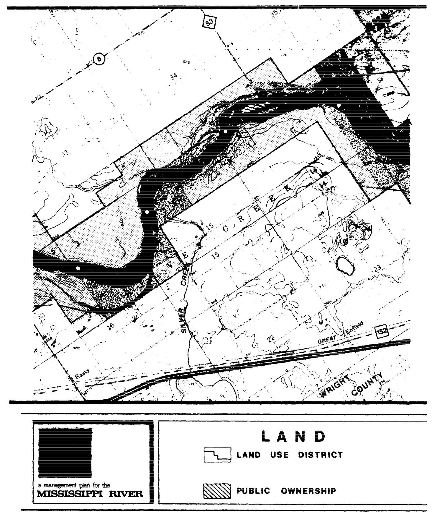
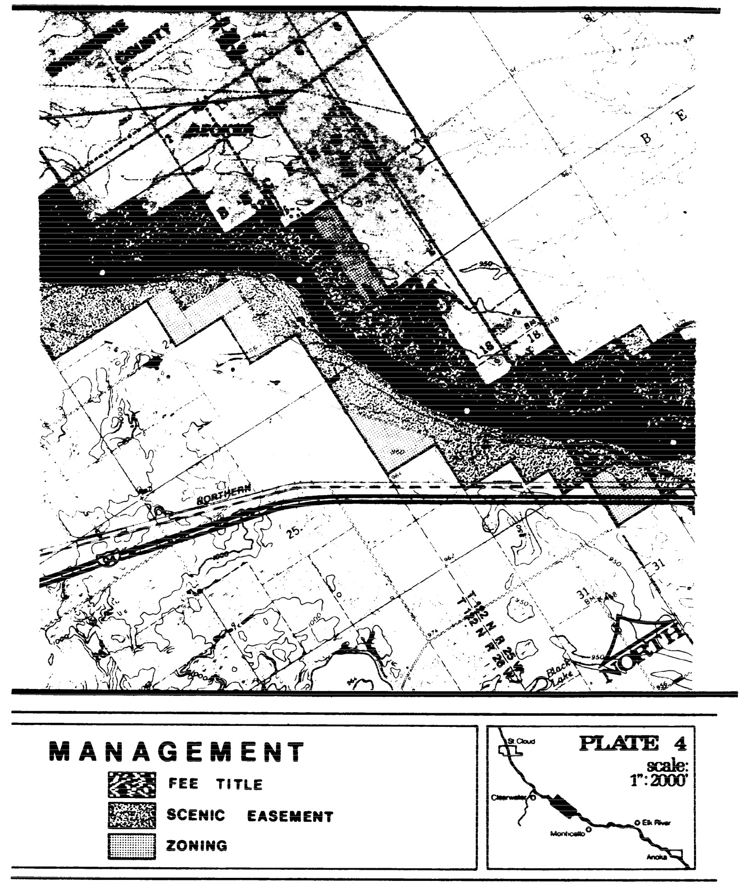

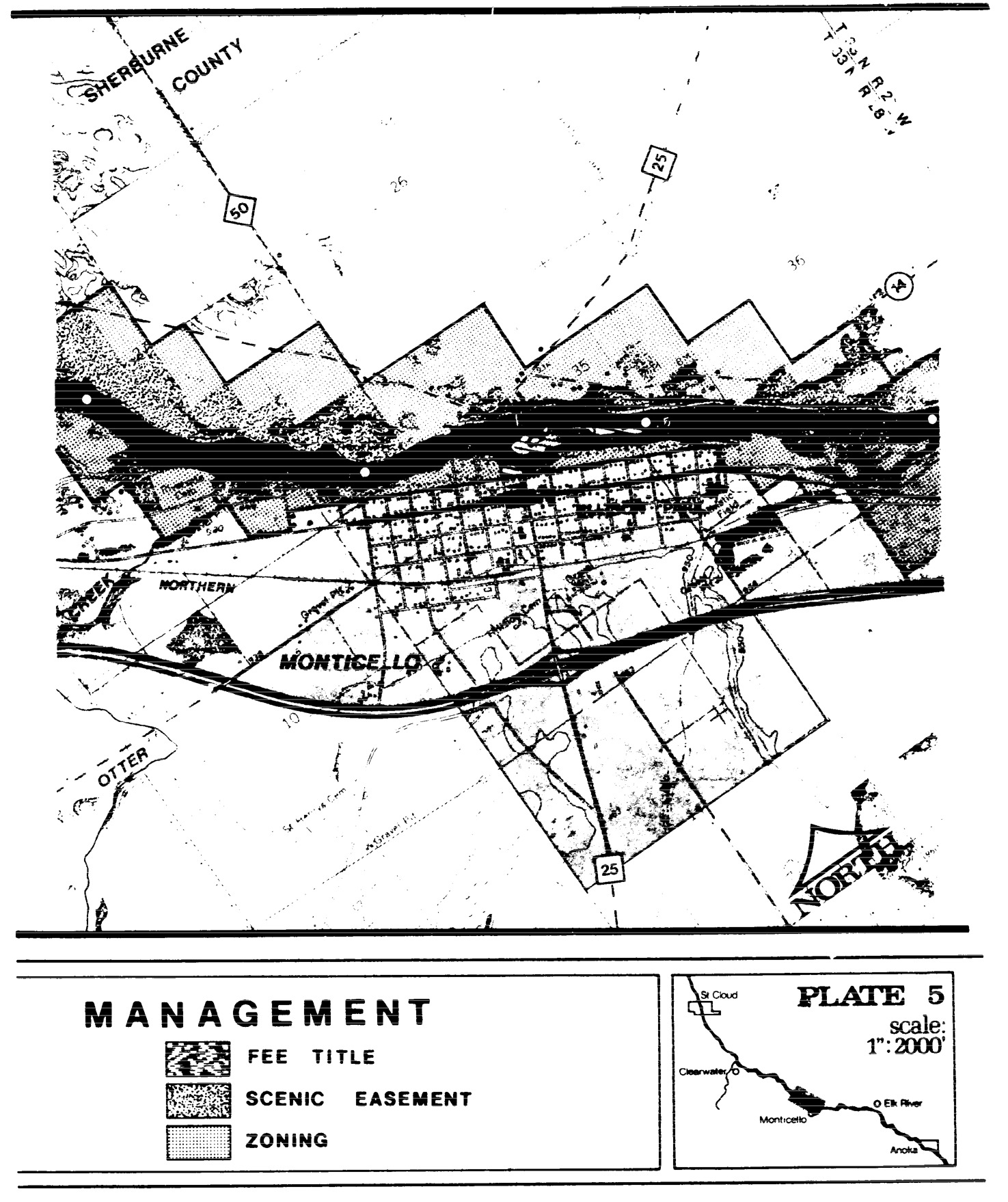
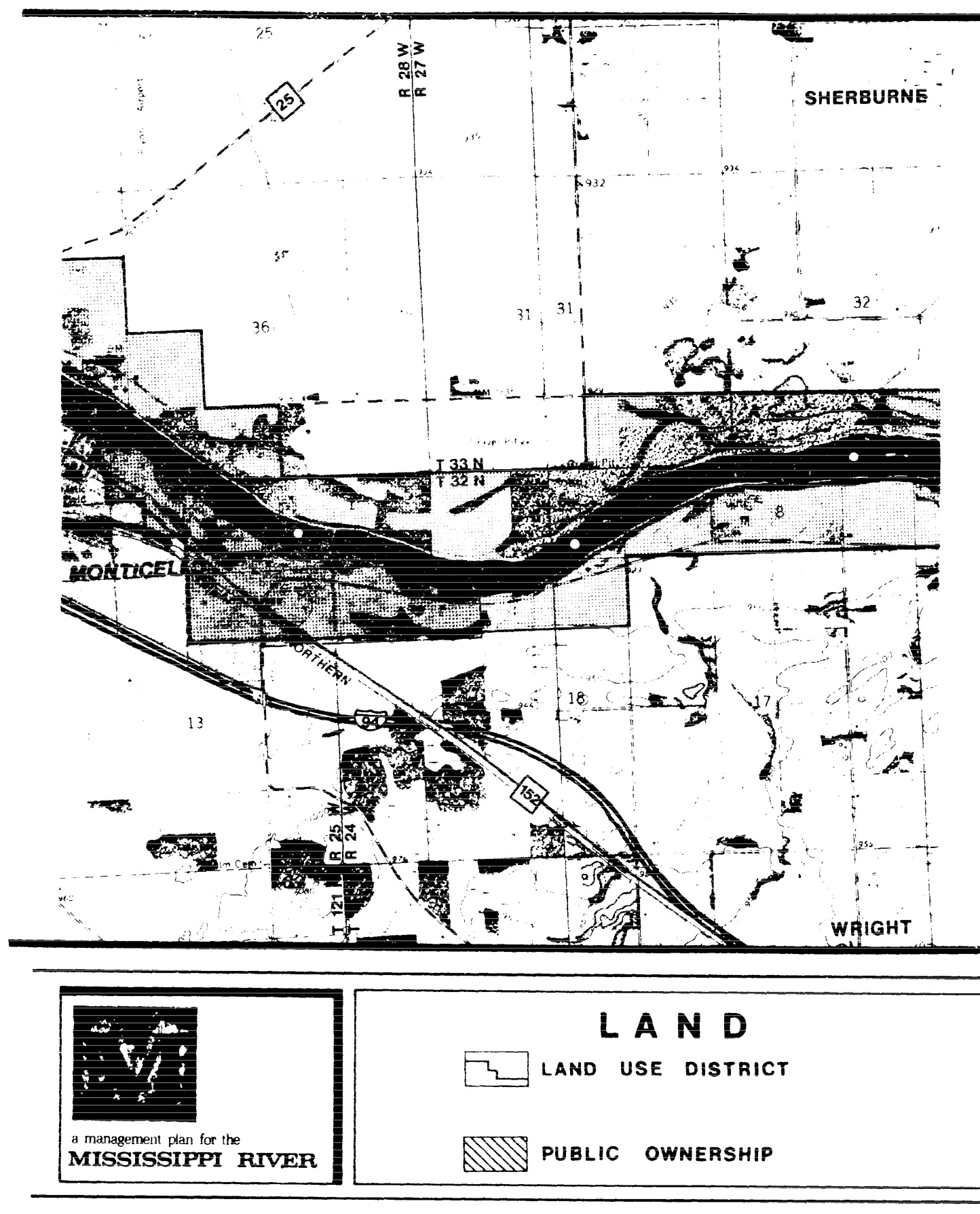
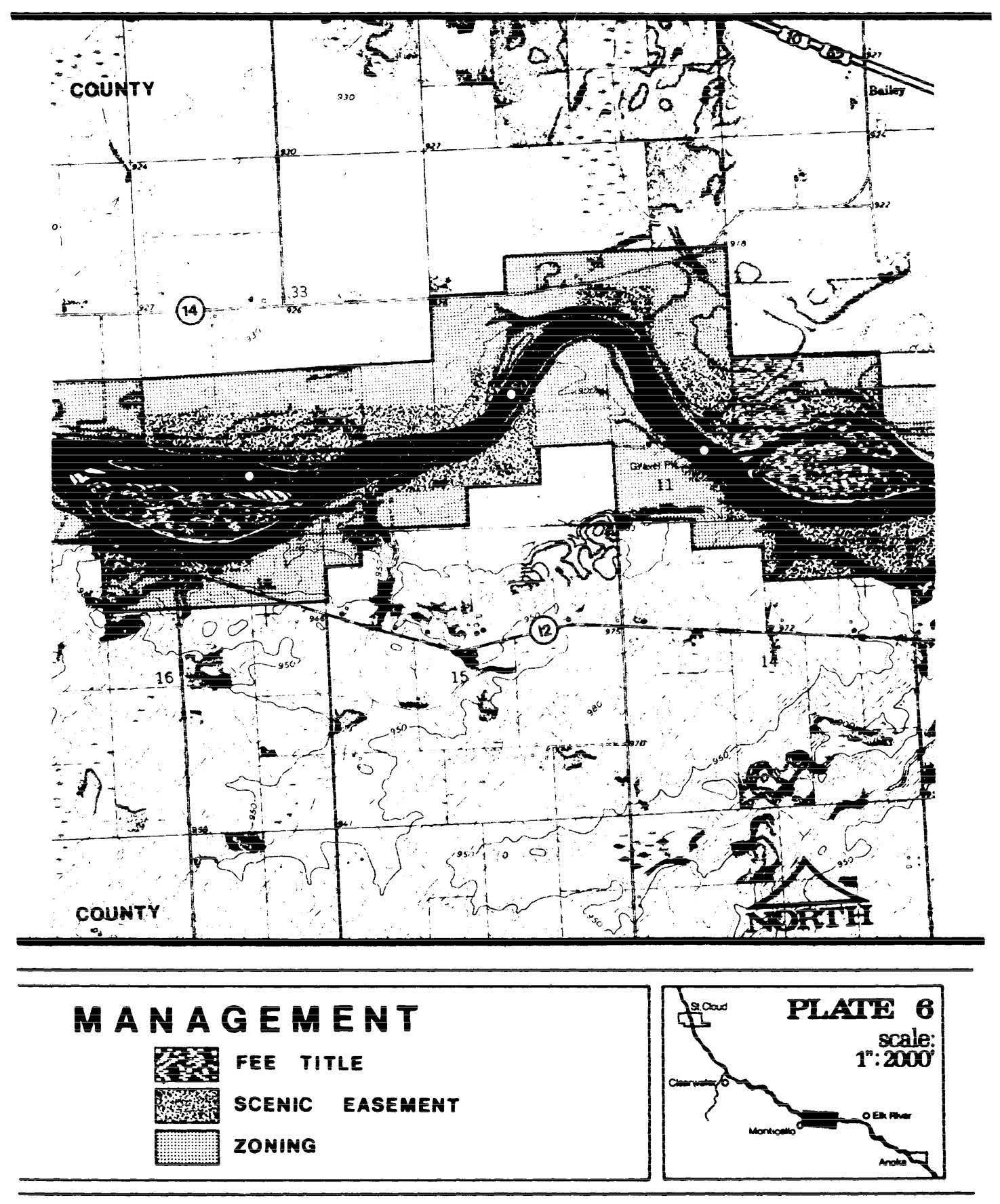
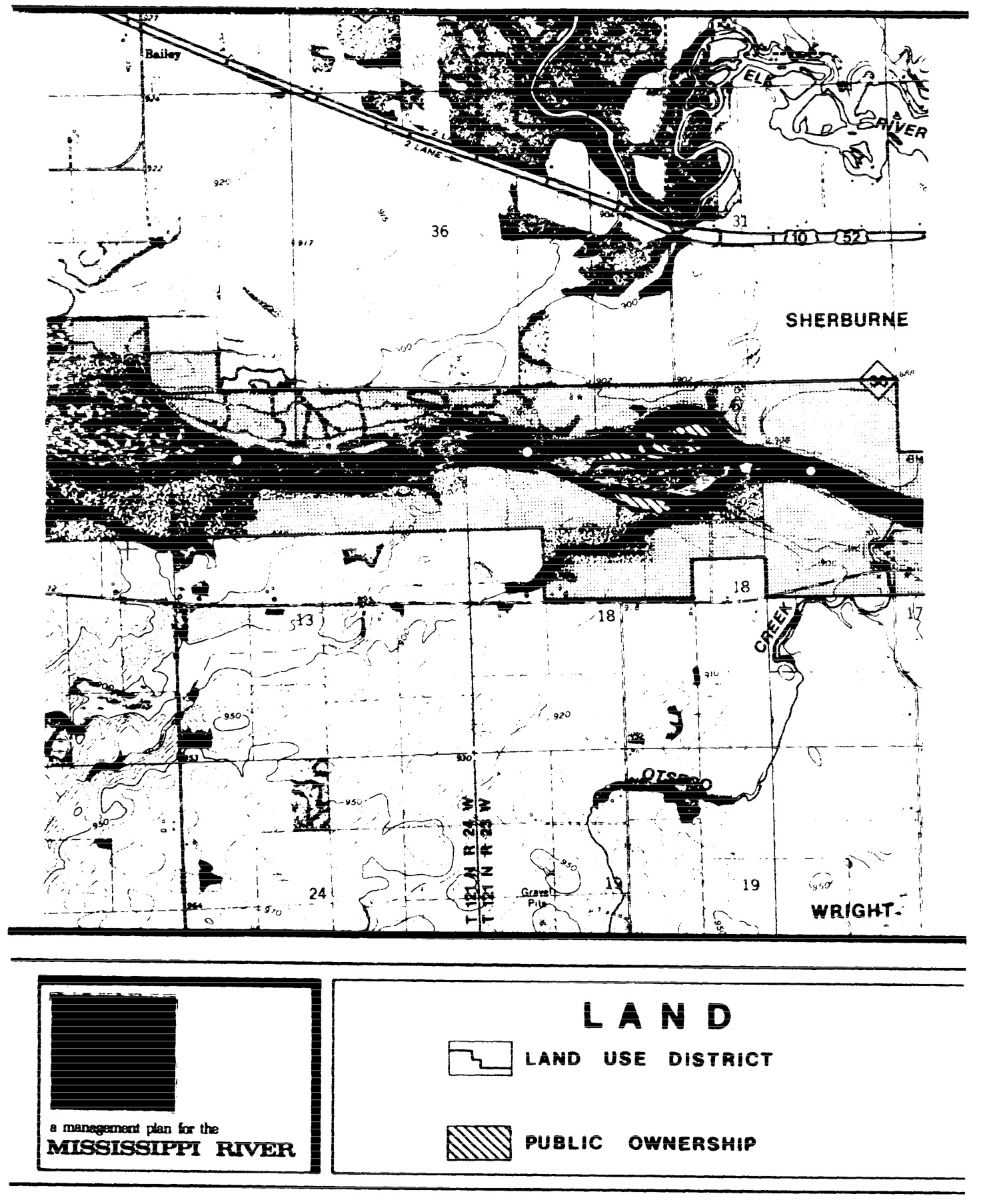
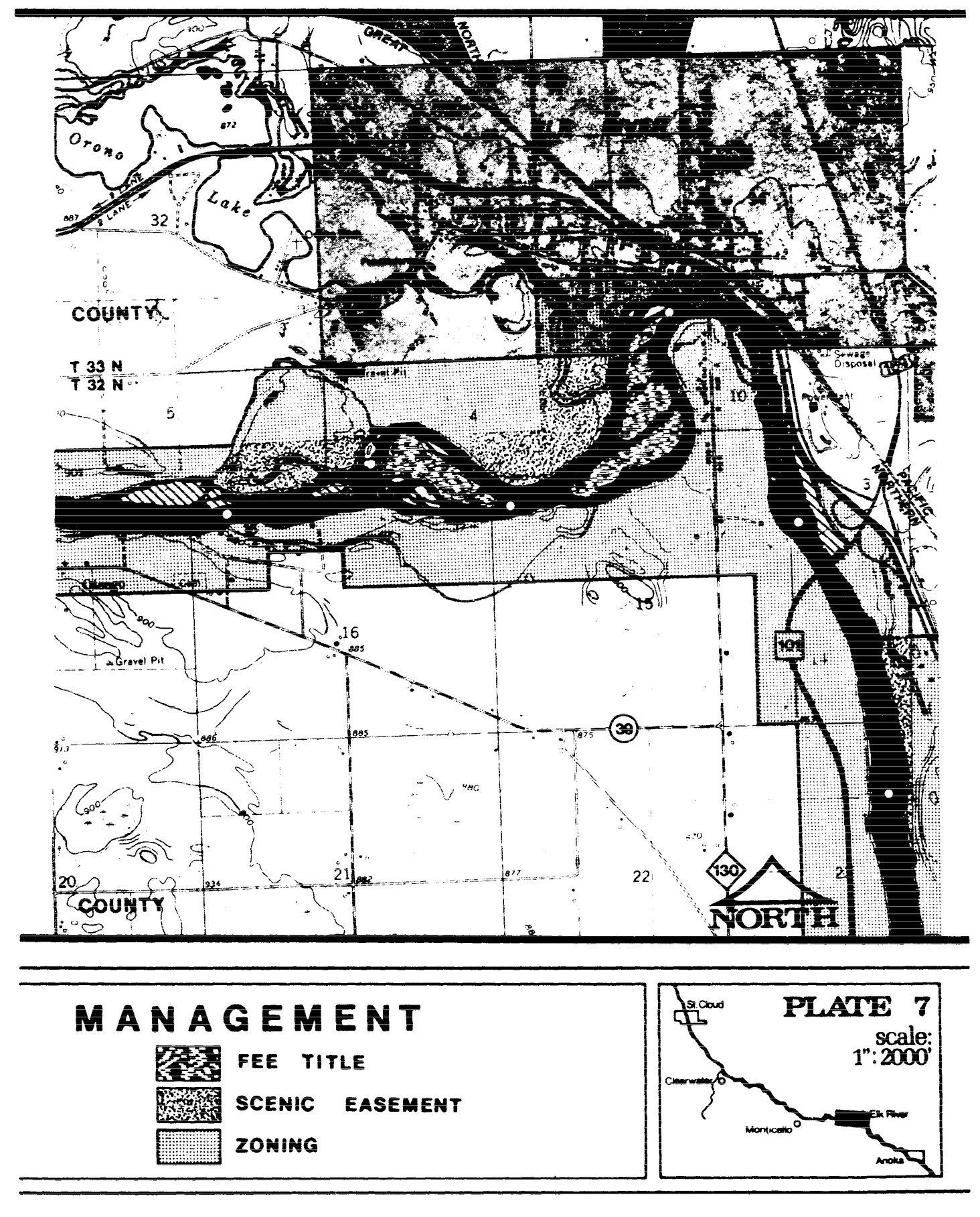
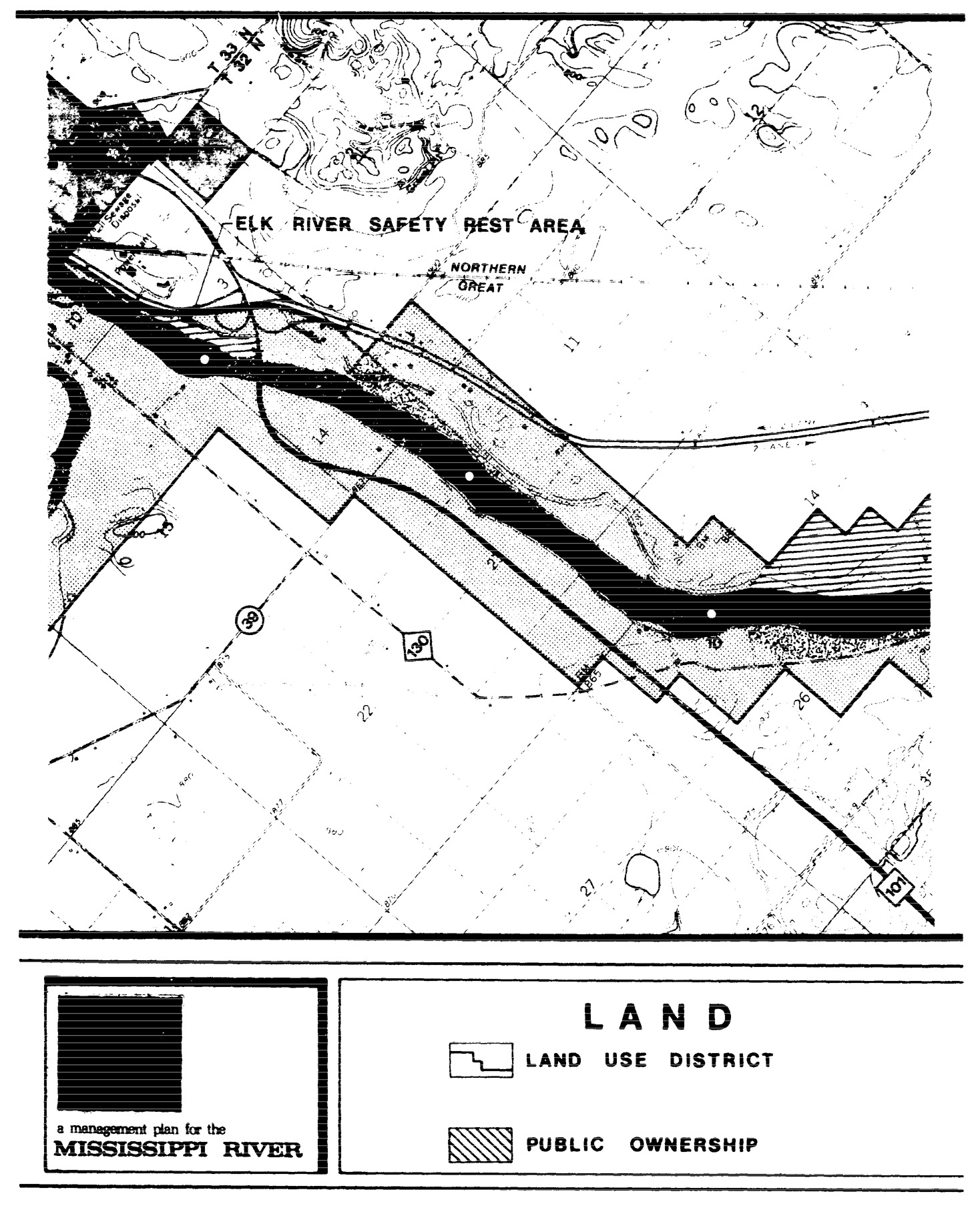
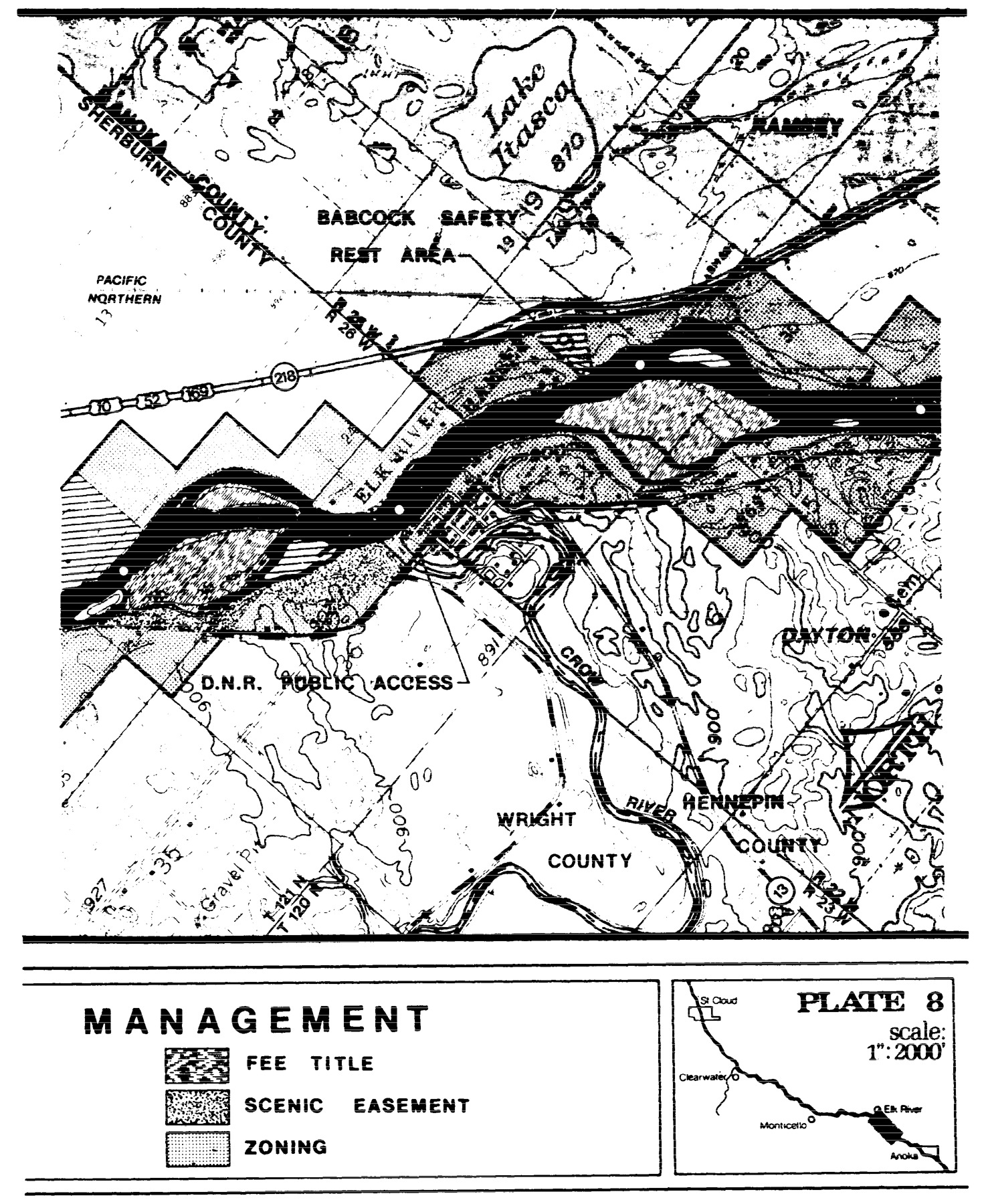
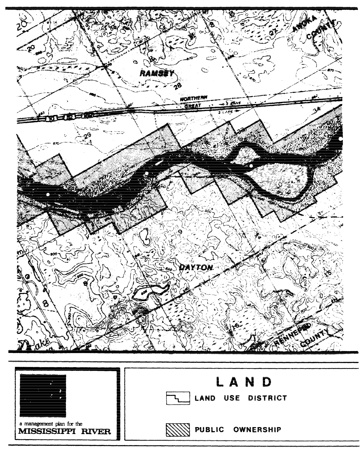
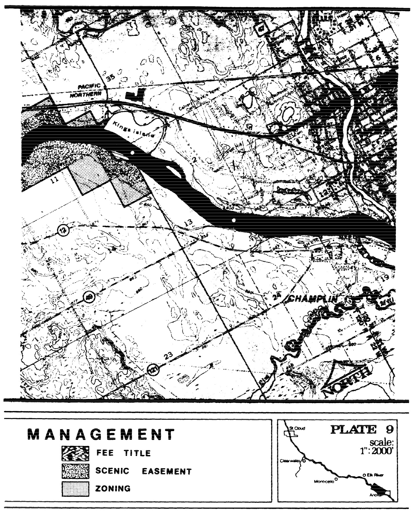
Statutory Authority:
MS s 104.35
Published Electronically:
June 11, 2008
6105.0960 RECREATION MANAGEMENT MAPS.
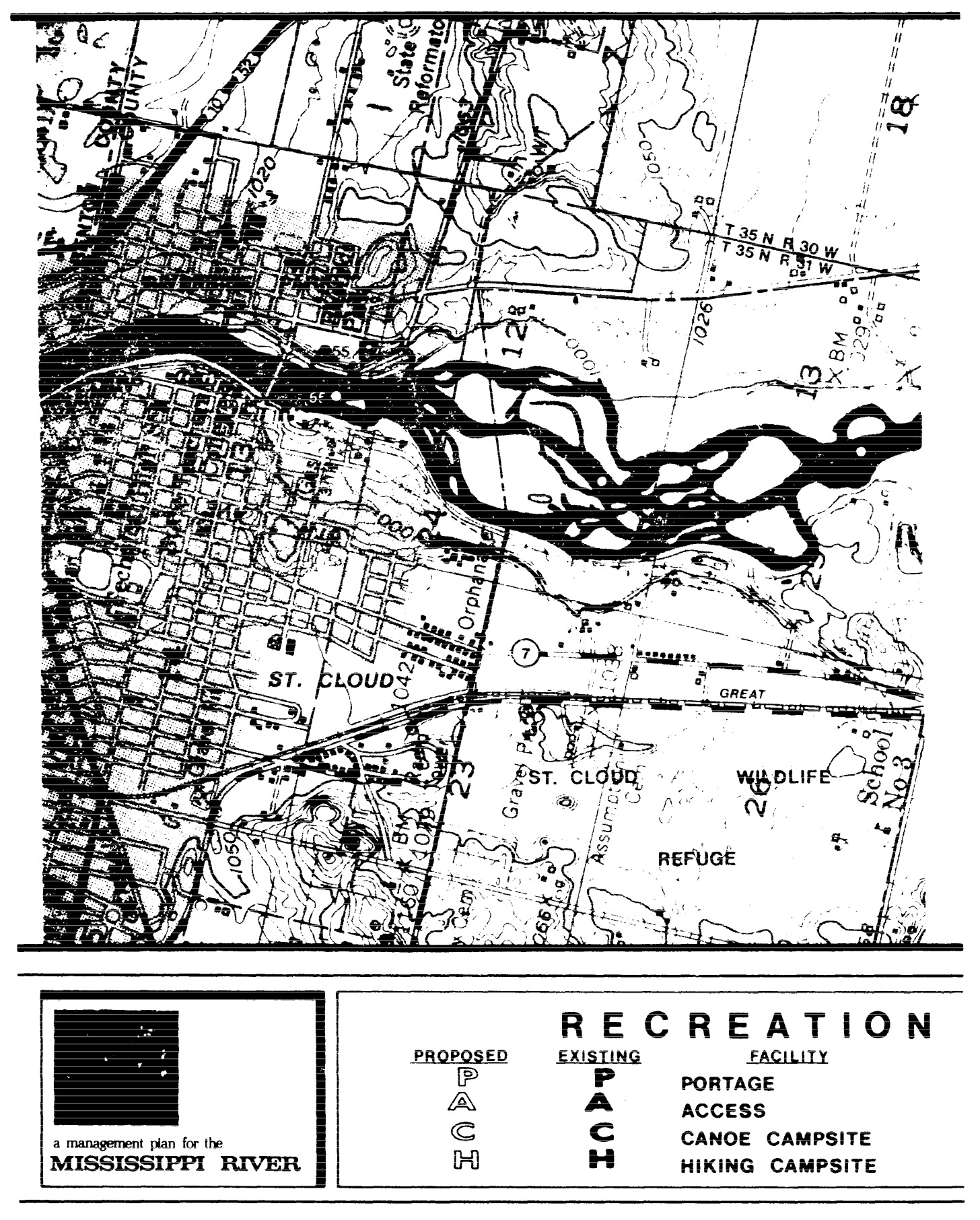
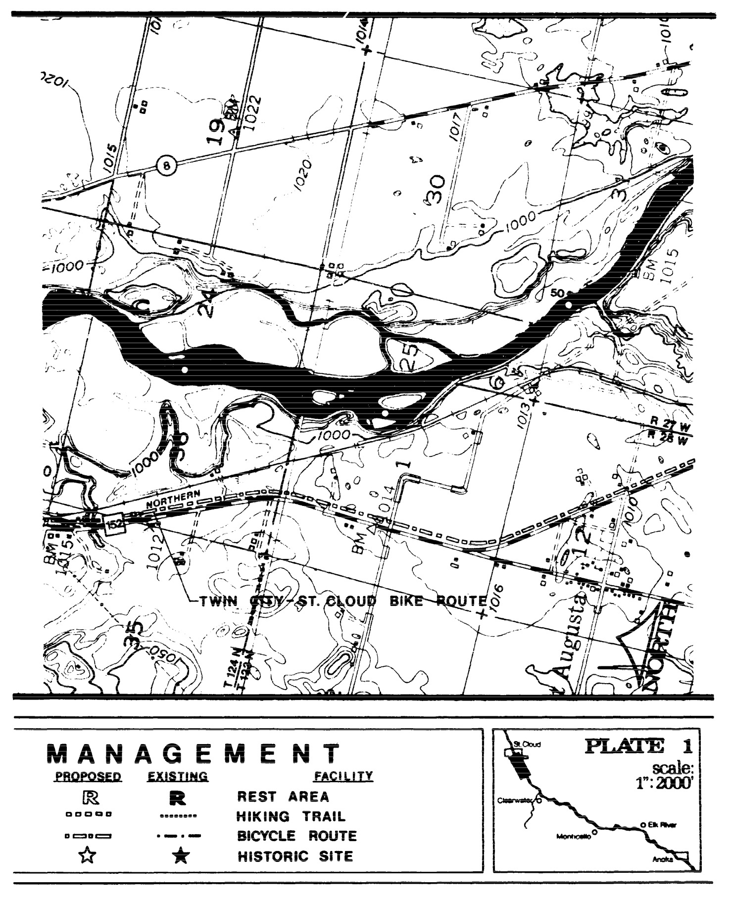
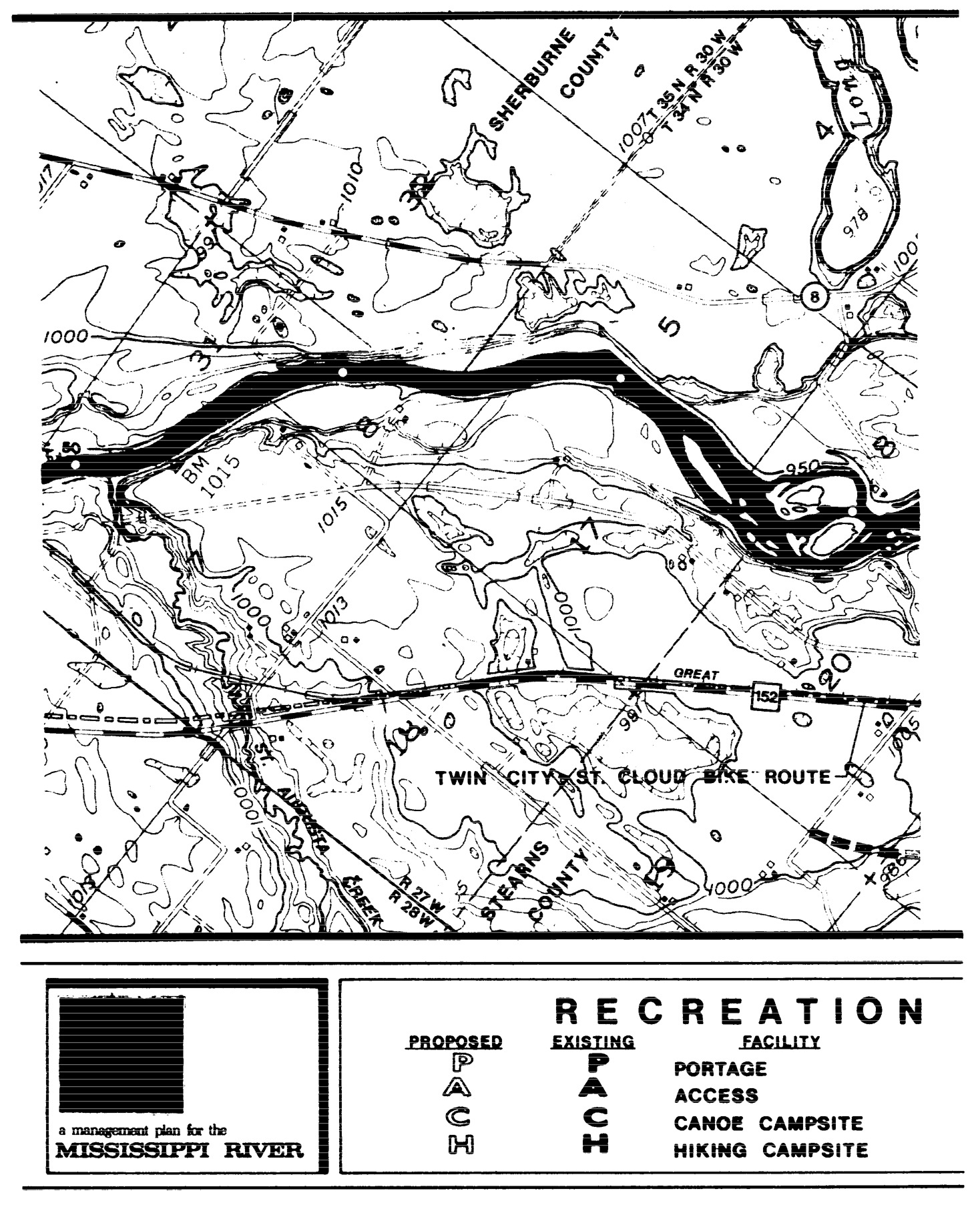
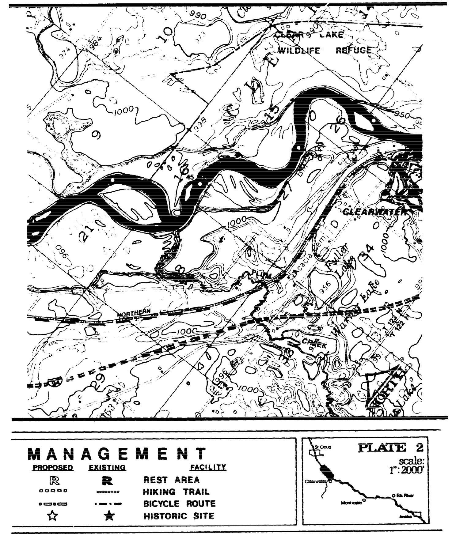
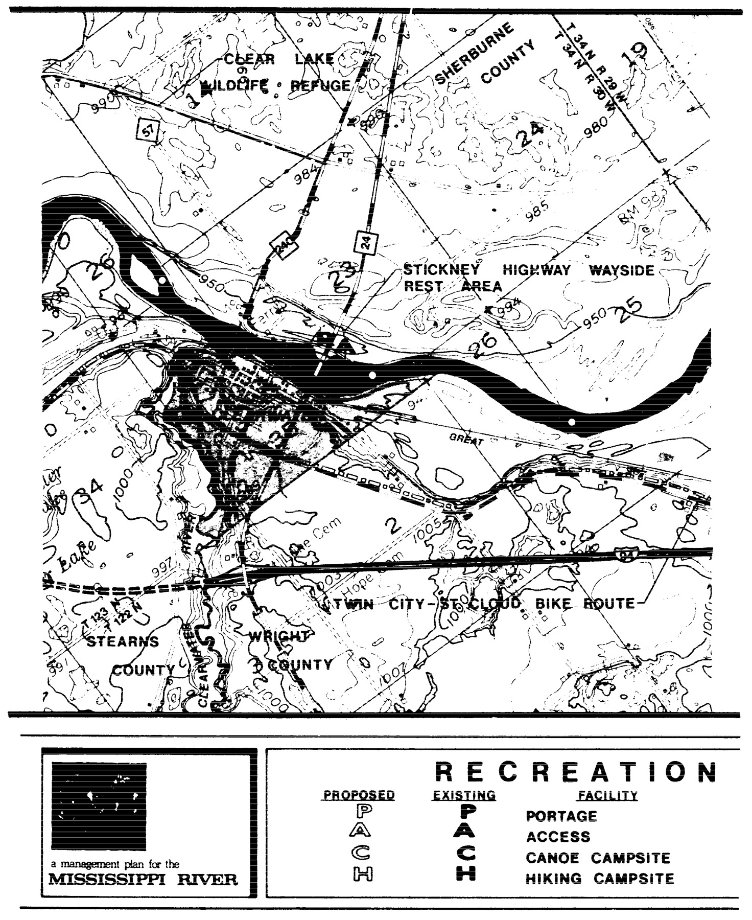
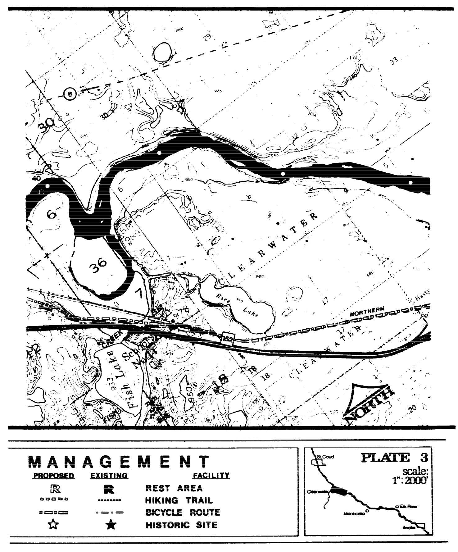
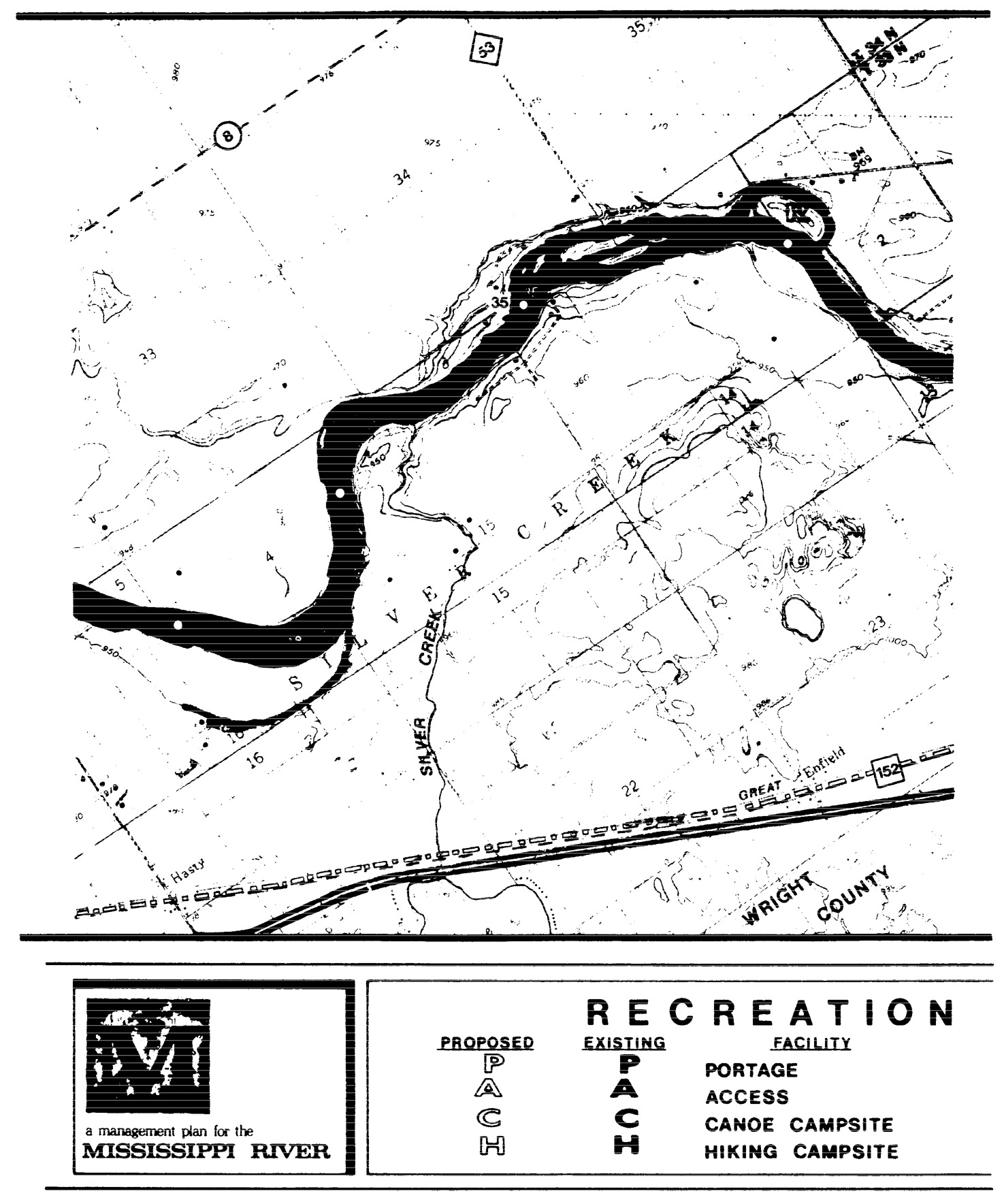
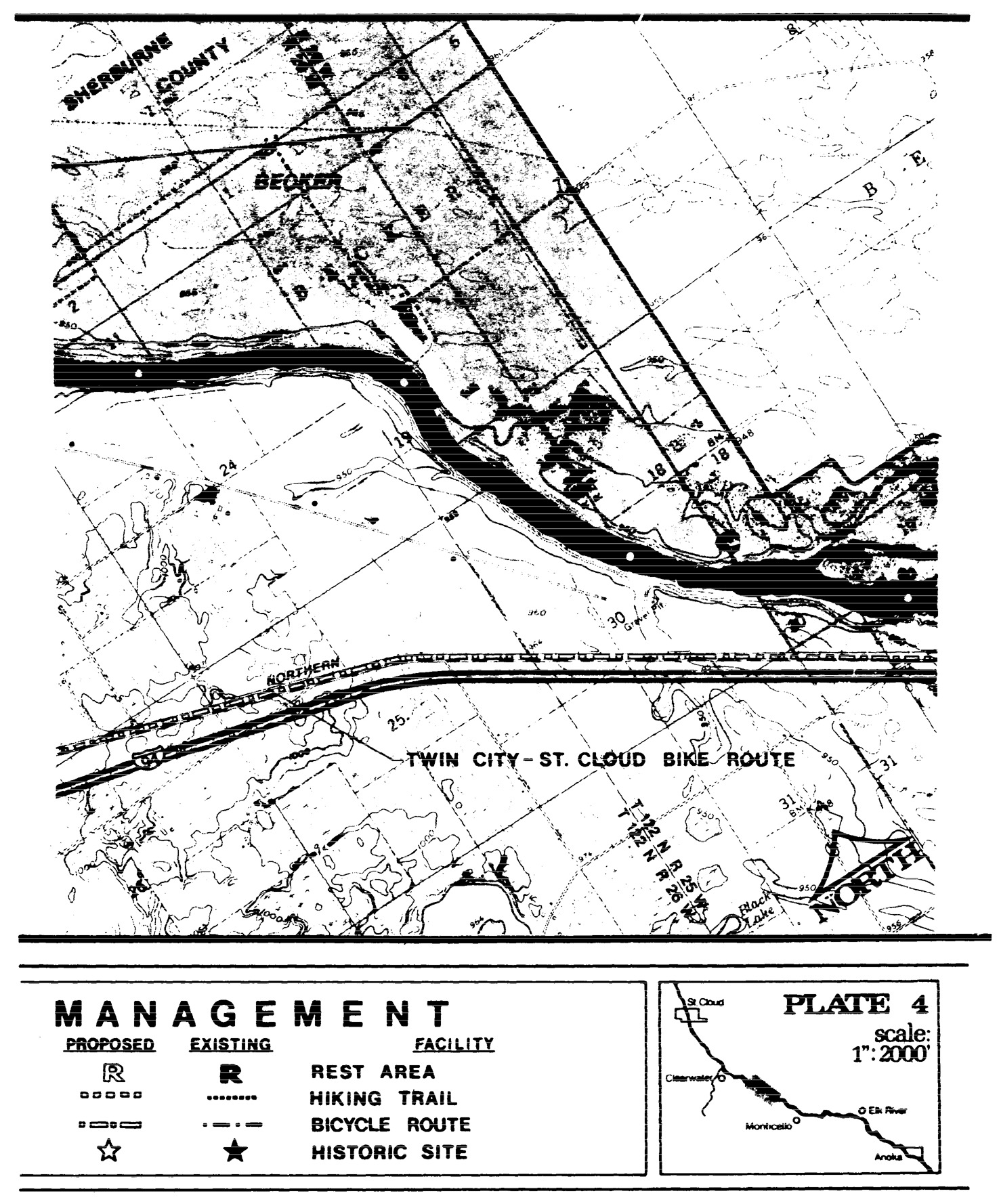
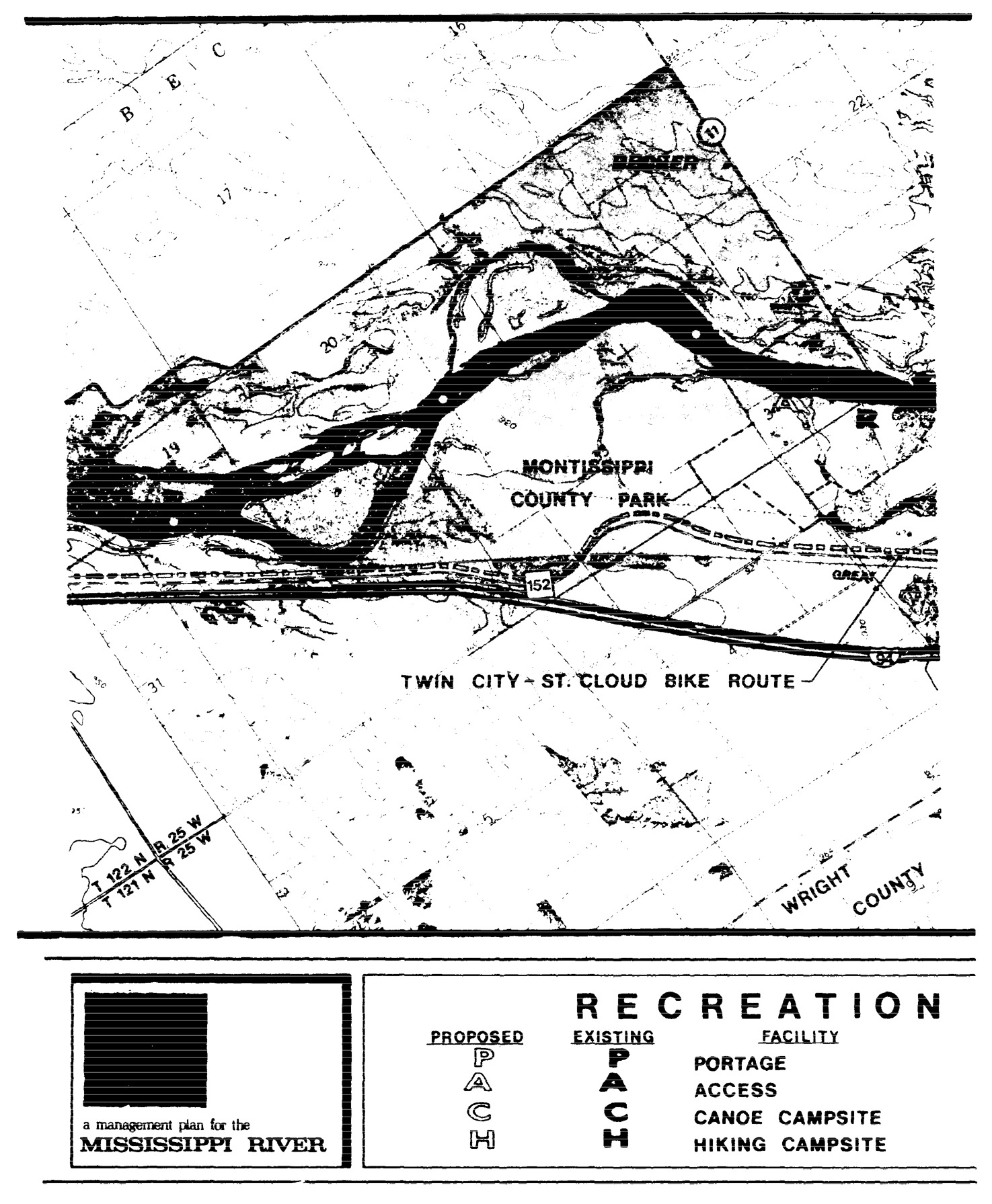
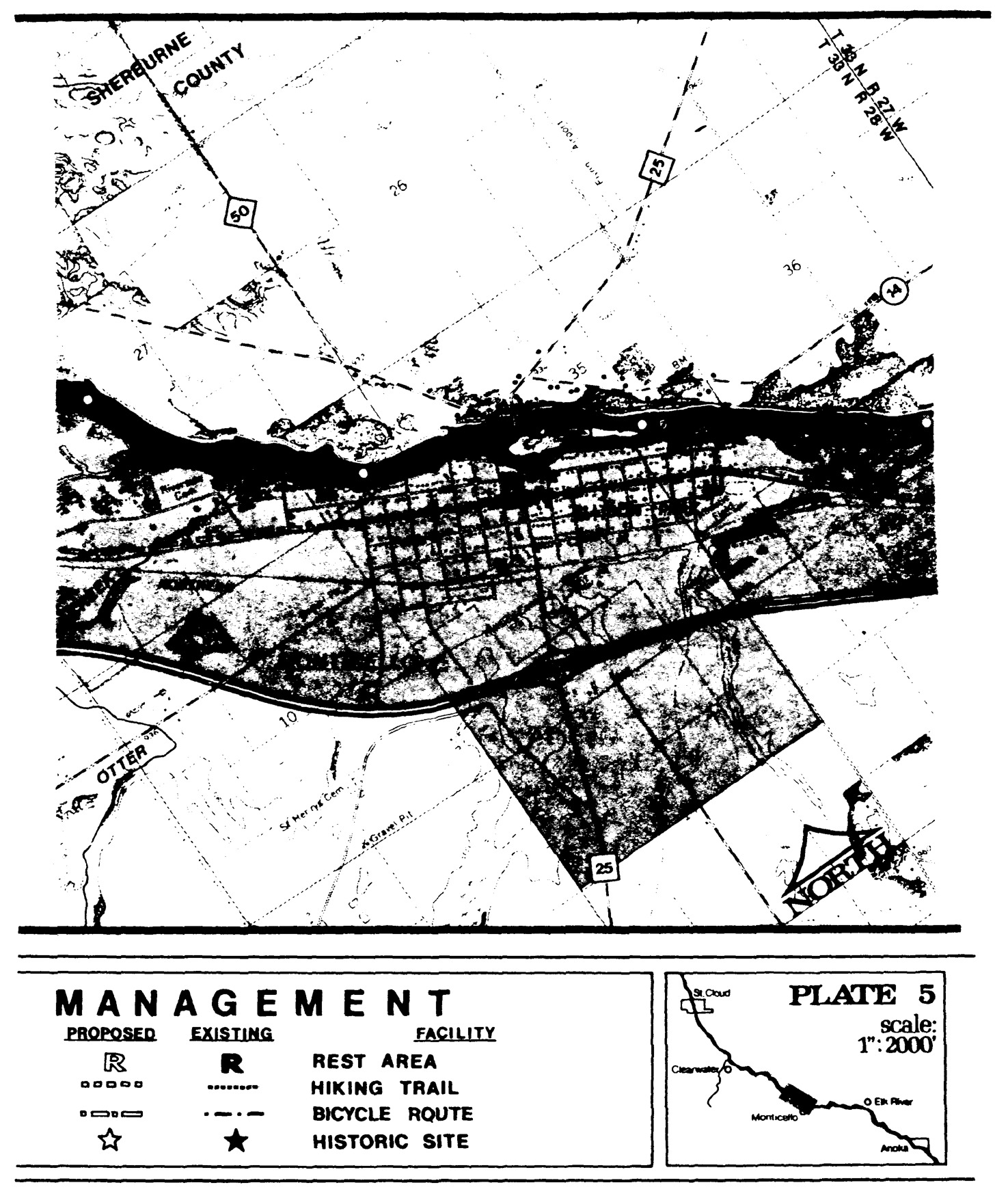
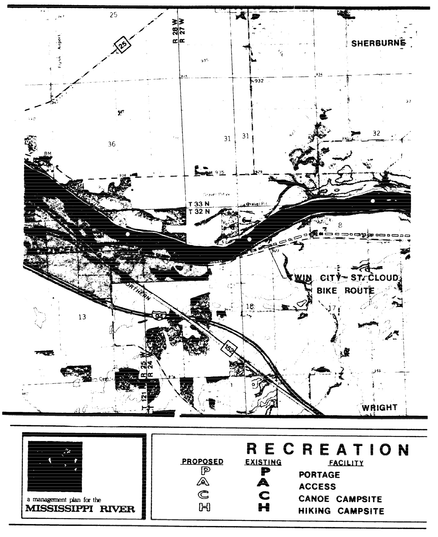
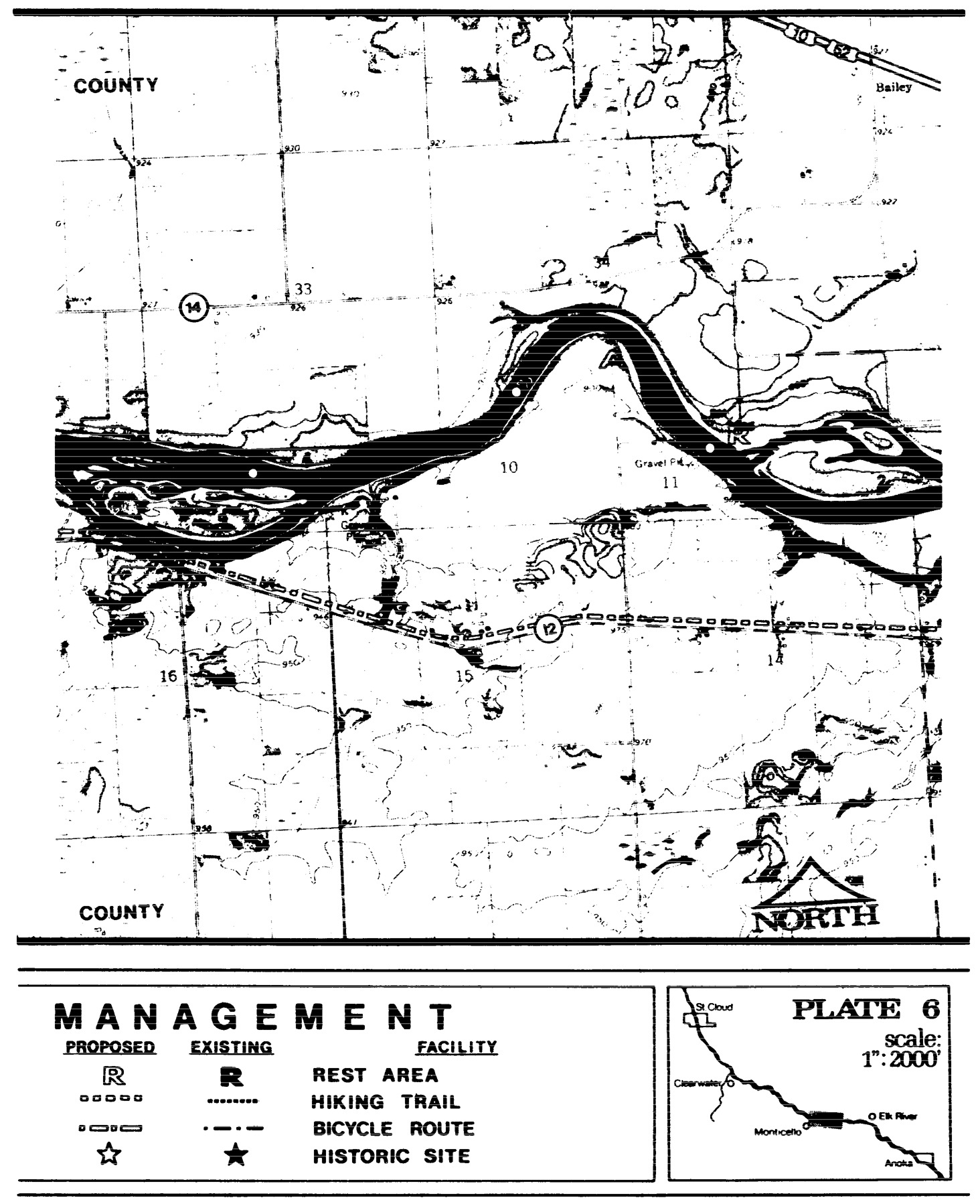
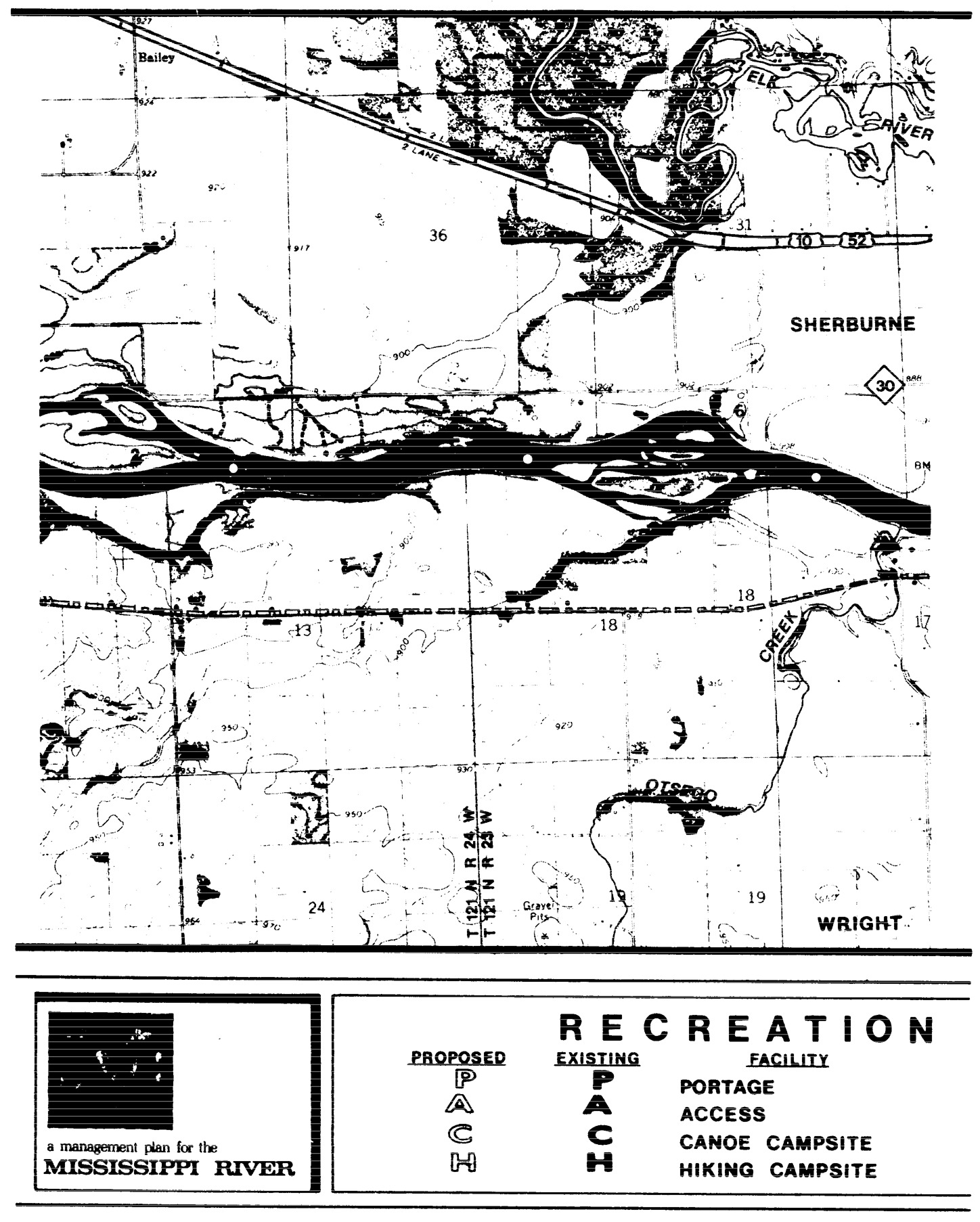
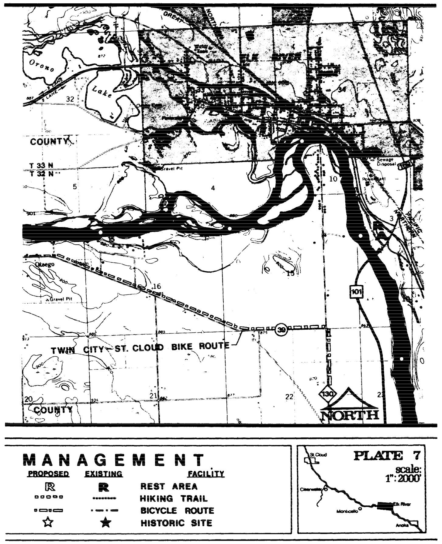
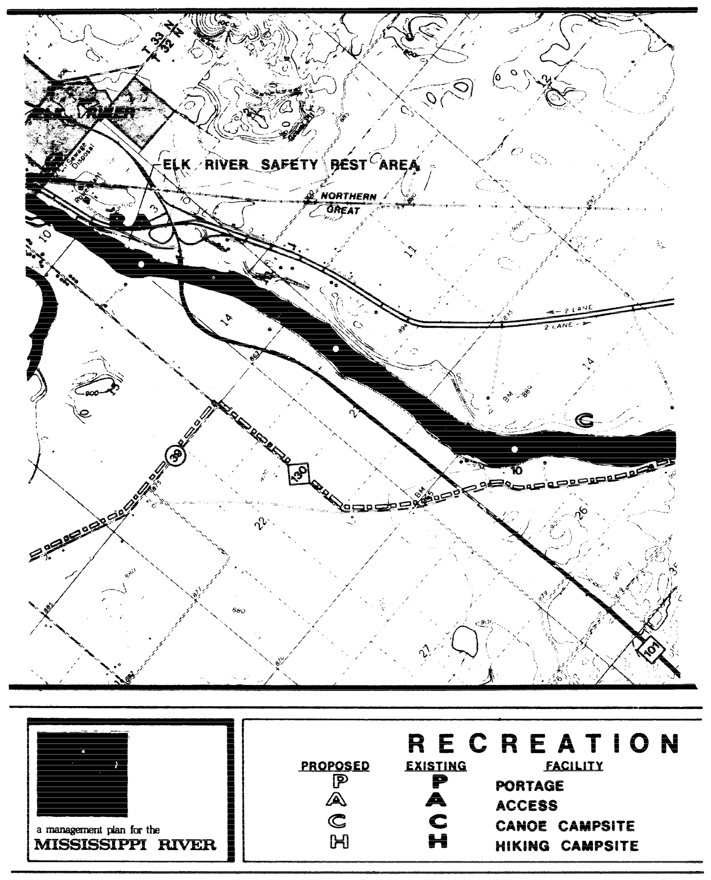
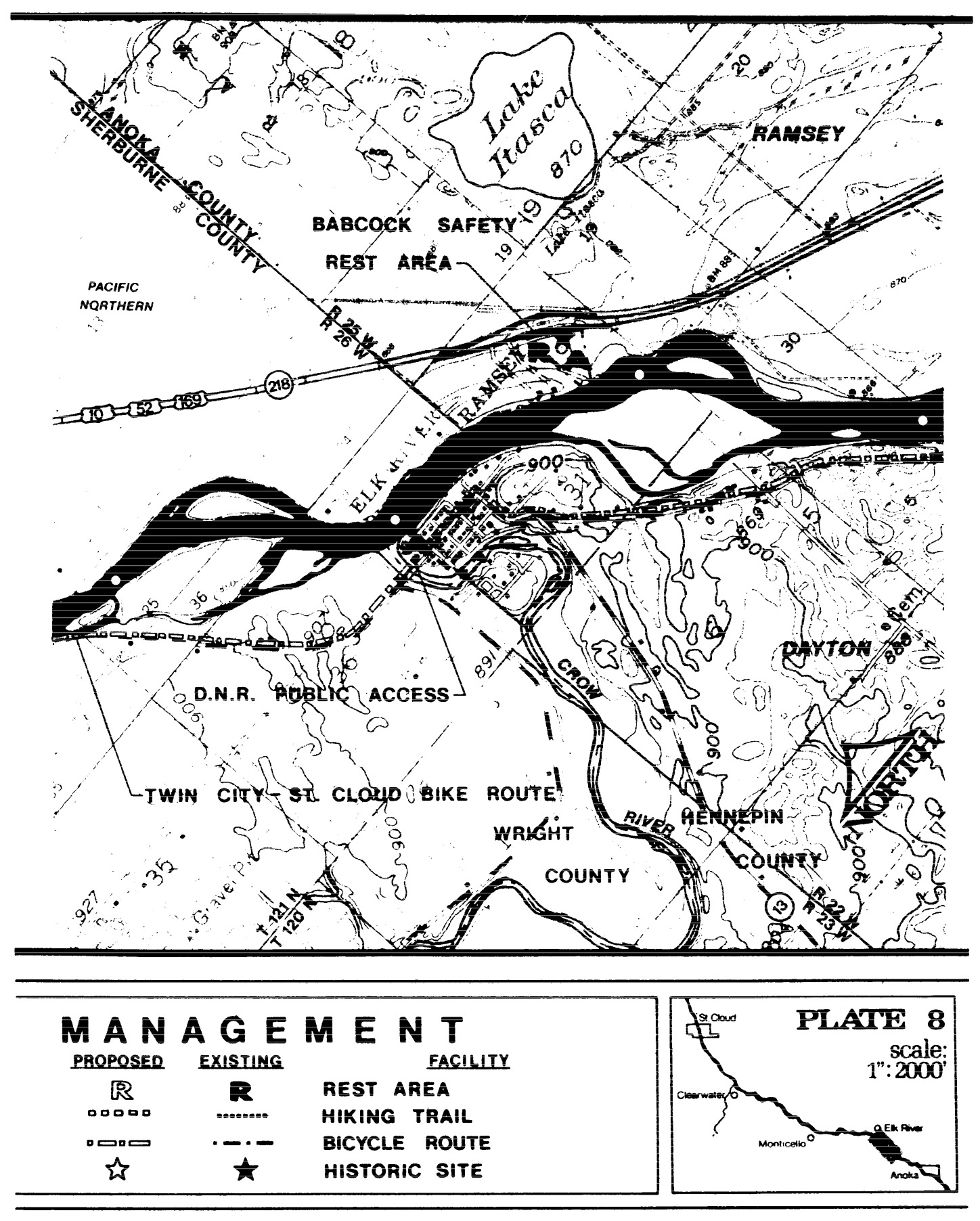
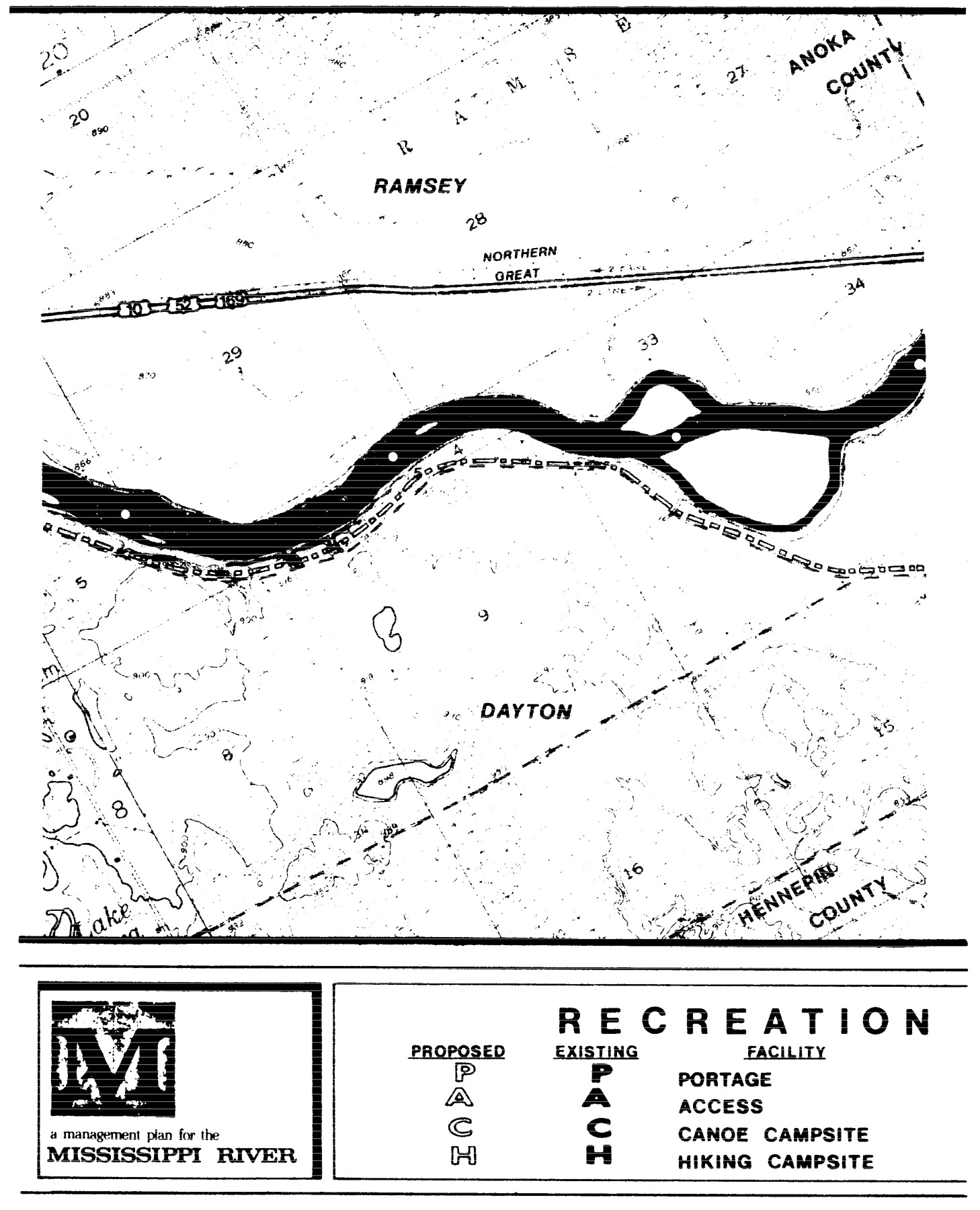
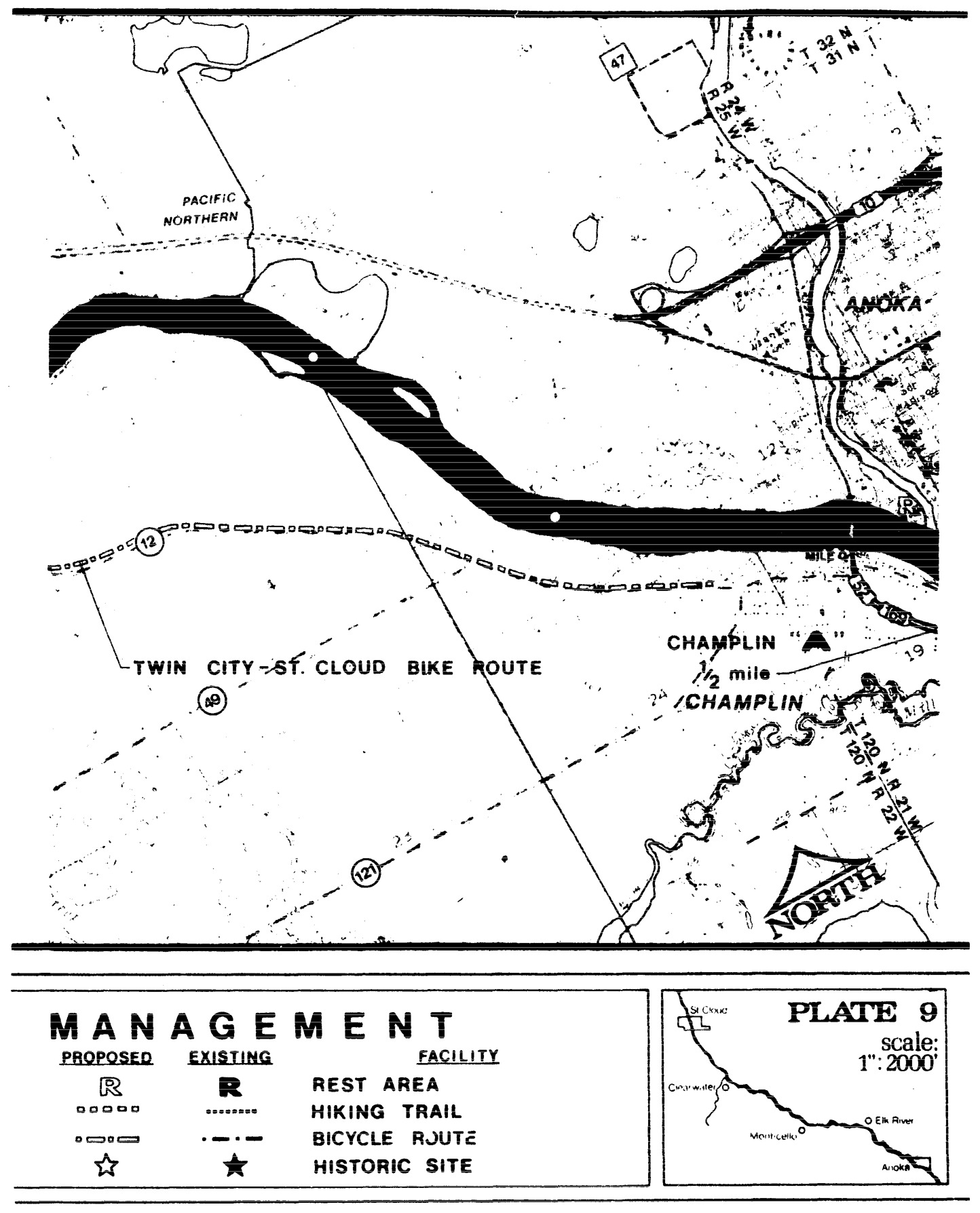
Statutory Authority:
MS s 104.35
Published Electronically:
June 11, 2008
NORTH FORK OF CROW RIVER IN MEEKER COUNTY
6105.1000 DESIGNATION OF RIVER.
That portion of the north fork of the Crow River from the spillway at the southern end of Lake Koronis to the Meeker-Wright County line, located entirely within Meeker County, is designated a component of the Minnesota wild and scenic rivers system.
Statutory Authority:
MS s 104.35
Published Electronically:
June 11, 2008
6105.1010 STATUTORY AUTHORITY.
This designation is made by the commissioner of the Department of Natural Resources pursuant to the authority of the Minnesota Wild and Scenic Rivers Act, Minnesota Statutes 1974, sections 104.31 to 104.40.
Statutory Authority:
MS s 104.35
Published Electronically:
June 11, 2008
6105.1020 SCOPE.
The designation and parts 6105.1000 to 6105.1130 apply to the river and the adjacent lands indicated in the property descriptions for the land use district.
Statutory Authority:
MS s 104.35
Published Electronically:
June 11, 2008
6105.1030 CLASSIFICATION: RECREATIONAL RIVER.
That portion of the north fork of the Crow River in Meeker County from the spillway at the southern end of Lake Koronis to the Meeker-Wright County line, is classified as recreational, in accordance with provisions of Minnesota Statutes, sections 103F.311, subdivision 4, and 103F.315, subdivision 2, and part 6105.0060.
Published Electronically:
June 11, 2008
6105.1040 LAND USE MANAGEMENT.
Subpart 1.
Adoption of land use district.
The commissioner of the Department of Natural Resources hereby adopts the recreational river land use districts as identified in the land use district property descriptions. The land use district was derived in accordance with part 6105.0070, subpart 2, item B.
A.
The regulations contained in parts 6105.0010 to 6105.0250 and this management plan shall be applicable to all lands which are unincorporated at the time of designation within the recreational river land use district.
Subp. 2.
Building height.
The maximum building height restriction contained in part 6105.0110, subpart 3, item D, shall not apply to buildings used primarily for agricultural purposes.
Subp. 3.
Grading and filling.
The grading and filling provisions shall be enforced by local ordinance, which shall require a grading and filling permit. Filling or drainage of federally determined type III-V wetlands (in accordance with U.S. Department of Interior circular No. 39) shall not be allowed within the land use district. A map showing the location and classification of these wetlands shall be provided to the local authority by the commissioner of the Department of Natural Resources.
Statutory Authority:
MS s 104.35
Published Electronically:
October 8, 2013
6105.1050 LAND ACQUISITION.
Subpart 1.
Scenic areas.
The commissioner of the Department of Natural Resources hereby adopts the scenic areas, as identified in the scenic areas property descriptions, as priority areas for land or land interest acquisition.
A.
All lands shown as scenic areas are recommended for scenic easement acquisition. However, in those areas where recreational sites are needed, fee title to the lands may be acquired, when possible.
B.
Because acquisition of land, or interests in land, is from willing sellers, at the appraised value, some lands shown as scenic areas and not needed for recreational sites may be purchased in fee title. Purchase of fee title to lands would be based on an agreement between the state of Minnesota and the landowner(s).
C.
Other forms of acquisition, such as use easements or leases, may be used to acquire land interests in the scenic areas if considered feasible or necessary by the commissioner of the Department of Natural Resources.
Subp. 2.
Purchase of lands.
Lands, or interests in land, other than those identified as scenic areas, may be purchased in order to further the policies established in the Wild and Scenic Rivers Act and the management plan.
Subp. 3.
Funds.
The lands or interests in land recommended to be acquired in this plan will be acquired where funds are available for such purchases from willing sellers, as provided for in Minnesota Statutes, section 103F.331.
Subp. 4.
Land exchanges.
Land exchange will be expedited, wherever feasible, in order to acquire lands within the land use district boundaries. These exchanges will be expedited in the manner described by state law. However, land exchanges will not be recommended if such exchanges would adversely affect other Department of Natural Resources management programs.
Published Electronically:
June 11, 2008
6105.1060 RECREATION MANAGEMENT.
Subpart 1.
Policy.
As provided for in this management plan, the recreation management policy is to provide for the orderly use of public lands and waters within the recreational river land use district. The development of selected land and river-oriented recreational facilities and the maintenance to these could help protect the rights of private landowners, ensure quietude, prohibit trespassing, and maintain the essential quality of wild and scenic river land use districts as provided in part 6105.0210.
Subp. 2.
Design specifications.
As provided for in part 6105.0100, subpart 3 and the management plan, development of public or private recreational facilities within the recreational river land use district shall conform to the design specification guidelines shown in this plan.
Subp. 3.
Camping.
No public river-oriented camping facilities will be provided in close proximity to private recreational developments which are designed to meet this need.
Subp. 4.
Regulation of use.
The recreational use of the north fork of the Crow recreational river and adjacent state lands will be regulated where necessary to ensure that the use does not adversely affect the values for which the river qualified for designation.
Subp. 5.
Management maps.
The commissioner of the Department of Natural Resources adopts the recreation management maps for the protection, recreational use, and management of public lands or interests in land, for the north fork of the Crow recreational river and its adjacent lands within the recreational river land use district. The locations, types, and number of sites shown on the recreation management map are recommendations.
Subp. 6.
Funds.
The Division of Parks and Recreation shall allocate funds for maintenance of the Department of Natural Resources' recreational facilities within the north fork of the Crow recreational river area from the department's river development and maintenance account.
Subp. 7.
Division of responsibilities.
The DNR's Division of Enforcement shall enter into discussions with the local units of government concerning delineation of responsibilities for enforcement of applicable wild, scenic, and recreational river regulations.
Subp. 8.
Snowmobile trails.
Additional public snowmobile trails may be established within the land use district, when developed in cooperation with the Department of Natural Resources.
Subp. 9.
New recreational facilities.
Development of any new recreational facilities (other than those shown on the recreation management map) by the DNR shall be done only if assurances can be made that these facilities, and any increased use caused by them, will not adversely affect the quality of the river. Local authorities shall be consulted prior to future development of recreational facilities by the DNR.
Statutory Authority:
MS s 104.35
Published Electronically:
June 11, 2008
6105.1070 ADMINISTRATION OF MANAGEMENT PLAN.
Subpart 1.
Meeker County.
Meeker County shall enact or amend such ordinances and maps as necessary to:
A.
establish the recreational river land use district identified in the land use district property descriptions as given in this management plan; and
Subp. 2.
Kingston.
The municipality of Kingston shall enact or amend such ordinances and maps as necessary to:
A.
establish the recreational river land use district as delineated for its jurisdiction in the land use district property descriptions; and
Subp. 3.
More protective restrictions.
Meeker County, or its subdivisions, shall retain any existing regulations (adopted in accordance with parts 6120.0200 to 6120.2100) which are more protective than parts 6105.0010 to 6105.0250, and may adopt other more protective regulations as they deem appropriate.
Subp. 4.
Departmental assistance.
The Department of Natural Resources shall assist the local units of government in the implementation of parts 6105.0010 to 6105.0250 and this management plan, in accordance with the provisions of Minnesota Statutes 1974, section 104.36, subdivision 2. The Department of Natural Resources shall delineate the land use district boundaries on the appropriate zoning maps, for the affected local units of government.
Statutory Authority:
MS s 104.35
Published Electronically:
June 11, 2008
6105.1080 RECOMMENDATIONS FOR COOPERATION WITH GOVERNMENTAL UNITS.
Recommendations:
A.
It is recommended that Meeker County work with the board of supervisors of the Soil and Water Conservation District in setting criteria for the use of Natural Resources Conservation Service technical assistance for evaluating grading and filling permit requests relating to part 6105.0160, grading and filling provisions.
B.
It is recommended that the Meeker County Highway Department and the Minnesota Department of Transportation cooperate with the Minnesota Department of Natural Resources by placing no parking signs along any bridge crossing rights-of-way that are determined to be inadequate or dangerous as river access points.
C.
It is recommended that the Meeker County Park Board complete development of lands it owns along the management area. DNR assistance will be provided for development, where appropriate.
D.
It is recommended that the State Planning Agency, Office of Local and Urban Affairs, give priority to any local funding to requests for fee title acquisition of land for recreational sites within the management area consistent with the goals of the State Comprehensive Outdoor Recreation Plan (SCORP).
E.
No Department of Natural Resources corridor trails are proposed in this management plan for the Crow River area. Local residents and landowners may desire specific trails. If so, it is recommended that such trails be developed through DNR's trail assistance programs, which make funds for trail development and maintenance available to local units of government, and private clubs and organizations.
F.
To ensure that the historical heritage of the Crow River will be protected for the enjoyment of present and future generations, it is recommended that the Minnesota Historical Society consider the feasibility of conducting a study of historical and archaeological sites within the management area.
G.
It is recommended that any recreational facilities, other than those shown on the recreation management map, be developed by local units of government, to ensure that maximum local input is obtained.
Statutory Authority:
MS s 104.35
History:
L 2015 c 21 art 1 s 109
Published Electronically:
September 30, 2015
6105.1090 LAND USE DISTRICT ACREAGE PER RIVER MILE.
| River Mile | Acreage |
| 126-125 | 302.67 |
| 125-124 | 193.00 |
| 124-123 | 306.00 |
| 123-122 | 314.00 |
| 122-121 | 310.89 |
| 121-120 | 275.93 |
| 120-119 | 245.00 |
| 119-118 | 285.00 |
| 118-117 | 320.00 |
| 117-116 | 316.00 |
| 116-115 | 244.00 |
| 115-114 | 307.00 |
| 114-113 | 313.00 |
| 113-112 | 298.00 |
| 112-111 | 263.98 |
| 111-110 | 262.51 |
| 110-109 | 312.00 |
| 109-108 | 315.00 |
| 108-107 | 215.00 |
| 107-106 | 295.00 |
| 106-105 | 273.80 |
| 105-104 | 315.00 |
| 104-103 | 313.00 |
| 103-102 | 187.00 |
| 102-101 | 318.00 |
| 101-100 | 268.00 |
| 100-99 | 320.00 |
| 99-98 | 318.00 |
| 98-97 | 284.00 |
| 97-96 | 278.00 |
| 96-95 | 212.24 |
| 95-94 | 310.00 |
| 94-93 | 301.00 |
| 93-92 | 264.00 |
| 92-91 | 275.00 |
| 91-90 | 233.00 |
| 90-89 | 212.00 |
| 89-88 | 303.00 |
| 88-87 | 285.00 |
| 87-86 | 312.00 |
| 86-85.2 | 243.00 |
| Total Acreage - 11,519.02 |
Statutory Authority:
MS s 104.35
Published Electronically:
June 11, 2008
6105.1100 PROPERTY DESCRIPTIONS: LAND USE DISTRICT.
Subpart 1.
Land use districts.
Subparts 2 to 6 contain the land use district property descriptions for areas in which land use provisions apply, starting from Lake Koronis.
Subp. 2.
T 121 N - R 32 W.
The property descriptions for land use districts for T 121 N - R 32 W are as follows:
| A. | Section 3 | Government lot 5 | 16.48 | East |
| Government lot 4 | 38.88 | |||
| B. | Section 10 | Government lot 4 | 31.30 | |
| Government lot 1 | 32.60 | |||
| E 1/2 of SE 1/4 of NW 1/4 | 20.00 | |||
| Government lot 3 | 41.56 | |||
| Government lot 2 | 39.53 | |||
| Government lot 8 | 35.32 | |||
| NE 1/4 of SE 1/4 | 40.00 | |||
| Government lot 7 | 40.00 | East | ||
| C. | Section 11 | S 1/2 of SW 1/4 of NW 1/4 | 20.00 | |
| SW 1/4 of SE 1/4 of NW 1/4 | 10.00 | |||
| NW 1/4 of SW 1/4 | 40.00 | |||
| SW 1/4 of SW 1/4 | 40.00 | |||
| W 1/2 of NE 1/4 of SW 1/4 | 20.00 | |||
| W 1/2 of SE 1/4 of SW 1/4 | 20.00 | |||
| D. | Section 14 | NW 1/4 of NW 1/4 | 40.00 | |
| NE 1/4 of NW 1/4 | 40.00 | |||
| S 1/2 of NW 1/4 of NE 1/4 | 20.00 | |||
| N 1/2 of SE 1/4 of NW 1/4 | 20.00 | |||
| SW 1/4 of NE 1/4 | 40.00 | |||
| W 1/2 of SE 1/4 of NE 1/4 | 20.00 | |||
| NW 1/4 of SE 1/4 | 40.00 | |||
| NE 1/4 of SE 1/4 | 40.00 | |||
| SE 1/4 of SE 1/4 | 40.00 | |||
| E. | Section 13 | NW 1/4 of SW 1/4 | 40.00 | |
| SW 1/4 of SW 1/4 | 40.00 | |||
| F. | Section 23 | NE 1/4 of NE 1/4 | 40.00 | |
| SE 1/4 of NE 1/4 | 40.00 | |||
| NE 1/4 of NE 1/4 of SE 1/4 | 10.00 | |||
| G. | Section 24 | NW 1/4 of NW 1/4 | 40.00 | |
| SW 1/4 of NW 1/4 | 40.00 | |||
| SW 1/4 | 160.00 | |||
| SE 1/4 | 160.00 | |||
| H. | Section 25 | NE 1/4 of NE 1/4 | 40.00 | |
| SE 1/4 of NE 1/4 | 40.00 |
Subp. 3.
T 121 N - R 31 W.
The property descriptions for land use districts for T 121 N - R 31 W are as follows:
| A. | Section 19 | Government lot 12 | 38.47 | |
| Government lot 13 | 38.42 | |||
| B. | Section 30 | Government lot 4 | 38.37 | |
| Government lot 5 | 38.31 | |||
| Government lot 12 | 38.25 | |||
| Government lot 3 | 40.00 | |||
| Government lot 6 | 40.00 | |||
| Government lot 11 | 40.00 | |||
| Government lot 7 | 40.00 | |||
| Government lot 8 | 40.00 | |||
| Government lot 9 | 40.00 | |||
| Government lot 10 | 40.00 | |||
| Government lot 16 | 40.00 | |||
| SW 1/4 of NE 1/4 | 40.00 | |||
| NW 1/4 of SE 1/4 | 40.00 | |||
| SW 1/4 of SE 1/4 | 40.00 | |||
| SE 1/4 of SE 1/4 | 40.00 | |||
| S 1/2 of NE 1/4 of SE 1/4 | 20.00 | |||
| C. | Section 31 | NW 1/4 of NE 1/4 | 40.00 | |
| NE 1/4 of NE 1/4 | 40.00 | |||
| SE 1/4 of NE 1/4 | 40.00 | |||
| D. | Section 32 | NW 1/4 | 160.00 | |
| NW 1/4 of NE 1/4 | 40.00 | |||
| SW 1/4 of NE 1/4 | 40.00 | |||
| E. | Section 29 | SW 1/4 of SW 1/4 | 40.00 | |
| SE 1/4 of SW 1/4 | 40.00 | |||
| NE 1/4 of SW 1/4 | 40.00 | |||
| NE 1/4 | 160.00 | |||
| SE 1/4 | 160.00 | |||
| F. | Section 28 | NW 1/4 | 160.00 | |
| NW 1/4 of SW 1/4 | 40.00 | |||
| NE 1/4 of SW 1/4 | 40.00 | |||
| N 1/2 of SE 1/4 of SW 1/4 | 20.00 | |||
| S 1/2 of SW 1/4 of NE 1/4 | 20.00 | |||
| SE 1/4 | 160.00 | |||
| G. | Section 27 | SW 1/4 of SW 1/4 | 40.00 | |
| NW 1/4 of SW 1/4 | 40.00 | |||
| SE 1/4 of SW 1/4 | 40.00 | |||
| W 1/2 of NE 1/4 of SW 1/4 | 20.00 | |||
| SW 1/4 of SE 1/4 | 40.00 | |||
| S 1/2 of SE 1/4 of SE 1/4 | 20.00 | |||
| H. | Section 34 | N 1/2 of NW 1/4 of NW 1/4 | 20.00 | |
| NE 1/4 of NW 1/4 | 40.00 | |||
| NW 1/4 of NE 1/4 | 40.00 | |||
| NE 1/4 of NE 1/4 | 40.00 | |||
| SE 1/4 of NE 1/4 | 40.00 | |||
| I. | Section 26 | S 1/2 of SW 1/4 of SW 1/4 | 20.00 | |
| J. | Section 35 | NW 1/4 | 160.00 | |
| NW 1/4 of SW 1/4 | 40.00 | |||
| NE 1/4 of SW 1/4 | 40.00 | |||
| SE 1/4 of SW 1/4 | 40.00 | |||
| S 1/2 of SW 1/4 of NE 1/4 | 20.00 | |||
| SE 1/4 | 160.00 |
Subp. 4.
T 120 N - R 31 W.
The property descriptions for land use districts for T 120 N - R 31 W are as follows:
| A. | Section 2 | NE 1/4 of NW 1/2 | 34.66 | |
| E 1/2 of SE 1/4 of NW 1/4 | 20.00 | |||
| NW 1/4 of NE 1/4 | 34.64 | |||
| NE 1/4 of NE 1/4 | 34.61 | |||
| SW 1/4 of NE 1/4 | 40.00 | |||
| SE 1/4 of NE 1/4 | 40.00 | |||
| NE 1/4 of SE 1/4 | 40.00 | |||
| SE 1/4 of SE 1/4 | 40.00 | |||
| B. | Section 1 | W 1/2 of NW 1/4 of NW 1/4 | 17.58 | |
| SW 1/4 of NW 1/4 | 40.00 | |||
| W 1/2 of SE 1/4 of NW 1/4 | 20.00 | |||
| NW 1/4 of SW 1/4 | 40.00 | |||
| W 1/2 of NE 1/4 of SW 1/4 | 20.00 | |||
| SW 1/4 of SW 1/4 | 40.00 | |||
| W 1/2 of SE 1/4 of SW 1/4 | 20.00 | |||
| C. | Section 11 | NE 1/4 of NE 1/4 | 40.00 | |
| E 1/2 of SE 1/4 of NE 1/4 | 20.00 | |||
| E 1/2 of NE 1/4 of SE 1/4 | 20.00 | |||
| D. | Section 12 | NW 1/4 | 160.00 | |
| SW 1/4 | 160.00 | |||
| W 1/2 of SW 1/4 of SE 1/4 | 20.00 | |||
| E. | Section 13 | NW 1/4 | 160.00 | |
| SW 1/4 | 160.00 | |||
| W 1/2 of NW 1/4 of NE 1/4 | 20.00 | |||
| W 1/2 of SW 1/4 of NE 1/4 | 20.00 | |||
| W 1/2 of SW 1/4 of NE 1/4 | 20.00 | |||
| W 1/2 of NW 1/4 of SE 1/4 | 20.00 | |||
| SE 1/4 of NW 1/4 of SE 1/4 | 10.00 | |||
| S 1/2 of NE 1/4 of SE 1/4 | 20.00 | |||
| SW 1/4 of SE 1/4 | 40.00 | |||
| SE 1/4 of SE 1/4 | 40.00 | |||
| F. | Section 24 | N 1/2 of NE 1/4 of NE 1/4 | 20.00 |
Subp. 5.
T 120 N - R 30 W.
The property descriptions for land use districts for T 120 N - R 30 W are as follows:
| A. | Section 18 | NW 1/4 of SW 1/4 | 36.78 | |
| W 1/2 of NE 1/4 of SW 1/4 | 20.00 | |||
| SW 1/4 of SW 1/4 | 36.83 | |||
| SE 1/4 of SW 1/4 | 40.00 | |||
| SW 1/4 of SE 1/4 | 40.00 | |||
| SE 1/4 of SE 1/4 | 40.00 | |||
| B. | Section 19 | NW 1/4 of NW 1/4 | 36.73 | |
| SW 1/4 of NW 1/4 | 36.46 | |||
| NE 1/4 of NW 1/4 | 40.00 | |||
| SE 1/4 of NW 1/4 | 40.00 | |||
| NE 1/4 | 160.00 | |||
| C. | Section 17 | SW 1/4 of SW 1/4 | 40.00 | |
| SE 1/4 of SW 1/4 | 40.00 | |||
| NE 1/4 of SW 1/4 | 40.00 | |||
| S 1/2 of SE 1/4 of NW 1/4 | 20.00 | |||
| SW 1/4 of SE 1/4 | 40.00 | |||
| NW 1/4 of SE 1/4 | 40.00 | |||
| SW 1/4 of NE 1/4 | 40.00 | |||
| NW 1/4 of NE 1/4 | 40.00 | |||
| NE 1/4 of NE 1/4 | 40.00 | |||
| D. | Section 20 | NW 1/4 | 160.00 | |
| NW 1/4 of NE 1/4 | 40.00 | |||
| E. | Section 8 | SE 1/4 of SE 1/4 East of CSAH #2 | 30.00 | |
| NE 1/4 of SE 1/4 East of CSAH #2 | 10.00 | |||
| F. | Section 16 | NW 1/4 of NW 1/4 of NW 1/4 | 10.00 | |
| G. | Section 9 | SW 1/4 of SW 1/4 | 40.00 | |
| NW 1/4 of SW 1/4 | 40.00 | |||
| NE 1/4 of SW 1/4 | 40.00 | |||
| N 1/2 of SE 1/4 of SW 1/4 | 20.00 | |||
| SW 1/4 of NW 1/4 SE of CSAH #2 | 23.00 | |||
| SE 1/4 of NW 1/4 | 40.00 | |||
| N 1/2 of SW 1/4 of SE 1/4 | 20.00 | |||
| SE 1/4 of SE 1/4 | 40.00 | |||
| NW 1/4 of SE 1/4 | 40.00 | |||
| NE 1/4 of SE 1/4 | 40.00 | |||
| SW 1/4 of NE 1/4 | 40.00 | |||
| SE 1/4 of NE 1/4 | 40.00 | |||
| H. | Section 15 | NW 1/4 | 160.00 | |
| NE 1/4 | 160.00 | |||
| I. | Section 10 | SW 1/4 | 160.00 | |
| NW 1/4 of SE 1/4 | 40.00 | |||
| SW 1/4 of SE 1/4 | 40.00 | |||
| SE 1/4 of SE 1/4 | 40.00 | |||
| J. | Section 14 | NW 1/4 of NW 1/4 | 40.00 | |
| NE 1/4 of NW 1/4 | 40.00 | |||
| N 1/2 of SW 1/4 of NW 1/4 | 20.00 | |||
| SW 1/4 of SW 1/4 of NW 1/4 | 10.00 | |||
| NW 1/4 of NE 1/4 | 40.00 | |||
| NE 1/4 of NE 1/4 | 40.00 | |||
| N 1/2 of SE 1/4 of NE 1/4 | 20.00 | |||
| K. | Section 11 | SW 1/4 of SW 1/4 | 40.00 | |
| SE 1/4 of SW 1/4 | 40.00 | |||
| NE 1/4 of SW 1/4 | 40.00 | |||
| SW 1/4 of SE 1/4 | 40.00 | |||
| NW 1/4 of SE 1/4 | 40.00 | |||
| SE 1/4 of SE 1/4 | 40.00 | |||
| S 1/2 of NE 1/4 of SE 1/4 | 20.00 | |||
| L. | Section 13 | NW 1/4 | 160.00 | |
| N 1/2 of NE 1/4 of SW 1/4 | 20.00 | |||
| NW 1/4 of SE 1/4 | 40.00 | |||
| NE 1/4 of SE 1/4 | 40.00 | |||
| SW 1/4 of NE 1/4 | 40.00 | |||
| SE 1/4 of NE 1/4 | 40.00 | |||
| S 1/2 of NW 1/4 of NE 1/4 | 20.00 |
Subp. 6.
T 120 N - R 29 W.
The property descriptions for land use districts for T 120 N - R 29 W are as follows:
| A. | Section 18 | S 1/2 of SW 1/4 of NW 1/4 | 20.09 | |
| NW 1/4 of SW 1/4 | 40.11 | |||
| SW 1/4 of SW 1/4 | 40.04 | |||
| NE 1/4 of SW 1/4 | 40.00 | |||
| SE 1/4 of SW 1/4 | 40.00 | |||
| S 1/2 of SW 1/4 of SE 1/4 | 20.00 | |||
| NW 1/4 of SW 1/4 of SE 1/4 | 10.00 | |||
| S 1/2 of SE 1/4 of SE 1/4 | 20.00 | |||
| B. | Section 19 | NE 1/4 of NW 1/4 | 40.00 | |
| NE 1/4 | 160.00 | |||
| C. | Section 17 | S 1/2 of SW 1/4 of SW 1/4 | 20.00 | |
| S 1/2 of SE 1/4 of SW 1/4 | 20.00 | |||
| S 1/2 of SW 1/4 of SE 1/4 | 20.00 | |||
| S 1/2 of SE 1/4 of SE 1/4 | 20.00 | |||
| D. | Section 20 | NW 1/4 | 160.00 | |
| NE 1/4 | 160.00 | |||
| E. | Section 21 | NW 1/4 | 160.00 | |
| NE 1/4 | 160.00 | |||
| F. | Section 16 | S 1/2 of SW 1/4 of SW 1/4 | 20.00 | |
| S 1/2 of SE 1/4 of SW 1/4 | 20.00 | |||
| S 1/2 of SW 1/4 of SE 1/4 | 20.00 | |||
| S 1/2 of SE 1/4 of SE 1/4 | 20.00 | |||
| G. | Section 15 | SW 1/4 within 300 feet of River Bank Only | 17.00 | |
| S 1/2 of SW 1/4 of SE 1/4 | 20.00 | |||
| S 1/2 of SE 1/4 of SE 1/4 | 20.00 | |||
| H. | Section 22 | NW 1/4 within 300 feet of River Bank Only | 23.00 | |
| NE 1/4 | 160.00 | |||
| I. | Section 23 | NW 1/4 | 160.00 | |
| NW 1/4 of NE 1/4 | 40.00 | |||
| SW 1/4 of NE 1/4 | 40.00 | |||
| SW 1/4 | 160.00 | |||
| W 1/2 of NW 1/4 of SE 1/4 | 20.00 | |||
| W 1/2 of SW 1/4 of SE 1/4 | 20.00 | |||
| J. | Section 26 | NW 1/4 | 160.00 | |
| W 1/2 of NW 1/4 of NE 1/4 | 20.00 | |||
| SW 1/4 of NE 1/4 | 40.00 | |||
| SW 1/4 | 160.00 | |||
| SE 1/4 | 160.00 | |||
| K. | Section 35 | NE 1/4 of NE 1/4 | 40.00 | |
| N 1/2 of NW 1/4 of NE 1/4 | 20.00 | |||
| L. | Section 25 | NW 1/4 of SW 1/4 | 40.00 | |
| SW 1/4 of SW 1/4 | 40.00 | |||
| SE 1/4 of SW 1/4 | 40.00 | |||
| S 1/2 of NE 1/4 of SW 1/4 | 20.00 | |||
| SE 1/4 of SE 1/4 | 40.00 | |||
| SW 1/4 of SE 1/4 | 40.00 | |||
| S 1/2 of NW 1/4 of SE 1/4 | 20.00 | |||
| M. | Section 36 | NW 1/4 of NW 1/4 | 40.00 | |
| NE 1/4 of NW 1/4 | 40.00 | |||
| NW 1/4 of NE 1/4 | 40.00 | |||
| NE 1/4 of NE 1/4 | 40.00 |
Subp. 7.
Total acreage.
The total acreage for the land use district properties described in subparts 2 to 6 is 11,519.02 acres.
Statutory Authority:
MS s 104.35
Published Electronically:
June 11, 2008
6105.1110 PROPERTY DESCRIPTIONS: SCENIC AREAS.
Subpart 1.
Scenic area property descriptions.
Subparts 2 to 7 contain the scenic areas property descriptions for priority areas for land or land interest acquisition from willing sellers starting from Lake Koronis.
Subp. 2.
T 121 N - R 32 W.
The property descriptions for scenic areas for T 121 N - R 32 W are as follows:
| A. | Section 3 | |
| Government lot 4 | 38.88 | |
| B. | Section 10 | |
| NE 1/4 of SE 1/4 | 40.00 | |
| Government lot 8 | 35.32 | |
| C. | Section 11 | |
| S 1/2 of SW 1/4 of NW 1/4 | 20.00 | |
| SW 1/4 of SE 1/4 of NW 1/4 | 10.00 | |
| NW 1/4 of SW 1/4 | 40.00 | |
| W 1/2 of NE 1/4 of SW 1/4 | 20.00 | |
| D. | Section 14 | |
| SE 1/4 of NE 1/4 of NW 1/4 | 10.00 | |
| E. | Section 24 | |
| W 1/2 of SW 1/4 of NW 1/4 | 20.00 | |
| S 1/2 of NE 1/4 of SW 1/4 | 20.00 | |
| SE 1/4 of SW 1/4 North of River only | 10.00 | |
| S 1/2 of NE 1/4 of SE 1/4 | 20.00 | |
| N 1/2 of SE 1/4 of SE 1/4 | 20.00 |
Subp. 3.
T 121 N - R 31 W.
The property descriptions for scenic areas for T 121 N - R 31 W are as follows:
| A. | Section 27 | |
| SW 1/4 of SW 1/4 | 40.00 | |
| B. | Section 28 | |
| S 1/2 of NW 1/4 of NW 1/4 North of River | 16.00 | |
| N 1/2 of SW 1/4 of NW 1/4 North of River | 5.00 | |
| N 1/2 of SE 1/4 of SE 1/4 | 20.00 | |
| SE 1/4 of SE 1/4 of SE 1/4 | 10.00 | |
| C. | Section 29 | |
| S 1/2 of NE 1/4 of NE 1/4 North of River | 15.00 | |
| D. | Section 30 | |
| Government lot 4-SE 1/4 | 10.00 | |
| Government lot 5-NE 1/4 | 10.00 | |
| Government lot 3-SW 1/4 | 10.00 | |
| Government lot 6 | 40.00 | |
| Government lot 11-N 1/2 | 20.00 | |
| Government lot 7-S 1/2 | 20.00 | |
| Government lot 10-N 1/2 | 20.00 | |
| Government lot 8-S 1/2 | 20.00 | |
| Government lot 9-N 1/2 | 20.00 | |
| Government lot 9-SE 1/4 | 10.00 | |
| Government lot 16-NE 1/4 | 10.00 | |
| SW 1/4 of SW 1/4 of NE 1/4 | 10.00 | |
| W 1/2 of NW 1/4 of SE 1/4 | 20.00 | |
| N 1/2 of SW 1/4 of SE 1/4 | 20.00 | |
| SE 1/4 of SW 1/4 of SE 1/4 North of CSAH #30 | 4.00 | |
| E. | Section 31 | |
| NE 1/4 of NE 1/4 South of River and NE of CSAH #30 | 18.00 | |
| F. | Section 34 | |
| NE 1/4 of NW 1/4 | 40.00 | |
| N 1/2 of NW 1/4 of NE 1/4 | 20.00 | |
| SW 1/4 of NW 1/4 of NE 1/4 | 10.00 | |
| N 1/2 of NE 1/4 of NE 1/4 | 20.00 | |
| G. | Section 35 | |
| SE 1/4 of NE 1/4 of SW 1/4 NE of River | 5.00 | |
| S 1/2 of NW 1/4 of SE 1/4 NE of River | 18.00 | |
| SW 1/4 of SE 1/4 NE of River | 16.00 | |
| W 1/2 of SE 1/4 of SE 1/4 East of River | 18.00 |
Subp. 4.
T 120 N - R 31 W.
The property descriptions for scenic areas for T 120 N - R 31 W are as follows:
| A. | Section 1 | |
| SW 1/4 of SW 1/4 of NW 1/4 of River | 7.00 | |
| W 1/2 of W 1/2 of SW 1/4 East of River | 18.00 | |
| B. | Section 2 | |
| NW 1/4 of NE 1/4 NE of River | 20.00 | |
| SW 1/4 of NE 1/4 of NE 1/4 | 10.00 | |
| SE 1/4 of NE 1/4 NE of River | 15.00 | |
| C. | Section 12 | |
| NW 1/4 of NW 1/4 East of River | 27.00 | |
| SW 1/4 of NW 1/4 East of River | 16.00 | |
| W 1/2 of SE 1/4 of NW 1/4 | 20.00 | |
| W 1/2 of NE 1/4 of SW 1/4 East of River | 19.00 | |
| NW 1/4 of SW 1/4 East of River | 9.00 | |
| SE 1/4 of SW 1/4 East of River | 38.00 | |
| SW 1/4 of SW 1/4 East of River | 4.00 | |
| D. | Section 13 | |
| NE 1/4 of NW 1/4 East of River | 35.00 | |
| SE 1/4 of NW 1/4 East of River | 30.00 | |
| SW 1/4 NE of River | 42.00 |
Subp. 5.
T 120 N - R 30 W.
The property descriptions for scenic areas for T 120 N - R 30 W are as follows:
| A. | Section 8 | |
| SE 1/4 of SE 1/4 East of CSAH #2 | 30.00 | |
| B. | Section 9 | |
| NE 1/4 of SE 1/4 | 40.00 | |
| C. | Section 10 | |
| NW 1/4 of SW 1/4 | 40.00 | |
| E 1/2 of SW 1/4 of SW 1/4 | 20.00 | |
| SE 1/4 of SW 1/4 | 40.00 | |
| S 1/2 of NE 1/4 of SW 1/4 | 20.00 | |
| D. | Section 11 | |
| S 1/2 of NE 1/4 of SW 1/4 North of River | 17.00 | |
| N 1/2 of SE 1/4 of SW 1/4 West of River | 10.00 | |
| SW 1/4 of NW 1/4 of SE 1/4 North of River | 8.00 | |
| W 1/2 of SW 1/4 of SE 1/4 North of River | 2.00 | |
| E. | Section 13 | |
| E 1/2 of W 1/2 of NW 1/4 | 40.00 | |
| W 1/2 of E 1/2 of NW 1/4 | 40.00 | |
| F. | Section 14 | |
| NW 1/4 of NW 1/4 | 40.00 | |
| G. | Section 15 | |
| NE 1/4 of NW 1/4 | 40.00 | |
| E 1/2 of NW 1/4 of NW 1/4 | 20.00 | |
| H. | Section 17 | |
| S 1/2 of SW 1/4 of SW 1/4 | 20.00 | |
| SE 1/4 of SW 1/4 | 40.00 | |
| W 1/2 of SW 1/4 of SE 1/4 | 20.00 | |
| NE 1/4 of SW 1/4 South of County Road | 38.00 | |
| SW 1/4 of NW 1/4 of SE 1/4 | 10.00 | |
| N 1/2 of NW 1/4 of SE 1/4 Except Forest City Park | 16.00 | |
| SE 1/4 of NW 1/4 SE of County Road | 4.00 | |
| SW 1/4 of NE 1/4 SE of County Road and except Forest City Park | 28.00 | |
| NW 1/4 of NE 1/4 East of CSAH #2 | 7.00 | |
| NE 1/4 of NE 1/4 West of River | 9.00 | |
| I. | Section 18 | |
| S 1/2 of S 1/2 of SE 1/4 | 40.00 | |
| J. | Section 19 | |
| N 1/2 of NE 1/4 | 80.00 | |
| K. | Section 20 | |
| N 1/2 of NW 1/4 | 80.00 | |
| W 1/2 of NW 1/4 of NE 1/4 | 20.00 |
Subp. 6.
T 120 N - R 29 W.
The property descriptions for scenic areas for T 120 N - R 29 W are as follows:
| A. | Section 15 | |
| SW 1/4 of SE 1/4 South of CSAH #27 | 9.00 | |
| B. | Section 18 | |
| SE 1/4 of SW 1/4 | 40.00 | |
| C. | Section 19 | |
| NW 1/4 of NE 1/4 North of River | 18.00 | |
| NE 1/4 of NW 1/4 North of River | 4.00 | |
| D. | Section 20 | |
| NE 1/4 of NW 1/4 North of River | 27.00 | |
| NW 1/4 of NE 1/4 North of River | 26.00 | |
| N 1/2 of NE 1/4 of NE 1/4 | 20.00 | |
| E. | Section 21 | |
| NW 1/4 North of River | 68.00 | |
| N 1/2 of NE 1/4 South of River | 63.00 | |
| F. | Section 22 | |
| N 1/2 of NW 1/4 of NE 1/4 | 20.00 | |
| SE 1/4 of NW 1/4 of NE 1/4 | 10.00 | |
| NE 1/4 of NE 1/4 South of River | 4.00 | |
| G. | Section 23 | |
| NE 1/4 of NW 1/4 South of CSAH #27 | 14.00 | |
| SE 1/4 of NW 1/4 | 40.00 | |
| NE 1/4 of SW 1/4 | 40.00 | |
| SE 1/4 of SW 1/4 | 40.00 | |
| H. | Section 25 | |
| SW 1/4 of SW 1/4 South of River | 17.00 | |
| SE 1/4 of SW 1/4 | 40.00 | |
| SW 1/4 of SE 1/4 | 40.00 | |
| W 1/2 of SE 1/4 of SE 1/4 | 20.00 | |
| I. | Section 26 | |
| NE 1/4 of NW 1/4 | 40.00 | |
| SE 1/4 of NW 1/4 | 40.00 | |
| SW 1/4 of SW 1/4 of NE 1/4 | 10.00 | |
| NE 1/4 of SW 1/4 NE of River | 8.00 | |
| W 1/2 of NW 1/4 of SE 1/4 NE of River | 19.00 | |
| SE 1/4 of SE 1/4 South of River | 16.00 | |
| J. | Section 36 | |
| N 1/2 of NW 1/4 of NE 1/4 | 20.00 | |
| NW 1/4 of NE 1/4 of NE 1/4 | 10.00 |
Subp. 7.
Total acreage.
The total acreage for the scenic areas described in subparts 2 to 6 is 2,671.20.
Statutory Authority:
MS s 104.35
Published Electronically:
June 11, 2008
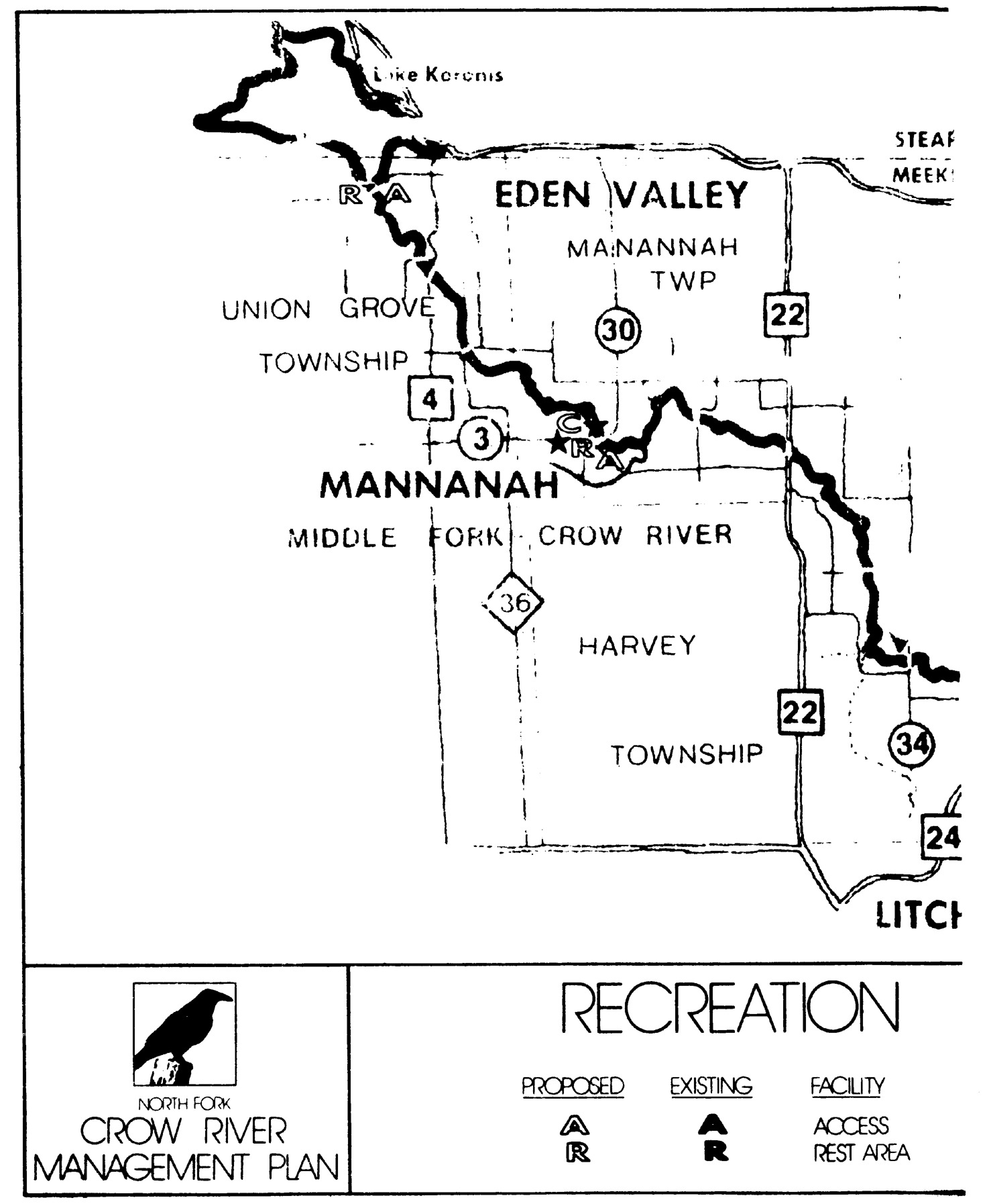
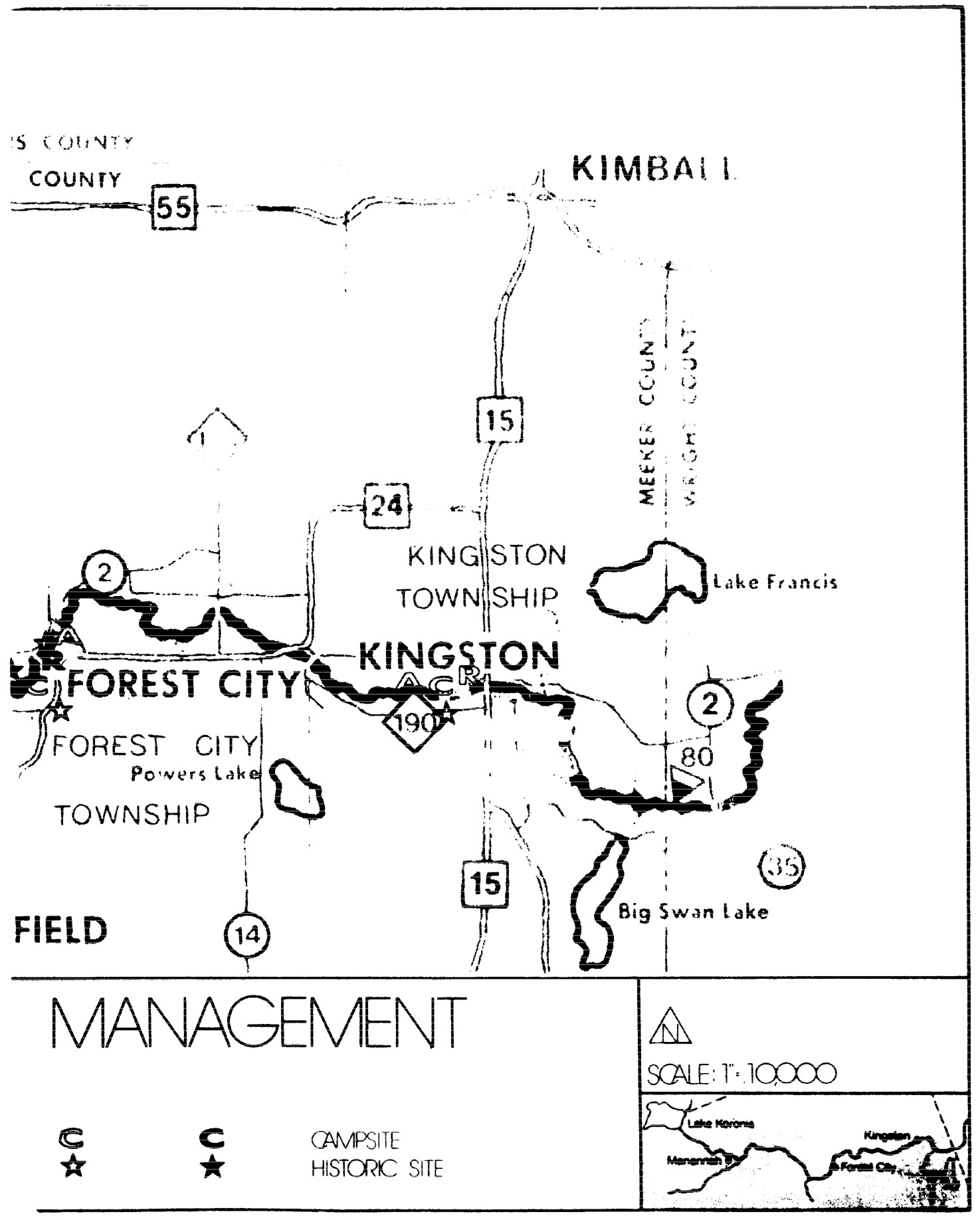
Statutory Authority:
MS s 104.35
Published Electronically:
June 11, 2008
6105.1130 SITES TYPICAL.
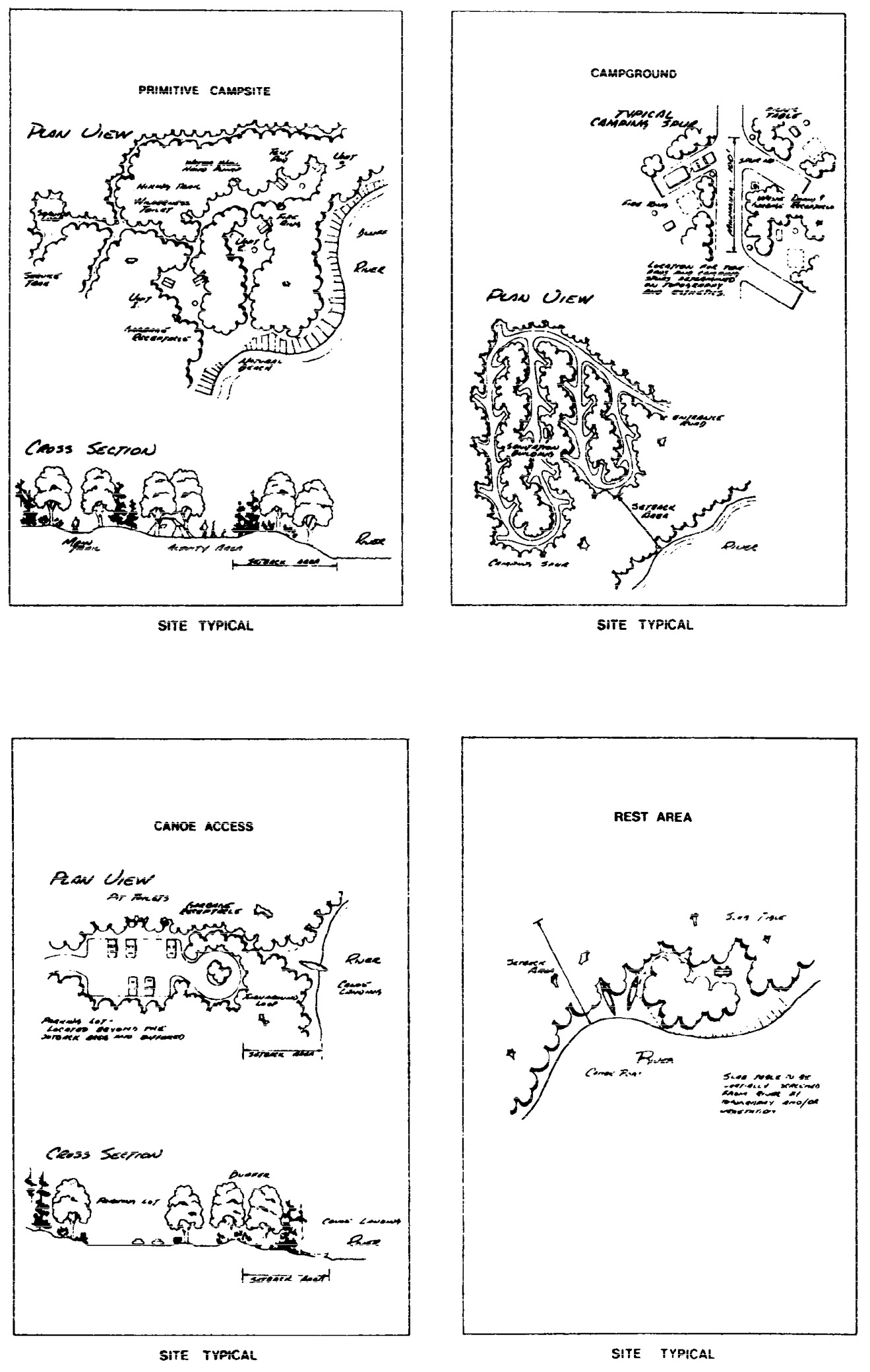
Statutory Authority:
MS s 104.35
Published Electronically:
June 11, 2008
MINNESOTA RIVER MANAGEMENT PLAN
6105.1200 DESIGNATION OF RIVER.
That portion of the Minnesota River from the Lac qui Parle Dam to the Redwood County State-Aid Highway 11 bridge near Franklin is designated a component of the Minnesota wild and scenic rivers system.
Statutory Authority:
MS s 104.35
Published Electronically:
June 11, 2008
6105.1210 STATUTORY AUTHORITY.
This designation is made by the commissioner of natural resources pursuant to the authority of the Minnesota Wild and Scenic Rivers Act, Minnesota Statutes 1974, sections 104.31 to 104.40.
Statutory Authority:
MS s 104.35
Published Electronically:
June 11, 2008
6105.1220 SCOPE.
The designation and parts 6105.1200 to 6105.1370 apply to the river and the adjacent lands indicated by the land use district descriptions. The land use district boundaries were delineated in accordance with part 6105.0070, subpart 2, item B.
Statutory Authority:
MS s 104.35
Published Electronically:
June 11, 2008
6105.1230 SEVERABILITY.
The provisions of these rules shall be severable, and the invalidity of any paragraph, subparagraph, or subdivision thereof shall not make void any other paragraph, subparagraph, subdivision, or any other part.
Statutory Authority:
MS s 104.35
Published Electronically:
June 11, 2008
6105.1240 STIPULATION.
The commissioner of the Department of Natural Resources will not request the inclusion of that portion of the Minnesota River from the Lac qui Parle Dam to the Redwood County State-Aid Highway 11 bridge near Franklin into the federal wild and scenic rivers system without the consent of the county board of commissioners of Lac qui Parle, Chippewa, Yellow Medicine, Redwood, and Renville Counties.
Statutory Authority:
MS s 104.35
Published Electronically:
October 8, 2013
6105.1250 RIVER CLASSIFICATIONS.
River classifications:
A.
That portion of the Minnesota River and adjacent lands from the Lac qui Parle Dam to the U.S. Highway 212 bridge in the corporate limits of Montevideo is classified as scenic.
B.
That portion of the Minnesota River and adjacent lands from the U.S. Highway 212 bridge in the corporate limits of Montevideo to the Great Lakes Pipeline one-quarter mile downstream of the Minnesota Falls Dam is classified as recreational.
C.
That portion of the Minnesota River and adjacent lands from the Great Lakes Pipeline one-quarter mile downstream of the Minnesota Falls Dam to the Redwood County State-Aid Highway 11 bridge is classified as scenic.
These classifications are made in accordance with the provisions of Minnesota Statutes, sections 103F.311, subdivisions 3, 4, 7, and 9, and 103F.315, subdivision 2; and part 6105.0060.
Published Electronically:
June 11, 2008
6105.1260 LAND MANAGEMENT; ZONING.
Subpart 1.
County ordinances.
The counties of Lac qui Parle, Chippewa, Yellow Medicine, Renville, and Redwood shall each enact or amend such ordinances and maps as necessary to:
Subp. 2.
Municipality ordinances.
The municipalities of Montevideo, Granite Falls, North Redwood, and Morton shall enact or amend such ordinances and maps as necessary to:
A.
establish scenic and recreational river land use districts as applicable according to part 6105.1250 to include the lands identified by the land use district descriptions;
Subp. 3.
Transferred land.
If land is annexed, incorporated, or in any other way transferred to another jurisdiction, a moratorium shall exist on all construction, grading and filling, and vegetative cutting until the newly responsible unit of government adopts zoning for that land. The zoning shall meet the provisions of this management plan which applied to the land before the transfer. This provision does not apply to work for which lawful permits were previously issued.
Subp. 4.
More protective rules.
All local ordinances and regulations which are more protective than those required to be adopted by this management plan may be continued.
Statutory Authority:
MS s 104.35
Published Electronically:
June 11, 2008
6105.1270 LAND ACQUISITION.
Subpart 1.
Acquisition funds.
The lands or interests in land recommended to be acquired in this plan will be acquired when funds are available for such purchases from willing sellers, as provided for in Minnesota Statutes 1974, section 104.37.
A.
Fee title acquisition is recommended in those areas where recreational sites are needed. These areas are identified in the fee title descriptions.
B.
Scenic easement acquisition is recommended in those areas having outstanding scenic or natural characteristics as identified in the scenic easement descriptions.
C.
Because fee title acquisition or scenic easement acquisition is from willing sellers at the appraised market value, some lands recommended for scenic easement acquisition may be purchased in fee title. Some lands recommended for fee title acquisition may be purchased in scenic easement. This change from the recommended acquisition would be based on the mutual agreement by and between the state of Minnesota and the landowner(s).
Subp. 2.
Other forms of acquisition.
Other forms of acquisition, such as use easements or leases, may be used to acquire interests in lands within the land use districts.
Subp. 3.
Land exchange.
Land will be exchanged, whenever feasible, to acquire lands within the land use districts. These exchanges will be done in the manner prescribed by state law. However, land exchanges will not be recommended if such exchanges would adversely affect this or any other Department of Natural Resources management program.
Subp. 4.
Additional lands or interests.
Additional lands or interests in land may be purchased within the land use districts from willing sellers to further the policies established in Minnesota Statutes, section 103F.305, and this management plan.
Subp. 5.
Eminent domain authority.
Land acquisition authority contained in this subpart is promulgated under Minnesota Statutes 1974, section 104.37, which does not give the commissioner of the Department of Natural Resources eminent domain authority within the river land use districts. If in the future, eminent domain authority is granted as a method of land acquisition under Minnesota Statutes, section 103F.331, it shall not be utilized in the river land use districts without explicit repromulgation or amendment of this rule. This provision does not apply when the commissioner of the Department of Natural Resources is ordered by the legislature to use eminent domain authority within the river land use districts.
Published Electronically:
June 11, 2008
6105.1280 RECREATION MANAGEMENT.
Subpart 1.
Policy.
Recreation management in the scenic and recreational river land use districts shall conform to the policies and provisions of part 6105.0210.
Subp. 2.
Design specifications.
As provided for in part 6105.0100 and the management plan, the development of public or private recreational facilities within the scenic and recreational river land use districts shall conform to the design specification guidelines as shown on the recreational site typicals with the addition of a gate to the service trail for primitive campsites.
Subp. 3.
Camping.
No Department of Natural Resources river-oriented camping facilities will be provided close to private river-oriented camping facilities which are designed to serve the same needs.
Subp. 4.
Regulated use.
The recreational use of the Minnesota scenic and recreational river and adjacent public lands will be regulated where necessary to ensure that the use does not adversely affect the values which qualified the river for designation.
Subp. 5.
Snowmobiling.
Snowmobiling in the land use district will be allowed: on private lands only with permission from appropriate landowners; on trails specifically designated for snowmobiling in state parks, or designated by local governments or the legislature.
Subp. 6.
Purchase of land.
On areas which are not presently publicly owned, some type of land interest must be purchased before lands are available for public use.
Subp. 7.
Funds.
The Division of Parks and Recreation shall allocate funds for the maintenance of Department of Natural Resources recreational facilities within the Minnesota River land use districts from the department's river development and maintenance account.
Subp. 8.
Priority areas for recreational development.
Priority areas for recreational development are shown:
Subp. 9.
Distribution of responsibilities.
The department's Enforcement Division shall enter into discussions with the local units of government concerning the delineation of responsibilities for the enforcement of applicable wild, scenic, and recreational river regulations. The Enforcement Division shall extend sufficient effort to meet enforcement responsibilities in the Minnesota River land use districts.
Statutory Authority:
MS s 104.35
Published Electronically:
June 11, 2008
6105.1290 LAND USE DISTRICT DESCRIPTIONS AND ACREAGES.
Subpart 1.
General.
All acreages shown in the land use district section are from the original government survey. Because of certain apparent deficiencies in the survey, a grid system was used to ensure that no river mile exceeds 320 acres.
The following abbreviations are used in the land use descriptions in subparts 2 to 18.
Subp. 2.
T 118 N - R 42 W.
The land use district descriptions and acreages for T 118 N - R 42 W are as follows:
| A. | Section 24 | |||
| Government Lot 1 | (LQP) | all but W 20 | 12.50 | |
| Government Lot 2 | (LQP) | 37.25 | ||
| Government Lot 3 | (LQP) | 28.70 | ||
| Government Lot 4 | (LQP) | 47.90 | ||
| Government Lot 1 | (C) | 33.25 | ||
| Government Lot 2 | (C) | 22.80 | ||
| Government Lot 3 | (C) | 6.90 | ||
| Government Lot 4 | (C) | 36.40 | ||
| Government Lot 5 | (C) | 17.75 | ||
| NE 1/4 of SW 1/4 | 40.00 | |||
| SE 1/4 of NE 1/4 | 40.00 | |||
| B. | Section 25 | |||
| Government Lot 1 | (LQP) | 38.75 | ||
| Government Lot 1 | (C) | 1.00 | ||
| E 1/2 of NW 1/4 of NE 1/4 | 20.00 | |||
| SE 1/4 of NE 1/4 | 40.00 |
Subp. 3.
T 118 N - R 41 W.
The land use district descriptions and acreages for T 118 N - R 41 W are as follows:
| A. | Section 19 | |||
| SW 1/4 of SW 1/4 | 34.19 | |||
| SE 1/4 of SW 1/4 | 40.00 | |||
| W 1/2 of NW 1/4 of SW 1/4 | 20.00 | |||
| B. | Section 30 | |||
| Government Lot 1 | (C) | 14.85 | ||
| Government Lot 2 | (C) | 36.00 | ||
| Government Lot 3 | (C) | 60.00 | ||
| Government Lot 4 | (C) | 59.25 | ||
| Government Lot 6 | (LQP) | 20.35 | ||
| Government Lot 5 | (LQP) | 38.75 | ||
| Government Lot 4 | (LQP) | 49.50 | ||
| Government Lot 3 | (LQP) | 53.90 | ||
| SW 1/4 of NW 1/4 | 40.00 | |||
| W 1/2 of NE 1/4 of NE 1/4 | 20.00 | |||
| E 1/2 of NE 1/4 of SW 1/4 | 20.00 | |||
| C. | Section 29 | |||
| Government Lot 1 | (C) | 31.25 | ||
| Government Lot 2 | (C) | 36.05 | ||
| Government Lot 3 | (C) | 37.75 | ||
| Government Lot 1 | (LQP) | 13.20 | ||
| W 1/2 of SW 1/4 of NW 1/4 | 20.00 | |||
| SW 1/4 of SE 1/4 | 40.00 | |||
| D. | Section 32 | |||
| Government Lot 1 | (LQP) | 39.45 | ||
| Government Lot 2 | (LQP) | 48.00 | ||
| Government Lot 3 | (LQP) | 28.80 | ||
| Government Lot 4 | (LQP) | 31.00 | ||
| Government Lot 5 | (LQP) | 32.00 | ||
| Government Lot 2 | (C) | 43.35 | ||
| Government Lot 3 | (C) | 43.50 | ||
| Government Lot 4 | (C) | 45.75 | ||
| SE 1/4 of NE 1/4 | 40.00 | |||
| Government Lot 1 | (C) | 15.00 |
Subp. 4.
T 117 N - R 41 W.
The land use district descriptions and acreages for T 117 N - R 41 W are as follows:
| A. | Section 5 | |||
| Government Lot 1 | (LQP) | 41.56 | ||
| Government Lot 2 | (LQP) | 45.60 | ||
| Government Lot 3 | (LQP) | 48.25 | ||
| Government Lot 4 | (LQP) | 52.50 | ||
| Government Lot 1 | (C) | 41.25 | ||
| Government Lot 2 | (C) | 41.60 | ||
| Government Lot 3 | (C) | 30.50 | ||
| Government Lot 4 | (C) | 30.60 | ||
| B. | Section 4 | |||
| W 1/2 of NW 1/4 of NW 1/4 | 20.00 | |||
| SW 1/4 of NW 1/4 | 40.00 | |||
| NW 1/4 of SW 1/4 | 40.00 | |||
| SW 1/4 of SW 1/4 | 40.00 | |||
| SE 1/4 of SW 1/4 | 40.00 | |||
| C. | Section 8 | |||
| Government Lot 1 | (LQP) | 18.75 | ||
| Government Lot 2 | (LQP) | 39.55 | ||
| Government Lot 1 | (C) | 18.20 | ||
| NW 1/4 of NE 1/4 | 40.00 | |||
| SW 1/4 of NE 1/4 | 40.00 | |||
| D. | Section 9 | |||
| Government Lot 1 | (C) | 30.30 | ||
| Government Lot 2 | (C) | 42.25 | ||
| Government Lot 3 | (C) | 39.99 | ||
| Government Lot 4 | (C) | 41.05 | ||
| Government Lot 4 | (LQP) | 36.80 | ||
| Government Lot 3 | (LQP) | 32.25 | ||
| Government Lot 2 | (LQP) | 35.75 | ||
| Government Lot 1 | (LQP) | 41.60 | ||
| NW 1/4 of SW 1/4 | 40.00 | |||
| W 1/2 of NW 1/4 of NE 1/4 | 20.00 | |||
| Government Lot 5 | (C) | 58.10 | ||
| SW 1/4 of SW 1/4 | 40.00 | |||
| E. | Section 16 | |||
| Government Lot 2 | (LQP) | 39.99 | ||
| Government Lot 1 | (LQP) | 31.25 | ||
| Government Lot 1 | (C) | 12.60 | ||
| NE 1/4 of NW 1/4 | 40.00 | |||
| SE 1/4 of NE 1/4 | 40.00 | |||
| F. | Section 10 | |||
| SW 1/4 of SW 1/4 | 40.00 | |||
| SE 1/4 of SW 1/4 | 40.00 | |||
| S 1/2 of SW 1/4 of SE 1/4 | 20.00 | |||
| S 1/2 of SE 1/4 of SE 1/4 | 20.00 | |||
| G. | Section 15 | |||
| Government Lot 7 | (LQP) | 45.95 | ||
| Government Lot 8 | (LQP) | 16.60 | ||
| Government Lot 3 | (LQP) | 39.99 | ||
| Government Lot 2 | (LQP) | 17.50 | ||
| Government Lot 1 | (LQP) | 26.40 | ||
| Government Lot 1 | (C) | 34.75 | ||
| Government Lot 2 | (C) | 15.00 | ||
| Government Lot 3 | (C) | 40.00 | ||
| H. | Section 11 | |||
| S 1/2 of SE 1/4 of SW 1/4 | 20.00 | |||
| S 1/2 of SW 1/4 of SE 1/4 | 20.00 | |||
| I. | Section 14 | |||
| Government Lot 4 | (LQP) | 23.75 | ||
| Government Lot 3 | (LQP) | all but S 40 | 19.50 | |
| Government Lot 2 | (LQP) | 47.20 | ||
| Government Lot 1 | (LQP) | 50.25 | ||
| Government Lot 1 | (C) | 49.25 | ||
| Government Lot 2 | (C) | 26.55 | ||
| Government Lot 3 | (C) | 35.00 | ||
| Government Lot 4 | (C) | 41.15 | ||
| Government Lot 5 | (C) | 36.60 | ||
| S 1/2 of NW 1/4 of NW 1/4 | 20.00 | |||
| SE 1/4 of SE 1/4 | 40.00 | |||
| J. | Section 13 | |||
| Government Lot 1 | (C) | 7.50 | ||
| Government Lot 4 | (LQP) | 49.00 | ||
| Government Lot 3 | (LQP) | 45.15 | ||
| Government Lot 2 | (LQP) | 26.20 | ||
| Government Lot 1 | (LQP) | 22.50 | ||
| Government Lot 2 | (C) | 35.10 | ||
| Government Lot 3 | (C) | 33.65 | ||
| Government Lot 4 | (C) | 17.20 | ||
| Government Lot 5 | (C) | 58.10 | ||
| NE 1/4 of NW 1/4 | 40.00 | |||
| NW 1/4 of NE 1/4 | 40.00 | |||
| SE 1/4 of NE 1/4 | 40.00 |
Subp. 5.
T 117 N - R 40 W.
The land use district descriptions and acreages for T 117 N - R 40 W are as follows:
| A. | Section 18 | |||
| Government Lot 4 | (C) | a line 300 feet from the normal high-water mark | 7.00 | |
| Government Lot 1 | (YM) | 1.75 | ||
| B. | Section 19 | |||
| Government Lot 1 | (YM) | 38.35 | ||
| Government Lot 3 | (YM) | 37.95 | ||
| Government Lot 4 | (YM) | 22.40 | ||
| Government Lot 5 | (YM) | 44.75 | ||
| Government Lot 1 | (C) | a line 300 feet from the normal high-water mark | 11.00 | |
| Government Lot 2 | (C) | 33.75 | ||
| Government Lot 3 | (C) | 50.00 | ||
| Government Lot 4 | (C) | 24.80 | ||
| SE 1/4 of NE 1/4 | 40.00 | |||
| E 1/2 of NE 1/4 of SW 1/4 | 20.00 | |||
| C. | Section 20 | |||
| W 1/2 of NW 1/4 of SW 1/4 | 20.00 | |||
| W 1/2 of SW 1/4 of SW 1/4 | 20.00 | |||
| D. | Section 30 | |||
| Government Lot 3 | (YM) | 35.90 | ||
| Government Lot 4 | (YM) | 35.40 | ||
| Government Lot 5 | (YM) | 27.40 | ||
| Government Lot 1 | (C) | 27.70 | ||
| Government Lot 2 | (C) | 20.40 | ||
| Government Lot 3 | (C) | 49.00 | ||
| Government Lot 6 | (YM) | 37.43 | ||
| E. | Section 29 | |||
| NW 1/4 of SW 1/4 | 40.00 | |||
| NW 1/4 of NW 1/4 | 40.00 | |||
| SW 1/4 of NW 1/4 | 40.00 | |||
| Government Lot 1 | (C) | 31.80 | ||
| Government Lot 2 | (C) | 39.75 | ||
| SW 1/4 of SE 1/4 | 40.00 | |||
| S 1/2 of SE 1/4 of SE 1/4 | 20.00 | |||
| F. | Section 31 | |||
| Government Lot 3 | (YM) | 39.40 | ||
| E 1/2 of NW 1/4 of NE 1/4 | 20.00 | |||
| G. | Section 32 | |||
| Government Lot 1 | (C) | 26.40 | ||
| Government Lot 2 | (C) | 12.70 | ||
| Government Lot 2 | (YM) | all but S 20 | 34.40 | |
| Government Lot 3 | (YM) | all but S 20 | 31.90 | |
| Government Lot 4 | (YM) | all but S 20 | 34.95 | |
| Government Lot 1 | (YM) | 34.25 | ||
| H. | Section 33 | |||
| Government Lot 1 | (C) | 19.70 | ||
| Government Lot 2 | (C) | 38.75 | ||
| Government Lot 1 | (YM) | all but S 20 | 26.75 | |
| Government Lot 2 | (YM) | 39.73 | ||
| Government Lot 3 | (YM) | 26.20 | ||
| Government Lot 4 | (YM) | all but S 20 | 19.10 | |
| I. | Section 28 | |||
| S 1/2 of SW 1/4 of SW 1/4 | 20.00 | |||
| SE 1/4 of SW 1/4 | all but NW 1/4 | 30.00 | ||
| Government Lot 1 | (C) | 30.00 | ||
| Government Lot 2 | (C) | 35.75 | ||
| Government Lot 3 | (C) | all but the NE 10 | 39.50 | |
| Government Lot 1 | (YM) | 5.43 | ||
| J. | Section 27 | |||
| Government Lot 1 | (C) | 38.35 | ||
| K. | Section 34 | |||
| Government Lot 1 | (C) | 48.75 | ||
| Government Lot 2 | (C) | 42.60 | ||
| Government Lot 3 | (C) | 39.80 | ||
| Government Lot 4 | (C) | 39.80 | ||
| Government Lot 5 | (C) | 58.75 | ||
| Government Lot 1 | (YM) | 33.30 | ||
| Government Lot 2 | (YM) | 21.55 | ||
| Government Lot 3 | (YM) | 59.57 | ||
| N 1/2 of SW 1/4 of SW 1/4 | 20.00 | |||
| L. | Section 35 | |||
| Government Lot 1 | (YM) | 39.50 | ||
| Government Lot 2 | (YM) | 39.95 |
Subp. 6.
T 116 N - R 40 W.
The land use district descriptions and acreages for T 116 N - R 40 W are as follows:
| A. | Section 3 | |||
| Government Lot 3 | (YM) | 27.61 | ||
| Government Lot 2 | (YM) | 51.00 | ||
| Government Lot 1 | (YM) | 32.45 | ||
| Government Lot 1 | (C) | 21.65 | ||
| Government Lot 2 | (C) | everything W of CSAH 15 | 21.19 | |
| Government Lot 3 | (C) | 50.40 | ||
| Government Lot 4 | (C) | 43.05 | ||
| Government Lot 4 | (YM) | 20.25 | ||
| Government Lot 5 | (YM) | 22.85 | ||
| E 1/2 of NE 1/4 of SW 1/4 | 20.00 | |||
| E 1/2 of SW 1/4 of SE 1/4 | 20.00 | |||
| B. | Section 10 | |||
| Government Lot 1 | (YM) | 39.30 | ||
| C. | Section 2 | |||
| Government Lot 5 | (C) | 36.75 | ||
| Government Lot 6 | (C) | 30.00 | ||
| SE 1/4 of SW 1/4 | 40.00 | |||
| SE 1/4 of SE 1/4 | 40.00 | |||
| D. | Section 11 | |||
| Government Lot 1 | (C) | 34.70 | ||
| Government Lot 2 | (C) | 40.10 | ||
| Government Lot 3 | (C) | 23.00 | ||
| Government Lot 1 | (YM) | all but the S 40 | 10.25 | |
| Government Lot 2 | (YM) | 39.45 | ||
| Government Lot 3 | (YM) | 25.80 | ||
| Government Lot 4 | (YM) | 22.00 | ||
| Government Lot 5 | (YM) | 34.00 | ||
| Government Lot 6 | (YM) | 49.20 | ||
| E. | Section 12 | |||
| Government Lot 1 | (YM) | 35.00 | ||
| Government Lot 1 | (C) | 14.00 | ||
| Government Lot 2 | (C) | 38.00 | ||
| Government Lot 3 | (C) | 17.15 | ||
| W 1/2 of SW 1/4 of SE 1/4 | 20.00 | |||
| S 1/2 of SW 1/4 of NW 1/4 | 20.00 | |||
| F. | Section 13 | |||
| Government Lot 1 | (C) | 38.75 | ||
| Government Lot 2 | (C) | 41.50 | ||
| Government Lot 1 | (YM) | 27.55 | ||
| Government Lot 2 | (YM) | 29.90 | ||
| SE 1/4 of NE 1/4 | 40.00 | |||
| Government Lot 3 | (YM) | 24.10 | ||
| Government Lot 4 | (YM) | 37.90 | ||
| Government Lot 5 | (YM) | 17.30 | ||
| Government Lot 6 | (YM) | 19.75 | ||
| Government Lot 3 | (C) | 62.15 | ||
| Government Lot 4 | (C) | 54.15 |
Subp. 7.
T 116 N - R 39 W.
The land use district descriptions and acreages for T 116 N - R 39 W are as follows:
| A. | Section 18 | |||
| Government Lot 3 | (C) | 27.00 | ||
| Government Lot 4 | (C) | 14.00 | ||
| Government Lot 1 | (YM) | 36.88 | ||
| NE 1/4 of SW 1/4 | 40.00 | |||
| SW 1/4 of SE 1/4 | 40.00 | |||
| W 1/2 of NW 1/4 of SE 1/4 | 20.00 | |||
| B. | Section 19 | |||
| Government Lot 1 | (C) | 55.25 | ||
| Government Lot 2 | (C) | 40.50 | ||
| Government Lot 3 | (C) | 32.40 | ||
| Government Lot 1 | (YM) | 30.75 | ||
| Government Lot 2 | (YM) | 37.00 | ||
| Government Lot 3 | (YM) | all but S 10 | 22.70 | |
| Government Lot 5 | (YM) | all but S 20 | 30.50 | |
| Government Lot 6 | (YM) | all but S 20 | 23.65 | |
| Government Lot 7 | (YM) | 36.15 |
Subp. 8.
T 116 N - R 39 W.
The land use district descriptions and acreages for T 116 N - R 39 W are as follows:
| A. | Section 20 | |||
| Government Lot 1 | (C) | 33.80 | ||
| Government Lot 2 | (C) | 27.00 | ||
| Government Lot 3 | (C) | 34.60 | ||
| Government Lot 4 | (C) | 49.55 | ||
| Government Lot 5 | (C) | 24.00 | ||
| Government Lot 1 | (YM) | 40.50 | ||
| Government Lot 2 | (YM) | all but SW 20 | 27.74 | |
| B. | Section 21 | |||
| Government Lot 1 | (C) | all but E 20 | 19.60 | |
| C. | Section 28 | |||
| Government Lot 1 | (C) | all but E 20 | 18.60 | |
| Government Lot 2 | (C) | 37.00 | ||
| Government Lot 3 | (C) | 30.00 | ||
| Government Lot 4 | (C) | 42.00 | ||
| Government Lot 5 | (C) | 21.75 | ||
| Government Lot 1 | (YM) | all but S 30 | 23.10 | |
| Government Lot 2 | (YM) | 26.35 | ||
| Government Lot 3 | (YM) | 16.70 | ||
| D. | Section 27 | |||
| Government Lot 1 | (C) | a line 300 feet from the normal high-water mark | 13.10 | |
| E. | Section 29 | |||
| Government Lot 1 | (C) | 27.45 | ||
| Government Lot 1 | (YM) | all but W 20 | 19.60 | |
| Government Lot 2 | (YM) | all but W 20 | 18.25 | |
| Government Lot 3 | (YM) | all but SW 20 | 24.25 | |
| F. | Section 34 | |||
| Government Lot 1 | (C) | a line 300 feet from the normal high-water mark | 13.25 | |
| Government Lot 2 | (C) | a line 300 feet from the normal high-water mark | 11.00 | |
| Government Lot 3 | (C) | a line 300 feet from the normal high-water mark | 12.80 | |
| Government Lot 4 | (C) | a line 300 feet from the normal high-water mark | 4.00 | |
| Government Lot 5 | (C) | a line 300 feet from the normal high-water mark | 9.00 | |
| Government Lot 1 | (YM) | a line 300 feet from the normal high-water mark | 3.00 | |
| Government Lot 2 | (YM) | a line 300 feet from the normal high-water mark | 15.00 | |
| Government Lot 3 | (YM) | a line 300 feet from the normal high-water mark | 8.00 | |
| G. | Section 33 | |||
| Government Lot 1 | (YM) | a line 300 feet from the normal high-water mark | 7.00 | |
| Government Lot 2 | (YM) | a line 300 feet from the normal high-water mark | 9.00 |
Subp. 9.
T 115 N - R 39 W.
The land use district descriptions and acreages for T 115 N - R 39 W are as follows:
| A. | Section 4 | |||
| Government Lot 3 | (YM) | everything east of State Hwy. 23 | 18.10 | |
| B. | Section 3 | |||
| Government Lot 4 | (C) | 8.60 | ||
| Government Lot 3 | (C) | a line 300 feet from the normal high-water mark | 9.00 | |
| Government Lot 2 | (C) | a line 300 feet from the normal high-water mark | 9.00 | |
| Government Lot 1 | (C) | a line 300 feet from the normal high-water mark | 10.00 | |
| N 1/2 of SE 1/4 of NW 1/4 | 20.00 | |||
| N 1/2 of SW 1/4 of NE 1/4 | 20.00 | |||
| Government Lot 2 | (YM) | 37.12 | ||
| Government Lot 3 | (YM) | 38.32 | ||
| Government Lot 4 | (YM) | 34.00 | ||
| Government Lot 5 | (YM) | all but S 20 | 38.00 | |
| SW 1/4 of NW 1/4 | 40.00 | |||
| C. | Section 2 | |||
| Government Lot 4 | (C) | 17.15 | ||
| Government Lot 3 | (C) | 41.25 | ||
| Government Lot 2 | (C) | 29.70 | ||
| Government Lot 1 | (C) | all but N 20 | 32.00 | |
| Government Lot 1 | (YM) | all but S 20 | 27.25 | |
| Government Lot 2 | (YM) | 26.00 | ||
| Government Lot 3 | (YM) | 25.40 | ||
| Government Lot 4 | (YM) | 37.50 | ||
| N 1/2 of NE 1/4 of SW 1/4 | 20.00 | |||
| SE 1/4 of NE 1/4 of SW 1/4 | 10.00 | |||
| SW 1/4 of SE 1/4 | 40.00 | |||
| D. | Section 1 | |||
| Government Lot 5 | (C) | 37.25 | ||
| Government Lot 6 | (C) | 35.25 | ||
| Government Lot 1 | (YM) | 16.10 | ||
| E. | Section 12 | |||
| Government Lot 1 | (C) | 35.50 | ||
| Government Lot 2 | (C) | 46.25 | ||
| Government Lot 1 | (YM) | 22.96 | ||
| W 1/2 of SE 1/4 of NW 1/4 | 20.00 | |||
| F. | Section 11 | |||
| S 1/2 of NW 1/4 of NW 1/4 | 20.00 | |||
| S 1/2 of NE 1/4 of NW 1/4 | 20.00 | |||
| NW 1/4 of NE 1/4 | 40.00 | |||
| Government Lot 1 | (C) | 35.30 | ||
| Government Lot 2 | (C) | 18.75 | ||
| Government Lot 3 | (C) | all but S 20 | 33.30 | |
| Government Lot 4 | (C) | 52.25 | ||
| Government Lot 5 | (C) | 30.15 | ||
| Government Lot 1 | (YM) | 50.57 | ||
| Government Lot 2 | (YM) | 25.07 | ||
| Government Lot 3 | (YM) | 22.65 | ||
| Government Lot 4 | (YM) | 21.42 | ||
| G. | Section 10 | |||
| Government Lot 3 | (C) | 0.60 | ||
| Government Lot 1 | (C) | 9.60 | ||
| Government Lot 2 | (C) | 1.20 | ||
| Government Lot 1 | (YM) | 34.00 | ||
| Government Lot 2 | (YM) | 30.15 | ||
| Government Lot 3 | (YM) | 59.15 | ||
| H. | Section 15 | |||
| Government Lot 1 | (C) | 55.30 | ||
| Government Lot 1 | (YM) | 49.85 | ||
| SW 1/4 of NE 1/4 | 40.00 | |||
| I. | Section 14 | |||
| Government Lot 4 | (C) | 37.70 | ||
| Government Lot 3 | (C) | 29.30 | ||
| Government Lot 2 | (C) | 39.10 | ||
| Government Lot 5 | (C) | 57.75 | ||
| Government Lot 1 | (C) | 18.70 | ||
| J. | Section 13 | |||
| Government Lot 2 | (C) | 43.10 | ||
| Government Lot 3 | (C) | 39.55 | ||
| Government Lot 4 | (C) | all but E 20 | 41.25 | |
| Government Lot 5 | (C) | all but E 20 | 40.25 | |
| Government Lot 1 | (C) | 26.25 | ||
| Government Lot 1 | (YM) | all but portion in Indian reservation | 7.00 | |
| Government Lot 2 | (YM) | all but W 10 | 13.82 | |
| Government Lot 3 | (YM) | all but W 10 | 25.35 | |
| K. | Section 24 | |||
| Government Lot 1 | (C) | 25.25 | ||
| Government Lot 2 | (C) | 28.25 | ||
| Government Lot 3 | (C) | 46.50 | ||
| Government Lot 1 | (YM) | 43.85 | ||
| Government Lot 2 | (YM) | 48.75 | ||
| Government Lot 3 | (YM) | 21.43 | ||
| Government Lot 4 | (YM) | 21.60 | ||
| NE 1/4 of NE 1/4 | 40.00 |
Subp. 10.
T 115 N - R 38 W.
The land use district descriptions and acreages for T 115 N - R 38 W are as follows:
| A. | Section 20 | |||
| W 1/2 of NW 1/4 of SW 1/4 | 20.00 | |||
| Government Lot 1 | (REN) | all but E 20 | 19.80 | |
| B. | Section 19 | |||
| SW 1/4 of NW 1/4 of NE 1/4 | 10.00 | |||
| Government Lot 4 | (YM) | 42.81 | ||
| Government Lot 3 | (YM) | 56.43 | ||
| Government Lot 2 | (YM) | 50.64 | ||
| Government Lot 1 | (YM) | 31.73 | ||
| Government Lot 1 | (REN) | 51.30 | ||
| Government Lot 2 | (REN) | 41.35 | ||
| Government Lot 3 | (REN) | 32.00 | ||
| Government Lot 4 | (REN) | 44.10 | ||
| Government Lot 5 | (REN) | .85 | ||
| N 1/2 of SW 1/4 of SE 1/4 | 20.00 | |||
| C. | Section 30 | |||
| Government Lot 3 | (YM) | 34.75 | ||
| Government Lot 1 | (REN) | .05 | ||
| D. | Section 29 | |||
| Government Lot 1 | (YM) | 34.75 | ||
| Government Lot 2 | (YM) | 29.66 | ||
| Government Lot 3 | (YM) | 44.67 | ||
| Government Lot 4 | (YM) | 51.85 | ||
| Government Lot 4 | (REN) | 18.85 | ||
| Government Lot 3 | (REN) | all but N 20 | 20.75 | |
| Government Lot 2 | (REN) | 30.50 | ||
| Government Lot 1 | (REN) | 17.00 | ||
| E. | Section 28 | |||
| Government Lot 1 | (YM) | 31.68 | ||
| Government Lot 2 | (YM) | 47.94 | ||
| Government Lot 3 | (YM) | 51.06 | ||
| Government Lot 4 | (YM) | 24.46 | ||
| Government Lot 5 | (REN) | 20.40 | ||
| Government Lot 4 | (REN) | 47.85 | ||
| Government Lot 3 | (REN) | all but N 20 | 41.20 | |
| Government Lot 2 | (REN) | 39.00 | ||
| Government Lot 1 | (REN) | 14.00 | ||
| F. | Section 27 | |||
| Government Lot 1 | (YM) | 40.69 | ||
| Government Lot 2 | (YM) | 63.81 | ||
| Government Lot 3 | (REN) | 51.40 | ||
| Government Lot 2 | (REN) | 44.10 | ||
| Government Lot 1 | (REN) | 29.75 | ||
| SE 1/4 of SE 1/4 | 40.00 | |||
| G. | Section 33 | |||
| N 1/2 of NE 1/4 of NE 1/4 | 20.00 | |||
| H. | Section 34 | |||
| Government Lot 1 | (YM) | 26.93 | ||
| Government Lot 3 | (YM) | 32.63 | ||
| Government Lot 1 | (REN) | 32.70 | ||
| N 1/2 of NW 1/4 of NW 1/4 | 20.00 | |||
| NE 1/4 of SE 1/4 | 40.00 | |||
| N 1/2 of NE 1/4 of NW 1/4 | 20.00 | |||
| SE 1/4 of SE 1/4 | 40.00 | |||
| I. | Section 35 | |||
| Government Lot 1 | (YM) | 16.55 | ||
| Government Lot 2 | (YM) | 22.64 | ||
| Government Lot 1 | (REN) | 24.00 | ||
| Government Lot 2 | (REN) | 56.50 | ||
| Government Lot 3 | (REN) | 38.65 | ||
| Government Lot 4 | (REN) | 25.60 | ||
| Government Lot 5 | (REN) | 19.50 | ||
| Government Lot 6 | (REN) | 22.05 | ||
| S 1/2 of NW 1/4 of NW 1/4 | 20.00 | |||
| W 1/2 of SE 1/4 of NW 1/4 | 20.00 |
Subp. 11.
T 114 N - R 38 W.
The land use district descriptions and acreages for T 114 N - R 38 W are as follows:
| A. | Section 2 | |||
| Government Lot 1 | (YM) | 32.46 | ||
| Government Lot 2 | (YM) | 51.15 | ||
| Government Lot 3 | (YM) | 12.37 | ||
| Government Lot 4 | (YM) | all but W 20 | 10.40 | |
| Government Lot 6 | (YM) | 29.75 | ||
| Government Lot 4 | (REN) | 31.25 | ||
| Government Lot 3 | (REN) | 59.20 | ||
| Government Lot 2 | (REN) | 56.50 | ||
| Government Lot 1 | (REN) | 5.00 | ||
| N 1/2 of SW 1/4 of NW 1/4 | 20.00 | |||
| B. | Section 1 | |||
| S 1/2 of SE 1/4 of SE 1/4 | 20.00 | |||
| Government Lot 1 | (YM) | 12.34 | ||
| Government Lot 5 | (REN) | 35.00 | ||
| Government Lot 6 | (REN) | 52.50 | ||
| Government Lot 7 | (REN) | 35.50 | ||
| S 1/2 of NW 1/4 of NW 1/4 | 20.00 | |||
| SW 1/4 of SE 1/4 | 40.00 | |||
| C. | Section 12 | |||
| Government Lot 1 | (YM) | 32.60 | ||
| Government Lot 2 | (YM) | 23.92 | ||
| Government Lot 3 | (YM) | all but S 20 | 36.28 | |
| Government Lot 2 | (REN) | 12.00 | ||
| Government Lot 1 | (REN) | 11.55 | ||
| NW 1/4 of NW 1/4 | 40.00 |
Subp. 12.
T 114 N - R 37 W.
The land use district descriptions and acreages for T 114 N - R 37 W are as follows:
| A. | Section 7 | |||
| Government Lot 3 | (RED) | 32.93 | ||
| Government Lot 4 | (RED) | 25.86 | ||
| Government Lot 5 | (RED) | all but S 20 | 31.16 | |
| Government Lot 6 | (RED) | all but S 20 | 30.50 | |
| Government Lot 4 | (REN) | 30.46 | ||
| Government Lot 3 | (REN) | all but N 20 | 24.70 | |
| Government Lot 2 | (REN) | all but N 20 | 33.90 | |
| Government Lot 1 | (REN) | all but N 20 | 37.50 | |
| B. | Section 6 | |||
| Government Lot 7 | (REN) | only the S 1/2 | 17.29 | |
| C. | Section 8 | |||
| Government Lot 1 | (RED) | all but S 20 | 27.72 | |
| Government Lot 2 | (RED) | 32.18 | ||
| Government Lot 3 | (RED) | 41.10 | ||
| Government Lot 4 | (REN) | 25.30 | ||
| Government Lot 3 | (REN) | 39.75 | ||
| Government Lot 2 | (REN) | 51.00 | ||
| Government Lot 1 | (REN) | 47.60 | ||
| D. | Section 9 | |||
| Government Lot 1 | (RED) | 69.12 | ||
| Government Lot 2 | (REN) | 10.25 | ||
| Government Lot 1 | (REN) | 45.00 | ||
| W 1/2 of SW 1/4 of SE 1/4 | 20.00 | |||
| S 1/2 of SW 1/4 of NW 1/4 | 20.00 | |||
| E. | Section 16 | |||
| Government Lot 1 | (RED) | 21.45 | ||
| Government Lot 2 | (RED) | all but W 20 | 31.40 | |
| Government Lot 3 | (RED) | all but W 20 | 33.16 | |
| Government Lot 4 | (RED) | 34.44 | ||
| Government Lot 1 | (REN) | all but E 20 | 28.55 | |
| Government Lot 2 | (REN) | all but E 20 | 34.55 | |
| Government Lot 3 | (REN) | all but E 20 | 30.75 | |
| Government Lot 4 | (REN) | 31.70 | ||
| F. | Section 21 | |||
| Government Lot 1 | (RED) | 27.31 | ||
| Government Lot 2 | (RED) | 27.22 | ||
| Government Lot 1 | (REN) | 39.20 | ||
| N 1/2 of SW 1/4 of NW 1/4 | 20.00 | |||
| G. | Section 22 | |||
| Government Lot 4 | (REN) | 29.35 | ||
| Government Lot 3 | (REN) | 37.50 | ||
| Government Lot 2 | (REN) | all but N 20 | 22.00 | |
| Government Lot 1 | (REN) | all but N 20 | 23.95 | |
| Government Lot 1 | (RED) | 40.02 | ||
| Government Lot 2 | (RED) | 44.36 | ||
| Government Lot 3 | (RED) | 31.53 | ||
| Government Lot 4 | (RED) | 20.52 | ||
| W 1/2 of SE 1/4 of NW 1/4 | 20.00 | |||
| N 1/2 of SW 1/4 of SW 1/4 | 20.00 | |||
| H. | Section 23 | |||
| Government Lot 4 | (REN) | all but N 20 | 24.53 | |
| Government Lot 3 | (REN) | all but N 20 | 28.25 | |
| Government Lot 2 | (REN) | all but N 20 | 28.35 | |
| Government Lot 1 | (REN) | all but N 20 | 25.60 | |
| Government Lot 1 | (RED) | 28.15 | ||
| Government Lot 2 | (RED) | 22.64 | ||
| Government Lot 3 | (RED) | 28.43 | ||
| Government Lot 4 | (RED) | 27.16 | ||
| I. | Section 26 | |||
| N 1/2 of NW 1/4 of NW 1/4 | 20.00 | |||
| N 1/2 of NE 1/4 of NW 1/4 | 20.00 | |||
| N 1/2 of NW 1/4 of NE 1/4 | 20.00 | |||
| J. | Section 24 | |||
| Government Lot 4 | (RED) | 46.35 | ||
| Government Lot 3 | (RED) | 33.62 | ||
| Government Lot 2 | (RED) | 38.27 | ||
| Government Lot 1 | (RED) | 54.06 | ||
| Government Lot 6 | (REN) | 18.15 | ||
| Government Lot 5 | (REN) | all but N 20 | 18.70 | |
| Government Lot 4 | (REN) | 32.75 | ||
| Government Lot 3 | (REN) | 17.75 | ||
| Government Lot 2 | (REN) | 35.75 | ||
| Government Lot 1 | (REN) | 19.00 | ||
| S 1/2 of NE 1/4 of NW 1/4 | 20.00 | |||
| S 1/2 of NW 1/4 of NE 1/4 | 20.00 | |||
| NE 1/4 of NE 1/4 | everything S of CSAH 15 | 1.00 |
Subp. 13.
T 114 N - R 36 W.
The land use district descriptions and acreages for T 114 N - R 36 W are as follows:
| A. | Section 30 | |||
| N 1/2 of NW 1/4 of SW 1/4 | 20.00 | |||
| Government Lot 1 | 37.75 | |||
| Government Lot 2 | 31.70 | |||
| Government Lot 3 | 53.85 | |||
| Government Lot 4 | 32.85 | |||
| Government Lot 5 | 38.75 | |||
| Government Lot 6 | 34.75 | |||
| Government Lot 7 | all but S 20 | 37.90 | ||
| Government Lot 8 | 35.60 | |||
| SW 1/4 of NW 1/4 | 39.21 | |||
| B. | Section 19 | |||
| SW 1/4 of NW 1/4 | 40.00 | |||
| Government Lot 1 | 20.02 | |||
| Government Lot 2 | 13.60 | |||
| Government Lot 3 | 30.65 | |||
| NW 1/4 of SW 1/4 | 39.09 | |||
| NW 1/4 of NW 1/4 | everything SW of CSAH 15 | 1.00 | ||
| NW 1/4 of SE 1/4 | everything SW of CSAH 15 | 2.00 | ||
| SW 1/4 of SE 1/4 | everything S of CSAH 15 and W of CSAH 6 | 20.00 | ||
| C. | Section 29 | |||
| Government Lot 1 | 48.90 | |||
| Government Lot 2 | 39.85 | |||
| Government Lot 3 | 28.65 | |||
| Government Lot 4 | 27.35 | |||
| D. | Section 32 | |||
| SE 1/4 of NW 1/4 | 40.00 | |||
| Government Lot 1 | 27.50 | |||
| Government Lot 2 | 34.20 | |||
| Government Lot 3 | all but N 20 | 19.98 | ||
| Government Lot 4 | 23.82 | |||
| Government Lot 5 | 44.65 | |||
| Government Lot 6 | 44.95 | |||
| N 1/2 of NW 1/4 of SE 1/4 | 20.00 | |||
| E 1/2 of NW 1/4 of NW 1/4 | 20.00 | |||
| E. | Section 33 | |||
| Government Lot 1 | 30.00 | |||
| Government Lot 2 | 38.25 | |||
| Government Lot 3 | 39.10 | |||
| SW 1/4 of SW 1/4 | 40.00 | |||
| NE 1/4 of SW 1/4 | 40.00 | |||
| SW 1/4 of SE 1/4 | 40.00 |
Subp. 14.
T 113 N - R 36 W.
The land use district descriptions and acreages for T 113 N - R 36 W are as follows:
| A. | Section 4 | |||
| NW 1/4 of NW 1/4 | 40.36 | |||
| Government Lot 1 | 34.90 | |||
| Government Lot 2 | 39.25 | |||
| Government Lot 3 | all but N 20 | 38.95 | ||
| Government Lot 4 | 52.35 | |||
| Government Lot 5 | 32.90 | |||
| E 1/2 of SE 1/4 of NW 1/4 | 20.00 | |||
| B. | Section 3 | |||
| Government Lot 1 | 57.42 | |||
| Government Lot 2 | 39.72 | |||
| Government Lot 3 | 36.20 | |||
| Government Lot 4 | 20.60 | |||
| Government Lot 5 | 48.00 | |||
| Government Lot 6 | 35.50 | |||
| Government Lot 7 | 30.10 | |||
| Government Lot 8 | 55.20 | |||
| S 1/2 of SE 1/4 of NE 1/4 | 20.00 | |||
| C. | Section 2 | |||
| W 1/2 of SW 1/4 of SE 1/4 | 20.00 | |||
| NW 1/4 of SW 1/4 | 40.00 | |||
| Government Lot 1 | 21.56 | |||
| Government Lot 2 | 34.10 | |||
| Government Lot 3 | 16.10 | |||
| S 1/2 of SW 1/4 of NW 1/4 | 20.00 | |||
| D. | Section 10 | |||
| N 1/2 of NE 1/4 of NE 1/4 | 20.00 | |||
| E. | Section 11 | |||
| N 1/2 of NE 1/4 of SW 1/4 | 20.00 | |||
| SE 1/4 of NE 1/4 | 40.00 | |||
| Government Lot 1 | 20.55 | |||
| Government Lot 2 | 36.50 | |||
| Government Lot 3 | 36.95 | |||
| Government Lot 4 | 41.75 | |||
| Government Lot 5 | 29.15 | |||
| Government Lot 6 | 39.52 | |||
| Government Lot 7 | 15.20 | |||
| N 1/2 of NW 1/4 of NW 1/4 | 20.00 | |||
| NW 1/4 of NE 1/4 | 40.00 | |||
| SW 1/4 of SE 1/4 | 40.00 | |||
| F. | Section 12 | |||
| Government Lot 1 | 17.10 | |||
| Government Lot 2 | 56.45 | |||
| SE 1/4 of SW 1/4 | 40.00 | |||
| G. | Section 13 | |||
| Government Lot 1 | 47.40 | |||
| Government Lot 2 | 22.90 | |||
| Government Lot 3 | 49.18 | |||
| Government Lot 4 | 38.28 | |||
| Government Lot 5 | 22.72 | |||
| Government Lot 6 | 51.25 | |||
| Government Lot 7 | 31.00 | |||
| Government Lot 8 | 39.58 | |||
| Government Lot 9 | 28.92 | |||
| N 1/2 of NE 1/4 of SW 1/4 | 20.00 | |||
| H. | Section 14 | |||
| NE 1/4 of NE 1/4 | 40.00 |
Subp. 15.
T 113 N - R 35 W.
The land use district descriptions and acreages for T 113 N - R 35 W are as follows:
| A. | Section 18 | |||
| Government Lot 1 | 39.82 | |||
| Government Lot 2 | 24.83 | |||
| Government Lot 3 | 53.48 | |||
| Government Lot 4 | 21.26 | |||
| Government Lot 5 | 31.23 | |||
| Government Lot 6 | 45.72 | |||
| NW 1/4 of SE 1/4 | 40.00 | |||
| W 1/2 of SE 1/4 of SE 1/4 | 20.00 | |||
| B. | Section 19 | |||
| Government Lot 1 | 58.72 | |||
| Government Lot 2 | 36.31 | |||
| Government Lot 3 | 39.71 | |||
| Government Lot 4 | 41.03 | |||
| Government Lot 5 | 9.50 | |||
| Government Lot 6 | 29.75 | |||
| NW 1/4 of SE 1/4 | 40.00 | |||
| SW 1/4 of SE 1/4 | 40.00 | |||
| C. | Section 20 | |||
| NE 1/4 of SE 1/4 | 40.00 | |||
| Government Lot 11 | 21.31 | |||
| Government Lot 1 | all but N 20 | 31.55 | ||
| Government Lot 2 | 26.90 | |||
| Government Lot 3 | 38.05 | |||
| Government Lot 4 | 26.79 | |||
| Government Lot 5 | 36.35 | |||
| Government Lot 6 | 23.51 | |||
| Government Lot 7 | 24.45 | |||
| Government Lot 8 | 35.00 | |||
| Government Lot 9 | 23.34 | |||
| Government Lot 10 | 10.73 | |||
| S 1/2 of NE 1/4 of NW 1/4 | 20.00 | |||
| NW 1/4 of SE 1/4 | 40.00 | |||
| D. | Section 29 | |||
| Government Lot 1 | 11.75 | |||
| Government Lot 2 | a line 300 feet from the normal high-water mark | 12.00 | ||
| Government Lot 3 | all but S 20 | 16.70 | ||
| Government Lot 4 | 7.98 | |||
| E. | Section 21 | |||
| Government Lot 1 | 44.86 | |||
| Government Lot 2 | 56.20 | |||
| Government Lot 3 | 38.80 | |||
| Government Lot 4 | 46.93 | |||
| F. | Section 28 | |||
| Government Lot 1 | 47.16 | |||
| Government Lot 2 | 23.30 | |||
| Government Lot 3 | 34.70 | |||
| Government Lot 4 | 53.10 | |||
| Government Lot 5 | 24.97 | |||
| E 1/2 of NE 1/4 of NW 1/4 | 20.00 | |||
| E 1/2 of NW 1/4 of SE 1/4 | 20.00 | |||
| G. | Section 27 | |||
| Government Lot 1 | 47.50 | |||
| Government Lot 2 | 53.10 | |||
| Government Lot 3 | 46.35 | |||
| Government Lot 4 | all but N 20 | 36.92 | ||
| Government Lot 5 | 43.64 | |||
| Government Lot 6 | 18.60 | |||
| Government Lot 7 | 39.35 | |||
| Government Lot 8 | 23.16 | |||
| S 1/2 of SE 1/4 of NW 1/4 | 20.00 | |||
| H. | Section 26 | |||
| Government Lot 1 | 6.50 | |||
| Government Lot 2 | 33.42 | |||
| I. | Section 34 | |||
| N 1/2 of NE 1/4 of NW 1/4 | 20.00 | |||
| N 1/2 of NE 1/4 of NE 1/4 | 20.00 | |||
| N 1/2 of NW 1/4 of NE 1/4 | 20.00 | |||
| J. | Section 35 | |||
| Government Lot 1 | 46.33 | |||
| Government Lot 2 | 39.43 | |||
| Government Lot 3 | 40.35 | |||
| Government Lot 4 | all but N 20 | 34.31 | ||
| Government Lot 5 | 41.19 | |||
| Government Lot 6 | 29.10 | |||
| Government Lot 7 | 20.25 | |||
| Government Lot 8 | 40.17 | |||
| Government Lot 9 | 44.46 | |||
| Government Lot 10 | 55.65 | |||
| Government Lot 11 | 15.89 | |||
| N 1/2 of SW 1/4 of SE 1/4 | 20.00 | |||
| NE 1/4 of SE 1/4 of SW 1/4 | 10.00 | |||
| K. | Section 36 | |||
| Government Lot 1 | 3.90 | |||
| Government Lot 2 | 31.22 | |||
| Government Lot 3 | 49.61 | |||
| Government Lot 4 | 32.28 | |||
| Government Lot 5 | 28.05 | |||
| Government Lot 6 | 20.61 | |||
| Government Lot 7 | 54.05 | |||
| Government Lot 8 | 42.48 | |||
| Government Lot 9 | 41.35 | |||
| Government Lot 10 | 22.71 | |||
| SW 1/4 of NE 1/4 | 40.00 | |||
| S 1/2 of SE 1/4 of NW 1/4 | 20.00 |
Subp. 16.
T 113 N - R 34 W.
The land use district descriptions and acreages for T 113 N - R 34 W are as follows:
| Section 31 | ||||
| Government Lot 1 | a line 300 feet from the normal high-water mark | 7.00 | ||
| Government Lot 2 | 51.60 | |||
| Government Lot 3 | a line 300 feet from the normal high-water mark | 12.00 | ||
| Government Lot 4 | 25.10 | |||
| Government Lot 5 | 37.15 | |||
| Government Lot 6 | all but N 20 | 18.60 |
Subp. 17.
T 112 N - R 35 W.
The land use district descriptions and acreage for T 112 N - R 35 W are as follows:
| Section 1 | ||||
| NE 1/4 of NE 1/4 | 40.00 |
Subp. 18.
T 112 N - R 34 W.
The land use district descriptions and acreages for T 112 N - R 34 W are as follows:
| A. | Section 6 | |||
| Government Lot 1 | 12.89 | |||
| Government Lot 2 | 39.42 | |||
| Government Lot 3 | 42.26 | |||
| B. | Section 5 | |||
| Government Lot 1 | 33.15 | |||
| Government Lot 2 | 41.76 | |||
| Government Lot 3 | 33.39 | |||
| Government Lot 4 | 39.80 | |||
| Government Lot 5 | 36.35 | |||
| Government Lot 6 | 41.90 | |||
| NW 1/4 of NW 1/4 | 19.20 | |||
| C. | Section 8 | |||
| Government Lot 1 | 4.62 | |||
| Government Lot 2 | 35.08 | |||
| Government Lot 3 | 33.02 | |||
| Government Lot 4 | 1.50 | |||
| NE 1/4 of NW 1/4 | 40.00 | |||
| N 1/2 of SE 1/4 of NE 1/4 | 20.00 | |||
| D. | Section 9 | |||
| Government Lot 1 | 31.74 | |||
| Government Lot 2 | 50.27 | |||
| Government Lot 3 | 55.74 | |||
| Government Lot 4 | 19.52 | |||
| Government Lot 5 | 26.76 | |||
| Government Lot 6 | 57.21 | |||
| Government Lot 7 | 46.76 | |||
| E 1/2 of NE 1/4 of SE 1/4 | 20.00 | |||
| E. | Section 4 | |||
| Government Lot 1 | 33.30 | |||
| Government Lot 2 | 2.81 | |||
| SW 1/4 of SW 1/4 | 40.00 | |||
| SW 1/4 of SE 1/4 | 40.00 | |||
| NE 1/4 of SW 1/4 | 40.00 | |||
| F. | Section 10 | |||
| Government Lot 1 | 58.28 | |||
| Government Lot 2 | 49.78 | |||
| Government Lot 3 | 53.30 | |||
| Government Lot 4 | 43.85 | |||
| Government Lot 5 | 32.22 | |||
| Government Lot 6 | 23.06 | |||
| Government Lot 7 | 26.50 | |||
| Government Lot 8 | 51.14 | |||
| G. | Section 11 | |||
| Government Lot 1 | 30.80 | |||
| Government Lot 2 | 52.46 | |||
| Government Lot 3 | 52.52 | |||
| Government Lot 4 | 34.31 | |||
| Government Lot 5 | 3.28 | |||
| Government Lot 6 | 19.82 | |||
| Government Lot 7 | 22.00 | |||
| Government Lot 8 | 36.80 | |||
| S 1/2 of SW 1/4 of NW 1/4 | 20.00 | |||
| NE 1/4 of SE 1/4 | 40.00 | |||
| N 1/2 of SE 1/4 of SW 1/4 | 20.00 | |||
| H. | Section 14 | |||
| Government Lot 1 | 12.31 | |||
| Government Lot 2 | 29.10 | |||
| Government Lot 3 | 30.28 | |||
| I. | Section 12 | |||
| Government Lot 1 | everything W of CSAH 11 | 7.00 |
Subp. 19.
Total.
The total acreage for the descriptions contained in subparts 2 to 18 is 22,249.75 acres.
History:
11 SR 454
Published Electronically:
December 12, 2017
6105.1291
[Amendment merged into 6105.1290, 11 SR 454]
Published Electronically:
June 11, 2008
6105.1300 SCENIC EASEMENT DESCRIPTIONS AND ACREAGES.
Subpart 1.
General.
Scenic easement acreages are based on the original government land office survey. Certain acreages, however, have been estimated because of an apparent conflict with the survey. These estimates are denoted by an asterisk (*).
Subp. 2.
T 118 N - R 42 W.
The scenic easement descriptions and acreages for T 118 N - R 42 W in Lac Qui Parle County are as follows:
| Section 24 | |||
| Government Lot 2 | all | 37.25 | |
| Government Lot 3 | all | 28.70 |
Subp. 3.
T 118 N - R 41 W.
The scenic easement descriptions and acreages for T 118 N - R 41 W in Lac Qui Parle County are as follows:
| A. | Section 30 | ||
| *Government Lot 6 | all but SW 10 | 24.00 | |
| Government Lot 5 | all but S 20 | 18.75 | |
| Government Lot 4 | all but S 20 | 29.50 | |
| *Government Lot 5 | all but S 40 | 22.00 | |
| B. | Section 32 | ||
| Government Lot 3 | all | 28.80 | |
| Government Lot 4 | all but W 20 | 11.00 | |
| Government Lot 5 | all but W 20 | 12.00 |
Subp. 4.
T 117 N - R 41 W.
The scenic easement descriptions and acreages for T 117 N - R 41 W in Lac Qui Parle County are as follows:
| A. | Section 9 | ||
| Government Lot 2 | all but W 20 | 15.75 | |
| *Government Lot 1 | all but W 20 | 37.00 | |
| B. | Section 15 | ||
| *Government Lot 7 | all but S 20 | 30.00 | |
| *Government Lot 8 | all but S 20 | 36.00 | |
| *Government Lot 2 | all but S 20 | 32.00 | |
| Government Lot 1 | all | 26.40 | |
| C. | Section 16 | ||
| Government Lot 1 | all | 31.25 |
Subp. 5.
T 117 N - R 40 W.
The scenic easement descriptions and acreages for T 117 N - R 40 W in Yellow Medicine County are as follows:
| A. | Section 30 | ||
| Government Lot 3 | all but W 20 | 15.90 | |
| Government Lot 4 | all but W 20 | 15.40 | |
| *Government Lot 5 | all but W 20 | 30.00 | |
| Government Lot 6 | all but W 20 | 17.43 | |
| B. | Section 31 | ||
| Government Lot 3 | all but S 20 | 19.40 | |
| C. | Section 32 | ||
| Government Lot 1 | all but S 20 | 14.25 | |
| Government Lot 2 | all but S 40 | 14.40 | |
| Government Lot 3 | all but S 40 | 11.90 | |
| Government Lot 4 | all but S 40 | 14.95 | |
| D. | Section 34 | ||
| *Government Lot 1 | all | 50.00 |
Subp. 6.
T 116 N - R 40 W.
The scenic easement descriptions and acreages for T 116 N - R 40 W in Yellow Medicine County are as follows:
| A. | Section 3 | ||
| Government Lot 1 | all | 32.45 | |
| B. | Section 11 | ||
| Government Lot 5 | all | 34.00 | |
| Government Lot 4 | all | 22.00 | |
| *Government Lot 3 | all | 40.00 | |
| Government Lot 1 | all but S 40 | 10.25 |
Subp. 7.
T 115 N - R 38 W.
The scenic easement descriptions and acreages for T 115 N - R 38 W in Yellow Medicine County are as follows:
| A. | Section 27 | ||
| Government Lot 1 | all | 40.69 | |
| Government Lot 2 | all | 63.81 | |
| B. | Section 34 | ||
| *Government Lot 1 | all | 35.00 | |
| E 1/2 of NE 1/4 of SE 1/4 | 20.00 | ||
| E 1/2 of SE 1/4 of SE 1/4 | 20.00 | ||
| C. | Section 35 | ||
| *Government Lot 1 | all | 32.00 | |
| Government Lot 2 | all | 22.64 |
Subp. 8.
T 114 N - R 38 W.
The scenic easement descriptions and acreages for T 114 N - R 38 W in Yellow Medicine County are as follows:
| A. | Section 1 | ||
| Government Lot 1 | all | 12.34 | |
| B. | Section 2 | ||
| Government Lot 1 | all | 32.46 | |
| Government Lot 2 | all but S 20 | 31.15 | |
| *Government Lot 4 | the E | 20.00 | |
| C. | Section 12 | ||
| Government Lot 1 | all but S 20 | 12.60 | |
| Government Lot 2 | all | 23.92 |
Subp. 9.
T 118 N - R 42 W.
The scenic easement descriptions and acreages for T 118 N - R 42 W in Chippewa County are as follows:
| A. | Section 24 | ||
| Government Lot 2 | all | 22.80 | |
| SE 1/4 of NE 1/4 | all | 40.00 | |
| Government Lot 3 | all | 6.90 | |
| Government Lot 4 | all | 36.40 | |
| Government Lot 5 | all | 17.75 | |
| B. | Section 25 | ||
| Government Lot 1 | all | 1.00 |
Subp. 10.
T 118 N - R 41 W.
The scenic easement descriptions and acreages for T 118 N - R 41 W in Chippewa County are as follows:
| A. | Section 19 | ||
| W 1/2 of NW 1/4 of SW 1/4 | 20.00 | ||
| SW 1/4 of SW 1/4 | 34.19 | ||
| B. | Section 29 | ||
| Government Lot 1 | all | 31.25 | |
| Government Lot 2 | all | 36.05 | |
| Government Lot 3 | all | 37.75 | |
| C. | Section 30 | ||
| Government Lot 1 | all | 14.85 | |
| Government Lot 2 | all | 36.00 | |
| Government Lot 3 | all but N 20 | 40.00 | |
| Government Lot 4 | all | 59.25 | |
| D. | Section 32 | ||
| Government Lot 1 | all | 15.00 | |
| Government Lot 2 | all | 43.35 | |
| SE 1/4 of NE 1/4 | 40.00 | ||
| Government Lot 3 | all | 43.50 | |
| Government Lot 4 | all | 45.75 |
Subp. 11.
T 117 N - R 41 W.
The scenic easement descriptions and acreages for T 117 N - R 41 W in Chippewa County are as follows:
| A. | Section 4 | ||
| SW 1/4 of SW 1/4 | 40.00 | ||
| B. | Section 5 | ||
| Government Lot 1 | all | 41.25 | |
| Government Lot 3 | all | 30.50 | |
| Government Lot 4 | all | 30.60 | |
| C. | Section 8 | ||
| Government Lot 1 | all | 18.20 | |
| D. | Section 9 | ||
| Government Lot 4 | all but E 20 | 21.05 | |
| Government Lot 5 | all but E 40 | 18.10 | |
| E. | Section 13 | ||
| Government Lot 3 | all | 33.65 | |
| F. | Section 15 | ||
| Government Lot 1 | all | 34.75 | |
| G. | Section 16 | ||
| Government Lot 1 | all | 12.60 |
Subp. 12.
T 117 N - R 40 W.
The scenic easement descriptions and acreages for T 117 N - R 40 W in Chippewa County are as follows:
| A. | Section 27 | ||
| Government Lot 1 | all but N 20 | 18.35 | |
| B. | Section 29 | ||
| Government Lot 1 | all but N 20 | 11.80 | |
| Government Lot 2 | all but N 20 | 19.75 | |
| C. | Section 30 | ||
| Government Lot 1 | all | 27.70 | |
| Government Lot 2 | all | 20.40 | |
| Government Lot 3 | all | 49.00 | |
| D. | Section 32 | ||
| Government Lot 1 | all | 26.40 | |
| Government Lot 2 | all | 12.70 | |
| E. | Section 34 | ||
| Government Lot 1 | all but E 40 | 8.75 |
Subp. 13.
T 116 N - R 40 W.
The scenic easement descriptions and acreages for T 116 N - R 40 W in Chippewa County are as follows:
| A. | Section 2 | ||
| Government Lot 5 | all but N 20 | 16.75 | |
| B. | Section 3 | ||
| Government Lot 4 | all | 43.05 | |
| C. | Section 11 | ||
| Government Lot 1 | all | 34.70 | |
| *Government Lot 2 | SW of railroad | 20.00 | |
| Government Lot 3 | 23.00 | ||
| D. | Section 12 | ||
| *SW 1/4 of SW 1/4 of SW 1/4 | SW of railroad | 7.00 | |
| *Government Lot 1 | SW of railroad | 12.00 |
Subp. 14.
T 116 N - R 39 W.
The scenic easement descriptions and acreages for T 116 N - R 39 W in Chippewa County are as follows:
| A. | Section 18 | ||
| Government Lot 4 | all | 14.00 | |
| W 1/2 of SW 1/4 of NE 1/4 | 20.00 | ||
| B. | Section 19 | ||
| Government Lot 1 | all but E 20 | 35.25 | |
| Government Lot 2 | all | 40.50 |
Subp. 15.
T 115 N - R 39 W.
The scenic easement descriptions and acreages for T 115 N - R 39 W in Chippewa County are as follows:
| A. | Section 10 | ||
| Government Lot 1 | all | 9.60 | |
| B. | Section 11 | ||
| Government Lot 1 | all | 35.30 | |
| Government Lot 2 | all | 18.75 | |
| Government Lot 3 | all but S 20 | 33.00 | |
| Government Lot 4 | all | 52.50 | |
| Government Lot 5 | all | 30.15 | |
| C. | Section 12 | ||
| Government Lot 2 | all | 46.25 | |
| D. | Section 14 | ||
| Government Lot 4 | all | 37.70 | |
| Government Lot 5 | all | 57.75 | |
| E. | Section 24 | ||
| Government Lot 2 | all | 28.25 | |
| Government Lot 3 | all but N 20 | 26.50 |
Subp. 16.
T 114 N - R 39 W.
The scenic easement descriptions and acreages for T 114 N - R 39 W in Renville County are as follows:
| A. | Section 1 | ||
| Government Lot 5 | all | 35.00 | |
| Government Lot 6 | all | 52.50 | |
| Government Lot 7 | all but N 20 | 15.50 | |
| S 1/2 of SW 1/4 of SE 1/4 | 20.00 | ||
| S 1/2 of SE 1/4 of SE 1/4 | 20.00 | ||
| B. | Section 2 | ||
| Government Lot 4 | all | 31.25 | |
| Government Lot 3 | all but N 20 | 39.20 | |
| Government Lot 2 | all but N 20 | 36.20 | |
| Government Lot 1 | all | 5.00 | |
| C. | Section 12 | ||
| Government Lot 2 | all | 12.00 | |
| Government Lot 1 | all | 11.55 |
Subp. 17.
T 114 N - R 37 W.
The scenic easement descriptions and acreages for T 114 N - R 37 W in Renville County are as follows:
| A. | Section 7 | ||
| Government Lot 4 | all | 30.46 | |
| Government Lot 3 | all but N 20 | 24.70 | |
| Government Lot 2 | all but N 20 | 33.90 | |
| Government Lot 1 | all but N 40 | 17.50 | |
| B. | Section 8 | ||
| Government Lot 4 | all | 25.30 | |
| Government Lot 3 | all but N 20 | 19.75 | |
| C. | Section 9 | ||
| Government Lot 2 | all | 10.25 | |
| Government Lot 1 | all | 45.00 | |
| D. | Section 16 | ||
| Government Lot 1 | all but E 20 | 28.55 | |
| Government Lot 2 | all but E 20 | 34.55 | |
| Government Lot 3 | all but E 20 | 30.75 | |
| E. | Section 24 | ||
| Government Lot 6 | all | 18.15 | |
| Government Lot 5 | all but N 20 | 18.70 | |
| Government Lot 4 | all but N 20 | 32.75 |
Subp. 18.
T 114 N - R 36 W.
The scenic easement descriptions and acreages for T 114 N - R 36 W in Renville County are as follows:
| A. | Section 30 | ||
| Government Lot 4 | all | 32.85 | |
| B. | Section 32 | ||
| Government Lot 2 | all | 34.20 | |
| Government Lot 3 | all but N 20 | 19.98 | |
| Government Lot 4 | all | 23.82 | |
| C. | Section 33 | ||
| SW 1/4 of NW 1/4 | all | 40.00 | |
| Government Lot 1 | all | 30.00 | |
| Government Lot 3 | all but N 20 | 19.10 |
Subp. 19.
T 113 N - R 36 W.
The scenic easement descriptions and acreages for T 113 N - R 36 W in Renville County are as follows:
| A. | Section 2 | ||
| Government Lot 1 | all | 21.56 | |
| B. | Section 3 | ||
| Government Lot 2 | all | 39.72 | |
| Government Lot 3 | all | 36.20 | |
| Government Lot 4 | all | 20.60 | |
| C. | Section 4 | ||
| Government Lot 2 | all | 39.25 | |
| Government Lot 3 | all but N 20 | 38.95 | |
| D. | Section 11 | ||
| Government Lot 7 | all | 15.20 | |
| Government Lot 6 | all | 39.52 | |
| Government Lot 5 | all | 29.15 | |
| E. | Section 12 | ||
| Government Lot 2 | all but N 20 | 36.45 | |
| F. | Section 13 | ||
| Government Lot 1 | all | 47.40 |
Subp. 20.
T 113 N - R 35 W.
The scenic easement descriptions and acreages for T 113 N - R 35 W in Renville County are as follows:
| A. | Section 19 | ||
| Government Lot 4 | all | 58.72 | |
| B. | Section 20 | ||
| Government Lot 1 | all but N 20 | 31.55 | |
| C. | Section 27 | ||
| Government Lot 2 | all | 53.10 | |
| Government Lot 3 | all but N 20 | 26.35 | |
| Government Lot 4 | all but N 40 | 16.92 | |
| D. | Section 28 | ||
| Government Lot 2 | all | 23.30 | |
| E. | Section 35 | ||
| Government Lot 1 | all | 46.33 | |
| Government Lot 2 | all but N 20 | 19.43 | |
| Government Lot 3 | all | 40.35 | |
| Government Lot 4 | all but N 40 | 14.31 | |
| Government Lot 11 | all | 15.89 | |
| F. | Section 36 | ||
| Government Lot 3 | all | 49.61 | |
| Government Lot 4 | all | 32.28 | |
| Government Lot 5 | all | 28.05 |
Subp. 21.
T 112 N - R 34 W.
The scenic easement descriptions and acreages for T 112 N - R 34 W in Renville County are as follows:
| A. | Section 6 | ||
| Government Lot 1 | all | 12.89 | |
| B. | Section 9 | ||
| Government Lot 1 | all | 31.74 |
Subp. 22.
T 114 N - R 37 W.
The scenic easement descriptions and acreages for T 114 N - R 37 W in Redwood County are as follows:
| A. | Section 7 | ||
| Government Lot 5 | all but S 20 | 31.16 | |
| Government Lot 6 | all but S 20 | 30.50 | |
| B. | Section 23 | ||
| Government Lot 2 | all | 22.64 | |
| Government Lot 3 | all | 28.43 | |
| C. | Section 24 | ||
| Government Lot 1 | all but S 20 | 34.06 | |
| Government Lot 2 | all | 38.27 | |
| *Government Lot 3 | all but S 20 | 36.00 | |
| Government Lot 4 | all | 46.35 |
Subp. 23.
T 114 N - R 36 W.
The scenic easement descriptions and acreages for T 114 N - R 36 W in Redwood County are as follows:
| A. | Section 4 | ||
| NW 1/4 of NW 1/4 | all | 40.36 | |
| Government Lot 1 | all | 34.90 | |
| Government Lot 5 | all | 32.90 | |
| E 1/2 of SE 1/4 of NW 1/4 | 20.00 | ||
| B. | Section 19 | ||
| Government Lot 2 | all | 13.60 | |
| C. | Section 29 | ||
| Government Lot 4 | all | 27.35 | |
| D. | Section 30 | ||
| E 1/2 of SE 1/4 of NE 1/4 | 19.21 | ||
| Government Lot 1 | all | 37.75 | |
| Government Lot 8 | all | 35.60 | |
| Government Lot 6 | all | 34.75 | |
| Government Lot 5 | all | 38.75 | |
| E. | Section 32 | ||
| Government Lot 1 | all | 27.50 | |
| Government Lot 6 | all but S 20 | 24.95 | |
| Government Lot 5 | all but S 20 | 24.65 | |
| F. | Section 33 | ||
| Government Lot 2 | all | 38.25 |
Subp. 24.
T 113 N - R 35 W.
The scenic easement descriptions and acreages for T 113 N - R 35 W in Redwood County are as follows:
| A. | Section 20 | ||
| Government Lot 5 | all | 36.35 | |
| B. | Section 26 | ||
| Government Lot 1 | all | 6.50 |
Subp. 25.
T 112 N - R 34 W.
The scenic easement descriptions and acreages for T 112 N - R 34 W in Redwood County are as follows:
| A. | Section 5 | ||
| Government Lot 6 | all but S 20 | 21.90 | |
| B. | Section 11 | ||
| *Government Lot 6 | all | 52.00 |
Subp. 26.
Totals.
The total scenic easement acreage described in subparts 1 to 25 for Lac Qui Parle, Yellow Medicine, Chippewa, Renville, and Redwood Counties is as follows:
| Lac Qui Parle County Total | 420.40 |
| Yellow Medicine County Total | 708.94 |
| Chippewa County Total | 1,739.34 |
| Renville County Total | 1,713.28 |
| Redwood County Total | 834.68 |
| Grand Total | 5,416.64 |
Statutory Authority:
MS s 104.35
Published Electronically:
June 11, 2008
6105.1310 FEE TITLE DESCRIPTIONS AND ACREAGES.
Subpart 1.
General.
Fee title acreages are based on the original government land office survey. Certain acreages, however, have been estimated because of an apparent conflict with the survey. These estimates are denoted by an asterisk (*).
Subp. 2.
T 117 N - R 41 W.
The fee title descriptions and acreages for T 117 N - R 41 W in Lac qui Parle County are as follows:
| A. | Section 9 | |||
| Government Lot 3 | all but W 20 | 12.25 | Access | |
| B. | Section 14 | |||
| *Government Lot 3 | the N | 10.00 | Campsite | |
| Government Lot 2 | the N | 5.00 |
Subp. 3.
T 116 N - R 40 W.
The fee title descriptions and acreages for T 116 N - R 40 W in Yellow Medicine County are as follows:
| Section 13 | ||||
| Government Lot 3 | all | 24.10 | Campsite and Rest Area |
Subp. 4.
T 116 N - R 39 W.
The fee title descriptions and acreages for T 116 N - R 39 W in Yellow Medicine County are as follows:
| Section 34 | portage around Granite Falls Dam | 2.00 | Portage |
Subp. 5.
T 115 N - R 39 W.
The fee title descriptions and acreages for T 115 N - R 39 W in Yellow Medicine County are as follows:
| Section 1 | portage around Minnesota Falls Dam | 2.00 | Portage |
Subp. 6.
T 113 N - R 35 W.
The fee title descriptions and acreages for T 113 N - R 35 W in Redwood County are as follows:
| Section 28 | ||||
| Government Lot 5 | 24.97 | Campsite and Rest Area | ||
| Government Lot 4 | all but W 20 | 33.10 | Campsite and Rest Area |
Subp. 7.
T 114 N - R 37 W.
The fee title descriptions and acreages for T 114 N - R 37 W in Renville County are as follows:
| Section 24 | ||||
| Government Lots 6, 5 and 4 | portage around Patterson Rapids | 2.00 | Portage |
Subp. 8.
Totals.
The total fee title descriptions and acreages for Lac qui Parle, Yellow Medicine, Redwood, and Renville Counties are as follows:
| Lac qui Parle Total | 27.25 |
| Yellow Medicine Total | 28.10 |
| Redwood Total | 58.07 |
| Renville Total | 2.00 |
| Total | 115.42 |
Statutory Authority:
MS s 104.35
Published Electronically:
October 8, 2013
6105.1320 PRIMITIVE CAMPSITE.
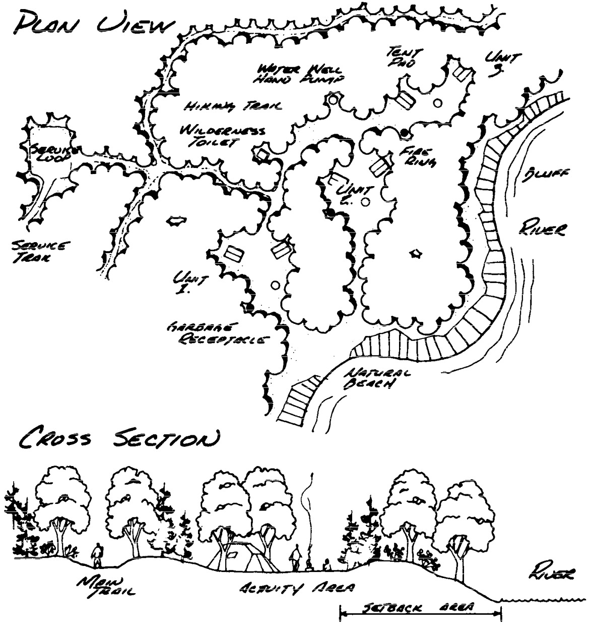
Statutory Authority:
MS s 104.35
Published Electronically:
June 11, 2008
6105.1330 REST AREA.
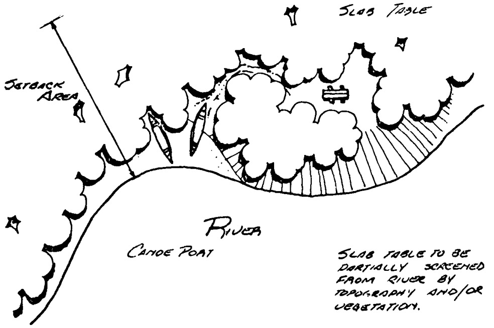
Statutory Authority:
MS s 104.35
Published Electronically:
June 11, 2008
6105.1340 BOAT ACCESS.
Statutory Authority:
MS s 104.35
Published Electronically:
June 11, 2008
6105.1350 CANOE ACCESS.

Statutory Authority:
MS s 104.35
Published Electronically:
June 11, 2008
6105.1360 CAMPGROUND.
Statutory Authority:
MS s 104.35
Published Electronically:
June 11, 2008
6105.1370 TRAIL DESIGN.
Statutory Authority:
MS s 104.35
Published Electronically:
June 11, 2008
RUM RIVER MANAGEMENT PLAN
6105.1400 DESIGNATION OF RIVER.
That portion of the Rum River from the Ogechie Lake spillway to a line crossing the river between the center lines of Rice Street and Madison Street in the city of Anoka is hereby designated a component of the Minnesota wild, scenic, and recreational rivers system.
Statutory Authority:
MS s 104.35
Published Electronically:
June 11, 2008
6105.1410 STATUTORY AUTHORITY.
This designation is made by the commissioner of the Department of Natural Resources pursuant to the authority of the Minnesota Wild and Scenic Rivers Act, Minnesota Statutes, sections 103F.301 to 103F.345.
Published Electronically:
June 11, 2008
6105.1420 SCOPE.
The designation and parts 6105.1400 to 6105.1500 apply to the river and the adjacent lands as provided for in the land use district descriptions, in part 6105.1480.
Statutory Authority:
MS s 104.35
Published Electronically:
June 11, 2008
6105.1430 CLASSIFICATION OF RIVER.
Classification:
A.
That portion of the Rum River and adjacent lands (excluding the shoreland of Shakopee Lake), from the Ogechie Lake spillway to the river's northernmost confluence with Lake Onamia is classified wild.
B.
Those portions of the Rum River and adjacent lands from the Mille Lacs CSAH 20 bridge to the Mille Lacs CSAH 9 bridge, and from the Mille Lacs CSAH 13 bridge to the T 31 N -- T 32 N line on the southern border of the Anoka County Fairgrounds in the city of Anoka, are classified scenic.
C.
Those portions of the Rum River and adjacent lands from the State Highway 27 bridge in Onamia to the Mille Lacs CSAH 20 bridge, from the Mille Lacs CSAH 9 bridge to the Mille Lacs CSAH 13 bridge, and from the T 31 N -- T 32 N line on the southern border of the Anoka County Fairgrounds in the city of Anoka to a line crossing the river between the center lines of Madison Street and Rice Street are classified recreational, in accordance with the provisions of Minnesota Statutes, sections 103F.311, subdivision 4, and 103F.315, subdivision 2, and part 6105.0060.
Published Electronically:
June 11, 2008
6105.1440 LAND USE MANAGEMENT.
Subpart 1.
Adoption of land use districts.
The commissioner of the Department of Natural Resources hereby adopts the wild, scenic, and recreational land use districts as identified in the land use district descriptions in part 6105.1480. The land use districts were derived in accordance with part 6105.0070, subpart 2, item B.
A.
Parts 6105.0010 to 6105.0250 shall apply to all lands in the wild, scenic, and recreational land use districts, except as specified in subpart 4, item G.
B.
If land is annexed, incorporated, or in any other way transferred to another jurisdiction, a moratorium shall exist on all construction, grading and filling, and vegetative cutting until the newly responsible unit of government adopts zoning for that land. The zoning shall meet the provisions of this management plan which applied to the land before the transfer. This provision does not apply to work for which lawful permits were previously issued.
Subp. 2.
Tributaries.
Parts 6105.0110, subpart 3, item B, subitem (3); 6105.0120; and 6105.0150, subpart 1 specify regulations concerning designated tributaries. Designated tributaries along the Rum River shall be:
Subp. 3.
Grading and filling.
The grading and filling provision, part 6105.0160, shall be enforced by local ordinance which shall require a grading and filling permit.
Subp. 4.
Modifications of other rules.
Certain provisions of parts 6105.0010 to 6105.0250 are modified for purposes of the management plan, as follows:
A.
Because of the erosive nature of soils along much of the Rum River, part 6105.0110, subpart 3, item C is modified to read: Structures shall not be located on slopes greater than 12 percent, unless such structures are screened from the river view with natural vegetation where practicable, the sanitary provisions of this plan are complied with, and the building permit applicant can prove to the local zoning authority that any potential erosion or sedimentation problems related to locating a structure either do not exist or that adequate measures will be taken to prevent any of these problems through special construction methods.
B.
Because of land forms and high groundwater levels encountered on lands adjacent to much of the Rum River and to help further the enforcement of Minnesota Department of Health and Minnesota Pollution Control Agency (PCA) standards relating to on-site sewage disposal systems, parts 6105.0120 and 6120.3400 are modified by adding a new subdivision reading: Local units of government shall require that both percolation-rate tests and soils boring tests be done on any proposed sites prior to approval of an on-site sewage disposal system installation permit. When new on-site sewage disposal system standards are officially adopted by the PCA, those standards shall take precedence over those of this program.
C.
Because of land forms and high groundwater levels found along the Rum River and to further the enforcement of the sanitary provisions and the subdivision regulations, parts 6105.0140 and 6120.3500 to 6120.3800 are modified by adding the following sentence to these regulations: No plat or subdivision within the land use district shall be approved by a local unit of government until the applicant for the plat or subdivision has proven to the local zoning authority, through the methods described in item B as modified in this plan that every newly platted lot found within the land use district has adequate area and a suitable location for the installation of a conforming septic tank and soil absorption system.
D.
Because of the large number of existing plats along some sections of the Rum River, part 6105.0110, subpart 1, is clarified by replacing the final phrase, "or to the greatest extent practicable," with this clause: "except that such lots which meet or exceed 60 percent or more of the lot width standards of these regulations may be considered as a separate parcel of land for the purpose of sale or development, if on-site sewage disposal systems can be installed so as to comply with these regulations." This provision shall also apply in urban areas.
E.
Because parts 6105.0080 to 6105.0200 provides neither the necessary flexibility nor the control over the great recreational development potential of the Rum River, the table of land use district uses in part 6105.0100, subpart 3 is modified so that the uses specified in part 6105.0100, subpart 3, items A, B, C, D, F, and G are amended by adding to their descriptions the following phrase: "and approval by the commissioner of natural resources." This provision shall also apply in urban areas but shall not apply to the areas and facilities noted in part 6105.1460, subpart 4.
F.
Because agricultural uses are permitted in the land use district area and because of the preexistence of agricultural buildings along most of the Rum River's adjacent lands, the maximum building height restriction contained in part 6105.0110, subpart 3, item D shall not apply to buildings used primarily for agriculture purposes.
G.
Because some areas along the Rum River have been considerably developed, have or soon will have public sewer and water available, and because the Wild and Scenic Rivers Act states that management plans shall be prepared "with no unreasonable restrictions upon compatible, preexisting, economic uses of particular tracts of land ...", the following areas are exempted from the provisions of part 6105.1440, subpart 1, item A. Within the boundaries of the municipalities, at the time of designation, of Onamia, Milaca, Princeton, Cambridge, Isanti, Anoka, Saint Francis (that portion located in the S 1/2 of Section 29, T34N-R24W, west of river only; Section 32, T34N-R24W; and the N 1/2 of Section 5, T33N-R24W) and Ramsey (that portion located in the S 1/2 Section 19, T32N-R24W; and Sections 25, 36, plus the S 1/2 of Section 24, T32N-R23W). These areas shall be considered urban areas and the following regulations shall apply within the wild, scenic, or recreational land use districts of these areas, regardless of the classification of the river, as follows: parts 6105.0010 to 6105.0070; 6105.0100, subpart 3, items A, B, C, D, F, and G; and 6105.0150 (within the building setback areas required in urban areas); parts 6105.0160, subparts 1, 2, and 4; 6105.0190; 6105.0200; part 6105.0210; parts 6105.0220 to 6105.0250; part 6120.2500 (where certain terms are not defined in parts 6105.0010 to 6105.0070); parts 6120.3100 and 6120.3200; part 6120.3300, subparts 2 and 3 (For recreational development waters); part 6120.3300, subpart 4, item C; part 6120.3300, subpart 5; part 6120.3400 (For recreational development waters); parts 6120.3500 and 6120.3800; and 6120.3900, subparts 2 and 4.
Subp. 5.
Bridges.
The proposed bridges across the Rum River located at about Section 25, T 32 N-R 25 W and at about Sections 13 and 24, T 32 N-R 25 W (also referred to as the Anoka County Road No. 20 and No. 57 bridge proposals) and the three proposed bridge crossings for U.S. Highway No. 169 in Mille Lacs County shall be considered preexisting uses of riverside lands, because they have been included in existing long-range thoroughfare plans for the area or environmental impact statements have been finalized. However, any development of these bridges shall comply with the construction and permit requirements of parts 6105.0190 and 6105.0200. In addition, reconstruction, replacement, or upgrading of existing bridge crossings shall be considered in compliance with the policy of the management plan when the procedures of parts 6105.0190 to 6105.0200 are followed.
Subp. 6.
Substandard structures.
Replacement of substandard structures may be allowed, limited, or prohibited by the local ordinance.
Statutory Authority:
MS s 104.35
Published Electronically:
June 11, 2008
6105.1450 LAND ACQUISITION.
Subpart 1.
Priority areas.
The commissioner of the Department of Natural Resources hereby adopts the fee title and scenic easement lands, as identified in the fee title descriptions and scenic easement descriptions in parts 6105.1490 and 6105.1500, as priority areas for these types of acquisition:
A.
Fee title acquisition is recommended in those areas where recreational sites are needed, and to consolidate existing blocks of public ownership, as identified in the fee title descriptions in part 6105.1500.
B.
Scenic easement acquisition is recommended in those areas having outstanding scenic, natural, or similar values as identified in the scenic easement descriptions in part 6105.1490.
C.
Because acquisition of lands or interests in land is from willing sellers at market value, some lands recommended for scenic easement acquisition may be purchased in fee title and some lands recommended for fee title acquisition may be purchased as scenic easements. These changes from the recommended acquisition can be done only with the mutual agreement by and between the state of Minnesota and the landowner(s). Furthermore, additional land or interests in land other than those recommended may be purchased within the land use districts to further the policies established in Minnesota Statutes, section 103F.305 and the management plan.
Subp. 2.
Funds for acquisition.
Land or interests in land recommended to be acquired in the plan will be acquired from willing sellers when funds are available for such purposes as provided for in Minnesota Statutes, section 103F.331.
Subp. 3.
Land exchange.
Whenever feasible, land will be exchanged in a manner prescribed by state law to acquire land in the land use districts. Land will not be exchanged, however, if such exchanges would adversely affect this or other Department of Natural Resources (DNR) management programs.
Subp. 4.
Islands.
All islands acquired by or transferred to the DNR shall be managed in a manner consistent with policy established in the Minnesota Wild and Scenic Rivers Act and this management plan.
Published Electronically:
June 11, 2008
6105.1460 RECREATION MANAGEMENT.
Subpart 1.
Policy.
As provided for in this management plan, the recreation management policy is to provide for the orderly use of public lands and waters within the wild, scenic, and recreational river land use districts. The development of selected land- and river-oriented recreational facilities and the maintenance of these will help protect the rights of private landowners, ensure quietude, prohibit trespassing, and maintain the essential quality of wild and scenic river land use districts, as provided for in part 6105.0210, subpart 1. A specific recreation management policy shall be the enforcement of the statutes and regulations pertaining to littering (Minnesota Statutes, section 609.68 and part 6105.0210, subpart 2) and the promotion and advertising of a carry-in, carry-out philosophy, that is, for river users to take their trash home with them.
Subp. 2.
Regulated use.
The recreational use of the Rum Wild, Scenic, and Recreational River and adjacent state lands will be regulated when and where considered necessary by the commissioner to ensure that the use does not adversely affect the values which qualified the river for designation.
Subp. 3.
Design specifications.
As provided for in part 6105.0100, subpart 3 and the management plan, the development of public or private recreational facilities within the wild, scenic, and recreational river land use districts shall conform to the design specification guidelines shown in part 6105.0940 and the management plan.
Subp. 4.
Priority areas.
Priority areas for recreational development include:
A.
Certain privately owned lands, which may be acquired by the DNR from willing sellers. The proposed lands and proposed uses of these lands are shown in the fee title descriptions in part 6105.1500. The exact locations of these sites may vary, depending on the availability of willing sellers, however, the total numbers of priority sites shall remain constant.
B.
Certain publicly owned lands should be developed for certain recreational uses as follows:
| Location of Site | Recommended Facilities | Governmental Unit Involved |
| T 41 N-R 26 W, Sec. 6 | Portage, access, rest area | Department of Transportation |
| T 40 N-R 27 W, Sec. 26 | Rest areas, access, campsite, other open space recreational uses | DNR, DOT or Mille Lacs County |
| T 38 N-R 27 W, Sec. 26 | Access, portage, other open space recreational uses | City of Milaca |
| T 36 N-R 23 W, Sec. 32 | Campsite, other open space recreational uses | City of Cambridge |
| T 34 N-R 24 W, Sec. 32 | Access, campground, campsite, portage, rest area and other open space recreational uses | Anoka County |
| T 33 N-R 24 W, Sec. 19 | Rest area, access | Anoka County |
| T 33 N-R 24 W, Sec. 31 & T 32 N-R 24 W, Sec. 6 | Campground, campsite, access, rest area and other open space recreational uses | Anoka County |
Subp. 5.
Maintenance funds.
The Division of Parks and Recreation shall allocate funds for maintenance of DNR recreational facilities within the Rum River land use districts from the department's river development and maintenance account.
Subp. 6.
Distribution of responsibilities.
The DNR's Enforcement Division shall discuss with the local units of government the delineation of responsibilities for the enforcement of wild, scenic, and recreational river user regulations in part 6105.0210. The Division of Enforcement shall also take appropriate action, within the limits of available funding and personnel, to insure expeditious enforcement of wild, scenic, and recreational river user regulations.
Subp. 7.
Snowmobiles.
Snowmobile use on lands in the wild, scenic, and recreational land use district shall be allowed:
Subp. 8.
Use study.
The Division of Parks and Recreation of the DNR shall arrange for a recreational use study of the Rum River, when funds are appropriated for such a purpose.
Subp. 9.
Recreational development.
Any recreational development proposed in Mille Lacs Kathio State Park shall not be subject to the provisions of part 6105.1440, subpart 4, item E, or 6105.1460, subpart 4, but shall comply with the terms of any plan approved in accordance with the Outdoor Recreation Act.
Statutory Authority:
MS s 104.35
Published Electronically:
October 8, 2013
6105.1470 ADMINISTRATION OF MANAGEMENT PLAN.
Subpart 1.
Mille Lacs County.
Mille Lacs County shall enact or amend such ordinances and maps as necessary to:
Subp. 2.
Sherburne and Isanti Counties.
Sherburne and Isanti Counties shall enact or amend such ordinances and maps as necessary to:
Subp. 3.
Anoka County.
Anoka County shall enact or amend such ordinances and maps as necessary to:
Subp. 4.
Certain municipalities.
The municipalities which are listed in part 6105.1440, subpart 4, item G as urban areas shall enact or amend such ordinances and maps as necessary to establish the land use district as identified in the land use district descriptions in part 6105.1480 and conform to the provisions required in part 6105.1440, subpart 4, item G.
Subp. 5.
Saint Francis, Ramsey, and Andover.
The municipalities of Saint Francis (all, except the S 1/2 of Section 29, T 34 N-R 24 W, west of river only; Section 32, T 34 N-R 24 W; and the N 1/2 of Section 5, T 33 N-R 24 W), Ramsey (all, except the S 1/2 of Section 19, T 32 N-R 24 W; and Sections 25, 36 and the S 1/2 of Section 24, T 32 N-R 23 W) and Andover shall enact or amend such ordinances and maps as necessary to:
Subp. 6.
More restrictive rules.
Any of the involved counties or cities may retain or adopt regulations which are more restrictive than those required by this plan.
Subp. 7.
Departmental assistance.
The DNR shall assist local units of government in implementing parts 6105.0010 to 6105.0250 and this management plan, in accordance with the provisions of Minnesota Statutes, section 103F.335, subdivision 1.
Subp. 8.
District boundaries.
The DNR shall delineate the land use district boundaries on the appropriate zoning maps for the affected local units of government.
Published Electronically:
June 11, 2008
6105.1480 LAND USE DISTRICT DESCRIPTIONS STARTING FROM MILE 145.7 AT OGECHIE LAKE SPILLWAY.
Subpart 1.
T 42 N - R 27 W.
The land use district descriptions and acreages for T 42 N - R 27 W in Mille Lacs County are as follows:
| A. | Section 8 | ||
| Government Lot 4 | Within 300 feet of the normal high-water mark only | 16.52 | |
| SW 1/4 of SE 1/4 | SW of road only | 16.00 | |
| B. | Section 15 | ||
| W 1/2 of SW 1/4 | 80.00 | ||
| Government Lot 3 | Within 300 feet of river only on S side of river | 24.60 | |
| Government Lot 2 | Within 300 feet of normal high-water mark only | 26.24 | |
| C. | Section 16 | ||
| S 1/2 of N 1/2 of NW 1/4 | 40.00 | ||
| S 1/2 of NW 1/4 | 80.00 | ||
| N 1/2 of N 1/2 of SW 1/4 | 40.00 | ||
| SW 1/4 of NE 1/4 | 40.00 | ||
| S 1/2 of SE 1/4 of NE 1/4 | 20.00 | ||
| N 1/2 of SE 1/4 | 80.00 | ||
| N 1/2 of SW 1/4 of SE 1/4 | 20.00 | ||
| SE 1/4 of SE 1/4 | 40.00 | ||
| D. | Section 17 | ||
| NE 1/4 | 160.00 | ||
| E. | Section 22 | ||
| NW 1/4 of NW 1/4 | 40.00 | ||
| Government Lot 4 | Within 300 feet of normal high-water mark | 12.00 | |
| F. | Section 23 | ||
| Government Lot 1 | Within 300 feet of normal high-water mark only | 6.90 | |
| G. | Section 24 | ||
| Government Lot 2 | Within 300 feet of normal high-water mark only | 14.00 | |
| Government Lot 3 | Within 300 feet of normal high-water mark only | 8.00 | |
| Government Lot 1 | 22.40 | ||
| Government Lot 4 | 41.60 | ||
| S 1/2 of NE 1/4 | 80.00 | ||
| SE 1/4 | 160.00 |
Subp. 2.
T 42 N - R 26 W.
The land use district descriptions and acreages for T 42 N - R 26 W in Mille Lacs County are as follows:
| A. | Section 19 | ||
| Government Lot 3 | 60.66 | ||
| Government Lot 4 | 59.90 | ||
| B. | Section 30 | ||
| Government Lot 1 | 51.10 | ||
| Government Lot 2 | Within 300 feet of normal high-water mark only | 5.00 |
Subp. 3.
T 41 N - R 26 W.
The land use district descriptions and acreages for T 41 N - R 26 W in Mille Lacs County are as follows:
| A. | Section 5 | ||
| W 1/2 of SW 1/4 | 80.00 | ||
| B. | Section 6 | ||
| NW 1/4 | Within 300 feet of normal high-water mark only | 36.36 | |
| N 1/2 of NE 1/4 | Within 300 feet of normal high-water mark only | 7.00 | |
| S 1/2 of NE 1/4 | W of U.S. highway 169 only | 76.00 | |
| NE 1/4 of SE 1/4 | 40.00 | ||
| C. | Section 7 | ||
| E 1/2 of SE 1/4 of NE 1/4 | 20.00 | ||
| NE 1/4 of SE 1/4 | 40.00 | ||
| S 1/2 of SE 1/4 | 80.00 | ||
| D. | Section 8 | ||
| W 1/2 of NW 1/4 | 80.00 | ||
| W 1/2 of E 1/2 of SW 1/4 | 40.00 | ||
| W 1/2 of SW 1/4 | 80.00 | ||
| E. | Section 18 | ||
| NE 1/4 | 160.00 | ||
| SE 1/4 | 160.00 | ||
| F. | Section 19 | ||
| NE 1/4 | 160.00 | ||
| E 1/2 of SE 1/4 | 80.00 | ||
| G. | Section 20 | ||
| W 1/2 of SW 1/4 | 80.00 | ||
| H. | Section 29 | ||
| NW 1/4 of NW 1/4 | 40.00 | ||
| S 1/2 of NW 1/4 | 80.00 | ||
| SW 1/4 | 160.00 | ||
| I. | Section 30 | ||
| NE 1/4 of NE 1/4 | 40.00 | ||
| J. | Section 32 | ||
| N 1/2 of NW 1/4 | 80.00 | ||
| E 1/2 of SW 1/4 of NW 1/4 | 20.00 | ||
| SE 1/4 of NW 1/4 | 40.00 | ||
| NE 1/4 | 160.00 | ||
| K. | Section 33 | ||
| SW 1/4 of NW 1/4 | 40.00 | ||
| NW 1/4 of SW 1/4 | 40.00 | ||
| W 1/2 of NE 1/4 of SW 1/4 | 20.00 | ||
| S 1/2 of SW 1/4 | 80.00 |
Subp. 4.
T 40 N - R 27 W.
The land use district descriptions and acreages for T 40 N - R 27 W in Mille Lacs County are as follows:
| A. | Section 12 | ||
| S 1/2 of NE 1/4 of NE 1/4 | 20.00 | ||
| S 1/2 of NE 1/4 | 80.00 | ||
| N 1/2 of NE 1/4 of SE 1/4 | 20.00 | ||
| NW 1/4 of SE 1/4 | 40.00 | ||
| SE 1/4 of NW 1/4 | 40.00 | ||
| S 1/2 of SW 1/4 of NW 1/4 | 20.00 | ||
| SW 1/4 | 160.00 | ||
| B. | Section 13 | ||
| NW 1/4 | 160.00 | ||
| SW 1/4 | 160.00 | ||
| C. | Section 24 | ||
| NW 1/4 | 160.00 | ||
| SW 1/4 | 160.00 | ||
| D. | Section 25 | ||
| NW 1/4 | 160.00 | ||
| N 1/2 of SW 1/4 | 80.00 | ||
| N 1/2 of SW 1/4 of SW 1/4 | 20.00 | ||
| E. | Section 26 | ||
| SE 1/4 | 160.00 | ||
| SE 1/4 of SW 1/4 | 40.00 | ||
| F. | Section 35 | ||
| W 1/2 of SE 1/4 | 80.00 | ||
| E 1/2 of SW 1/4 | 80.00 | ||
| W 1/2 of NE 1/4 | 80.00 | ||
| E 1/2 of NW 1/4 | 80.00 |
Subp. 5.
T 40 N - R 26 W.
The land use district descriptions and acreages for T 40 N - R 26 W in Mille Lacs County are as follows:
| A. | Section 6 | ||
| Government Lot 2 (W 1/2) | 24.90 | ||
| B. | Section 7 | ||
| NE 1/4 of NW 1/4 | 40.00 | ||
| W 1/2 of NW 1/4 | 39.00 | ||
| W 1/2 of SE 1/4 of NW 1/4 | 20.00 |
Subp. 6.
T 39 N - R 27 W.
The land use district descriptions and acreages for T 39 N - R 27 W in Mille Lacs County are as follows:
| A. | Section 2 | ||
| NW 1/4 of SW 1/4 | 40.00 | ||
| S 1/2 of NW 1/4 | 80.00 | ||
| N 1/2 of NW 1/4 | 57.39 | ||
| SW 1/4 of NE 1/4 | 40.00 | ||
| NW 1/4 of NE 1/4 | 27.85 | ||
| B. | Section 3 | ||
| SE 1/4 | 160.00 | ||
| S 1/2 of NE 1/4 | 80.00 | ||
| NE 1/4 of NE 1/4 | 29.10 | ||
| C. | Section 10 | ||
| E 1/2 | 320.00 | ||
| D. | Section 11 | ||
| W 1/2 of SW 1/4 of SW 1/4 | 20.00 | ||
| E. | Section 14 | ||
| W 1/2 of NW 1/4 of NW 1/4 | 20.00 | ||
| W 1/2 of SW 1/4 of NW 1/4 | 20.00 | ||
| F. | Section 15 | ||
| E 1/2 | 320.00 | ||
| G. | Section 22 | ||
| E 1/2 | 320.00 | ||
| H. | Section 26 | ||
| SW 1/4 | 160.00 | ||
| SW 1/4 of SE 1/4 | 40.00 | ||
| SE 1/4 of NW 1/4 | 40.00 | ||
| W 1/2 of NW 1/4 | 80.00 | ||
| I. | Section 27 | ||
| E 1/2 of NE 1/4 | 80.00 | ||
| J. | Section 35 | ||
| NE 1/4 | 160.00 | ||
| NE 1/4 of NW 1/4 | 40.00 | ||
| E 1/2 of SE 1/4 of NW 1/4 | 20.00 | ||
| SE 1/4 | 160.00 | ||
| NE 1/4 of NE 1/4 of SW 1/4 | 10.00 | ||
| S 1/2 of NE 1/4 of SW 1/4 | 20.00 | ||
| SE 1/4 of SW 1/4 | 40.00 |
Subp. 7.
T 38 N - R 27 W.
The land use district descriptions and acreages for T 38 N - R 27 W in Mille Lacs County are as follows:
| A. | Section 1 | ||
| SW 1/4 of NW 1/4 | 40.00 | ||
| W 1/2 of SW 1/4 | 80.00 | ||
| B. | Section 2 | ||
| E 1/2 of SE 1/4 | 80.00 | ||
| SE 1/4 of NW 1/4 | 40.00 | ||
| S 1/2 of NE 1/4 | 80.00 | ||
| NE 1/4 of NW 1/4 | 41.98 | ||
| NW 1/4 of NE 1/4 | 41.68 | ||
| NE 1/4 of NE 1/4 | 41.37 | ||
| C. | Section 11 | ||
| SE 1/4 | 160.00 | ||
| S 1/2 of NE 1/4 | 80.00 | ||
| NE 1/4 of NE 1/4 | 40.00 | ||
| D. | Section 12 | ||
| W 1/2 of NW 1/4 | 80.00 | ||
| NW 1/4 of NW 1/4 of SW 1/4 | 10.00 | ||
| E. | Section 13 | ||
| SW 1/4 of SW 1/4 | 40.00 | ||
| F. | Section 14 | ||
| NW 1/4 of NE 1/4 | 40.00 | ||
| W 1/2 of NE 1/4 of NE 1/4 | 20.00 | ||
| SW 1/4 of NE 1/4 | 40.00 | ||
| NW 1/4 of SE 1/4 | 40.00 | ||
| SW 1/4 of SE 1/4 | 40.00 | ||
| SE 1/4 of SE 1/4 | 40.00 | ||
| NE 1/4 of SW 1/4 | 40.00 | ||
| E 1/2 of NW 1/4 | 80.00 | ||
| G. | Section 23 | ||
| E 1/2 of NE 1/4 | 80.00 | ||
| E 1/2 of SW 1/4 of NE 1/4 | 20.00 | ||
| E 1/2 of SE 1/4 | 80.00 | ||
| E 1/2 of W 1/2 of SE 1/4 | 40.00 | ||
| H. | Section 24 | ||
| W 1/2 of NW 1/4 | 80.00 | ||
| NW 1/4 of SW 1/4 | 40.00 | ||
| I. | Section 25 | ||
| W 1/2 | Within 300 feet of Rum River only | 8.00 | |
| J. | Section 26 | ||
| E 1/2 | Within 300 feet of Rum River only | 84.85 | |
| K. | Section 35 | ||
| NE 1/4 of NE 1/4 | Within 300 feet of Rum River only | 20.00 | |
| L. | Section 36 | ||
| N 1/2 | Within 300 feet of Rum River only | 57.17 | |
| E 1/2 of NE 1/4 of SW 1/4 | 20.00 | ||
| N 1/2 of SE 1/4 | 80.00 | ||
| SE 1/4 of SE 1/4 | 40.00 | ||
| SW 1/4 of SE 1/4 | E of U.S. Hwy 169 only | 32.00 | |
Subp. 8.
T 37 N - R 27 W.
The land use district description and acreages for T 37 N - R 27 W in Mille Lacs County are as follows:
| Section 1 | |||
| NE 1/4 of NE 1/4 | 35.53 | ||
| SE 1/4 of NE 1/4 | 40.00 | ||
| NW 1/4 of NE 1/4 | E of U.S. Hwy 169 only | 12.00 |
Subp. 9.
T 37 N - R 26 W.
The land use district descriptions and acreages for T 37 N - R 26 W in Mille Lacs County are as follows:
| A. | Section 5 | ||
| W 1/2 of NE 1/4 of SW 1/4 | 20.00 | ||
| SE 1/4 of SW 1/4 | 40.00 | ||
| NW 1/4 of SW 1/4 | 40.00 | ||
| SW 1/4 of SW 1/4 | 40.00 | ||
| SW 1/4 of NW 1/4 | 40.00 | ||
| B. | Section 6 | ||
| NE 1/4 of NE 1/4 | 37.96 | ||
| NW 1/4 of NE 1/4 | 37.36 | ||
| S 1/2 of NE 1/4 | 80.00 | ||
| E 1/2 of SE 1/4 | 80.00 | ||
| W 1/2 of NW 1/4 | 54.48 | ||
| NE 1/4 of NW 1/4 | 36.76 | ||
| SE 1/4 of NW 1/4 | 40.00 | ||
| N 1/2 of NW 1/4 of SW 1/4 | 15.92 | ||
| N 1/2 of NE 1/4 of SW 1/4 | 20.00 | ||
| N 1/2 of NW 1/4 of SE 1/4 | 20.00 | ||
| C. | Section 7 | ||
| E 1/2 of NE 1/4 | 80.00 | ||
| E 1/2 of SE 1/4 | 80.00 | ||
| D. | Section 8 | ||
| W 1/2 of NW 1/4 | 80.00 | ||
| S 1/2 of SE 1/4 of NW 1/4 | 20.00 | ||
| SW 1/4 | 160.00 | ||
| S 1/2 of S 1/2 of NE 1/4 | 40.00 | ||
| SE 1/4 | 160.00 | ||
| E. | Section 9 | ||
| S 1/2 of SW 1/4 of NW 1/4 | 20.00 | ||
| W 1/2 of SW 1/4 | 80.00 | ||
| SE 1/4 of SW 1/4 | 40.00 | ||
| F. | Section 15 | ||
| S 1/2 of NW 1/4 of SW 1/4 | 20.00 | ||
| SW 1/4 of SW 1/4 | 40.00 | ||
| G. | Section 16 | ||
| NW 1/4 of NE 1/4 | 40.00 | ||
| NW 1/4 of SE 1/4 of NE 1/4 | 10.00 | ||
| S 1/2 of SE 1/4 of NE 1/4 | 20.00 | ||
| SW 1/4 of NE 1/4 | 40.00 | ||
| SE 1/4 | 160.00 | ||
| NE 1/4 of NW 1/4 of NW 1/4 | 10.00 | ||
| E 1/2 of NW 1/4 | 80.00 | ||
| H. | Section 21 | ||
| N 1/2 of NE 1/4 | 80.00 | ||
| SE 1/4 of NE 1/4 | 40.00 | ||
| NE 1/4 of SE 1/4 | 40.00 | ||
| I. | Section 22 | ||
| S 1/2 of SW 1/4 of NE 1/4 | 20.00 | ||
| W 1/2 of SE 1/4 | 80.00 | ||
| SW 1/4 of NE 1/4 of SE 1/4 | 10.00 | ||
| W 1/2 of SE 1/4 of SE 1/4 | 20.00 | ||
| SW 1/4 | 160.00 | ||
| W 1/2 of NW 1/4 | 80.00 | ||
| SE 1/4 of NW 1/4 | 40.00 | ||
| J. | Section 26 | ||
| NW 1/4 of NW 1/4 | 40.00 | ||
| NW 1/4 of SW 1/4 | NW of road | 20.00 | |
| SW 1/4 of NW 1/4 | NW of road | 34.00 | |
| K. | Section 27 | ||
| NE 1/4 | 160.00 | ||
| SE 1/4 | 160.00 | ||
| L. | Section 34 | ||
| NE 1/4 | 160.00 | ||
| SE 1/4 | 160.00 | ||
| E 1/2 of NW 1/4 | 80.00 |
Subp. 10.
T 36 N - R 26 W.
The land use district descriptions and acreages for T 36 N - R 26 W in Mille Lacs County are as follows:
| A. | Section 3 | ||
| NE 1/4 of NE 1/4 | 45.93 | ||
| NW 1/4 of NE 1/4 | 45.68 | ||
| SW 1/4 of NE 1/4 | 40.00 | ||
| NE 1/4 of NW 1/4 | 45.43 | ||
| SE 1/4 of NW 1/4 | 40.00 | ||
| SW 1/4 of NW 1/4 | 40.00 | ||
| SW 1/4 | 160.00 | ||
| B. | Section 4 | ||
| SE 1/4 of SE 1/4 | SE of road | 3.00 | |
| C. | Section 9 | ||
| E 1/2 of NE 1/4 | 80.00 | ||
| E 1/2 of SE 1/4 | 80.00 | ||
| D. | Section 10 | ||
| W 1/2 of NW 1/4 | 80.00 | ||
| W 1/2 of SW 1/4 | 80.00 | ||
| E. | Section 15 | ||
| W 1/2 of NW 1/4 | 80.00 | ||
| W 1/2 of SW 1/4 | 80.00 | ||
| F. | Section 16 | ||
| S 1/2 of NE 1/4 | 80.00 | ||
| NE 1/4 of NE 1/4 | 40.00 | ||
| E 1/2 of NW 1/4 of NE 1/4 | 20.00 | ||
| N 1/2 of SE 1/4 | 80.00 | ||
| SE 1/4 of SE 1/4 | 40.00 | ||
| E 1/2 of SW 1/4 of SE 1/4 | 20.00 | ||
| G. | Section 21 | ||
| E 1/2 of NE 1/4 | 80.00 | ||
| H. | Section 22 | ||
| S 1/2 of NW 1/4 | 80.00 | ||
| NW 1/4 of NW 1/4 | 40.00 | ||
| SW 1/4 | 160.00 | ||
| I. | Section 27 | ||
| W 1/2 of NW 1/4 | 80.00 | ||
| W 1/2 of NE 1/4 of NW 1/4 | 20.00 | ||
| W 1/2 of SE 1/4 of NW 1/4 | W of road | 19.00 | |
| NE 1/4 of SW 1/4 | W of road | 6.00 | |
| W 1/2 of SW 1/4 | NW of road | 40.00 | |
| J. | Section 28 | ||
| SE 1/4 of NE 1/4 | 40.00 | ||
| E 1/2 of SE 1/4 | 80.00 | ||
| SW 1/4 of NE 1/4 | S and E of streets nearest river | 8.00 | |
| W 1/2 of SE 1/4 | E of 5th Avenue only | 20.00 | |
| K. | Section 33 | ||
| E 1/2 of NE 1/4 | 80.00 | ||
| NW 1/4 of NE 1/4 | E of streets nearest river | 10.00 | |
| SW 1/4 of NE 1/4 | E of 5th Avenue only | 6.00 | |
| E 1/2 of E 1/2 of SE 1/4 | 40.00 | ||
| L. | Section 34 | ||
| SW 1/4 of NW 1/4 of NW 1/4 | 10.00 | ||
| SW 1/4 of NW 1/4 | 40.00 | ||
| SW 1/4 of SE 1/4 of NW 1/4 | 10.00 | ||
| W 1/2 of NE 1/4 of SW 1/4 | 20.00 | ||
| W 1/2 of SW 1/4 | 80.00 | ||
| SE 1/4 of SW 1/4 | 40.00 | ||
| W 1/2 of SW 1/4 of SE 1/4 | 20.00 |
Subp. 11.
T 35 N - R 26 W.
The land use district descriptions and acreages for T 35 N - R 26 W in Sherburne County are as follows:
| A. | Section 1 | ||
| S 1/2 of SW 1/4 | 80.00 | ||
| S 1/2 of NW 1/4 of SW 1/4 | 20.00 | ||
| SW 1/4 of NE 1/4 of SW 1/4 | 10.00 | ||
| S 1/2 of SW 1/4 of SE 1/4 | 20.00 | ||
| SE 1/4 of SE 1/4 | 40.00 | ||
| SE 1/4 of NE 1/4 of SE 1/4 | 10.00 | ||
| B. | Section 2 | ||
| S 1/2 of SE 1/4 | 80.00 | ||
| S 1/2 of NW 1/4 of SW 1/4 | 20.00 | ||
| S 1/2 of SW 1/4 | 80.00 | ||
| C. | Section 3 | ||
| W 1/2 of NW 1/4 of NE 1/4 | 19.34 | ||
| SW 1/4 of NE 1/4 | 40.00 | ||
| S 1/2 of NW 1/4 | 80.00 | ||
| NW 1/4 of NW 1/4 | 39.67 | ||
| NE 1/4 of NW 1/4 | 39.17 | ||
| E 1/2 of SE 1/4 of SW 1/4 | 20.00 | ||
| NE 1/4 of SW 1/4 | 40.00 | ||
| SE 1/4 | 160.00 | ||
| D. | Section 4 | ||
| E 1/2 of NE 1/4 of NE 1/4 | 19.18 | ||
| E. | Section 10 | ||
| NE 1/4 of NE 1/4 | 40.00 | ||
| F. | Section 11 | ||
| NW 1/4 | 160.00 | ||
| N 1/2 of NE 1/4 | 80.00 | ||
| N 1/2 of SW 1/4 of NE 1/4 | 20.00 | ||
| G. | Section 12 | ||
| N 1/2 of NW 1/4 | 80.00 | ||
| N 1/2 of NE 1/4 | 80.00 | ||
| SE 1/4 of NE 1/4 | 40.00 | ||
| N 1/2 of SE 1/4 of NE 1/4 | 20.00 |
Subp. 12.
T 35 N - R 25 W.
The land use district descriptions and acreages for T 35 N - R 25 W in Isanti County are as follows:
| A. | Section 1 | ||
| SW 1/4 | 160.00 | ||
| W 1/2 of SW 1/4 | 80.00 | ||
| S 1/2 of NW 1/4 | 80.00 | ||
| S 1/2 of NE 1/4 | 80.00 | ||
| NW 1/4 of NW 1/4 | 43.49 | ||
| NE 1/4 of NW 1/4 | 43.46 | ||
| NW 1/4 of NE 1/4 | 43.21 | ||
| NE 1/4 of NE 1/4 | 43.11 | ||
| B. | Section 5 | ||
| NW 1/4 of SW 1/4 | 40.00 | ||
| SW 1/4 of SW 1/4 | 40.00 | ||
| SE 1/4 of SW 1/4 | 40.00 | ||
| SW 1/4 of SE 1/4 | 40.00 | ||
| C. | Section 6 | ||
| W 1/2 of SW 1/4 | 80.00 | ||
| SE 1/4 | 160.00 | ||
| E 1/2 of SW 1/4 | 80.00 | ||
| D. | Section 7 | ||
| W 1/2 of NW 1/4 | 48.04 | ||
| NE 1/4 of NW 1/4 | 40.00 | ||
| NE 1/4 of NE 1/4 | 40.00 | ||
| SE 1/4 of NE 1/4 | 40.00 | ||
| E. | Section 8 | ||
| N 1/2 | 320.00 | ||
| F. | Section 9 | ||
| NW 1/4 | S of road only | 156.00 | |
| NW 1/4 of SW 1/4 | 40.00 | ||
| E 1/2 of SW 1/4 | 80.00 | ||
| SW 1/4 of NE 1/4 | 40.00 | ||
| S 1/2 of SE 1/4 of NE 1/4 | 20.00 | ||
| SE 1/4 | 160.00 | ||
| G. | Section 10 | ||
| SW 1/4 | 160.00 | ||
| S 1/2 of SE 1/4 | 80.00 | ||
| S 1/2 of NE 1/4 of SE 1/4 | 20.00 | ||
| H. | Section 11 | ||
| NW 1/4 | 160.00 | ||
| SW 1/4 | 160.00 | ||
| NE 1/4 | 160.00 | ||
| N 1/2 of SE 1/4 | 80.00 | ||
| SW 1/4 of SE 1/4 | 40.00 | ||
| I. | Section 12 | ||
| NW 1/4 | 160.00 | ||
| N 1/2 of SW 1/4 of NE 1/4 | 20.00 | ||
| NW 1/4 of NE 1/4 | 40.00 | ||
| NW 1/4 of SW 1/4 | 40.00 | ||
| J. | Section 14 | ||
| NW 1/4 of NW 1/4 | 40.00 | ||
| K. | Section 15 | ||
| N 1/2 of NW 1/4 | N of Hwy 5 only | 70.00 | |
| NW 1/4 of NE 1/4 | 40.00 | ||
| NE 1/4 of NE 1/4 | 40.00 | ||
| L. | Section 16 | ||
| N 1/2 of NE 1/4 of NE 1/4 | N of Hwy 5 only | 10.00 |
Subp. 13.
T 36 N - R 25 W.
The land use district description and acreage for T 36 N - R 25 W in Isanti County are as follows:
| Section 36 | |||
| SE 1/4 | S of Hwy 39 and E of Hwy 47 only | 42.00 |
Subp. 14.
T 36 N - R 24 W.
The land use district descriptions and acreages for T 36 N - R 24 W in Isanti County are as follows:
| A. | Section 13 | ||
| SW 1/4 of NW 1/4 | 40.00 | ||
| Government Lot 1 | 26.64 | ||
| Government Lot 2 | 39.78 | ||
| Government Lot 3 | 31.55 | ||
| Government Lot 4 | 52.41 | ||
| B. | Section 14 | ||
| S 1/2 of NE 1/4 | 80.00 | ||
| SE 1/4 of SW 1/4 | 40.00 | ||
| Government Lot 1 | 56.17 | ||
| Government Lot 2 | 49.06 | ||
| Government Lot 3 | 44.70 | ||
| C. | Section 22 | ||
| S 1/2 of NE 1/4 | 80.00 | ||
| Government Lot 1 | 56.65 | ||
| Government Lot 2 | 45.90 | ||
| Government Lot 3 | .78 | ||
| Government Lot 4 | 47.19 | ||
| D. | Section 23 | ||
| Government Lot 1 | 23.86 | ||
| Government Lot 2 | 38.13 | ||
| Government Lot 3 | 41.47 | ||
| Government Lot 4 | 29.71 | ||
| Government Lot 5 | 39.28 | ||
| Government Lot 6 | 55.33 | ||
| Government Lot 7 | 54.49 | ||
| Government Lot 8 | 34.80 | ||
| SW 1/4 of SW 1/4 | 40.00 | ||
| NW 1/4 of NW 1/4 | 40.00 | ||
| SE 1/4 of NE 1/4 | 40.00 | ||
| E. | Section 24 | ||
| E 1/2 of NW 1/4 of NW 1/4 | 20.00 | ||
| SE 1/4 of NW 1/4 | 40.00 | ||
| Government Lot 1 | 37.36 | ||
| Government Lot 2 | 23.44 | ||
| Government Lot 3 | 51.86 | ||
| Government Lot 4 | 45.18 | ||
| Government Lot 5 | 32.53 | ||
| F. | Section 26 | ||
| NW 1/4 of NW 1/4 | 40.00 | ||
| G. | Section 27 | ||
| NE 1/4 of NW 1/4 | 40.00 | ||
| Government Lot 1 | 53.11 | ||
| Government Lot 2 | 19.06 | ||
| Government Lot 3 | 43.46 | ||
| Government Lot 4 | 24.85 | ||
| Government Lot 5 | 21.81 | ||
| Government Lot 6 | 21.52 | ||
| Government Lot 7 | 39.84 | ||
| Government Lot 8 | 36.15 | ||
| N 1/2 of NE 1/4 of SW 1/4 | 20.00 | ||
| SW 1/4 of NE 1/4 of SW 1/4 | 10.00 | ||
| N 1/2 of NW 1/4 of SE 1/4 | 20.00 | ||
| Government Lot 9 | .35 | ||
| H. | Section 28 | ||
| SE 1/4 of SE 1/4 | 40.00 | ||
| NW 1/4 of SW 1/4 | 40.00 | ||
| Government Lot 1 | 13.31 | ||
| Government Lot 2 | 50.11 | ||
| Government Lot 3 | 51.46 | ||
| Government Lot 4 | 29.77 | ||
| Government Lot 5 | 31.25 | ||
| Government Lot 6 | 25.57 | ||
| Government Lot 7 | 21.95 | ||
| SE 1/4 of NE 1/4 | 40.00 | ||
| S 1/2 of S 1/2 of NW 1/4 | 40.00 | ||
| I. | Section 29 | ||
| Government Lot 1 | 41.16 | ||
| Government Lot 2 | Except N 20 Acres | 23.66 | |
| Government Lot 6 | 40.02 | ||
| Government Lot 7 | 33.05 | ||
| Government Lot 3 | 26.31 | ||
| Government Lot 4 | 18.43 | ||
| Government Lot 5 | 18.29 | ||
| J. | Section 30 | ||
| SE 1/4 of SE 1/4 | 40.00 | ||
| K. | Section 31 | ||
| NW 1/4 of NW 1/4 | 38.20 | ||
| Government Lot 4 | 53.45 | ||
| Government Lot 2 | 25.88 | ||
| Government Lot 3 | 40.82 | ||
| Government Lot 6 | 48.21 | ||
| Government Lot 7 | 41.19 | ||
| Government Lot 8 | 34.78 | ||
| Government Lot 1 | 36.24 | ||
| Government Lot 5 | 39.06 | ||
| Government Lot 9 | 51.68 | ||
| SE 1/4 of SW 1/4 | 40.00 | ||
| NW 1/4 of SE 1/4 | NW of road only | 4.00 | |
| L. | Section 32 | ||
| NE 1/4 of NE 1/4 | 40.00 | ||
| NW 1/4 of NE 1/4 | 40.00 | ||
| Government Lot 2 | 39.42 | ||
| Government Lot 1 | 39.73 | ||
| M. | Section 33 | ||
| NW 1/4 of NW 1/4 | 40.00 |
Subp. 15.
T 36 N - R 23 W.
The land use district descriptions and acreages for T 36 N - R 23 W in Isanti County are as follows:
| A. | Section 7 | ||
| Government Lot 1 | 39.11 | ||
| Government Lot 2 | 20.26 | ||
| Government Lot 3 | 21.22 | ||
| Government Lot 4 | 37.63 | ||
| Government Lot 5 | 28.51 | ||
| B. | Section 8 | ||
| S 1/2 of SE 1/4 of NW 1/4 | 20.00 | ||
| S 1/2 of SW 1/4 of NE 1/4 | 20.00 | ||
| Government Lot 1 | 32.58 | ||
| Government Lot 2 | 53.76 | ||
| Government Lot 3 | 41.37 | ||
| Government Lot 4 | 38.85 | ||
| Government Lot 5 | 47.51 | ||
| C. | Section 17 | ||
| Government Lot 1 | 41.08 | ||
| Government Lot 2 | 36.77 | ||
| Government Lot 3 | 57.49 | ||
| Government Lot 4 | 27.04 | ||
| Government Lot 5 | 25.00 | ||
| Government Lot 6 | 6.35 | ||
| Government Lot 7 | 52.54 | ||
| Government Lot 8 | 26.73 | ||
| Government Lot 9 | 23.90 | ||
| Government Lot 10 | 9.42 | ||
| SW 1/4 of NE 1/4 | 40.00 | ||
| NW 1/4 of SE 1/4 | 40.00 | ||
| SW 1/4 of SE 1/4 | 40.00 | ||
| D. | Section 18 | ||
| Government Lot 1 | 32.85 | ||
| Government Lot 2 | 36.36 | ||
| Government Lot 3 | 37.18 | ||
| Government Lot 4 | .42 | ||
| Government Lot 5 | 38.20 | ||
| Government Lot 6 | 39.83 | ||
| Government Lot 7 | 40.56 | ||
| Government Lot 8 | 36.66 | ||
| Government Lot 9 | 32.67 | ||
| Government Lot 10 | 29.68 | ||
| Government Lot 11 | 32.52 | ||
| SW 1/4 of SE 1/4 | 40.00 | ||
| SW 1/4 of NE 1/4 | 40.00 | ||
| NW 1/4 of NE 1/4 | 40.00 | ||
| SE 1/4 of NE 1/4 | 40.00 | ||
| NW 1/4 of SW 1/4 | 40.30 | ||
| SW 1/4 of NW 1/4 | 40.50 | ||
| Government Lot 12 | 3.82 | ||
| E. | Section 19 | ||
| Government Lot 1 | 10.63 | ||
| Government Lot 2 | 22.64 | ||
| NE 1/4 of NW 1/4 | 40.00 | ||
| F. | Section 20 | ||
| Government Lot 1 | 2.83 | ||
| Government Lot 2 | 30.15 | ||
| Government Lot 3 | 38.31 | ||
| Government Lot 4 | 54.90 | ||
| Government Lot 5 | Except E 20 acres | 16.81 | |
| Government Lot 6 | 13.38 | ||
| Government Lot 7 | 37.50 | ||
| Government Lot 8 | 43.62 | ||
| Government Lot 9 | 24.45 | ||
| Government Lot 10 | 32.91 | ||
| NW 1/4 of NE 1/4 | 40.00 | ||
| SW 1/4 of NW 1/4 | 40.00 | ||
| NW 1/4 of SW 1/4 | 40.00 | ||
| SW 1/4 of SW 1/4 | 40.00 | ||
| W 1/2 of NE 1/4 of SE 1/4 | 20.00 | ||
| G. | Section 29 | ||
| NW 1/4 of NW 1/4 | 40.00 | ||
| Government Lot 1 | .69 | ||
| Government Lot 2 | Except E 40 acres | 19.54 | |
| Government Lot 3 | Excluding that part within the city of Cambridge (as of January 1977) | 35.12 | |
| Government Lot 4 | Excluding that part within the city of Cambridge (as of January 1977) | 31.08 | |
| Government Lot 5 | Excluding that part within the city of Cambridge (as of January 1977) | 20.63 | |
| Government Lot 6 | 47.09 | ||
| Government Lot 7 | 26.18 | ||
| Government Lot 8 | 50.52 | ||
| Government Lot 9 | 28.43 | ||
| W 1/2 of SW 1/4 of NE 1/4 | 20.00 | ||
| H. | Section 30 | ||
| E 1/2 | E of CSAH 14 only | 3.00 | |
| I. | Section 31 | ||
| E 1/2 of SE 1/4 of SE 1/4 | 20.00 | ||
| NE 1/4 of SE 1/4 | Within 300 feet of Rum River only | 3.00 | |
| J. | Section 32 | ||
| Government Lot 1 | Within 300 feet of the Rum River only | 8.95 | |
| Government Lot 2 | Within 300 feet of the Rum River only | 8.95 | |
| Government Lot 3 | Within 300 feet of the Rum River only | 13.40 | |
| Government Lot 4 | Within 300 feet of the Rum River only | 8.95 | |
| Government Lot 5 | Within 300 feet of the Rum River only | 29.50 | |
| Government Lot 6 | Within 300 feet of the Rum River only | 14.50 | |
| Government Lot 7 | Within 300 feet of the Rum River only | 4.50 | |
| Government Lot 8 | Within 300 feet of the Rum River only | 10.00 | |
| Government Lot 9 | Within 300 feet of the Rum River only | 9.50 |
Subp. 16.
T 35 N - R 23 W.
The land use district descriptions and acreages for T 35 N - R 23 W in Isanti County are as follows:
| A. | Section 5 | ||
| Government Lot 6 | 1.20 | ||
| Government Lot 7 | .45 | ||
| Government Lot 4 | 37.00 | ||
| Government Lot 5 | 36.75 | ||
| Government Lot 3 | 1.30 | ||
| W 1/2 of SW 1/4 | N and W of East Rum River Drive only | 11.00 | |
| B. | Section 6 | ||
| Government Lot 1 | 15.10 | ||
| Government Lot 2 | 2.35 | ||
| Government Lot 3 | 38.95 | ||
| Government Lot 4 | E of road only | 30.40 | |
| Government Lot 5 | E of road only | 30.40 | |
| Government Lot 6 | Except W 40 acres | 26.40 | |
| C. | Section 7 | ||
| Government Lot 1 | Except E 40 acres | 18.00 | |
| Government Lot 2 | Except E 20 acres | 20.54 | |
| Government Lot 3 | W of Rum River Drive only | 13.00 | |
| Government Lot 4 | W of Rum River Drive only | 11.00 | |
| Government Lot 5 | Except W 40 acres | 19.60 | |
| Government Lot 6 | Except W 20 acres | 24.73 | |
| Government Lot 7 | 33.83 | ||
| Government Lot 8 | Except W 40 acres | 16.90 | |
| D. | Section 18 | ||
| Government Lot 1 | 33.50 | ||
| Government Lot 2 | Except E 20 acres | 33.00 | |
| Government Lot 3 | 34.80 | ||
| Government Lot 4 | Except E 40 acres | 20.25 | |
| Government Lot 5 | 53.40 | ||
| Government Lot 6 | 38.40 | ||
| Government Lot 7 | 49.15 | ||
| Government Lot 8 | 21.70 | ||
| Government Lot 9 | 5.90 | ||
| E. | Section 19 | ||
| Government Lot 1 | .10 | ||
| Government Lot 2 | Except E 20 acres | 19.95 | |
| Government Lot 3 | 60.85 | ||
| W 1/2 of SW 1/4 | 61.65 | ||
| F. | Section 30 | ||
| Government Lot 1 | Except E 40 acres | 23.06 | |
| Government Lot 2 | Except E 40 acres | 23.12 | |
| Government Lot 3 | 1.05 | ||
| G. | Section 31 | ||
| W 1/2 of NW 1/4 of NW 1/4 | 16.26 |
Subp. 17.
T 35 N - R 24 W.
The land use district descriptions and acreages for T 35 N - R 24 W in Isanti County are as follows:
| A. | Section 13 | ||
| S 1/2 of NE 1/4 of SE 1/4 | 20.00 | ||
| Government Lot 1 | 26.43 | ||
| Government Lot 2 | 7.66 | ||
| B. | Section 24 | ||
| Government Lot 1 | 42.22 | ||
| Government Lot 2 | 27.35 | ||
| Government Lot 3 | E of River Ridge Road only | 12.79 | |
| Government Lot 4 | E of River Ridge Road only | 16.67 | |
| Government Lot 5 | 6.21 | ||
| Government Lot 6 | 54.78 | ||
| Government Lot 7 | 28.42 | ||
| C. | Section 25 | ||
| Government Lot 1 | E of River Ridge Road only | 12.61 | |
| Government Lot 2 | E of River Ridge Road only | 15.42 | |
| Government Lot 3 | 36.64 | ||
| Government Lot 4 | 21.40 | ||
| Government Lot 5 | 14.48 | ||
| Government Lot 6 | 44.01 | ||
| D. | Section 36 | ||
| Government Lot 1 | 56.05 | ||
| Government Lot 2 | 41.59 | ||
| Government Lot 3 | 46.92 | ||
| Government Lot 4 | 33.74 | ||
| Government Lot 5 | 41.56 | ||
| Government Lot 6 | 30.90 | ||
| Government Lot 7 | 31.74 | ||
| Government Lot 8 | 19.83 | ||
| NE 1/4 of SE 1/4 | 40.00 |
Subp. 18.
T 34 N - R 24 W.
The land use district descriptions and acreages for T 34 N - R 24 W in Isanti County are as follows:
| A. | Section 1 | ||
| NW 1/4 of NW 1/4 | 40.26 | ||
| NE 1/4 of NW 1/4 | 40.76 | ||
| NW 1/4 of NE 1/4 | 41.26 | ||
| S 1/2 of NW 1/4 | 80.00 | ||
| W 1/2 of SW 1/4 | 80.00 | ||
| NE 1/4 of SW 1/4 | NW of road only | 4.00 | |
| B. | Section 2 | ||
| E 1/2 of NE 1/4 of SE 1/4 | 20.00 | ||
| SE 1/4 of SE 1/4 | 40.00 | ||
| C. | Section 10 | ||
| E 1/2 of SE 1/4 of SE 1/4 | SE of road only | 5.00 | |
| D. | Section 11 | ||
| NE 1/4 | 160.00 | ||
| SE 1/4 of NW 1/4 | 40.00 | ||
| N 1/2 of NW 1/4 of SE 1/4 | 20.00 | ||
| SW 1/4 | 160.00 | ||
| E. | Section 14 | ||
| W 1/2 of NW 1/4 | 80.00 | ||
| W 1/2 of SW 1/4 | NW of road only | 25.00 | |
| F. | Section 15 | ||
| NE 1/4 of NE 1/4 | 40.00 | ||
| SE 1/4 of NE 1/4 | 40.00 | ||
| SE 1/4 | 160.00 | ||
| E 1/2 of SW 1/4 | 80.00 | ||
| SW 1/4 of SW 1/4 | 40.00 | ||
| G. | Section 20 | ||
| SE 1/4 of SE 1/4 | SE of road only | 12.00 | |
| H. | Section 21 | ||
| E 1/2 of NE 1/4 | 80.00 | ||
| NE 1/4 of SE 1/4 | 40.00 | ||
| SW 1/4 of SE 1/4 | 40.00 | ||
| NW 1/4 of SE 1/4 | S of road only | 30.00 | |
| SW 1/4 | S of road only | 74.00 | |
| I. | Section 22 | ||
| NW 1/4 of NW 1/4 | 40.00 | ||
| NE 1/4 of NW 1/4 | 40.00 | ||
| W 1/2 of SW 1/4 of NW 1/4 | 20.00 | ||
| N 1/2 of NW 1/4 of NE 1/4 | 20.00 |
Subp. 19.
T 34 N - R 24 W.
The land use district descriptions and acreages for T 34 N - R 24 W in Anoka County are as follows:
| A. | Section 28 | ||
| N 1/2 of NE 1/4 of NW 1/4 | 20.00 | ||
| NW 1/4 of NW 1/4 | 40.00 | ||
| B. | Section 29 | ||
| S 1/2 of NE 1/4 | 80.00 | ||
| NE 1/4 of NE 1/4 | 40.00 | ||
| NW 1/4 of NE 1/4 | SE of Riverbank Lane only | 17.00 | |
| SE 1/4 | 160.00 | ||
| SW 1/4 | 160.00 | ||
| S 1/2 of NW 1/4 | 80.00 | ||
| S 1/2 of N 1/2 of NW 1/4 | 40.00 | ||
| C. | Section 32 | ||
| NW 1/4 of NW 1/4 | NE of road only | 5.00 | |
| NE 1/4 of NW 1/4 | 40.00 | ||
| SE 1/4 of NW 1/4 | 40.00 | ||
| SW 1/4 of NE 1/4 | 40.00 | ||
| W 1/2 of SE 1/4 of NE 1/4 | NW of road only | 16.00 | |
| NW 1/4 of SE 1/4 | 40.00 | ||
| NE 1/4 of SE 1/4 | W of road only | 3.00 | |
| E 1/2 of NE 1/4 of SW 1/4 | 20.00 | ||
| S 1/2 of S 1/2 | within 300 feet of Rum River only | 21.21 |
Subp. 20.
T 33 N - R 24 W.
The land use district descriptions and acreages for T 33 N - R 24 W in Anoka County are as follows:
| A. | Section 5 | ||
| NE 1/4 of NW 1/4 | within 300 feet of the Rum River only | 14.00 | |
| NW 1/4 of NE 1/4 | 36.58 | ||
| NE 1/4 of NE 1/4 | W of road only | 11.00 | |
| SW 1/4 of NE 1/4 | 40.00 | ||
| SE 1/4 of NE 1/4 | W of road only | 12.00 | |
| E 1/2 of SE 1/4 of NW 1/4 | 20.00 | ||
| W 1/2 of SE 1/4 | 80.00 | ||
| E 1/2 of SW 1/4 | 80.00 | ||
| B. | Section 8 | ||
| E 1/2 of NW 1/4 | 80.00 | ||
| W 1/2 of NE 1/4 | 80.00 | ||
| SW 1/4 | 160.00 | ||
| NW 1/4 of SE 1/4 | W of road only | 4.00 | |
| C. | Section 17 | ||
| NW 1/4 | 160.00 | ||
| SW 1/4 | 160.00 | ||
| D. | Section 19 | ||
| S 1/2 of NE 1/4 of NE 1/4 | 20.00 | ||
| SW 1/4 of NE 1/4 | E of road only | 9.00 | |
| SE 1/4 of NE 1/4 | 40.00 | ||
| NW 1/4 of SE 1/4 | E of road only | 18.00 | |
| NE 1/4 of SE 1/4 | 40.00 | ||
| SW 1/4 of SE 1/4 | E of road only | 32.00 | |
| SE 1/4 of SE 1/4 | 40.00 | ||
| E. | Section 20 | ||
| NW 1/4 | 160.00 | ||
| SW 1/4 | 160.00 | ||
| F. | Section 30 | ||
| N 1/2 of NE 1/4 | 80.00 | ||
| E 1/2 of SW 1/4 of NE 1/4 | 20.00 | ||
| SE 1/4 of NE 1/4 | 40.00 | ||
| E 1/2 of SE 1/4 | 80.00 | ||
| E 1/2 of NW 1/4 of SE 1/4 | 20.00 | ||
| SW 1/4 of SE 1/4 | E of Hopi St. NW only | 22.00 | |
| G. | Section 31 | ||
| W 1/2 of NE 1/4 | 80.00 | ||
| NE 1/4 of NE 1/4 | 40.00 | ||
| E 1/2 of E 1/2 of NW 1/4 | 40.00 | ||
| E 1/2 of NE 1/4 of SW 1/4 | 20.00 | ||
| W 1/2 of SE 1/4 | 80.00 | ||
| SE 1/4 of SW 1/4 | 40.00 |
Subp. 21.
T 32 N - R 24 W.
The land use district descriptions and acreages for T 32 N - R 24 W in Anoka County are as follows:
| A. | Section 5 | ||
| W 1/2 of W 1/2 of SW 1/4 | W of Aztec St. NW only, N of 174th Ave. NW only, W of Zea St. only, and S of 175th Ave. NW only | 19.00 | |
| B. | Section 6 | ||
| Government Lot 1 | 27.42 | ||
| Government Lot 2 | 37.80 | ||
| Government Lot 3 | 20.53 | ||
| Government Lot 4 | 41.36 | ||
| Government Lot 5 | 11.25 | ||
| Government Lot 6 | 26.06 | ||
| Government Lot 7 | N of road only | 30.00 | |
| Government Lot 8 | Except N 20 acres | 29.08 | |
| Government Lot 9 | 49.50 | ||
| Government Lot 10 | 54.43 | ||
| Government Lot 11 | 40.80 | ||
| Government Lot 12 | 44.08 | ||
| SE 1/4 of NW 1/4 | 40.00 | ||
| SW 1/4 of SW 1/4 | N of road only | 5.00 | |
| C. | Section 7 | ||
| NE 1/4 of NW 1/4 | 40.00 | ||
| Government Lot 1 | 39.80 | ||
| Government Lot 2 | 32.48 | ||
| D. | Section 8 | ||
| W 1/2 of NW 1/4 of NW 1/4 | W of Aztec St. NW only | 10.00 | |
| E. | Section 18 | ||
| Government Lot 1 | 44.17 | ||
| F. | Section 19 | ||
| Government Lot 1 | 27.78 | ||
| Government Lot 2 | 32.42 | ||
| Government Lot 3 | 60.57 | ||
| Government Lot 4 | 30.34 | ||
| Government Lot 5 | 37.80 | ||
| Government Lot 6 | 29.17 | ||
| Government Lot 7 | 44.20 | ||
| Government Lot 8 | 49.70 | ||
| G. | Section 30 | ||
| NW 1/4 of NW 1/4 | 45.32 | ||
| W 1/2 of NW 1/4 of SW 1/4 | 24.99 | ||
| W 1/2 of SW 1/4 of SW 1/4 | 24.82 | ||
| H. | Section 31 | ||
| Government Lot 1 | E of road only | 12.53 | |
| Government Lot 2 | Except NE 10 acres | 33.06 | |
| Government Lot 3 | within 300 feet of the Rum River only | 9.10 | |
| Government Lot 4 | within 300 feet of the Rum River only | 9.10 | |
| W 1/2 of NW 1/4 of NW 1/4 | 24.74 |
Subp. 22.
T 32 N - R 25 W.
The land use district descriptions and acreages for T 32 N - R 25 W in Anoka County are as follows:
| A. | Section 1 | ||
| Government Lot 1 | S of 177th Ave. NW only | 12.00 | |
| Government Lot 2 | 26.15 | ||
| Government Lot 3 | S of Argon St. and 177th Ave. NW only and then following the E and S lines of lot No. 7 of Riverwood Hills, Plat 1 | 9.00 | |
| Government Lot 4 | 48.00 | ||
| Government Lot 5 | 29.44 | ||
| Government Lot 6 | Except S 20 acres | 26.75 | |
| Government Lot 7 | Except S 20 acres | 44.75 | |
| B. | Section 12 | ||
| Government Lot 1 | 32.30 | ||
| Government Lot 2 | 18.40 | ||
| Government Lot 3 | 18.55 | ||
| Government Lot 4 | 45.92 | ||
| Government Lot 5 | 24.70 | ||
| Government Lot 6 | 56.90 | ||
| Government Lot 7 | 55.43 | ||
| Government Lot 8 | 41.33 | ||
| C. | Section 13 | ||
| Government Lot 1 | Except W 20 acres | 28.83 | |
| Government Lot 2 | Except W 20 acres | 37.05 | |
| Government Lot 3 | Except W 20 acres | 22.78 | |
| Government Lot 4 | 29.80 | ||
| Government Lot 5 | 35.36 | ||
| Government Lot 6 | 36.08 | ||
| Government Lot 7 | 50.80 | ||
| Government Lot 8 | Except E 40 acres | 21.90 | |
| W 1/2 of NE 1/4 of SE 1/4 | 20.00 | ||
| E 1/2 of SE 1/4 of SW 1/4 | 20.00 | ||
| D. | Section 24 | ||
| Government Lot 1 | 3.00 | ||
| Government Lot 2 | Except S 20 acres | 10.28 | |
| Government Lot 3 | Except S 20 acres | 19.75 | |
| Government Lot 4 | 1.10 | ||
| Government Lot 5 | SE of Juniper Ridge Drive only | 21.70 | |
| E. | Section 25 | ||
| Government Lot 1 | 71.40 | ||
| Government Lot 2 | 44.45 | ||
| Government Lot 3 | E of Hwy 47 only | 60.00 | |
| Government Lot 4 | 22.95 | ||
| Government Lot 5 | 19.86 | ||
| Government Lot 6 | 46.70 | ||
| F. | Section 36 | ||
| Government Lot 1 | 22.43 | ||
| Government Lot 2 | 1.00 | ||
| Government Lot 3 | E of road nearest river | 12.00 | |
| Government Lot 4 | NE of road nearest river | 6.60 | |
| Government Lot 5 | N and E of roads nearest river | 15.25 | |
| Government Lot 6 | E of Hwy 47 only | 35.00 |
Subp. 23.
T 31 N - R 25 W.
The land use district descriptions and acreages for T 31 N - R 25 W in Anoka County are as follows:
| A. | Section 1 | Within 300 feet of the Rum River only | 37.45 |
| B. | Section 12 | Within 300 feet of the Rum River only, and N of Rice and Madison streets only | 14.80 |
Subp. 24.
T 31 N - R 24 W.
The land use district description and acreage for T 31 N - R 24 W in Anoka County are as follows:
| Section 6 | Within 300 feet of the Rum River only | 38.00 |
Subp. 25.
Totals.
The total acreage for the land use districts described in subparts 1 to 25 for Mille Lacs, Sherburne, Isanti, and Anoka Counties is as follows:
| Mille Lacs County Total | 14,920.62 |
| Sherburne County Total | 1,337.36 |
| Isanti County Total | 12,081.80 |
| Anoka County Total | 5,315.13 |
| Total | 33,654.91 |
Statutory Authority:
MS s 104.35
Published Electronically:
June 11, 2008
6105.1490 SCENIC EASEMENT ACQUISITION STARTING AT MILE 145.7.
Subpart 1.
T 42 N - R 26 W.
The scenic easement descriptions and acreages for T 42 N - R 26 W in Mille Lacs County are as follows:
| A. | Section 19 | ||
| Government Lot 3 | 60.66 | ||
| Government Lot 4 | 59.90 | ||
| B. | Section 30 | ||
| Government Lot 1 | 59.10 | ||
| Government Lot 2 | Within 300 feet of normal high-water mark only | 6.06 |
Subp. 2.
T 41 N - R 26 W.
The scenic easement descriptions and acreages for T 41 N - R 26 W in Mille Lacs County are as follows:
| A. | Section 18 | ||
| NE 1/4 | Within 400 feet of normal high-water mark only | 51.42 | |
| B. | Section 19 | ||
| NE 1/4 of SE 1/4 | Except for that portion E of a line 400 feet back from the easternmost normal high-water mark | 31.00 | |
| C. | Section 29 | ||
| SW 1/4 | Within 400 feet of normal high-water mark only | 54.24 | |
| D. | Section 32 | ||
| N 1/2 | Within 400 feet of normal high-water mark only | 114.78 | |
| E. | Section 33 | ||
| W 1/2 | Except for that portion E of a line 400 feet back from the easternmost normal high-water mark | 96.00 |
Subp. 3.
T 40 N - R 26 W.
The scenic easement descriptions and acreages for T 40 N - R 26 W in Mille Lacs County are as follows:
| A. | Section 6 | ||
| Government Lot 2 (W 1/2) | Except for that portion E of a line 400 feet back from the easternmost normal high-water mark | 22.00 | |
| B. | Section 7 | ||
| NW 1/4 | Except for that portion SE of a line 400 feet back from the southeasternmost normal high-water mark | 47.00 |
Subp. 4.
T 40 N - R 27 W.
The scenic easement descriptions and acreages for T 40 N - R 27 W in Mille Lacs County are as follows:
| A. | Section 12 | ||
| S 1/2 of SW 1/4 of NE 1/4 | 20.00 | ||
| SE 1/4 of NE 1/4 | Except for that portion S of a line 400 feet back from the southernmost normal high-water mark | 35.00 | |
| SE 1/4 | Except for that portion S of a line 400 feet back from the southernmost normal high-water mark | 29.00 | |
| NE 1/4 of SW 1/4 | Within 400 feet of normal high-water mark only | 24.24 | |
| NW 1/4 of SW 1/4 | Within 400 feet of the southeasternmost normal high-water mark only | 8.00 | |
| S 1/2 of SW 1/4 | Within 400 feet of the southeasternmost normal high-water mark only | 12.12 | |
| B. | Section 13 | ||
| W 1/2 | Within 400 feet of normal high-water mark only | 130.39 | |
| C. | Section 24 | ||
| N 1/2 of NW 1/4 | Within 400 feet of normal high-water mark only | 24.24 | |
| S 1/2 of NW 1/4 | Within 400 feet of normal high-water mark only | 27.55 | |
| NE 1/4 of SW 1/4 | Within 400 feet of normal high-water mark only | 24.24 | |
| D. | Section 26 | ||
| SE 1/4 of SE 1/4 of SW 1/4 | 10.00 | ||
| E. | Section 35 | ||
| W 1/2 of NE 1/4 | 80.00 | ||
| W 1/2 of SE 1/4 | 80.00 | ||
| W 1/2 | Except for that portion W of a line 400 feet back from the westernmost normal high-water mark | 90.00 |
Subp. 5.
T 39 N - R 27 W.
The scenic easement descriptions and acreages for T 39 N - R 27 W in Mille Lacs County are as follows:
| A. | Section 2 | ||
| W 1/2 of NE 1/4 | Within 400 feet of normal high-water mark only | 17.00 | |
| E 1/2 of NW 1/4 | Within 400 feet of normal high-water mark only | 31.48 | |
| B. | Section 3 | ||
| SE 1/4 | Within 400 feet of normal high-water mark only | 51.42 | |
| C. | Section 10 | ||
| E 1/2 | Within 400 feet of normal high-water mark only | 113.87 | |
| D. | Section 14 | ||
| NW 1/4 | Within 400 feet of normal high-water mark only | 15.00 | |
| E. | Section 15 | ||
| E 1/2 | Within 400 feet of normal high-water mark only | 102.54 | |
| F. | Section 22 | ||
| E 1/2 | Within 400 feet of normal high-water mark only | 110.19 | |
| G. | Section 26 | ||
| NW 1/4 | Within 400 feet of the westernmost normal high-water mark only | 11.00 | |
| SW 1/4 | Within 400 feet of normal high-water mark only | 69.64 | |
| H. | Section 27 | ||
| NE 1/4 | Within 400 feet of normal high-water mark only | 28.00 | |
| I. | Section 35 | ||
| SE 1/4 of NE 1/4 | 40.00 |
Subp. 6.
T 38 N - R 27 W.
The scenic easement descriptions and acreages for T 38 N - R 27 W in Mille Lacs County are as follows:
| A. | Section 1 | ||
| SW 1/4 of SW 1/4 | Within 400 feet of normal high-water mark only | 10.00 | |
| B. | Section 2 | ||
| SE 1/4 of SE 1/4 | Within 400 feet of normal high-water mark only | 15.00 | |
| C. | Section 11 | ||
| E 1/2 of E 1/2 | Within 400 feet of normal high-water mark only | 58.77 | |
| S 1/2 of SW 1/4 of NE 1/4 | 20.00 | ||
| W 1/2 of SE 1/4 | 80.00 | ||
| D. | Section 14 | ||
| S 1/2 of N 1/2 | Within 400 feet of normal high-water mark only | 25.00 | |
| N 1/2 of S 1/2 | Within 400 feet of normal high-water mark only | 24.24 | |
| E. | Section 36 | ||
| SE 1/4 | Within 400 feet of normal high-water mark only | 58.77 | |
| E 1/2 of W 1/2 of NW 1/4 | Within 400 feet of normal high-water mark only except island | 6.00 |
Subp. 7.
T 37 N - R 26 W.
The scenic easement descriptions and acreages for T 37 N - R 26 W in Mille Lacs County are as follows:
| A. | Section 6 | ||
| E 1/2 of W 1/2 | Within 400 feet of normal high-water mark only | 37.00 | |
| E 1/2 | Within 400 feet of normal high-water mark only | 71.63 | |
| B. | Section 8 | ||
| Entire Section | Within 400 feet of normal high-water mark only | 110.19 | |
| C. | Section 15 | ||
| W 1/2 of SW 1/4 | SW of road only | 14.00 | |
| D. | Section 16 | ||
| SE 1/4 of SE 1/4 | 40.00 | ||
| E. | Section 21 | ||
| E 1/2 of NE 1/4 of NE 1/4 | 20.00 | ||
| F. | Section 22 | ||
| W 1/2 of NW 1/4 of NW 1/4 | 20.00 | ||
| NW 1/4 of SW 1/4 | 40.00 | ||
| G. | Section 27 | ||
| NE 1/4 of NE 1/4 | S of river only | 18.00 | |
| H. | Section 34 | ||
| E 1/2 of W 1/2 of SE 1/4 | 40.00 | ||
| W 1/2 of SE 1/4 of SE 1/4 | 20.00 |
Subp. 8.
T 36 N - R 26 W.
The scenic easement descriptions and acreages for T 36 N - R 26 W in Mille Lacs County are as follows:
| A. | Section 3 | ||
| SE 1/4 of NE 1/4 of NW 1/4 | 10.00 | ||
| NW 1/4 of NE 1/4 | 45.68 | ||
| W 1/2 of NE 1/4 of NE 1/4 | 22.96 | ||
| SE 1/4 of NW 1/4 | 40.00 | ||
| E 1/2 of W 1/2 of SW 1/4 | N of road only | 35.00 | |
| NE 1/4 of SW 1/4 | 40.00 | ||
| W 1/2 of SE 1/4 of SW 1/4 | N of road only | 18.00 | |
| B. | Section 9 | ||
| E 1/2 of E 1/2 of NE 1/4 | 40.00 | ||
| C. | Section 10 | ||
| NW 1/4 of NW 1/4 | 40.00 | ||
| W 1/2 of SW 1/4 of NW 1/4 | 20.00 | ||
| D. | Section 21 | ||
| E 1/2 of SE 1/4 of NE 1/4 | 20.00 | ||
| E. | Section 22 | ||
| SW 1/4 of NW 1/4 | 40.00 | ||
| W 1/2 of SE 1/4 of NW 1/4 | 20.00 | ||
| W 1/2 of SW 1/4 | 80.00 | ||
| W 1/2 of E 1/2 of SW 1/4 | 40.00 | ||
| F. | Section 27 | ||
| NW 1/4 of NW 1/4 | 40.00 | ||
| W 1/2 of NE 1/4 of NW 1/4 | 20.00 | ||
| G. | Section 34 | ||
| S 1/2 of SW 1/4 of NW 1/4 | 20.00 | ||
| SW 1/4 of SE 1/4 of NW 1/4 | 10.00 | ||
| W 1/2 of NE 1/4 of SW 1/4 | 20.00 | ||
| W 1/2 of SW 1/4 | 80.00 |
Subp. 9.
T 35 N - R 26 W.
The scenic easement descriptions and acreages for T 35 N - R 26 W in Sherburne County are as follows:
| A. | Section 1 | ||
| S 1/2 of SW 1/4 of SW 1/4 | 20.00 | ||
| B. | Section 2 | ||
| W 1/2 of SW 1/4 of SW 1/4 | 20.00 | ||
| C. | Section 3 | ||
| E 1/2 of SE 1/4 | 80.00 | ||
| D. | Section 11 | ||
| N 1/2 of NW 1/4 of NE 1/4 | 20.00 | ||
| NE 1/4 of NE 1/4 | 40.00 | ||
| E. | Section 12 | ||
| N 1/2 of NW 1/4 of NW 1/4 | 20.00 | ||
Subp. 10.
T 35 N - R 25 W.
The scenic easement descriptions and acreages for T 35 N - R 25 W in Isanti County are as follows:
| A. | Section 1 | ||
| E 1/2 of SW 1/4 of NW 1/4 | 20.00 | ||
| SE 1/4 of NW 1/4 | 40.00 | ||
| SW 1/4 of NE 1/4 | 40.00 | ||
| N 1/2 of NW 1/4 of SE 1/4 | 20.00 | ||
| B. | Section 8 | ||
| SE 1/4 of NE 1/4 | 40.00 | ||
| C. | Section 9 | ||
| S 1/2 of NW 1/4 | 80.00 | ||
| N 1/2 of N 1/2 of SW 1/4 | 40.00 | ||
| D. | Section 10 | ||
| S 1/2 of S 1/2 of SW 1/4 | 40.00 | ||
| E. | Section 11 | ||
| SW 1/4 of NW 1/4 | 40.00 | ||
| NW 1/4 of SW 1/4 | 40.00 | ||
| F. | Section 12 | ||
| S 1/2 of SW 1/2 of NW 1/4 | 20.00 | ||
| G. | Section 15 | ||
| N 1/2 of N 1/2 of NW 1/4 | 40.00 |
Subp. 11.
T 36 N - R 24 W.
The scenic easement descriptions and acreages for T 36 N - R 24 W in Isanti County are as follows:
| A. | Section 14 | ||
| Government Lot 3 | 44.70 | ||
| Government Lot 2 | Except W 20 acres | 29.06 | |
| B. | Section 22 | ||
| Government Lot 4 | 47.19 | ||
| Government Lot 1 | Except W 20 acres | 36.65 | |
| Government Lot 2 | Except W 20 acres | 25.90 | |
| Government Lot 3 | 0.78 | ||
| C. | Section 27 | ||
| Government Lot 1 | Except E 30 acres | 23.11 | |
| Government Lot 8 | 36.15 | ||
| Government Lot 9 | 0.35 | ||
| D. | Section 31 | ||
| Government Lot 2 | 25.88 | ||
| Government Lot 1 | 36.24 | ||
| Government Lot 8 | 34.78 | ||
| Government Lot 9 | Except S 40 acres | 11.68 | |
| E. | Section 32 | ||
| Government Lot 1 | 39.73 | ||
| Government Lot 2 | 39.42 |
Subp. 12.
T 36 N - R 23 W.
The scenic easement descriptions and acreages for T 36 N - R 23 W in Isanti County are as follows:
| A. | Section 8 | ||
| Government Lot 3 | 41.37 | ||
| Government Lot 5 | Except E 40 acres | 7.51 | |
| B. | Section 17 | ||
| Government Lot 10 | 9.42 | ||
| Government Lot 8 | 26.73 | ||
| Government Lot 1 | Except E 40 acres | 1.08 | |
| C. | Section 18 | ||
| Government Lot 10 | 29.68 | ||
| Government Lot 4 | S and W of road only | 17.00 | |
| Government Lot 5 | Except SE 20 acres | 18.20 | |
| NW 1/4 of SW 1/4 of SE 1/4 | 10.00 |
Subp. 13.
T 35 N - R 23 W.
The scenic easement descriptions and acreages for T 35 N - R 23 W in Isanti County are as follows:
| A. | Section 5 | ||
| Government Lot 5 | Within 400 feet of normal high-water mark only | 14.50 | |
| SW 1/4 | Within 400 feet of normal high-water mark only | 7.50 | |
| B. | Section 6 | ||
| Government Lot 1 | 15.10 | ||
| Government Lot 2 | 2.35 | ||
| Government Lot 3 | Within 400 feet of normal high-water mark only | 11.50 | |
| Government Lot 4 | Within 400 feet of normal high-water mark only | 12.12 | |
| Government Lot 5 | Within 400 feet of normal high-water mark only | 12.12 | |
| Government Lot 6 | Within 400 feet of normal high-water mark only | 13.00 | |
| C. | Section 7 | ||
| Government Lot 1 | Within 400 feet of normal high-water mark only | 12.12 | |
| Government Lot 2 | Within 400 feet of normal high-water mark only | 12.60 | |
| Government Lot 3 | Within 400 feet of normal high-water mark only | 13.50 | |
| Government Lot 4 | Within 400 feet of normal high-water mark only | 12.12 | |
| Government Lot 5 | Within 400 feet of normal high-water mark only | 12.12 | |
| Government Lot 6 | Within 400 feet of normal high-water mark only | 12.50 | |
| Government Lot 7 | Within 400 feet of normal high-water mark only | 13.00 | |
| Government Lot 8 | Within 400 feet of normal high-water mark only | 12.12 | |
| D. | Section 18 | ||
| Government Lot 1 | Within 400 feet of normal high-water mark only | 12.12 | |
| Government Lot 2 | Within 400 feet of normal high-water mark only | 13.00 | |
| Government Lot 3 | Within 400 feet of normal high-water mark only | 12.12 | |
| Government Lot 4 | Within 400 feet of normal high-water mark only | 13.00 | |
| Government Lot 5 | Within 400 feet of normal high-water mark only | 12.12 | |
| Government Lot 6 | Within 400 feet of normal high-water mark only | 13.50 | |
| Government Lot 7 | Within 400 feet of normal high-water mark only | 15.50 | |
| Government Lot 8 | Within 400 feet of normal high-water mark only | 20.00 | |
| Government Lot 9 | Within 400 feet of normal high-water mark only | 5.90 | |
| E. | Section 19 | ||
| Government Lot 1 | .10 | ||
| Government Lot 2 | Within 400 feet of normal high-water mark only | 3.00 | |
| Government Lot 3 | Except S 47.85 acres | 13.00 | |
| F. | Section 30 | ||
| Government Lot 1 | Within 400 feet of normal high-water mark only | 6.00 | |
| Government Lot 2 | Within 400 feet of normal high-water mark only | 12.12 |
Subp. 14.
T 35 N - R 24 W.
The scenic easement descriptions and acreages for T 35 N - R 24 W in Isanti County are as follows:
| A. | Section 13 | ||
| Government Lot 1 | Within 400 feet of normal high-water mark only | 14.50 | |
| Government Lot 2 | 7.66 | ||
| B. | Section 24 | ||
| Government Lot 1 | Within 400 feet of normal high-water mark only | 28.00 | |
| Government Lot 2 | Within 400 feet of normal high-water mark only | 12.12 | |
| Government Lot 7 | 28.42 | ||
| Government Lot 6 | 54.78 | ||
| Government Lot 3 | Except S 24 acres | 4.79 |
Subp. 15.
T 35 N - R 24 W.
The scenic easement descriptions and acreages for T 35 N - R 24 W in Isanti County are as follows:
| A. | Section 25 | ||
| Government Lot 6 | 44.01 | ||
| Government Lot 3 | Within 400 feet of normal high-water mark only | 12.12 | |
| Government Lot 1 | Within 400 feet of normal high-water mark only | 13.00 | |
| Government Lot 2 | N 1/2 and within 400 feet of normal high-water mark only | 6.00 | |
| SW 1/4 of NE 1/4 | Within 400 feet of normal high-water mark only | 3.00 | |
| B. | Section 36 | ||
| Government Lot 3 | Within 400 feet of normal high-water mark only | 12.12 | |
| Government Lot 4 | Within 400 feet of normal high-water mark only | 12.12 | |
| Government Lot 5 | Within 400 feet of normal high-water mark only | 12.12 | |
| Government Lot 6 | Within 400 feet of normal high-water mark only | 12.12 |
Subp. 16.
T 34 N - R 24 W.
The scenic easement descriptions and acreages for T 34 N - R 24 W in Isanti County are as follows:
| A. | Section 1 | ||
| NW 1/4 | Within 400 feet of normal high-water mark only | 51.00 | |
| NE 1/4 of SW 1/4 | NW of road only | 4.00 | |
| W 1/2 of SW 1/4 | Within 400 feet of normal high-water mark only | 28.00 | |
| B. | Section 2 | ||
| E 1/2 of SE 1/4 | Within 400 feet of normal high-water mark only | 24.24 | |
| C. | Section 10 | ||
| E 1/2 of SE 1/4 of SE 1/4 | SE of road only | 5.00 | |
| D. | Section 11 | ||
| Entire Section | Within 400 feet of normal high-water mark only | 133.33 | |
| E. | Section 14 | ||
| W 1/2 of W 1/2 | Within 400 feet of normal high-water mark only | 17.00 | |
| F. | Section 15 | ||
| E 1/2 of NE 1/4 | Within 400 feet of normal high-water mark only | 29.00 | |
| S 1/2 | Within 400 feet of normal high-water mark only | 105.00 | |
| G. | Section 21 | ||
| E 1/2 of NE 1/4 | Within 400 feet of normal high-water mark only | 38.48 | |
| NE 1/4 of SE 1/4 | Within 400 feet of normal high-water mark only | 10.00 | |
| H. | Section 22 | ||
| N 1/2 | Within 400 feet of normal high-water mark only | 16.00 |
Subp. 17.
T 34 N - R 24 W.
The scenic easement descriptions and acreages for T 34 N - R 24 W in Anoka County are as follows:
| A. | Section 29 | ||
| NE 1/4 | Within 400 feet of normal high-water mark only | 60.00 | |
| N 1/2 of NW 1/4 | Within 400 feet of normal high-water mark only | 7.00 | |
| SW 1/4 of NW 1/4 | Within 400 feet of normal high-water mark only | 14.00 | |
| SE 1/4 of NW 1/4 | 40.00 | ||
| W 1/2 of SE 1/4 | Except for that portion E of a line 400 feet back from the easternmost normal high-water mark | 44.00 | |
| NE 1/4 of SW 1/4 | 40.00 | ||
| NW 1/4 of SW 1/4 | Within 400 feet of normal high-water mark only | 7.00 | |
| S 1/2 of SW 1/4 | Within 400 feet of normal high-water mark only | 31.00 | |
| B. | Section 32 | ||
| NW 1/4 of NW 1/4 | NE of road only | 5.00 | |
| NE 1/4 of NW 1/4 | Within 400 feet of normal high-water mark only | 14.00 | |
| SE 1/4 of NW 1/4 | Within 400 feet of the westernmost normal high-water mark only | 13.00 | |
| SW 1/4 of NE 1/4 | Within 400 feet of the westernmost normal high-water mark only | 13.00 | |
| N 1/2 of S 1/2 | Within 400 feet of the westernmost normal high-water mark only and excepting existing scenic easement or public lands | 21.00 |
Subp. 18.
T 33 N - R 24 W.
The scenic easement descriptions and acreages for T 33 N - R 24 W in Anoka County are as follows:
| A. | Section 5 | ||
| SW 1/4 of SE 1/4 | 40.00 | ||
| SE 1/4 of SW 1/4 | Except for that portion W of a line 400 feet back from the westernmost normal high-water mark | 28.00 | |
| B. | Section 17 | ||
| SW 1/4 of NW 1/4 | 40.00 | ||
| NW 1/4 of SW 1/4 | Excluding Island | 36.00 | |
| E 1/2 of SW 1/4 of SW 1/4 | 20.00 | ||
| E 1/2 of SW 1/4 | Within 400 feet of normal high-water mark only | 16.00 | |
| C. | Section 19 | ||
| SE 1/4 of NE 1/4 | Except for that portion W of a line 400 feet back from the easternmost normal high-water mark | 38.00 | |
| NE 1/4 of SE 1/4 | Except for that portion W of a line 400 feet back from the easternmost normal high-water mark | 36.00 | |
| SE 1/4 of SE 1/4 | 40.00 | ||
| W 1/2 of SE 1/4 | Within 400 feet of normal high-water mark only or SE of road only or whichever is closest to the river | 16.00 | |
| D. | Section 20 | ||
| E 1/2 of NW 1/4 of NW 1/4 | 20.00 | ||
| NE 1/4 of NW 1/4 | Within 400 feet of normal high-water mark only | 12.12 | |
| N 1/2 of SW 1/4 of NW 1/4 | 20.00 | ||
| S 1/2 of SW 1/4 of NW 1/4 | Within 400 feet of normal high-water mark only | 14.00 | |
| SE 1/4 of NW 1/4 | Within 400 feet of normal high-water mark only | 5.00 | |
| SW 1/4 | Within 400 feet of normal high-water mark only | 48.00 | |
| E. | Section 30 | ||
| N 1/2 of NE 1/4 | Within 400 feet of the westernmost normal high-water mark only | 15.00 | |
| SE 1/4 of NE 1/4 | 40.00 | ||
| SW 1/4 of NE 1/4 | Within 400 feet of normal high-water mark only | 3.00 | |
| E 1/2 of NE 1/4 of SE 1/4 | 20.00 | ||
| W 1/2 of NE 1/4 of SE 1/4 | Within 400 feet of normal high-water mark only | 11.00 | |
| NW 1/4 of SE 1/4 | Within 400 feet of normal high-water mark only | 7.00 | |
| S 1/2 of SE 1/4 | Within 400 feet of easternmost normal high-water mark only | 13.12 | |
| F. | Section 31 | ||
| N 1/2 | Within 400 feet of normal high-water mark only | 48.48 |
Subp. 19.
T 32 N - R 24 W.
The scenic easement descriptions and acreages for T 32 N - R 24 W in Anoka County are as follows:
| A. | Section 6 | ||
| Government Lot 4 | Except county park land | 27.00 | |
| Government Lot 5 | Except county park land | 5.00 | |
| Government Lot 6 | Within 400 feet of southernmost normal high-water mark only | 12.12 | |
| Government Lot 7 | Within 400 feet of southernmost normal high-water mark only | 12.12 | |
| SW 1/4 of SW 1/4 | Within 400 feet of southernmost normal high-water mark only | 3.00 | |
| B. | Section 7 | ||
| Government Lot 1 | Within 400 feet of southernmost normal high-water mark only | 12.12 | |
| Government Lot 2 | Within 400 feet of southernmost normal high-water mark only | 12.12 | |
| NE 1/4 of NW 1/4 | Within 400 feet of southernmost normal high-water mark only | 4.00 |
Subp. 20.
T 32 N - R 25 W.
The scenic easement descriptions and acreages for T 32 N - R 25 W in Anoka County are as follows:
| A. | Section 1 | ||
| Government Lot 4 | Except W 40 acres | 8.00 | |
| Government Lot 5 | 29.44 | ||
| B. | Section 12 | ||
| Government Lot 8 | 41.33 | ||
| Government Lot 5 | 24.70 | ||
| Government Lot 4 | 45.92 | ||
| C. | Section 13 | ||
| Government Lot 1 | Except W 40 acres | 8.83 | |
| Government Lot 2 | Except W 40 acres | 17.05 | |
| Government Lot 3 | Except W 40 acres | 2.78 | |
| Government Lot 4 | 29.80 | ||
| Government Lot 6 | Within 400 feet of normal high-water mark only | 15.00 | |
| Government Lot 7 | Within 400 feet of normal high-water mark only | 20.00 | |
| Government Lot 8 | Within 400 feet of normal high-water mark only | 12.12 | |
| D. | Section 24 | ||
| Government Lot 2 | Within 400 feet of normal high-water mark only | 12.12 | |
| E. | Section 25 | ||
| Government Lot 6 | Within 400 feet of normal high-water mark only | 21.70 | |
| Government Lot 5 | Within 400 feet of normal high-water mark only | 14.00 |
Subp. 21.
T 32 N - R 24 W.
The scenic easement descriptions and acreages for T 32 N - R 24 W in Anoka County are as follows:
| Section 19 | |||
| Government Lot 8 | Within 400 feet of normal high-water mark only | 12.12 | |
| Government Lot 7 | Northern 1/2 only, and within 400 feet of normal high-water mark only | 6.00 | |
| Government Lot 3 | Except N 30 acres | 30.57 |
Subp. 22.
Totals.
The total acreage of scenic easements as described in subparts 1 to 21 for Mille Lacs, Sherburne, Isanti, and Anoka Counties, is as follows:
| Mille Lacs County Total | 3,217.32 |
| Sherburne County Total | 200.00 |
| Isanti County Total | 2,130.29 |
| Anoka County Total | 1,334.68 |
| Scenic Easement Total | 6,882.29 |
Statutory Authority:
MS s 104.35
Published Electronically:
June 11, 2008
6105.1500 FEE TITLE DESCRIPTIONS.
Subpart 1.
T 42 N - R 27 W.
The fee title description, acreage, and proposed use or purpose of land for T 42 N - R 27 W in Mille Lacs County are as follows:
| A. | Section 15 | |||
| W 1/2 of SW 1/4 | 80.00 | Consolidation of existing public lands | ||
| Government Lot 3 | Within 300 feet of southernmost normal high-water mark only and SE of County Road No. 26 only | 1.20 | Consolidation of existing public lands | |
| B. | Section 22 | |||
| NW 1/4 of NW 1/4 | 40.00 | Consolidation of existing public lands | ||
| Government Lot 4 | Within 300 feet of normal high-water mark only | 3.50 | Consolidation of existing public lands |
Subp. 2.
T 37 N - R 27 W.
The fee title description, acreage, and proposed use or purpose of land for T 37 N - R 27 W in Mille Lacs County are as follows:
| A. | Section 15 | |||
| NE 1/4 of SE 1/4 | Island only | 3.00 | Island Rest Area | |
| B. | Section 26 | |||
| W 1/2 of NW 1/4 of NW 1/4 | Island only | 2.00 | Campsite Rest Area | |
| SW 1/4 of NW 1/4 | E of river only | 25.50 | Campsite Rest Area |
Subp. 3.
T 38 N - R 27 W.
The fee title description, acreage, and proposed use or purpose of land for T 38 N - R 27 W in Mille Lacs County are as follows:
| Section 36 | ||||
| NW 1/4 of NW 1/4 | Island only | 4.50 | Island Rest Area |
Subp. 4.
T 37 N - R 26 W.
The fee title description, acreage, and proposed use or purpose of land for T 37 N - R 26 W in Mille Lacs County are as follows:
| A. | Section 16 | |||
| E 1/2 of NE 1/4 of NW 1/4 | S of river only | 4.00 | Access | |
| NE 1/4 of SE 1/4 of NW 1/4 | W of river only | 7.00 | Access | |
| B. | Section 22 | |||
| NE 1/4 of SW 1/4 | 40.00 | Campsite Rest Area | ||
| S 1/2 of SE 1/4 of NW 1/4 | 20.00 | Campsite Rest Area |
Subp. 5.
T 36 N - R 26 W.
The fee title description, acreage, and proposed use or purpose of land for T 36 N - R 26 W in Mille Lacs County are as follows:
| Section 28 | ||||
| NE 1/4 of SE 1/4 | W of river only | 27.00 | Campsite Rest Area | |
| SE 1/4 of SE 1/4 | W of river only | 8.00 | Campsite Rest Area |
Subp. 6.
T 35 N - R 26 W.
The fee title description, acreage, and proposed use or purpose of land for T 35 N - R 26 W in Sherburne County are as follows:
| Section 1 | ||||
| S 1/2 of SE 1/4 of SW 1/4 | 20.00 | Campsite Rest Area |
Subp. 7.
T 35 N - R 25 W.
The fee title description, acreage, and proposed use or purpose of land for T 35 N - R 25 W in Isanti County are as follows:
| Section 11 | ||||
| SE 1/4 of NW 1/4 | 40.00 | Campsite Rest Area |
Subp. 8.
T 36 N - R 24 W.
The fee title description, acreage, and proposed use or purpose of land for T 36 N - R 24 W in Isanti County are as follows:
| A. | Section 14 | |||
| Government Lot 1 | Except W 20 acres | 36.17 | Campsite Rest Area | |
| B. | Section 27 | |||
| NW 1/4 of SW 1/4 | S of state Hwy 95 and E of CSAH I only | 10.00 | Access |
Subp. 9.
T 36 N - R 23 W.
The fee title description, acreage, and proposed use or purpose of land for T 36 N - R 23 W in Isanti County are as follows:
| Section 17 | ||||
| Government Lot 9 | 23.90 | Campsite Rest Area |
Subp. 10.
T 35 N - R 24 W.
The fee title description, acreage, and proposed use or purpose of land for T 35 N - R 24 W in Isanti County are as follows:
| A. | Section 25 | |||
| Government Lot 2 | S 1/2 only and except SW 10 acres | 6.00 | Access Rest Area | |
| B. | Section 36 | |||
| Government Lot 4 | 31.74 | Campsite |
Subp. 11.
T 34 N - R 24 W.
The fee title description, acreage, and proposed use or purpose of land for T 34 N - R 24 W in Isanti County are as follows:
| Section 11 | ||||
| SW 1/4 of SW 1/4 | Island only | 10.00 | Island Rest Area |
Subp. 12.
T 33 N - R 24 W.
The fee title description, acreage, and proposed use or purpose of land for T 33 N - R 24 W in Anoka County are as follows:
| Section 17 | ||||
| NW 1/4 of SW 1/4 | Island only | 4.00 | Island Rest Area | |
Subp. 13.
Totals.
The total acreage as described in subparts 1 to 12 for Mille Lacs, Sherburne, Isanti, and Anoka Counties is as follows:
| Mille Lacs County Total | 265.70 |
| Sherburne County Total | 20.00 |
| Isanti County Total | 157.81 |
| Anoka County Total | 4.00 |
| Total | 447.51 |
Statutory Authority:
MS s 104.35
Published Electronically:
June 11, 2008
CANNON RIVER MANAGEMENT PLAN
6105.1550 DESIGNATION OF RIVER.
That portion of the Cannon River from the northern city limits of Faribault (the common border of the SE 1/4 and the NE 1/4 of Section 19, T110N-R20W) to its confluence with the Mississippi River is hereby designated a component of the Minnesota wild, scenic, and recreational rivers system.
Statutory Authority:
MS s 104.35
Published Electronically:
June 11, 2008
6105.1560 STATUTORY AUTHORITY.
This designation is made by the commissioner of natural resources pursuant to the authority of the Minnesota Wild and Scenic Rivers Act, Minnesota Statutes, sections 103F.301 to 103F.345.
Published Electronically:
June 11, 2008
6105.1570 SCOPE.
The designation and parts 6105.1550 to 6105.1700 apply to the river and the adjacent lands as provided for in the land use district descriptions. The land use district boundaries were drawn in accordance with part 6105.0070, subpart 2, item B.
Statutory Authority:
MS s 104.35
Published Electronically:
June 11, 2008
6105.1580 DEFINITION OF NORMAL HIGH WATER MARK.
The definition of "normal high water mark" (part 6105.0040) shall be changed to read: "Ordinary high water mark" means a mark delineating the highest water level which has been maintained for a sufficient period of time to leave evidence upon the landscape. In areas where the ordinary high water mark is not evident, setbacks shall be measured from the top of the bank of the river channel. A channel is a natural or artificial depression of perceptible extent, with definite bed and banks to confine and conduct flowing water either continuously or periodically.
Statutory Authority:
MS s 104.35
Published Electronically:
June 11, 2008
6105.1590 SEVERABILITY.
The provisions of parts 6105.1550 to 6105.1700 shall be severable, and the invalidity of any paragraph, subparagraph, or subdivision thereof shall not make void any other paragraph, subparagraph, subdivision, or any other part.
Statutory Authority:
MS s 104.35
Published Electronically:
June 11, 2008
6105.1600 CLASSIFICATION OF RIVERS.
The following classifications are made in accordance with the provisions of part 6105.0060:
A.
Recreational: that portion of the Cannon River and its adjacent lands from the northern city limits of Faribault (the common border of the north and south halves of Sections 19 and 20, T110N-R20W) to the State Highway 56 bridge, and from the Lake Byllesby Dam (the common border of Sections 13 and 14, T112N-R18W) to the common border of Sections 7 and 8, T112N-R17W, in Cannon Falls. The Lake Byllesby Reservoir is excluded from this segment.
B.
Scenic: that portion of the Cannon River and adjacent lands from the common border of Sections 7 and 8, T112N-R17W, in Cannon Falls to the river's confluence with the Mississippi River.
Statutory Authority:
MS s 104.35
Published Electronically:
June 11, 2008
6105.1610 LAND USE MANAGEMENT.
Subpart 1.
Adoption of land use district descriptions.
The commissioner of natural resources hereby adopts the scenic and recreational land use districts as identified in the land use district descriptions of parts 6105.1550 to 6105.1700. The land use districts were derived in accordance with part 6105.0070, subpart 2, item B.
Subp. 2.
Scope.
Parts 6105.0010 to 6105.0250 shall apply to all lands within the scenic and recreational land use districts, except as specified in parts 6105.1550 to 6105.1700.
Subp. 3.
Special rules for Cannon Falls, Dundas, and Northfield.
Because some areas along the Cannon River have been considerably developed, and because the Wild and Scenic Rivers Act states that management plans shall be prepared with no unreasonable restrictions upon compatible, preexisting, economic uses of particular tracts of land (Minnesota Statutes, section 103F.325), the municipalities of Cannon Falls, Dundas, and Northfield shall adopt rules as specified in part 6105.1670.
Subp. 4.
Moratoriums.
When land in the land use district is annexed, incorporated, or in any other way transferred to another jurisdiction, a moratorium shall exist on all subdivision platting, building permits, construction, grading and filling, and vegetative cutting until the newly responsible unit of government adopts zoning for that land. The zoning shall meet the provisions of these rules that applied to the land before the transfer. This provision does not apply to work for which lawful permits were previously issued.
Subp. 5.
Sand and gravel extraction.
Because the Cannon River valley is a major source of sand and gravel in the area and because this resource can be extracted in a manner that will have minor environmental impact, sand and gravel extraction shall be allowed as a conditional use, subject to the following conditions:
A.
Commercial manufacturing of sand and gravel by-products shall be nonpermitted uses in the land use district.
B.
The following shall be submitted to the local authority as part of the application for a conditional use permit:
(2)
a soil erosion and sediment control plan showing that the mining operation will not adversely affect the quality of surface or subsurface waters;
(4)
a detailed site reclamation plan.
Reclamation shall be initiated immediately after the termination of the mining operation and upon completion the area shall be restored to as near its original state as practicable.
C.
Mining operations shall not take place within 300 feet of the river. This distance does not apply to water pumps needed for the mining operation. However, appropriation of water from the river shall require a permit from the DNR, Division of Waters.
D.
No sand and gravel operation shall be conducted on parcels of land or a combination of parcels of less than 20 acres.
Subp. 6.
Litter.
To reduce the effects of litter along the river, canoe and inner tube rental establishments shall:
Subp. 7.
Welch.
Existing development in the unincorporated area of Welch in E 1/2, W 1/2, NE 1/4 of Section 28, T113N-R16W, north of the river, shall be allowed to continue as now identified by the Goodhue County zoning ordinance, as amended in 1976.
Subp. 8.
Agricultural buildings.
Because agricultural uses are permitted in the land use district and because of the preexistence of agricultural buildings along the Cannon River, part 6105.0110, subpart 3, item D, shall be amended to read: structure height shall not exceed 35 feet, except for buildings used primarily for agricultural purposes.
Subp. 9.
Structures.
Part 6105.0110, subpart 3, item C, subitem (1) shall be modified to read:
Structures shall be allowed on slopes of greater than 13 percent or on blufflines if structures can meet the following criteria:
A.
Sewage system facilities must be installed so as to comply with the sanitary provisions of part 6105.0120.
C.
It must be proven that any potential or actual erosion or sedimentation problems do not exist, and that adequate measures shall be taken to prevent them.
E.
Consideration must be given to color and architectural design (including roof slope and orientation), subject to approval of the township and county planning commission.
Subp. 10.
Land use districts.
History:
9 SR 296
Published Electronically:
October 8, 2013
6105.1620 LAND ACQUISITION.
Subpart 1.
Fee title acquisition.
Fee title acquisition from willing sellers is recommended in those areas where recreational sites are needed, as identified in part 6105.1640.
Subp. 2.
Scenic easement acquisition.
Scenic easement acquisition from willing sellers is recommended in those areas having outstanding scenic, natural, or similar values and in areas with high development potential.
Subp. 3.
Other forms of acquisition.
Other forms of acquisition, such as use easements, leases, land exchange, or gifts may be substituted for the recommended acquisition when such purchases further the policies of parts 6105.1550 to 6105.1700 and Minnesota Statutes, section 103F.305.
Subp. 4.
Leasing rest areas.
The DNR shall consider leasing rest areas for an initial five-year period, with the option for longer leasing or purchase after that period.
Subp. 5.
Method of acquisition.
Land or interests in land will be acquired from willing sellers, as provided for in Minnesota Statutes, section 103F.331.
Subp. 6.
Condemnation prohibited.
The commissioner of natural resources shall not request or use condemnation to acquire lands in the Cannon River land use district through the wild and scenic rivers program.
Published Electronically:
June 11, 2008
6105.1630 RECREATION MANAGEMENT IN GENERAL.
Subpart 1.
Policy.
It is the intent of these parts to manage recreation to provide for the orderly use of public lands and waters within the scenic and recreational river land use districts. The development and maintenance of selected land- and water-oriented recreational facilities will help protect the rights of private landowners, ensure quietude, prohibit trespassing, and maintain the essential quality of wild and scenic river land use districts, as provided for in part 6105.0210, subpart 1.
Statutory Authority:
MS s 104.35
Published Electronically:
June 11, 2008
6105.1640 RECREATIONAL USES.
Recreational uses:
A.
Priority areas for development of governmental recreational facilities are listed below. If these parcels are not available for use similar parcels may be used.
| Location | Facility | Present Ownership |
| T 111 N-R 20 W, Section 1 in Sechler Park | Campsite, rest area | Northfield |
| T 111 N-R 20 W, Section 1, NW 1/4, on either side of Northfield Mill Dam | Portage | Northfield, private |
| T 112 N-R 19 W, Section 31 E 1/2 of the NW 1/4 | Access | Carlton College |
| T 112 N-R 18 W, Section 7 S 1/2 of the SE 1/4, north of river | Campsite, rest area | Dakota County |
| T 112 N-R 18 W, Section 8 north of river | Access | Private |
| T 112 N-R 18 W, Sections 13 & 14 south of river | Portage | Goodhue County |
| T 112 N-R 17 W, Section 2 NE 1/4 of the NE 1/4 of the SE 1/4 | Rest area | Private |
| T 113 N-R 16 W, Section 35 SW 1/4 of the NE 1/4, near Belle Creek | Rest area | DNR |
| T 113 N-R 15 W, Section 19 south of river | Access | Private |
| T 113 N-R 15 W, Section 22 E 1/2 of the NW 1/4 of the NW 1/4 | Rest area | DNR |
B.
Because sufficient public land exists between Faribault and Northfield, all public recreational facilities in this area shall be located on existing public land.
C.
The development of public or private facilities within the land use district shall conform to the site typicals in these rules. In addition, when establishing rest areas, sufficient land shall be acquired to provide a 300-foot buffer zone between the activity area and adjacent property.
D.
DNR rest areas shall not be established closer than four miles to existing DNR rest areas and shall be inaccessible by road.
E.
To establish the Cannon River as a day use river the DNR shall establish no overnight camping areas along the river.
F.
All public and private camping areas established along the river shall be subject to all rules of the Minnesota Pollution Control Agency, the Minnesota Department of Health, and all local zoning ordinances.
G.
If a recreational site is found in violation of Department of Public Health rules more than three times in one season, the site shall be closed.
I.
The DNR shall not develop or provide for trails within the land use district. This shall not include local trails or state-funded grant-in-aid trails.
J.
Snowmobile use on lands in the land use district shall be allowed on private lands, only with the permission of the appropriate landowner(s); on public lands where the managing agency has designated areas for such use.
Statutory Authority:
MS s 104.35
Published Electronically:
June 11, 2008
6105.1650 MAINTENANCE OF RECREATIONAL FACILITIES.
Maintenance:
A.
The DNR shall be responsible for and shall allocate funds for maintenance of DNR recreational facilities within the Cannon River land use district. The DNR is encouraged to hire area residents to help maintain recreational facilities.
B.
A carry-in, carry-out policy shall be implemented by river users. To help ensure the success of this policy, no trash receptacles shall be provided at DNR rest areas and areas shall be maintained to prevent the establishment of dumps.
C.
Orientation signs identifying all recreational facilities along the river, containing the recreational rules for the river and explaining the "carry-in, carry-out" refuse policy shall be posted at accesses.
D.
If heavy use of recreational facilities wears down river land, causes erosion or leads to problems with adjacent landowners, DNR sites shall be closed.
Statutory Authority:
MS s 104.35
Published Electronically:
June 11, 2008
6105.1660 ENFORCEMENT OF USER RULES.
The DNR's Division of Enforcement shall determine with the local units of government the division of responsibilities for the enforcement of the wild and scenic river user rules (part 6105.0210). The Division of Enforcement shall also take appropriate action to ensure expeditious enforcement of wild and scenic river rules.
Statutory Authority:
MS s 104.35
Published Electronically:
June 11, 2008
6105.1670 ADMINISTRATION OF THE MANAGEMENT PLAN.
Subpart 1.
Local zoning authority.
The local zoning authority shall administer the wild and scenic rivers ordinance in accordance with the provisions of parts 6105.0220 to 6105.0250.
Subp. 2.
Dakota and Goodhue Counties and city of Red Wing.
Dakota and Goodhue Counties and the city of Red Wing shall enact or amend such ordinances and maps as necessary to:
Subp. 3.
Rice County.
Rice County shall enact or amend such ordinances and maps as necessary to:
A.
establish the recreational land use district in its jurisdiction according to part 6105.1600, to include the lands identified in the land use district descriptions; and
B.
conform to the provisions of parts 6105.1550 to 6105.1700, except as indicated in subparts 4 and 5.
It is recommended that Rice County also continue to enforce present agricultural preservation zoning, as identified in Section 15 of the 1975 Rice County zoning ordinance, on lands beyond 350 feet from the ordinary high water mark.
Subp. 4.
Part of Dundas and Northfield.
The municipalities of Dundas (In T111N-R20W: that portion located in the S 1/2 of the N 1/2 of Section 15; and Section 11) and Northfield (In T111N-R20W: that portion located in Section 11; Section 2, south of the river; and the SW 1/4 of the SW 1/4 of Section 1, east of the river) shall enact or amend such ordinances and maps as necessary to:
A.
establish the recreational river land use districts according to part 6105.1600, to include lands identified in the land use district descriptions;
B.
conform to the provisions of parts 6120.2600 to 6120.3900 for natural environment waters except part 6120.3900, subparts 3 and 6;
Subp. 5.
Part of Dundas and Northfield.
The municipalities of Dundas (In T111N-R20W: that portion located in the N 1/2 of the N 1/2 of Section 15; and Section 10) and Northfield (In T111N-R20W: that portion located in Section 2, north of the river; and Section 1, except the SW 1/4 of the SW 1/4, east of the river. In T112N-R20W: Section 36. In T112N-R19W: Sections 30 and 31) shall enact or amend such ordinances and maps as necessary to:
A.
establish the recreational river land use districts according to part 6105.1600, to include lands identified in the land use district descriptions;
B.
conform to the provisions of parts 6120.2600 to 6120.3900 for general development waters except part 6120.3900, subparts 3 and 6;
Subp. 6.
Cannon Falls.
The municipality of Cannon Falls shall enact or amend such ordinances and maps as necessary to:
A.
establish the recreational river land use district according to part 6105.1600, to include lands identified in the land use district descriptions.
B.
conform to the provisions of parts 6120.2600 to 6120.3900 for recreational development waters except part 6120.3900, subparts 3 and 6;
Subp. 7.
More restrictive rules.
Local zoning authorities may retain or adopt regulations that are more restrictive than those required by these rules, pursuant to Minnesota Statutes, sections 394.21, 394.33, and 462.353.
Subp. 8.
Departmental assistance.
The DNR shall assist local units of government in implementing these parts, in accordance with Minnesota Statutes, section 103F.335, subdivision 1.
Subp. 9.
Land use district boundaries.
The DNR shall delineate the land use district boundaries on the appropriate zoning maps for the affected local units of government.
Subp. 10.
Public meeting.
Every five years the DNR shall conduct a public informational meeting to determine the effectiveness, the progress, and the opportunities for improvement of these parts.
Published Electronically:
June 11, 2008
6105.1680 LAND USE DISTRICT LEGAL DESCRIPTIONS.
Subpart 1.
General.
The abbreviations listed in items A to C are used in the land use district legal descriptions in subparts 2 to 12.
Subp. 2.
T 110 N - R 20 W.
The land use district descriptions and acreages for T 110 N - R 20 W are as follows:
| A. | Section 19 | ||
| SW 1/4 of NE 1/4 | E of CRI & P RR | 3.00 | |
| SE 1/4 of NE 1/4 | E of CRI & P RR | 38.00 | |
| S 1/2 of NE 1/4 of NE 1/4 | E of CRI & P RR | 15.00 | |
| B. | Section 20 | ||
| NW 1/4 | 160.00 | ||
| NW 1/4 of NE 1/4 | 40.00 | ||
| C. | Section 17 | ||
| E 1/2 of SW 1/4 of SW 1/4 | 20.00 | ||
| SE 1/4 of SW 1/4 | 40.00 | ||
| SE 1/4 | 160.00 | ||
| NE 1/4 | 160.00 | ||
| D. | Section 16 | ||
| N 1/2 of SW 1/4 of SW 1/4 | 20.00 | ||
| NW 1/4 of SE 1/4 of SW 1/4 | 10.00 | ||
| W 1/2 of NE 1/4 of SW 1/4 | 20.00 | ||
| NW 1/4 of SW 1/4 | 40.00 | ||
| SW 1/4 of NW 1/4 | 40.00 | ||
| W 1/2 of SE 1/4 of NW 1/4 | 20.00 | ||
| W 1/2 of NW 1/4 of NW 1/4 | 20.00 | ||
| E. | Section 8 | ||
| SE 1/4 | 160.00 | ||
| S 1/2 of NE 1/4 | 80.00 | ||
| NW 1/4 of NE 1/4 | 40.00 | ||
| E 1/2 of SE 1/4 of NW 1/4 | 20.00 | ||
| NE 1/4 of NW 1/4 | 40.00 | ||
| E 1/2 of NW 1/4 of NW 1/4 | 20.00 | ||
| F. | Section 9 | ||
| W 1/4 of SW 1/4 | 40.00 | ||
| G. | Section 5 | ||
| E 1/2 of SW 1/4 | 80.00 | ||
| E 1/2 of W 1/2 of SW 1/4 | 40.00 | ||
| E 1/2 of W 1/2 of NW 1/4 | 40.00 | ||
| E 1/2 of NW 1/4 | 80.77 | ||
| NE 1/4 | 161.48 | ||
| H. | Section 4 | ||
| NW 1/4 | 161.28 | ||
| N 1/2 of NE 1/4 | 80.96 | ||
| N 1/2 of S 1/2 of NE 1/4 | 40.00 | ||
| I. | Section 3 | ||
| NW 1/4 of NW 1/4 | 40.31 | ||
| N 1/2 of SW 1/4 of NW 1/4 | 20.00 | ||
| W 1/2 of NE 1/4 of NW 1/4 | 20.00 |
Subp. 3.
T 111 N - R 20 W.
The land use district descriptions and acreages for T 111 N - R 20 W are as follows:
| A. | Section 33 | ||
| E 1/2 of SE 1/4 of SE 1/4 | 20.00 | ||
| B. | Section 34 | ||
| E 1/2 of NW 1/4 | 80.00 | ||
| S 1/2 of NW 1/4 of NW 1/4 | 20.00 | ||
| SW 1/4 of NW 1/4 | 40.00 | ||
| NE 1/4 of SW 1/4 | 40.00 | ||
| W 1/2 of SW 1/4 | 80.00 | ||
| W 1/2 of SE 1/4 of SW 1/4 | 20.00 | ||
| W 1/2 of NE 1/4 | 80.00 | ||
| NE 1/4 of NE 1/4 | 40.00 | ||
| C. | Section 27 | ||
| E 1/4 | 160.00 | ||
| E 1/2 of W 1/2 of NE 1/4 | 40.00 | ||
| E 1/2 of NW 1/4 of SE 1/4 | 20.00 | ||
| S 1/2 of SW 1/4 of SE 1/4 | 20.00 | ||
| NW 1/4 of NW 1/4 of NE 1/4 | 10.00 | ||
| D. | Section 26 | ||
| W 1/2 of SW 1/4 | 80.00 | ||
| SW 1/4 of NW 1/4 | 40.00 | ||
| W 1/2 of NW 1/4 of NW 1/4 | 20.00 | ||
| E. | Section 22 | ||
| E 1/2 | 320.00 | ||
| F. | Section 15 | ||
| W 1/2 of E 1/2 of SE 1/4 | 40.00 | ||
| W 1/2 of SE 1/4 | 80.00 | ||
| NE 1/4 | within 300 feet of ordinary high-water mark only | 32.00 | |
| G. | Section 10 | ||
| SE 1/4 | within 300 feet of ordinary high-water mark only | 41.00 | |
| H. | Section 11 | ||
| NW 1/4 of SW 1/4 | N & W of river | 4.00 | |
| NW 1/4 of SW 1/4 | within 300 feet of ordinary high-water mark S & E of river | 12.00 | |
| NE 1/4 | within floodway | * | |
| NW 1/4 | S & E of river within floodway | * | |
| NW 1/4 | N & W of river E of CRI & P RR | 40.00 | |
| I. | Section 2 | ||
| SE 1/4 of SW 1/4 | SE of CRI & P RR | 7.00 | |
| SE 1/4 | N of river S of CRI & P RR | 50.00 | |
| SE 1/4 | S of river within floodway or 300 feet of ordinary high-water mark, whichever is greater | * | |
| J. | Section 1 | ||
| Within 300 feet of ordinary high-water mark | S & E of river | 57.00 | |
| NW 1/4 of SW 1/4 | N & W of river to CRI & P RR | 29.00 | |
| SW 1/4 of NW 1/4 | S & E of CRI & P RR | 6.00 | |
| E 1/2 of NW 1/4 | within 300 feet of ordinary high-water mark N & W of river | 8.00 | |
| N 1/2 of NE 1/4 | within 300 feet of ordinary high-water mark N & W of river | 19.00 | |
| SW 1/4 of NE 1/4 | within 300 feet of ordinary high-water mark N of river | 3.00 |
Subp. 4.
T 112 N - R 20 W.
The land use district descriptions and acreage for T 112 N - R 20 W are as follows:
| Section 36 | |||
| SE 1/4 of SE 1/4 | within 300 feet of ordinary high-water mark W of river | 5.00 |
Subp. 5.
T 112 N - R 19 W.
The land use district descriptions and acreages for T 112 N - R 19 W are as follows:
| A. | Section 31 | Within 300 feet of ordinary high-water mark | 86.00 |
| B. | Section 30 | Within 1,000 feet of ordinary high-water mark except Dakota County Tax Parcels Nos. 41-03000-030-55, 41-03000-010-58, 41-03000-020-55, 41-03000-015-55, 41-03000-013-55, and 41-03000-020-58, as recorded with the Dakota County Assessor's Office on March 29, 1984 | * |
| C. | Section 29 | within 1,000 feet of ordinary high-water mark | * |
| D. | Section 28 | within 1,000 feet of ordinary high-water mark | * |
| E. | Section 19 | within 1,000 feet of ordinary high-water mark | * |
| F. | Section 20 | within 1,000 feet of ordinary high-water mark | * |
| G. | Section 21 | within 1,000 feet of ordinary high-water mark | * |
| H. | Section 22 | within 1,000 feet of ordinary high-water mark | * |
| I. | Section 23 | within 1,000 feet of ordinary high-water mark | * |
| J. | Section 15 | within 1,000 feet of ordinary high-water mark | * |
| K. | Section 14 | within 1,000 feet of ordinary high-water mark | * |
| L. | Section 13 | within 1,000 feet of ordinary high-water mark | * |
| M. | Section 12 | within 1,000 feet of ordinary high-water mark | * |
Subp. 6.
T 111 N - R 19 W.
The land use district descriptions and acreage for T 111 N - R 19 W are as follows:
| Section 6 | |||
| NW 1/4 of NW 1/4 of NW 1/4 | within 300 feet of ordinary high-water mark E of river | 2.00 |
Subp. 7.
T 112 N - R 18 W.
The land use district descriptions and acreages for T 112 N - R 18 W are as follows:
| A. | Section 18 | ||
| N 1/4 of NE 1/4 | 40.00 | ||
| W 1/2 of SW 1/4 of NW 1/4 of NE 1/4 | 5.00 | ||
| NE 1/4 of NW 1/4 | 40.00 | ||
| NW 1/4 of NW 1/4 | 33.98 | ||
| B. | Section 7 | ||
| S 1/2 of SE 1/4 | 80.00 | ||
| S 1/2 of SW 1/4 | within 1,000 feet of ordinary high-water mark | * | |
| C. | Section 17 | ||
| N 1/4 of NW 1/4 | W of State Hwy 56 | 30.00 | |
| D. | Section 8 | ||
| S 1/2 of SW 1/4 | W of State Hwy 56 and within 1,000 feet of ordinary high-water mark | * | |
| E. | Section 13 | ||
| N 1/2 of SW 1/4 of NW 1/4 | 20.00 | ||
| N 1/2 of NW 1/4 | 80.00 | ||
| NW 1/4 of NE 1/4 | 40.00 | ||
| F. | Section 12 | ||
| SE 1/2 of SE 1/4 | S & E of river | 40.00 | |
| N of river | within 1,000 feet of ordinary high-water mark | * |
Subp. 8.
T 112 N - R 17 W.
The land use district descriptions and acreages for T 112 N - R 17 W are as follows:
| A. | Section 7 | ||
| Government Lot 9 | 59.54 | ||
| Government Lot 10 | N 1/2 | 24.00 | |
| Government Lot 10 | S 1/2 within 300 feet of ordinary high-water mark | 6.00 | |
| Government Lot 11 | within 300 feet of ordinary high-water mark E of river | 10.00 | |
| Government Lot 11 | W of river | 5.00 | |
| Government Lot 12 | within 300 feet of ordinary high-water mark N of river | 5.00 | |
| SE 1/4 | within 300 feet of ordinary high-water mark | 35.00 | |
| B. | Section 18 | ||
| Government Lot 3 | within 300 feet of ordinary high-water mark | 2.00 | |
| Government Lot 2 | within 300 feet of ordinary high-water mark | 22.00 | |
| Government Lot 1 | within 300 feet of ordinary high-water mark | 20.00 | |
| NE 1/4 | within 300 feet of ordinary high-water mark | 13.00 | |
| C. | Section 8 | ||
| S 1/2 of NE 1/4 of NE 1/4 | 20.00 | ||
| SW 1/4 | N of CGW RR | 120.00 | |
| W 1/2 of SE 1/4 | 80.00 | ||
| NE 1/4 of SE 1/4 | 40.00 | ||
| S 1/4 of NW 1/4 | 40.00 | ||
| S 1/2 of NE 1/4 | 80.00 | ||
| D. | Section 9 | ||
| N 1/4 of S 1/2 | 80.00 | ||
| S 1/2 of N 1/2 | 160.00 | ||
| S 1/2 of N 1/2 of N 1/2 | 80.00 | ||
| E. | Section 10 | ||
| N 1/4 of S 1/2 | 80.00 | ||
| S 1/2 of N 1/2 | 160.00 | ||
| S 1/2 of N 1/2 of N 1/2 | 80.00 | ||
| F. | Section 11 | ||
| N 1/2 of NW 1/4 of SW 1/4 | 20.00 | ||
| NW 1/4 | 160.00 | ||
| N 1/2 of SW 1/4 of NE 1/4 | 20.00 | ||
| N 1/2 of NE 1/4 | 80.00 | ||
| G. | Section 12 | ||
| N 1/2 of NW 1/4 of NW 1/4 | 20.00 | ||
| H. | Section 2 | ||
| E 1/2 of SW 1/4 of SE 1/4 | 20.00 | ||
| E 1/2 of SE 1/4 | 80.00 | ||
| SE 1/4 of NW 1/4 of SE 1/4 | 10.00 | ||
| S 1/2 of SE 1/4 of NE 1/4 | 20.00 | ||
| I. | Section 1 | ||
| W 1/2 of SW 1/4 | 80.00 | ||
| N 1/2 of NE 1/4 of SW 1/4 | 20.00 | ||
| S 1/2 of NW 1/4 | 80.00 | ||
| NE 1/4 of NW 1/4 | 41.46 | ||
| W 1/2 of NE 1/4 | 81.44 | ||
| NE 1/4 of NE 1/4 | 41.41 | ||
| N 1/2 of SE 1/4 of NE 1/4 | 20.00 |
Subp. 9.
T 113 N - R 17 W.
The land use district descriptions and acreage for T 113 N - R 17 W are as follows:
| Section 36 | within 1,000 feet of ordinary high-water mark | * |
Subp. 10.
T 112 N - R 16 W.
The land use district descriptions and acreages for T 112 N - R 16 W are as follows:
| A. | Section 6 | ||
| N 1/2 of NW 1/4 | 62.21 | ||
| N 1/4 of NE 1/4 | 40.00 | ||
| B. | Section 5 | ||
| N 1/2 of NW 1/4 | 81.73 | ||
| NW 1/4 of NE 1/4 | 40.63 |
Subp. 11.
T 113 N - R 16 W.
The land use district descriptions and acreages for T 113 N - R 16 W are as follows:
| A. | Section 31 | ||
| SW 1/4 of SW 1/4 | 40.06 | ||
| E 1/2 of SW 1/4 | 80.00 | ||
| SE 1/4 | 160.00 | ||
| B. | Section 32 | ||
| S 1/2 of NW 1/4 of SW 1/4 | 20.00 | ||
| SW 1/4 of SW 1/4 | 40.00 | ||
| S 1/2 of SE 1/4 of SW 1/4 | 20.00 | ||
| S 1/2 of SE 1/4 | 80.00 | ||
| NW 1/4 of SE 1/4 | 40.00 | ||
| W 1/2 of NE 1/4 of SE 1/4 | 20.00 | ||
| NE 1/4 | 160.00 | ||
| C. | Section 33 | ||
| N 1/2 of NW 1/4 of NW 1/4 | 20.00 | ||
| D. | Section 29 | ||
| S 1/2 of SW 1/4 of SE 1/4 | 20.00 | ||
| SE 1/4 of SE 1/4 | 40.00 | ||
| E. | Section 28 | ||
| SW 1/4 | 160.00 | ||
| N 1/2 of SE 1/4 | 80.00 | ||
| S 1/2 of NE 1/4 | 80.00 | ||
| SE 1/4 of NW 1/4 | 40.00 | ||
| NE 1/4 of NW 1/4 | within 300 feet of ordinary high-water mark N of river | 2.00 | |
| NW 1/4 of NE 1/4 | within 300 feet of ordinary high-water mark N of river | 4.00 | |
| F. | Section 27 | ||
| SE 1/4 | 160.00 | ||
| SE 1/4 of SW 1/4 | 40.00 | ||
| N 1/2 of SW 1/4 | 80.00 | ||
| S 1/2 of NW 1/4 | 80.00 | ||
| S 1/2 of SW 1/4 of NE 1/4 | 20.00 | ||
| G. | Section 26 | ||
| SW 1/4 of SW 1/4 | 40.00 | ||
| S 1/2 of SE 1/4 of SW 1/4 | 20.00 | ||
| S 1/2 of SW 1/4 of SE 1/4 | 20.00 | ||
| NE 1/4 of SW 1/4 of SE 1/4 | 10.00 | ||
| SE 1/4 of SE 1/4 | 40.00 | ||
| E 1/2 of NE 1/4 of SE 1/4 | 20.00 | ||
| H. | Section 34 | ||
| N 1/2 of NE 1/4 of NE 1/4 | 20.00 | ||
| I. | Section 35 | ||
| N 1/4 | 160.00 | ||
| N 1/2 of S 1/2 of NW 1/4 | 40.00 | ||
| N 1/2 of SW 1/4 of NE 1/4 | 20.00 | ||
| NW 1/4 of SE 1/4 of NE 1/4 | 10.00 | ||
| J. | Section 36 | ||
| N 1/4 of NW 1/4 | 40.00 | ||
| K. | Section 25 | ||
| SW 1/4 | 160.00 | ||
| N 1/2 of SW 1/4 of SE 1/4 | 20.00 | ||
| N 1/2 of SE 1/4 | 80.00 | ||
| NE 1/4 | 160.00 | ||
| S 1/2 of NW 1/4 | 80.00 | ||
| S 1/2 of NE 1/4 of NW 1/4 | 20.00 |
Subp. 12.
T 113 N - R 15 W.
The land use district descriptions and acreages for T 113 N - R 15 W are as follows:
| A. | Section 30 | ||
| N 1/2 of NW 1/4 | 79.60 | ||
| N 1/2 of SW 1/4 of NW 1/4 | 19.87 | ||
| B. | Section 19 | ||
| S 1/2 of SW 1/4 | 79.55 | ||
| S 1/2 of N 1/2 of SW 1/4 | 39.73 | ||
| SE 1/4 | 160.00 | ||
| SE 1/4 of NE 1/4 | 40.00 | ||
| E 1/2 of SW 1/4 of NE 1/4 | 20.00 | ||
| C. | Section 20 | ||
| N 1/2 | 320.00 | ||
| N 1/2 of NW 1/4 of SW 1/4 | 20.00 | ||
| N 1/2 of NW 1/4 of SE 1/4 | 20.00 | ||
| E 1/2 of SE 1/4 | 80.00 | ||
| D. | Section 21 | ||
| W 1/2 of SW 1/4 | 80.00 | ||
| SE 1/4 of SW 1/4 | 40.00 | ||
| S 1/2 of NE 1/4 of SW 1/4 | 20.00 | ||
| W 1/2 of SE 1/4 | 80.00 | ||
| W 1/2 of SE 1/4 of SE 1/4 | 20.00 | ||
| NE 1/4 of SE 1/4 of SE 1/4 | 10.00 | ||
| NE 1/4 of SE 1/4 | 40.00 | ||
| SE 1/4 of NE 1/4 | 40.00 | ||
| E 1/2 of SW 1/4 of NE 1/4 | 20.00 | ||
| SE 1/4 of NW 1/4 of NE 1/4 | 10.00 | ||
| S 1/2 of NE 1/4 of NE 1/4 | 20.00 | ||
| S 1/2 of NW 1/4 of NW 1/4 | 20.00 | ||
| SW 1/4 of NW 1/4 | 40.00 | ||
| E. | Section 22 | ||
| NW 1/4 | 160.00 | ||
| N 1/2 of NE 1/4 | 80.00 | ||
| W 1/2 of NW 1/4 of SW 1/4 | 20.00 | ||
| F. | Section 15 | ||
| S 1/4 | 160.00 | ||
| G. | Section 14 | ||
| SW 1/4 of SW 1/4 | 40.00 | ||
| S 1/2 of NW 1/4 of SW 1/4 | 20.00 | ||
| E 1/2 of SW 1/4 | 80.00 | ||
| SE 1/4 | 160.00 | ||
| H. | Section 23 | ||
| N 1/4 | 160.00 | ||
| I. | Section 24 | ||
| N 1/2 of NW 1/4 | 80.00 | ||
| N 1/2 of SW 1/4 of NW 1/4 | 20.00 | ||
| SE 1/4 of NW 1/4 | 40.00 | ||
| SW 1/4 of NW 1/4 | 40.00 | ||
| Government Lot 1 | 64.94 | ||
| J. | Section 13 | ||
| S 1/2 of NW 1/4 of SW 1/4 | 20.00 | ||
| S 1/2 of SW 1/4 | 80.00 | ||
| Government Lot 4 | 36.80 | ||
Subp. 13.
Total acreage.
The total acreage for the land use districts described in subparts 2 to 12 is 11,331.75; plus undetermined acreage as indicated by *, generally within 1,000 feet of ordinary high-water mark.
History:
27 SR 585
Published Electronically:
June 11, 2008
6105.1681
[Amendment merged into 6105.1680, 9 SR 296]
Published Electronically:
June 11, 2008
6105.1690 TYPICAL SIGNS.
Statutory Authority:
MS s 104.35
Published Electronically:
June 11, 2008
6105.1700 TYPICAL SITES.
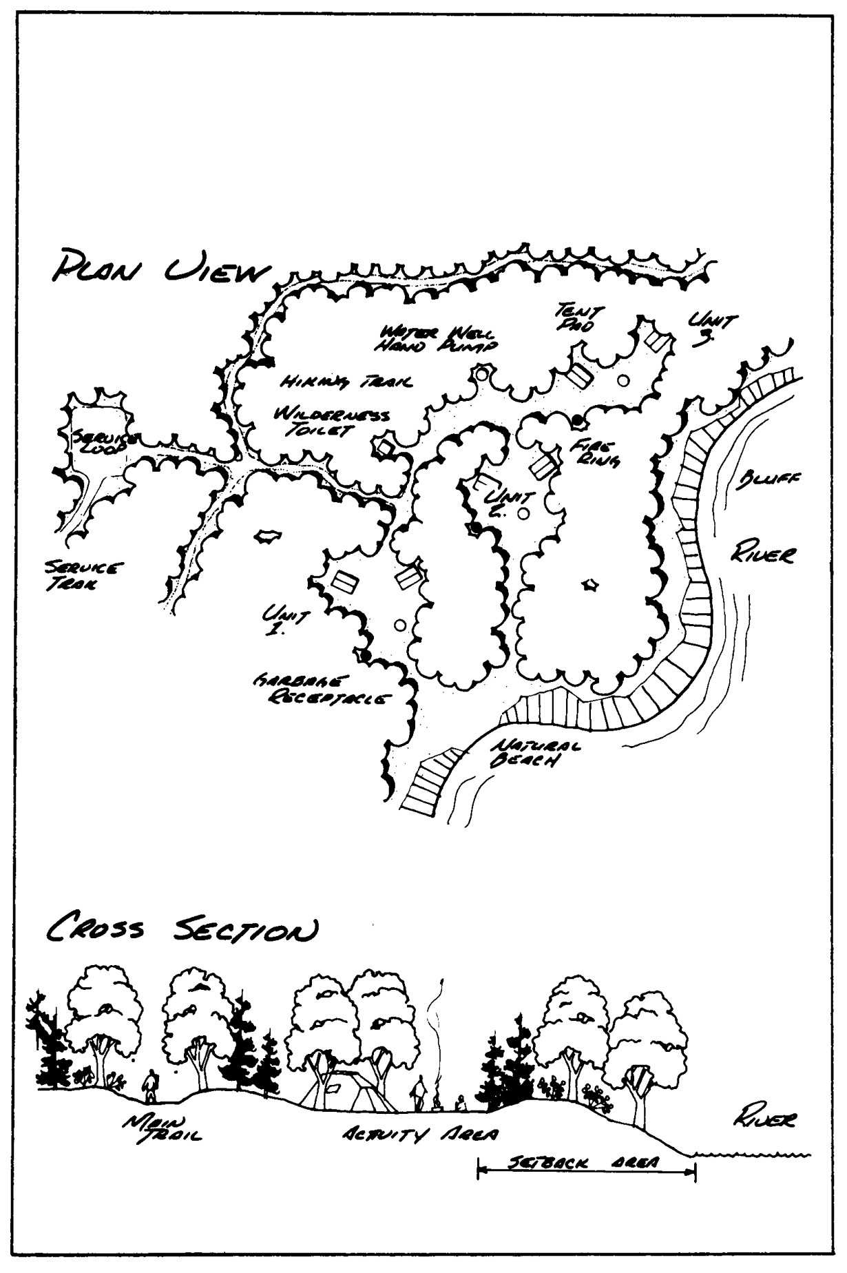
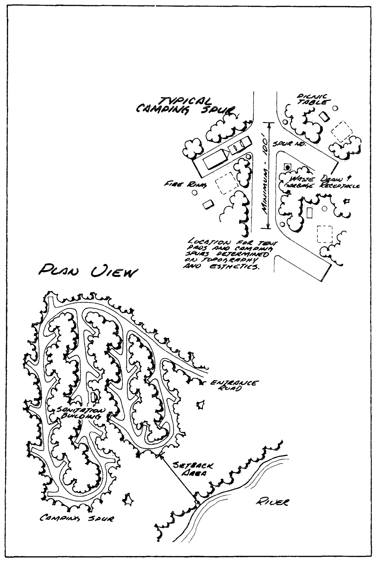
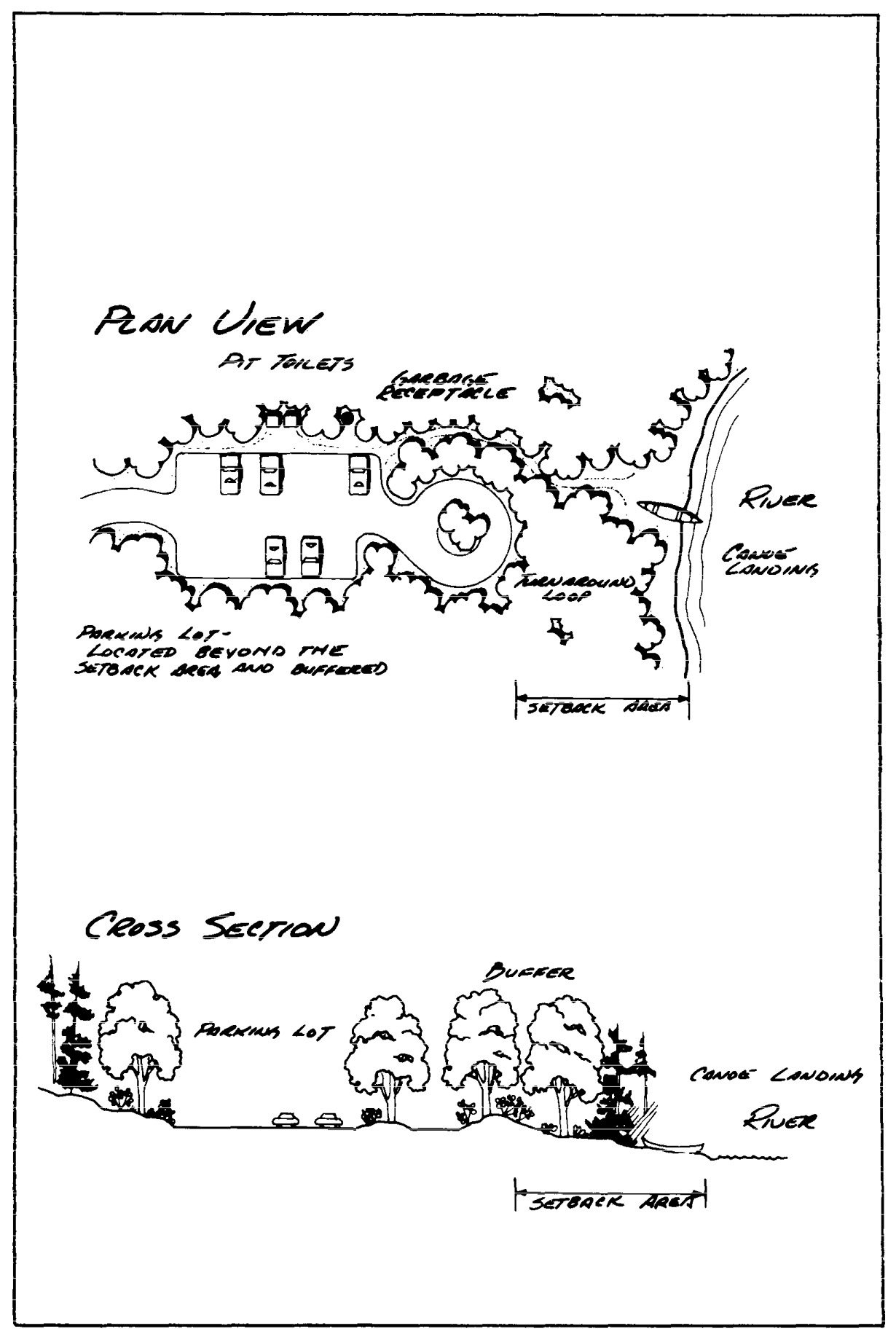
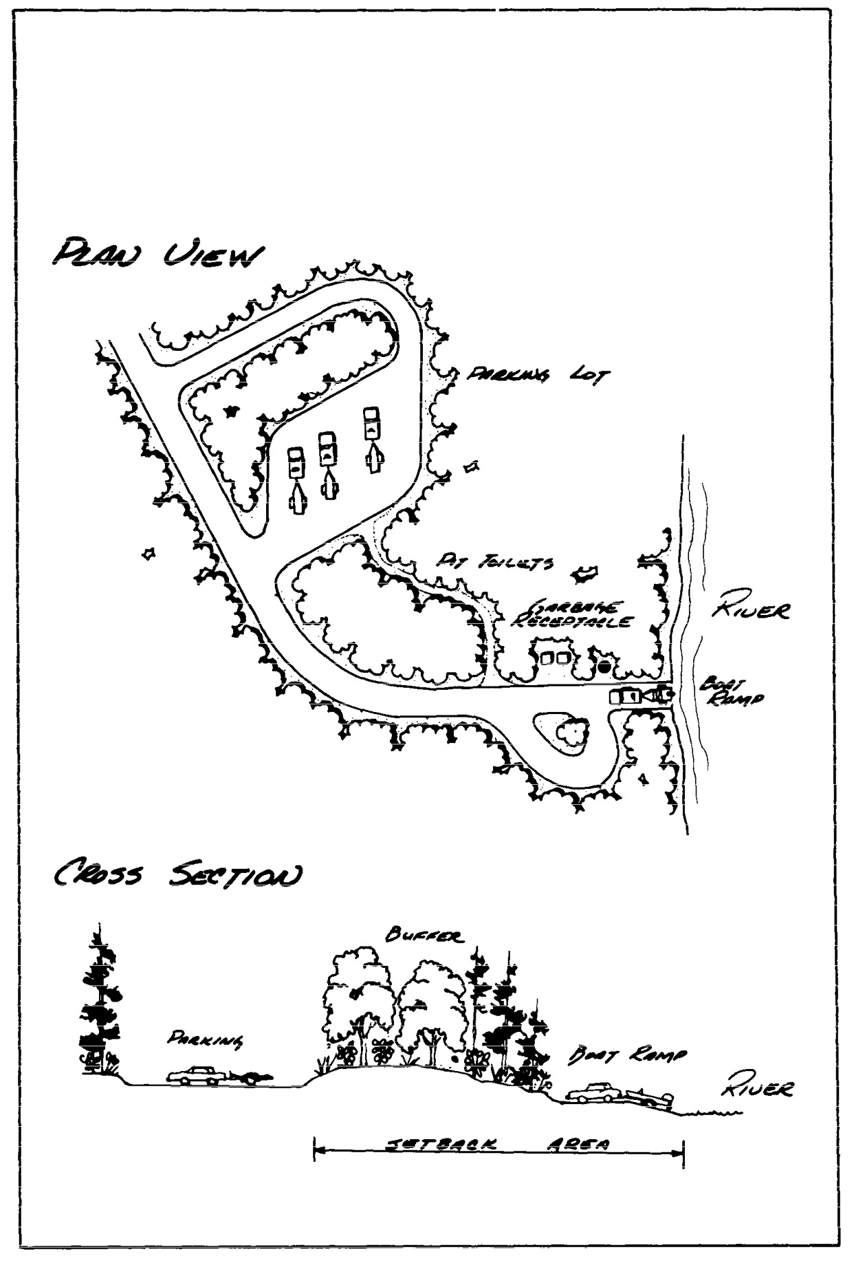
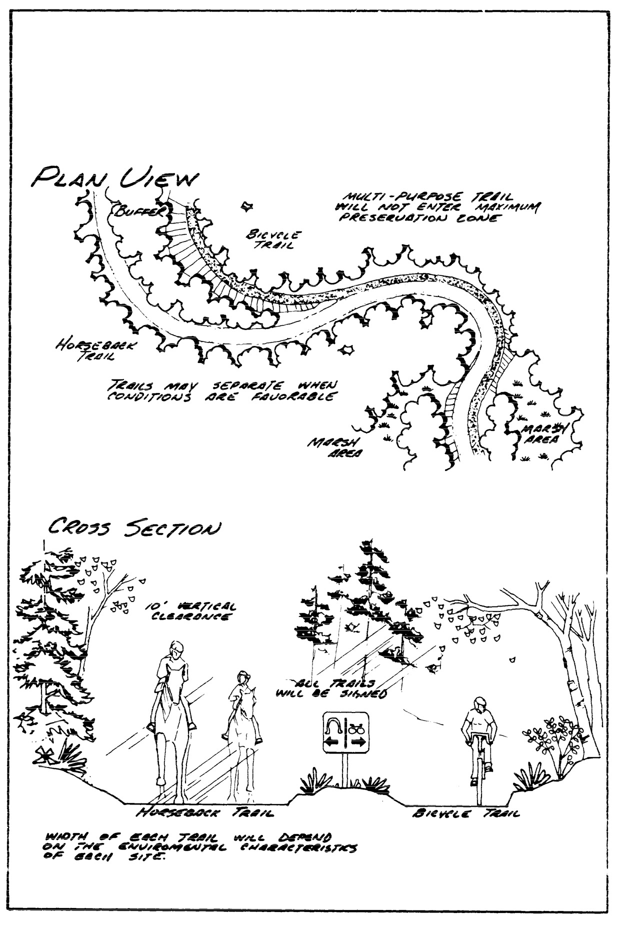
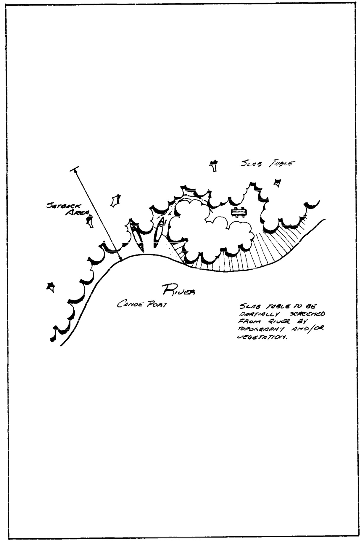
Statutory Authority:
MS s 104.35
Published Electronically:
June 11, 2008
Official Publication of the State of Minnesota
Revisor of Statutes